
Physical Divisions of Rajasthan is an important topic in the subject Geography of Rajasthan that explains the natural regional classification of the state based on landforms and terrain. Rajasthan is broadly divided into physical regions such as the Thar Desert, Aravalli Range, Eastern Plains, and Southeastern Plateau. These divisions help in understanding the state’s climate, soil, vegetation, and human settlement patterns.
Physical divisions of Rajasthan
- Based on the existing relief features, there are four physical divisions of Rajasthan:
- North Western Desert Region
- Aravalli Range And Hilly Region
- Eastern Plains
- South-eastern Plateau (Hadoti Plateau)
| North Western Desert | Aravali Mountain | Eastern plain | Hadoti plateau | |||
| Arid | Semi -Arid | |||||
| Area % | 61 | 9 | 23 | 7 | ||
| Population% | 40 | 10 | 39 | 11 | ||
| part | Tethys sea | Gondwana | Tethys sea | Gondwana | ||
| Time | Pleistocene | Pre -cambrian | Pleistosene | Cretacious | ||
| Soil | Sandy | Mountain | Alluvial | Black | ||
| Districts | 15 | 13 | 10 | 7 | ||
| Rainfall | 0-20 cm | 20-40cm | 40-60 cm | 60-80 cm | 80-120 cm | |
| Climate | Arid and semi -Arid | Sub humid | Humid | Maximum Humid | ||
| Vegetation (Koppen) | Xerophytes & thorny & steppe (Largest) | Dry Deciduous | Dry and wet | Savana(vagad hadoti+mt . Abu) | ||
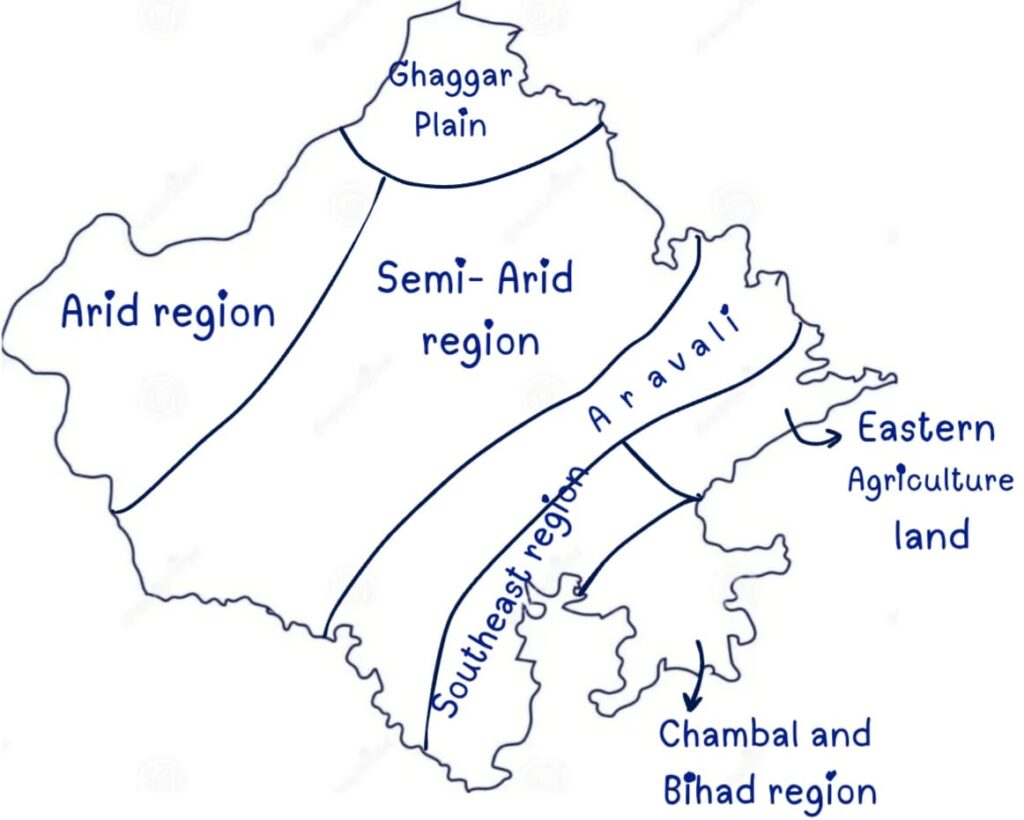
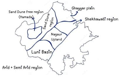
- Rajasthan is divided into 7 physiographic divisions according to the V.C. Mishra Book
- Ghaggar Plain
- Arid Region
- Semi -Arid Region
- Aravalli region
- Eastern agricultural land
- Chambal and Bihad region
- Southeast region
North -Western Rajasthan
Origin
- Formed in the Quaternary epoch or Pleistocene period. The slope of the desert is from North East to South West.
- The Tethys Sea covered western Rajasthan during the Permo-Carboniferous period.
- The saltwater lakes present here are considered to be remnants of oceans.
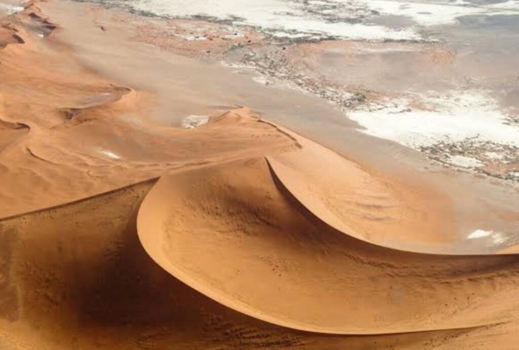
The Thar Desert
- About 85% of the Thar Desert is located in India, and the remaining 15% is in Pakistan.
- More than 60% of the desert lies in Rajasthan (62%), and the remaining extends into Gujarat, Punjab and Haryana.
Area
- It is the largest physical region, covers 61% of Rajasthan’s total area, including 15 districts (including new)
- Northern districts: Shri Ganganagar, Hanumangarh.
- Central districts: Churu, Jhunjhunu, Sikar, Nagaur, Deedwana-Kuchaman, Jodhpur, Phalodi, Pali.
- Western districts: Jalore, Barmer, Balotara, Jaisalmer, Bikaner.
Population Settlement
- North-Western Rajasthan contains 40% of Rajasthan’s population. However, it has the lowest population density in the state due to arid conditions.
- Characteristics
- This is the biggest region in size and can be divided into three parallel belts—Marusthali, Bangar and Rohi, which are spread from West to East.
- Sand mounds known as ‘Dhore’ in the local dialect are found here.
- Rainfall:- 25 cm to 50 cm annually (Rain shadow area of Aravalli)
- Climate: An arid and semi-arid type of climate is found.
- Soil:- Sandy soil.
- Major rocks:- Sedimentary rocks. There are vast expanses of sand & rock outcrops, mainly limestone, found in Jaisalmer, Barmer, Bikaner, Churu, Hanumangarh & Sriganganagar.
- Vegetation:- Xerophytes and thorny bushes, cactus, date palm.
- Agriculture:- Mainly Kharif crop is produced in large quantities; main crops are Bajra (pearl millet), Moth and Guar
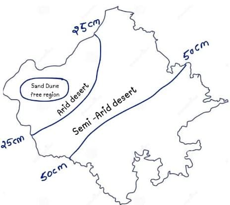
- 25 cm isohyet divides it into two parts (divided into two major regions and 6 sub-regions)
- The North-western desert, also known as the Thar desert Divided into 2 parts:
- Arid desert (Rathi region)
- Semi-arid desert
Arid desert (Rathi region)
- The arid desert is further divided into 2 parts
Without the Sand Dunes region
- It covers 41.5% part of the arid region.
- Dunes are not found in this region because the ‘Rocky Desert’ is found here.
- The Rocky Desert is called Hamada. Its extension is maximum in Jaisalmer (Pokaran, Lodrava, Ramgarh), Balotara and Phalodi.
- Reg:- This is a mixed desert found around Hammada; it is found in Jaisalmer, Balotara, and Phalodi.
- Erg:- It is called the complete desert and the great desert. It is spread in Jaisalmer, Barmer, Bikaner, Nagaur, Churu, Sikar, Jhunjhunu, etc.
- Lathi Series:-
- An underground water belt spread from Pokhran to Mohangarh in Jaisalmer over 60 km.
- This belt is considered to be the remains of the ancient Saraswati River.
- Nutritious grass like Seven (leelan), Dhaman, and Karad is also found in this region.
- Oasis:- (Nakhlistan)
- Formed near Playa lakes (temporary lakes ) in the desert.
- A place in the desert with greenery.

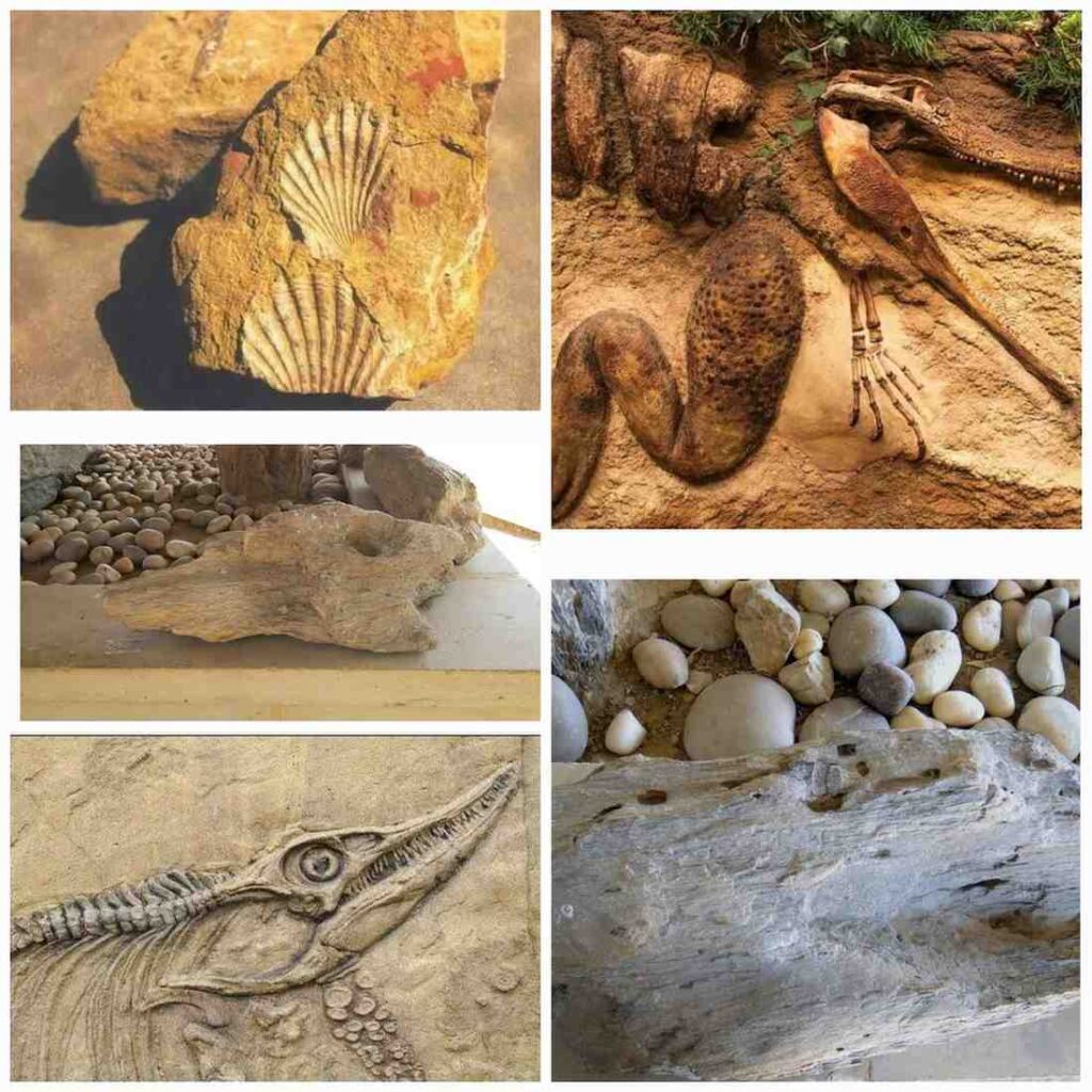
Akal Wood Fossil Park (Jaisalmer) :
- The formation period of these fossils is the Jurassic Period. (Before 180 Million years)
- Kuldhara – The first cactus garden is located here.
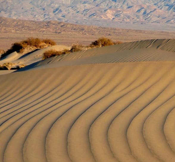
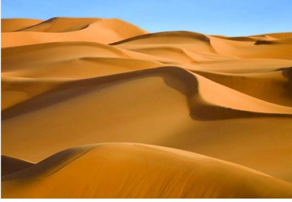
Sand Dune Region
- The Sand Dune region, which covers 58.5% of the Arid region.
- Sand dunes are Geographical structures formed by the deposition of fine soil by wind.
- According to Mr Mackie, 8 types of dunes are found in Rajasthan(1979).
- In the Rajasthan state, the maximum dunes are in Jaisalmer.
- All types of dunes are found in Jodhpur.
- Types of sand dunes–
Longitudinal/Linear Sand Dune
- These dunes are formed, parallel to the prevailing winds, also known as linear dunes.
- These dunes are mostly found in Jaisalmer, Bikaner, Suratgarh (Sri-Ganganagar).
Transverse sand dunes
- These sand dunes are formed at right angles (perpendicular) to the prevailing winds.
- These sand dunes are mostly found in Barmer, Jodhpur, part of Rawatsar (Hanumangarh), Suratgarh (Sri Ganganagar), Churu, and Jhunjhunu.

Barkhan
- These are the crescent-shaped dunes.
- The back side has a convex slope, and the front side has a concave slope.
- Mostly found in the Shekhawati Region, particularly in Churu.
- Crucial role in desertification because these dunes are highly dynamic.

Parabolic
- Mostly found on the opposite side of Barkhan and maximum in Rajasthan.
- Similar to a hairpin.
- Jaisalmer, Bikaner, Jodhpur
Star-shaped dunes
- Forms by changing the direction of the wind.
- Dunes have multiple ‘arms’, Resembling stars, formed when dunes converge from various directions.
- Mostly found in Mohangarh, Pokaran (Jaisalmer), Suratgarh (Ganganagar), and Bikaner.

Shrub Coppice and Nebkha
- Mostly formed around bushes.
- These small dunes do not cover much distance.
- The smallest type of dunes in the desert.
- Formed due to wind depositing sand around vegetation.

Seif dunes
- The extended arm of Barkhan is called seif.
- During the formation of Barkhans, when the wind direction changes, one arm of the Barchan extends forward, forming a structure known as a Seif Dune. Found in Shekhawati and Jaisalmer.
Obstacle Dunes
- These dunes are formed due to an obstruction (such as a hill or other barrier).
- Major locations – Pushkar, Budha Pushkar, Nagaur, Jobner and Sikar hills.
Network Dunes
- These dunes are found in the northeastern part of the desert. Major extension area: from Hanumangarh to Hisar (Haryana)
Semi-arid desert
- Semi – Arid Desert, also known as the Bangad Region, physical division which is located between the Arid Desert and the Aravalli region.
- A physical division which is located between the 25 cm Isohyet Line and the 50cm Isohyet Line is called the Semi-Arid Desert.
- Semi Arid Desert region is further divided into 4 parts –
Ghaggar Plain
- It is the northern part of the desert, which extends in the districts of Ganganagar and Hanumangarh. Also called the Nali or Paat area, formed by Alluvial soil brought about by the Ghaggar River.
- Nali –The plain area formed by the Ghaggar River in Hanumangarh is called Nali in the local language.
- Ghaggar Doab region – The fertile land between the Sutlej and Ghaggar rivers is known as the Ghaggar Doab region.
- Loamy fertile soil found in the Ghaggar river basin is called Kathi/Baggi.
- Thali- Elevated land in the desert is called Thali, mostly found in Bikaner and Churu.
- Over-irrigated area, which causes problems of Alkalinity.
Shekhawati Inland Drainage Region
- The semi-arid plain extends in the districts of Jhunjhunu, Sikar, Churu and northern Nagaur. It is a sandy plain covered with sand dunes of medium and low height.
- This region is also called the Bangar region.
- Barkhans are dominant in the region.
- It is an area of inland drainage. There are rivers and nallas which disappear after flowing for a short distance in the region. Mentha, Kantli, Khari, and Rupangarh are the major rivers of this area.
- Torawati:– The drainage/catchment area of Kantali is called Torawati.
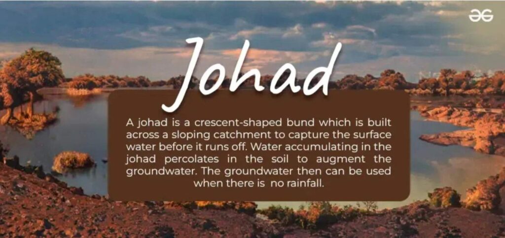
- Johad:- Raw wells of water are called Johad.
- Sar/Sarovar – water bodies formed by water accumulation between dunes, examples Jassusar, Mansar, Salasar.
- There are several saltwater lakes (Sambhar, Deedwana, Kuchaman), and Ranns {sujangarh, Tal – Chhapar and Parihara (Churu)} in this area.
- Beed:- The Pasture Land is called beed. It’s listed in the conservation reserves of Rajasthan State.
Luni Basin (Godwad region)
- Extends from Jodhpur, Jalore, Pali, Balotra, and Barmer.
- Alluvial plain formed by the Luni River and its tributaries, which is called ‘Luni Basin’ or ‘Luni Jawai Basin’. Salinity is also visible on land in some areas adjacent to the Rann of Kutch.
- Soil – New alluvial soil which covers 47.51 per cent of the entire Luni basin.
- It is spread over 35,000 sq km. The most humid region of Western Rajasthan.
- Main canal of Luni basin – Narmada Canal
- The entire area of this region is plain, but some solitary hills are also located in this region, the main ones of which are as follows –
- Chappan Hills – Circular hills about 11 km long and 1.5 km wide are spread from Mokalsar village to Siwana in Balotra. Being a group of 56 hills, they are called ‘Chhappan ki Paharis’. Granite is found in abundance in it, hence also known as ‘Granite Mountain’.
- Peeplood (Balotra) – It is called the Mount Abu of the desert or the Little Mount Abu of Rajasthan. It is the place with the highest rainfall in western Rajasthan. The temple of Haldeshwar Mahadev is situated in Peeplood
- Jalore – Siwana Hills are famous for Granite reserves (Jalore is called Granite City). Hills made of granite and hills of Malani rhyolite are found in the form of domes and inselbergs. These are spread up to Mandalia, Hemawas, Ravaniya, Chotila, Khejarla, Kakni, and Mogra Khur.
- Malani Hills – famous for limestone reserves.
- Nakoda Hills (Balotra) – This is a religious place of Jainism. The Parshvanath temple is built here, which is known as Nakoda Bhairava.
- Sendra Hills (Beawar) – Rocks of various shapes, including serpentine, are found in Sendra (Beawar).
- Rann of Nehra (Neerhad) – is located in this basin, mostly in Jalore.
- Luni Basin, also known as Godwad Basin, extends across parts of Jalore, Pali, Barmer, Sirohi and Jodhpur.
- In this Basin saline plants (Halophytes) are found mostly in Barmer.
- “Rann of Nehar” is located in this basin, mostly in Jalore.
- “Kala Bhura Dungar” is located in Pali to the east of this basin.
- There are alluvial plains in the drainage areas of Luni and its tributaries like Lilri, Sukari, Jawai, Jojari and Bandi.
- Pachpadra is the major brackish water area in the region where salt is made.
Nagori Upland
- Sandy barren areas free from dunes extend in Nagaur and Ajmer.
- This region is a 300 to 500-meter-high land region.
Classification of the Nagauri highland region
| Classification of the Nagauri highland region | |
| Makrana Range | White marble deposit area |
| Goth Mangold range | Gypsum deposition area |
| Jayal range | Fluoride-rich water |
- Inland water drainage is mainly found. Some salty lakes in the eastern parts of this region are Sambhar, Didwana, Nawa, and Kuchaman.
- Source of salt in lakes
- The micaceous salty rocks found beneath the soil from which the salt comes to the surface by capillary action, which then turns into sodium chloride after evaporation.
- During the rainy season, small rivers collect salt particles along with water and bring them here (inland drainage). Soil contains excess sodium chloride, so it’s unfit for agriculture.
- Hump belt/kubad patti – Due to evaporation of salty water, salt gets accumulated in pits which have a high content of fluoride. The hump belt is found between the borders of Nagaur and Ajmer, but the area from Jayal to Pushkar is most affected.
- Fluorosis disease is very commonly seen in residents, in which teeth become yellow, bones become crooked, back bends due to which people develop humps, hence it is called Hump Belt/Banka Patti.
Important keywords related to the desert of Rajasthan:-
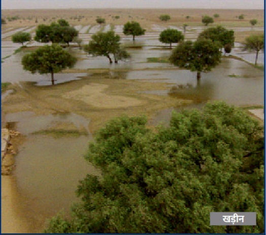
Playa and Khadeen Lakes
- Temporary lakes are called Palaya lakes in western Jaisalmer.
Khadeen Lakes
- In western Jaisalmer khadeen lakes were founded by Paliwal Brahmins. These lakes were used for agriculture by them.
- Rabi Crops are mainly sown in these lakes. Playa and Khadeen are mostly found in western Jaisalmer.

Rann
- In desert marshy, saline and infertile land is called Rann/Taat/Dhaad. These are maximum found in Jaisalmer and Barmer. Some examples are Tal Chhapar, Padihara (Churu), Thob (Balotara), Pokaran, Bhakari (Jaisalmer), Baap (Phalodi).
Peevna
- It is a species of snake with yellow colour, mainly found in Jaisalmer.
Bap Boulder Clay
- Boulder Clay is mostly found in Jodhpur.
- Note:-Presently in Phalodi (according to the Gazetted notification -2024)
- Sediments and large stones formed by deposition from glaciers or ice sheets are called Boulder clay.
- The formation period of Boulder clay is the Permo-Carboniferous(250-280 million years ago).

Dhore and Dharyan
- Shifting dunes are known as Dhariyan, and wavy types of dunes are known as Dhore.
- Dhore and Dharyan are mainly found in Jaisalmer.
March of the Desert
- Shifting of the desert is known as the ‘March of Desert’.
- Barkhan dunes contribute the maximum to desertification.
- In Rajasthan, the direction of the desert March is from Southwest to Northeast.
Balson
- The water basins or lakes found in the middle of the mountains in the desert are called Balson. Example: Sambhar Lake.
Aravali Range of Rajasthan
Development of Aravali
- The Aravalli range developed as igneous rocks due to magma solidification in the Pre – Cambrian era (around 2500 million years ago).
- Due to the process of contraction, it evolved into an ancient folded mountain, considered an example of Peneplanation (Peneplain).
Aravalli Base in Rajasthan
- The base of the Aravalli range is visible in the Tonk district, where its rock formations are found beneath the surface.
- The earliest rocks of the Aravalli range in Rajasthan belong to the Archean series, which are solid, granular, and fossil-free.
- This series contains granite, gneiss, and schist minerals.
- Impact of the Vindhyan Series: Currently, most of the Aravalli range consists of Vindhyan series rocks, classifying it as a residual mountain.
- According to Prof. Parikh, Vindhyan rocks in Rajasthan extend from Dholpur to Chittorgarh in the east and from Nagaur to Birmania in the west.
- Part of the Peninsular Plateau: Geomorphologically, the Aravalli Range is a part of the Indian Peninsular Plateau.
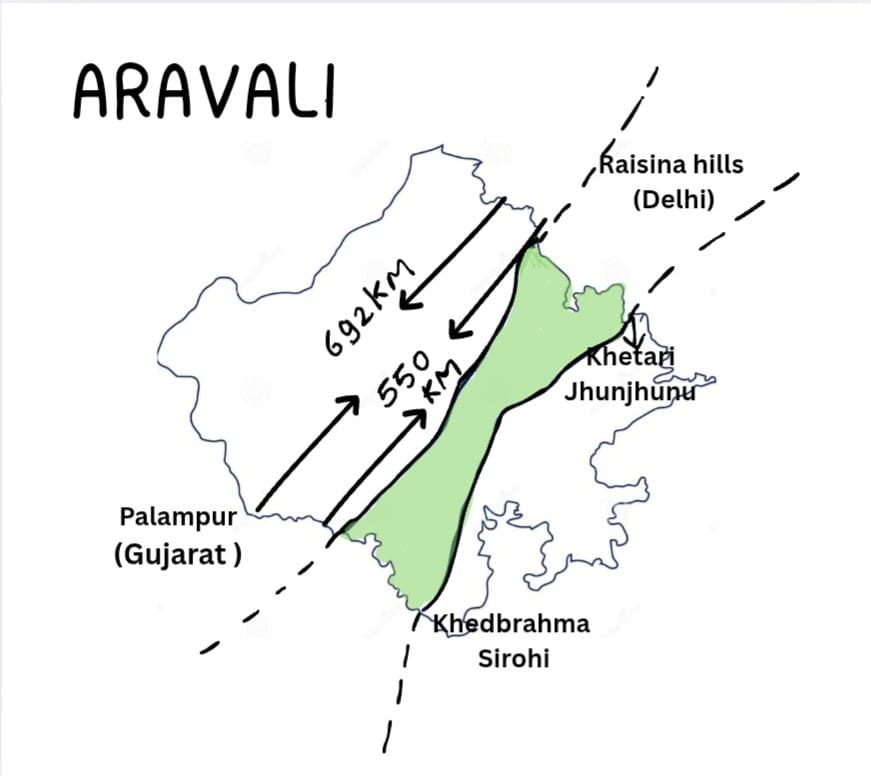
Extension and Geographical Location
- Extension: In India extended from Palanpur (Gujarat ) to Raisina Hill (Delhi) over 692 kilometres. In Rajasthan, it is extended from Khedbrahma (Gujarat border) to Khetri (Jhunjhunu) over 550 kilometres.
- Height: 600-900 m; Average – 930 Metres.
- Extension direction: South – West to North – East.
- Covered districts-9: Sirohi, Udaipur, Rajsamand, Ajmer, Jaipur, Sikar, Jhunjhunu, Dausa, Alwar (according to V.C Mishra)
- 7 districts (according to Harimohan Saxena’s book).
- Its height declines from south to northeast. Gurushikhar of Mount Abu in Sirohi district is the highest peak of the Aravali having 1722 meters.
- Colonel James Todd has called it – “The peak of Saints”. It is the highest peak between the Himalaya and the Nilgiri.
Climate and Ecology
- Rainfall: Annual average rainfall of 50 – 90 cm.
- Climate: Semi-arid climate.
- Soil Types: Black, Brown, Red (Mountain Soil).
- Vegetation and Biodiversity: Dry deciduous forests are found here.
- Major trees: Dhok, Babool, Neem.
- Floral species: Rose, Bougainvillaea, Hibiscus.
- Agriculture and Economic ActivitiesMajor Crops :
- Kharif (Monsoon) Crops: Maize.
- Rabi (Winter) Crops: Wheat, Gram, Mustard.
Division of Aravali:- Aravalli is divided into three parts
Northern Aravalli
- 450 meters average height
- Extension:- It’s located between Khetri (Neem ka thana ) and Sambhar (Jaipur).
- Districts:- Jhunjhnu, Jaipur, Kherthal-tijara, Kotputali-Behror, Sikar, Alwar.Mountain peaks of Northern Aravallis
Mountain peaks of Northern Aravallis
| Mountain peaks of Northern Aravallis | |
| Mountain peaks | Height (in meters) |
| Raghunathgarh (Sikar) | 1055 m |
| Malkhet (Sikar) | 1052m |
| Lohargal (Jhunjhunu) | 1051m |
| Bhojgarh (Jhunjhunu) | 997m |
| Kho (Jaipur) | 920 m |
| Harshnath (Sikar) | 820m |
| Bhairanch (Alwar) | 792m |
| Barbara (Jaipur) | 786m |
| Babai (Jhunjhunu) | 780m |
| Bilali (Alwar) | 775 m |
| Manhorpura (Jaipur) | 747m |
| Sirawas (Alwar) | 651m |
| Bhangarh (Alwar) | 649m |
| Jaigarh (Jaipur) | 648m |
| Nahargarh (Jaipur) | 599m |
| NOTE:- Mentha river originates from Manhoarpura, Banganga river originates from Bairath, and Ruparel river originates from Sawer hills. | |
Middle Aravali
- Average height is 500 – 700 m.
- Extension:- From Sambhar (Jaipur) to Devgarh (Rajsamand)
- Districts: Ajmer, Beawar, Rajsamand, Jaipur, some parts of Pali, Bhilwara, and Tonk.
- Granite, marble and quartz rocks are found.
Mountain peaks of the Central Aravallis
| Mountain peaks of the Central Aravallis | |
| Mountain peaks | Height |
| Morarji/Todgarh (Beawar) | 934 m |
| Taragarh (Ajmer) | 873 m |
| Nag Pahar (Ajmer) | 795m |
Southern Aravali
- Deogarh (Rajsamand) to Khedbhrahma (Sirohi – Gujarat) border.
- Districts:- Rajsamand, Sirohi, Jalore, Udaipur, Chittorgarh, Slumber, and some parts of Pali.
- Southern Aravali is further divided into 2 parts:–
- Abu Aravali:- It’s mainly located in Sirohi, Jalore and Pali.
- Mewar Aravali:- It’s mainly located in Udaipur, Slumber, Chittorgarh and Rajsamand. Jarga (1431 Meters – Udaipur) is the highest peak of Mewar Aravali.
- Note:- According to A. M. Heron Aravali was formed
| Delhi Super Group | ||
| Alwar group | Ajabgarh group | Railo group |
Plateau of Aravalli
Udiya Plateau
- It is located in the southern Aravali in Sirohi.
- The height of the Udiya Plateau is 1360 Metres.
- It is the highest plateau of Rajasthan.
Bhorat
- It is located in the southern Aravali from Udaipur (Gogunda Hills) to Rajsamand (Kumbhalgarh Hills).
- The height of Bhorat is 1224 Metres.
Abu block
- It is a plateau.
- Abu block is located in the southern Aravali in Sirohi.
- The height of Abu Plateau is 1200 Meters.
- Abu block is an example of Batholith Structure.
The Mesa plateau
- It is located in Chittorgarh (620 meters).
- Longest plateau by area in Rajasthan.
Lasadiya
- Located between the Slumber to Pratapgarh in the east of Jaisamand Lake in the South Aravali.
- It is a badland plateau.
Uparmal Plateau
- It is located between Bhainsroadgarh (Chittorgarh) and Bijolia (Bhilwara).
Kranshka and Kankanwari
- Located in Alwar and part of the North Aravali.
- These plateaus are located in Alwar (Sariska Sanctuary).
Bhomat plateau
- Located in southern Udaipur, northern Dungarpur and eastern Sirohi.
Mandeshra plateau
- Located in Bhainsroadgarh (Chittorgarh) district.
Passes of the Aravali Mountain Range
| Passes of the Aravali Mountain range | Location |
| Someshwar, Hathi Guda, Kamli, Goram, Pagalya, Jeelwa Naal | Rajsamand |
| Maximum passes are located in Rajasamand | |
| Pagalya pass | Connects Mewar (Rajsamand) to Marwar (Pali) |
| Hathi ghuda (Rajsamand) | Connects Rajsamand and Udaipur to Sirohi |
| Dhebar (Slumber) | Earlier was in Udaipur. Jaisamand Lake is situated in this pass, hence called Dhebar lake also. |
| Kewda, Phulwari, Hathi | Udaipur |
| Bar pass | Connects Bar Pali Marwar to Ajmer (Beawar), Merwar NH-162 & NH -25 pass through here. |
| Desuri pass (Pali) | Connects Pali to Rajsamand |
| Parwarya pass, Sura pass and Bar Naal | Located in Beawar |
| Sura Ghat | Connects Beawar to Bhilwara |
| Parveria Pass | Connects Beawar to Masuda |
| Shivpuri pass | Connects Beawar to Vijaynagar |
| Swaroop Ghat pass, Jhilwara pass Udabari pass | Ajmer |
| Kachhawali pass | Todgarh, Beawar |
| Arnia pass | Ajmer |
| Peepal pass | Highest altitude pass in Todgarh (Ajmer) |
| Debari Nal | Connects Chittorgarh to Udaipur |
| Borang Pass | Connects Sirohi to Udaipur |
Important Facts
- Desharo – located between Jarga and Raga Hills in Udaipur. The region is Rich in vegetation.
- Merwara hills:- The nearby hills of Ajmer are called Merwara hills.
- Girwa: A series of mountains or disc-shaped hills is called Girwa. Udaipur City is located in the Girwa Hills.
- Circular-shaped hills are found in Barmer and Balotra. Maximum in Balotra.
- Horseshoe-shaped hills – Baran
- Cresent shaped hills – Bundi
- Bhakar – The steep and rugged area to the west of Sirohi and Jalore is called ‘Bhakar’ in the local language, i.e. Roja and Israna Bhakar.
- Magra – North-west part of Udaipur.
- Piedmont Hills– Piedmont is an area at the base of a mountain or mountain range, which is formed by erosion. Mostly formed in Deogarh (Rajsamand).
- Inselburg – An isolated, steep-sided rock hill or irregular plateau is called inselburg mainly found in Mount Abu in Sirohi, formed by wind erosion.
- Batholith – Abu block have batholith type of structure.
Important hills of Rajasthan
|
Important hills |
Districts |
|
|
|
Rajsamand |
|
Jaipur |
|
Kotputli – Behror |
|
|
|
Note: 1st ropeway at Sundha Mata Temple (Jalore) and 2nd ropeway at Machla Magra in Udaipur. |
|
|
|
|
|
|
|
|
|
|
Barmer (Siwana) |
|
Sirohi |
|
Ajmer |
|
Sawai – Madhopur |
|
Alwar |
|
Bundi |
|
Bhilwara |
|
Beawar |
|
Pali |
|
Kota, Jhalawar |
Importance of Aravali
- The water divide: It separates the drainage system of Rajasthan into two parts. The Arabian Sea and Bay of Bengal. Most rivers of Rajasthan originate from the Aravali. Source of many freshwater lakes. (Ex .- Nakki, Pichola, Anasagar, etc.)
- Motherland of Ancient Civilisation (Aahad, Bairath, Ganeshwar and Gilund) and Modern (Jaipur, Ajmer and Udaipur).
- Source of minerals:- The region is dominated by granite and gneiss quartzite rocks of the Dharwad series
- Metallic Minerals:- Iron ore, copper, lead, Zinc tungsten, silver, etc.
- The barrier against desertification:- The Aravalli Range acts as a natural barrier between the Thar Desert and the fertile plains, preventing desertification from spreading eastward.
- Biodiversity (flora and fauna) – Supports many species of plants and animals.
- The area is home to various notable wildlife species, including the endangered Great Indian Bustard, the blackbuck, leopard, tigers and hyenas.
- Tourism: The natural beauty, historical forts, wildlife sanctuaries and spiritual sites attract millions of tourists annually, contributing to the local and national economy.
- Impact on Rajasthan’s Climate: The Aravalli Range runs parallel to the southwest monsoon, which prevents it from obstructing monsoon winds, making most of Rajasthan arid.
Aravali Green Wall Project
- Objective: The Aravalli Green Wall Project aims to combat land degradation by creating a 1400 km long and 5 km wide green corridor around the Aravalli mountain range.
- Inspiration: The project is inspired by Africa’s Great Green Wall initiative, which stretches from Senegal to Djibouti.
- Geographical area: The project covers 29 districts of Haryana, Rajasthan, Gujarat and Delhi, spanning an area of about 60 lakh hectares.

- Start: Launched on 25 March 2023 by Union Minister for Environment, Forest and Climate Change from Tikali village of Haryana.
- Land restoration: Target to restore 11.5 lakh hectares of degraded land by 2027, particularly in Rajasthan (81%), Gujarat (15.8%), Haryana (1.7%) and Delhi (1.6%).
- Biodiversity conservation: Promoting biodiversity by planting native trees (such as Arjun, Dhak, Khejri, Banyan) in the Aravalli region, which includes endangered species such as the Indian wolf, leopard and sloth bear.
- Water conservation: Regeneration of 75 water bodies in the initial phase, promoting groundwater recharge and soil moisture conservation.
- Air pollution reduction: Improved air quality by reducing dust storms from Rajasthan to Delhi, which contribute to 40% of Delhi’s PM2.5 levels in summer.
- Employment Generation: Tree plantation target. Plan to plant 5 crore native trees.
Recent news related to Aravali
What is the issue?
- New Height – Based definition:– The Centre has defined Aravalli Hills as landforms rising ≥100 metres above local relief, narrowing their legal recognition.
- Shift from scientific mapping:- This replaces the forest survey of India’s 3 – degree slope method.
- Large – scale exclusion risk – Many low-elevation Aravali tracts, especially in Delhi NCR and Rajasthan, may lose protection.
- Beyond mining concerns – Even if mining is restricted, derecognition can allow construction, urbanisation and real estate expansion.
- Long-term ecological impact – Experts have warned of increasing water scarcity, heat waves, dust storms and biodiversity loss due to fragmented protection.
Supreme Court judgement on Aravalli Hills
- In its judgment delivered on November 20, 2025, the Supreme Court accepted the definition proposed by the Centre-led committee.
- It states that: Only hills that rise 100 meters or more above the local terrain are called Aravalli Hills.
- #Save Aravali mass movement started after this judgement. Finally central government cleared their stance on the recommendations.
- In a major step towards conservation and protection of the entire Aravalli Range stretching from Delhi to Gujarat from illegal mining, the Union Ministry of Environment, Forest and Climate Change (MoEF&CC) has issued directions to the States for a complete Ban on the Grant of any New Mining Leases in the Aravallis.
- This prohibition applies uniformly across the entire Aravalli landscape and is intended to preserve the integrity of the range. The directions are aimed at safeguarding the Aravallis as a continuous geological ridge extending from Gujarat to the National Capital Region, and at stopping all unregulated mining activities.
Eastern Plain Region
- The Eastern plain was formed in the Pleistocene Period.
- The plain is made up of fertile alluvial soil and is irrigated by several rivers situated between the Aravallis and the Hadauti plateau.
- The region covers 23 % area and 39% population density of Rajasthan.
- The eastern plain region of Rajasthan has been formed by the Chambal, Banas, Banganga, and their tributaries, which are an extended part of the Gangetic plain.
- There are 10 districts in Rajasthan, located in the eastern plains.
- Districts – Sawai Madhopur, Karauli, Dholpur, Bhilwara, Tonk, Bharatpur, Jaipur, Dungarpur, Pratapgarh, Banswara.
- Slope – The slope of the eastern plain region is from southwest to the northeast, but specifically speaking of its parts, the southern part has a slope towards the west (the Mahi River flows towards the Bay of Cambay).
- Chambal basin – south to north, Banas basin – west to east.
- Rainfall – 50 – 80 cms annually
- Soil – Alluvial soil
- Climate – Humid climate
- Maximum irrigation by wells, the most fertile region of Rajasthan, with the highest population density
- Agriculture -This is the area with maximum agricultural development, called the ‘Food bowl of Rajasthan’.
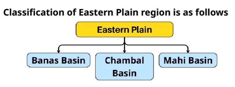
Banas – Banganga Basin
- Banas river plain:-
- The plain of Banas and its tributaries is known as the plain of Mewar in the south and the plain of Malpura Karauli in the north. Berach, Khari, Mansi, Morel and Banganga, etc., are the main tributaries of the Banas River.
- The plain slopes east and north – eastwards. There are flat-topped isolated hills in the region. The plain averages in height between 280 and 500 meters.
- Banas Plain is further divided into 2 parts.
- Mewar Plain-
- The southern plain of Banas is known as the Mewar Plain.
- Its extension is in Rajsamand, Bhilwara and Chittorgarh. Mostly brown soil is found here.
- Malpura – Karauli Plain –
- The northern plain of Banas is known as the Malpura-Karauli plain. Its extension is in Ajmer, Sawai Madhopur and Tonk. Brown soil is found in the plains.
- Malpura-Karauli Plain – It is called “the hird peneplain” by A. M. Heron.
- Mewar Plain-

Ban Ganga Plain
- The Ban Ganga plain is located in Jaipur, Dausa, Kotputli-Behror, and Bharatpur. Alluvial soil is found here.
- Rohi Plains – The plain region situated between the Ban Ganga and Yamuna rivers, between Jaipur and Bharatpur, is known as the Rohi Doab region.
- Kherad plain – It is a rough, irregular plain spread in Shahpura (Bhilwara) and Tonk districts
- Mal Kherad – Malpurase area of Tonk district.
Chambal Plain
- Badland plain formed by Gully Erosion of the Chambal River, known as Ravines or Dang plain.
- The Chambal plain is extended in Kota, Bundi, Karauli, Dholpur and Sawai Madhopur.
- Slope and Elevation
- The slope of the Chambal Basin is towards the east. Elevation ranges between 150 and 300 meters above sea level.
- Districts in Rajasthan :Kota, Bundi, Baran, Jhalawar, Sawai Madhopur, Karauli, Dholpur.
- New alluvial (New Alluvial deposits) are found in this basin. The most prominent landform of the Chambal Basin is the Beehads (badlands).
- Slope and Elevation
- Cause of Behad’s formation: Gully erosion caused by the Chambal River.
- Distribution of Beehads: is mainly spread across Sawai Madhopur, Karauli and Dholpur districts.
- Highest density of Behads: Dholpur district.
- Largest expansion of Beehads: Sawai Madhopur district.
- “Karauli” is known as the “Queen of Beehads”.
Mahi Basin
- The southern plain of Rajasthan is called the Vagad Plain. Extends over Banswara, Pratapgarh & Dungarpur, called the Chappan Basin, Bhati plain.
- Chappan plains – There is a group of 56 small rivers and streams between Banswara and Pratapgarh. The plain formed by these is called the Chappan plain.
- Kanthal – The catchment area of the Mahi River in Pratapgarh is called Kanthal. The ancient name of Pratapgarh was Kanthal, so Mahi is also known as “Kanthal ki Ganga”.
- Red loamy soil is found – suitable for rice, maize and sugarcane production. Slope – towards the west, with an average height of 200 – 400m
Importance of the Eastern Plains of Rajasthan
- Agricultural Productivity
- The region has loamy and alluvial soils, which are highly fertile. Major crops include wheat, barley, mustard, sugarcane, chickpea and paddy.
- Adequate irrigation facilities such as wells, tubewells and dams are available.
- Population Density
- Due to fertile land, water availability and employment opportunities, the population density is high. The rate of urbanisation is also significant.
- Basic Infrastructure
- Facilities related to Roads, Railways, Power supply, Education and Healthcare are well developed. Cities like Jaipur serve as important administrative and commercial centres.
- Industrial Development
- Jaipur, Alwar, Bhilwara and Ajmer are major industrial centres. The region has developed industries such as textiles, metal, cement, automobiles, and handicrafts.
- Avifauna and Biodiversity
- The Keoladeo National Park of Bharatpur is a famous bird sanctuary. Numerous migratory birds visit the area during winter.
- Cultural and Historical Importance
- Cities such as Jaipur, Alwar and Karauli are significant from historical and cultural perspectives. Numerous forts, Temples and heritage sites represent the identity of this region.
South-Eastern Plateau
- The plateau was formed by basalt lava from volcanic eruptions in the Cretaceous period.
- The south-eastern plateau of Rajasthan is popularly known as Hadauti. It covers 9 % area and 13 % of the population of Rajasthan.
- The South – Eastern Plateau is divided into two major divisions and three subdivisions.
Deccan Lava Plateau
- Located in the southern part of Hadoti and is an extension of the Malwa plateau in Madhya Pradesh.
- Its extension in Malwa and Uparmal Region
- Malwa Region:- Pratapgarh and Jhalawar are included in this region, where the Malwa Plateau region extends.
- Uparmal Region:- It is a plateau region which is extended from Bhilwara (Bijoliya) to Chittorgarh (Bhainsrorgarh).
- It is composed of sandstone and limestone rocks.

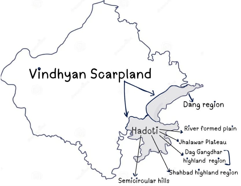
Vindhyan Scarpland
- It extends in the Southeast of Hadoti. The scarp faces south – east and eastwards continuously between the Banas and Chambal rivers.
- Many rocks and Minerals like Red stone, Limestone, Kota Stone, Sandstone are found in the Vindhyan Scarpland. Red stone and Sandstone are found in maximum.
- Vindhyan Scarpland is further divided into 2 parts :
Dang
- Area Covered:- Karauli, Dholpur and Sawai Madhopur.
Hadoti
- Area Covered:- Baran, Jhalawar, Kota, Bundi.
- Hadoti has 5 Sub-divisions:-
- Semicircular hills – There is a semi-circular spread of mountain ranges on the plateau of Hadoti, which are known as Bundi and Mukundara ranges, respectively.
- Bundi Hills- 96 km long semi-circular hills located in Bundi district, whose highest peak is Sattur (353 meters).
- Mukundra Hills (Kota -Jhalawar)- The Hadoti Plateau consists of a semicircular range of hills, approximately 120 km long. Its average elevation is 335 to 503 meters above sea level. Its highest peak is Chandwari (517 meters). The Kali Sindh River winds its way through these ranges and is joined by the Ahu River at Gagron.
- River Formed Plains – Surrounded by Bundi and Mukundra mountain ranges is the plain region of about 7,885 sq km formed by Chambal and its tributary rivers.
- Shahabad Highland Region– it is a relatively high region of the Hadoti plateau. A unique mountain range near Ramgarh village. It is formed remotely on a flat area.
- Note – Ramgarh Hills– The hills are situated between Bundi and Baran are called horseshoe-shaped hills in the Bundi district.
- Jhalawar Plateau– Towards the south of the Mukundra ranges is a plateau region of about 6183 sq km with a height of 300 to 450 metres. This is an integral part of the Malwa plateau. Black soil is found here.
- Dag Gangdhar highland region– This is a highland area formed of lava extending over Jhalawar. Note- Kundla Hills- The coil-shaped hills around Kota are called Kundla Hills.
- Semicircular hills – There is a semi-circular spread of mountain ranges on the plateau of Hadoti, which are known as Bundi and Mukundara ranges, respectively.
Major passes located in Bundi
- Ramgarh Pass
- Lakheri pass
- Khatkar pass
- Jetawas pass
- Bundi pass
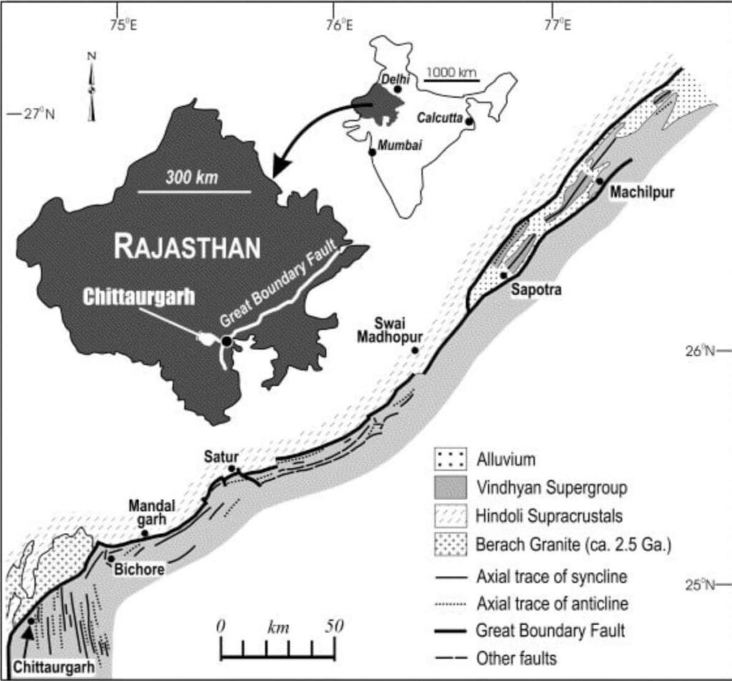
Great Boundary Fault
- Extended in Chittorgarh, Bhilwara, Bundi, Karauli, Dholpur and Sawai Madhopur.
- The Great Boundary fault is situated East of the Aravali and on the northeast side of the Hadoti region.
- The GBF is a branching reverse fault that extends from peninsular India to the Sub – Himalayas. It formed due to tectonic pressures.
- Geological Impact: The GBF influences the region’s topography, mineral resources, water flow, and soil composition.
- Mukundra Hills are an extension of vindhyan hills of Rajasthan.
Characteristics of the Hadoti Plateau
- The Southern – East part of Rajasthan is covered by the Hadoti Region.
- Geological Structure
- Formed from Cretaceous period basaltic rocks.
- Major mineral resources: Sandstone, Red stone, Kota stone, Limestone
- Soil and Agriculture
- Black soil (Vertisol) dominates due to volcanic activity and lava fragmentation.
- Major crops: Soybean, Coriander (Highest production in Rajasthan), Cotton, Sugarcane
- River System
- The Chambal River (the largest tributary in Rajasthan) flows through this region.
- Other major rivers: Kalisindh, Ahu, Parvan Ghodapachhad, Kunnu, Parvati. Most rivers in Rajasthan flow through Hadoti, causing severe soil erosion.
- Rainfall and Climate
- The Bay of Bengal monsoon enters Rajasthan through Hadoti.
- This branch contributes to nearly 90% of Rajasthan’s total rainfall.
- Highest rainfall (more than 80 cm) and humidity levels in Rajasthan
- Industrial and Tribal Features
- Kota is known as “The Industrial City of Rajasthan”.
- Indraprastha Industrial Area is located in Kota.
- The Sahariya tribe resides in the Baran district.
