

| State | Ranges / Peaks |
| Andhra Pradesh | Jindhagada / Arma Konda, Araku Hills, Nallamala Hills, Velikonda Hills, Palkonda Hills, Erramala Hills |
| Odisha | Deomali, Mahendragiri |
| Karnataka | Kattahi Betta (BR Hills) |
| Tamil Nadu | Thalamalai Hills, Shevaroy Hills, Javadi Hills |
| Telangana | Nallamala Hills (shared with Andhra Pradesh) |
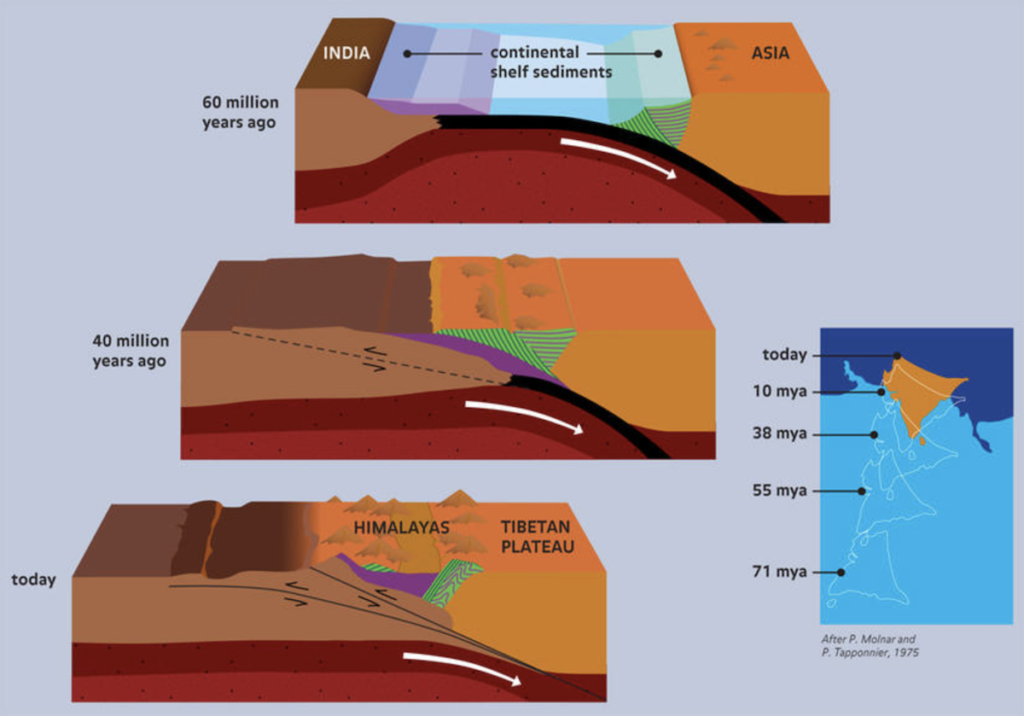
The Himalayas, a new folded mountain, resulted from the Eurasian Plate colliding with the Indian Plate during the Cenozoic Era. Sediments from the Tethys Sea between these plates underwent upheavals in various geological periods, forming three successive ranges:
- Greater Himalayas (Himadri): Formed during the Eocene Period (about 65 million years ago).
- Lesser Himalayas (Himachal): Formed during the Miocene Period (about 45 million years ago).
- Shiwaliks (Outer Himalayas): Formed during the Pliocene Period (about 1.4 million years ago).
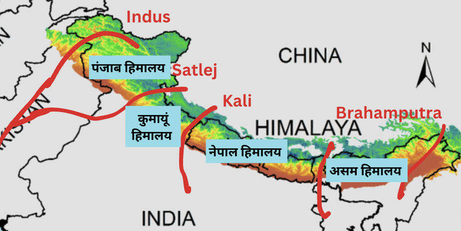
- The Punjab Himalayas-
- 560 km long stretch of the Himalayas between the Indus and the Satluj rivers
- Also called the Kashmir or the Himachal Himalaya.
- Karakoram, Ladakh, Pir Panjal, Zaskar, and Dhaola Dhar are the main ranges of this section.
- The 3,444 m high Zoji La pass provides an easy passage.
- In between the main contents, there are valleys, duns and lakes.
- The Kumaon Himalayas
- Between the Satluj and the Kali river ; 320 km long
- Western part is called Garwhal Himalaya and the eastern part is known as Kumaon Himalaya.
- Nanda Devi(Highest 7187), Kamet, and Trishul Badrinath Kedarnath Gangotri are important peaks.
- Source of rivers like the Ganga and the Yamuna.
- The Nepal Himalayas
- The Kali river to the Tista river; 800 km.
- Most of this Himalaya lies in Nepal hence it is called Nepal Himalayas.
- Mount Everest is the highest peak of the world. The other major peaks are Kanchenjunga, Lhotse I, Makalu, Dhaula Giri, Cho Oyu, and Annapurna.
- Kathmandu is a famous valley.
- The Assam Himalayas
- The Himalayan ranges from Tista to Brahmaputra rivers covering a distance of 750 km are called the Assam Himalayas.
- The important peaks of this region are Namcha Barwa, Kula Kangri, and chombo Lhari.
| Aspect | Western Coastal Plain | Eastern Coastal Plain |
| Location | Between Kutch and Kanyakumari | Between Swarnarekha River and Kanyakumari |
| River Mouth Type | Rivers form estuaries | Rivers form deltas |
| Major Rivers | Sabarmati, Mahi, Narmada, Tapi, Sharavati | Mahanadi, Godavari, Krishna, Kaveri |
| Width | Narrow (50–100 km) | Wide (100–150 km or more) |
| Terrain | Rugged and rocky | Flat and level |
| Rainfall Source | South-west monsoon | South-west and north-east monsoons |
| Soil Type | Laterite soil due to heavy rainfall | Alluvial soil due to river deposits |
| Farming Type | Commercial crops (e.g., mango, cashew, coconut) | Food crops (e.g., rice) |
| Lagoon Lakes | Found in the southern part | Found in the northern and central parts |
| River Utility | Rivers form waterfalls (hydroelectricity) | Rivers form deltas (navigation) |
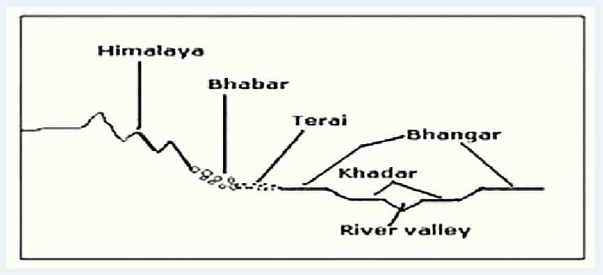
| Feature | Bangar | Khadar |
| Soil Type | Older alluvium (mature soil) | Newer alluvium (younger soil) |
| Location | Higher terraces above the floodplain (about 30 meters above flood level) | Lower areas close to river beds forming the floodplain |
| Composition | More clayey and generally dark-colored; contains beds of lime nodules known as “Kankar” | Sandy clays and loams; less calcareous and carbonaceous (less kankar ) |
| Fertility | Less fertile compared to Khadar | Highly fertile due to annual deposition of new alluvium |
| Flooding | Rarely affected by floods | Frequently affected by floods, with new layers of alluvium deposited each year |
| Examples | Found in the Doab regions (areas between rivers). For example- The Ganga- Yamuna Doab and the Plains of Satluj. | Found in the floodplains of rivers like the Ganges and Yamuna |
- Lakshadweep Islands are situated in the Arabian Sea, comprising 36 islands spread across 32 square kilometers between 8 N and 12 N latitude.
- Separated by narrow straits, they are part of the Reunion Hotspot volcanism and primarily made up of coral deposits.
- Main islands include Kavaratti, Agatti, Minicoy, and Amini.
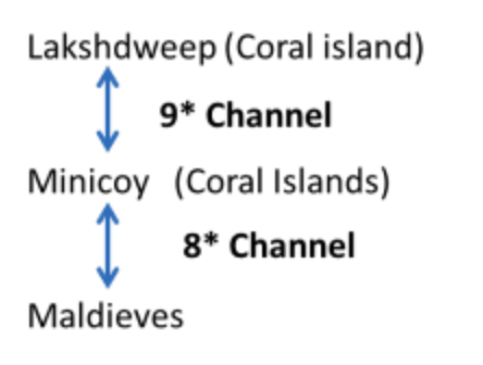
- Minicoy, the largest island, is separated from the Lakshadweep group by the 9 Degree Channel and from the Maldives by the 8 Degree Channel.
- Most of the islands have low elevation and do not rise more than five meters above sea level (Extremely Vulnerable to sea-level change).
- Their topography is flat and relief features such as hills, streams, valleys, etc. are absent
| Western Ghats | Eastern Ghats |
| Runs parallel to the western coast in a north-south direction from the Tapi River to Kanayakumari. | Runs in a north-east to south-west direction parallel to the eastern coast from Orissa to the Nilgiri hills. |
| Formed by subduction of Arabian basin and tilting of the peninsula → Block Mountain | Geologically Precambrian fold mountains |
| Continuous chains of mountains and can be crossed through passes only. | Not continuous and are cut by rivers falling into the Bay of Bengal. |
| Nilgiris, Annamalai, Cardamon, Palani | Nallamala, Palkonda, Javadi Hills and the Shevroy-Kalrayan Hills |
| The height ranges from 900-1600 meters; average width is 50 to 80 km. Highest peak – Anaimudi (2695 m) | Height is lower than the western ghats, height ranges from 600 to 900 meter; width varying from 100 to 200 km.Highest peak – Jindhagada peak (1690 meters) |
| Most of the Peninsular rivers originate from western ghats (Tungabhadra, Krishna, Godavari ) | No major river originates from Eastern ghats. |
| The soil is highly fertile. | The soil is not so fertile here. |
| Almost perpendicular to the south-west monsoons coming from the Arabian Sea and causes heavy rainfall in the west coastal plain. | Almost parallel to the monsoons coming from the Bay of Bengal and does not cause much rainfall. |
| One of the eight hotspots of biological diversity in the world | Less biodiverse compared to Western Ghats |
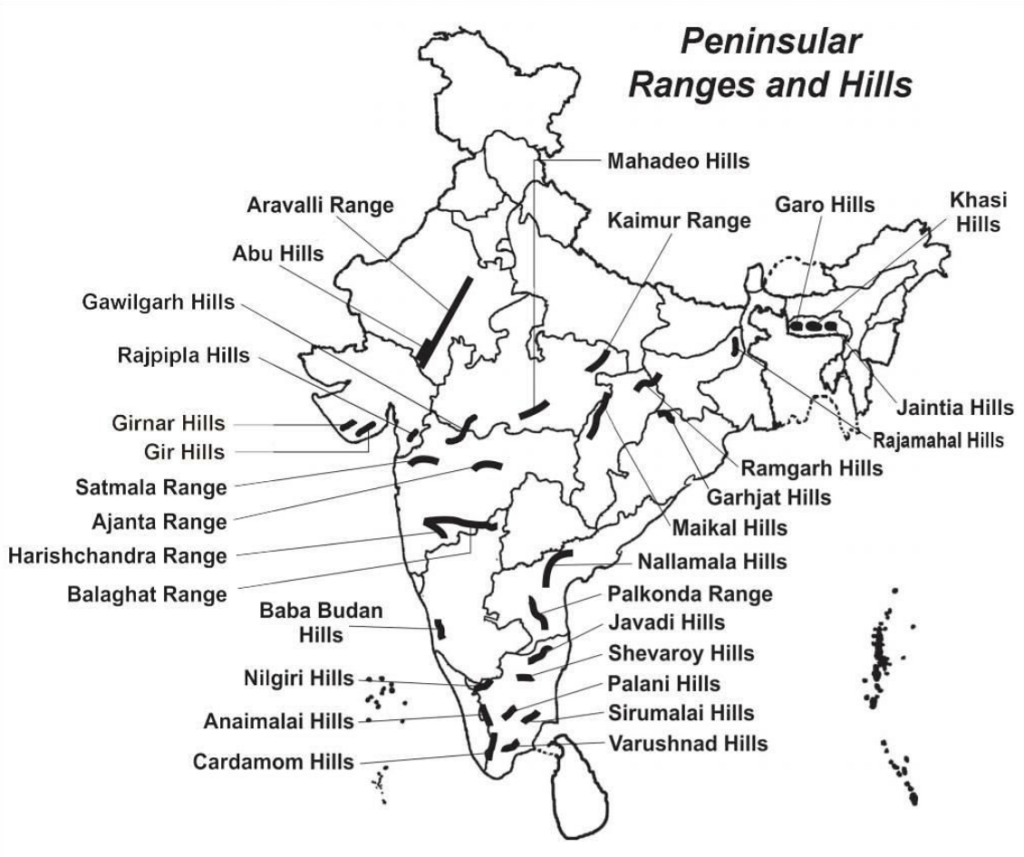
- This is one of the oldest and the most stable landmass of India. Delhi ridge in the northwest, (extension of Aravalis), the Rajmahal hills in the east, Gir range in the west and the Cardamom hills in the south constitute the outer extent of the Peninsular plateau. However, an extension of this is also seen in the northeast, in the form of Shillong and Karbi-Anglong plateau.
- Features 👍
- It covers a total area of about 16 lakh sq km ; irregular triangular shape
- Height : 600-900 m
- Made up of a series of patland plateaus such as the Hazaribagh plateau, the Palamu plateau, the Ranchi plateau, the Malwa plateau, the Coimbatore plateau and the Karnataka plateau, etc.
- General elevation of the plateau → from the west to the east ⇒ Flow of rivers along this
- Important physiographic features → tors, block mountains, rift valleys, spurs, bare rocky structures, series of hummocky hills and wall-like quartzite dykes
- Western and northwestern part ⇒ presence of black soil.
- Undergone recurrent phases of upliftment and submergence accompanied by crustal faulting and fractures. Eg. Bhima fault
These spatial variations have brought in elements of diversity in the relief of the Peninsular plateau.
The northwestern part : complex relief of ravines and gorges. Eg. ravines of Chambal, Bhind and Morena
- On the basis of the prominent relief features, the Peninsular plateau can be divided into three broad groups:
- The Deccan Plateau : This is bordered by the Western Ghats (Sahyadri, Nilgiri hills Anaimalai hills and Cardamom hills) in the west, Eastern Ghats (Javadi hills, the Palconda range, the Nallamala hills etc) in the east and the Satpura, Maikal range and Mahadeo hills in the north.
- The Central Highlands : It is bordered by the Aravalli Mountains in the west, the Satpura Mountains in the south and the Rajmahal Hills in the east. This part extends till Jaisalmer district where it is covered with longitudinal and arc-shaped (Barkhan) sandy dunes. Chhota Nagpur plateau is the main mineral deposit of this region. Most of the tributaries of Yamuna like Chambal, Betwa, Ken etc. originate from the Vindhyachal and Kaimur ranges of this region.
- The North-eastern Plateau.: The north eastward movement of the Indian plate caused a fault between Rajmahal hills and Meghalaya plateau, detaching the NE Plateau from the main Peninsular Block.
The Meghalaya plateau, divided into the Garo, Khasi, and Jaintia Hills, is rich in mineral resources like coal, iron ore, and limestone, and receives heavy rainfall from the southwest monsoon, resulting in highly eroded surfaces.
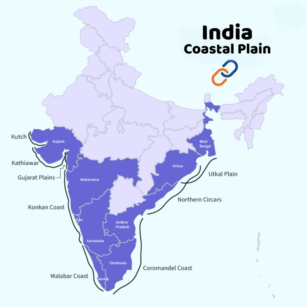
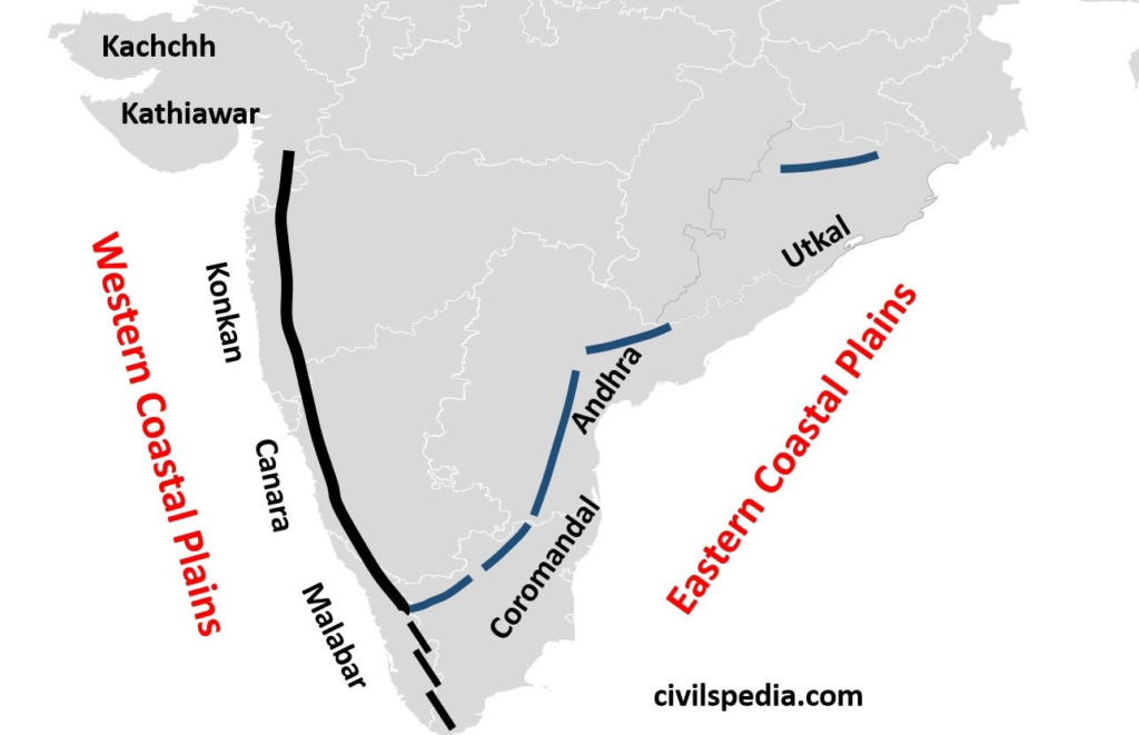
Sub-divisions of Coastal Plains in India:
Western Coastal Plains | Eastern Coastal Plains |
Subdivisions of Western Coastal Plains:
|
Subdivisions of Eastern Coastal Plains:
 |



