

Aditya-L1, the first Indian space-based observatory to study the sun, was launched on September 2, 2023, from the Satish Dhawan Space Centre in Sriharikota using the PSLV C57 rocket. Recently, it was successfully placed in a halo orbit around the L1 Lagrangian point. .
Objectives
- Study of Solar upper atmospheric (chromosphere and corona) dynamics
- Physics of coronal heating mechanisms and reasons behind extreme temperatures.
- Understanding the initiation and dynamics of Coronal Mass Ejections (CMEs)
- Investigation into the magnetic field of the solar corona and its role in driving space weather.
- Examination of particle acceleration on the Sun leading to solar wind generation.
- Identify the sequence of processes that occur at multiple layers (chromosphere, base and extended corona) which eventually leads to solar eruptive events.
Understanding solar phenomenon: it Carries seven payloads (SUIT, PAPA, HEL1OS, VLEC etc) to observe the photosphere, chromosphere, and corona using electromagnetic and particle detectors.
- Understanding the solar corona’s dynamics is crucial for comprehending solar variability and its impacts on Earth’s climate.
- Capturing Full disk image of the Sun : by Observing UV radiation from different solar atmosphere zones.
- Discern the roles of natural and anthropogenic factors in climate change.
- Observing the Sun 24X7 : Aditya-L1 continuously views the Sun without occultation or eclipse, allowing unobstructed observation of solar activities
- functions as a space weather station : Data from Aditya L1 aids in predicting geomagnetic storms and understanding space weather dynamics, crucial for protecting satellites and space assets.
- Advancing solar physics and Enhancing nuclear fusion energy research.
- Objective: The Gaganyaan project aims to demonstrate human spaceflight capability by launching a crew of three members into an orbit of 400 km for a three-day mission and safely bringing them back to Earth by landing in the Indian sea waters.
- Two unmanned missions precede the final manned mission for safety. The first unmanned test flight (Gaganyaan-1 mission) is scheduled by 2024.
- Launch vehicle: The Human Rated LVM-3 (GSLV Mk III) → ISRO has reconfigured all components of LVM3 to meet human rating requirements.
- Orbital Module (OM): It will orbit Earth, comprising the Crew Module (CM) and Service Module (SM).
- Tests Planned :
- Integrated Air Drop Test (IADT): Indian Air Force drops a 5-ton dummy crew module.
- Pad Abort Test (PAT): Ensures quick escape from rocket in case of failure.
- Crew Abort Test Mission: Simulates abort conditions during ascent.
- Vyomitra: Humanoid robot for microgravity experiments and monitoring.
- Manned Flight: Final mission with human astronaut, landing in the Arabian Sea off Gujarat.
Aspect | Geostationary Orbits | Sun synchronous Orbits |
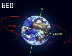
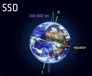
Synchronization | Satellites in geostationary orbit (GEO) circle Earth above the equator from west to east, matching Earth’s rotation speed, making them appear stationary over a fixed position. | Sun-synchronous orbit (SSO) is a polar orbit where satellites travel over the polar regions, remaining synchronized with the Sun. This ensures they consistently pass over the same spot at the same local time. |
Altitude | At an altitude of 36000 km. | At an altitude of 500 km-800 km. |
Application | Communication satellites and Weather studies. | Earth observation, remote sensing, climate monitoring ( predict storms and monitor forest fires and floods) |
Examples | INSAT Series, GSAT Series, IRNSS/NavIC | Cartosat Series, RISAT Series, ResourceSat Series |
 |  |
Satellite internet is a type of internet service that utilizes satellite communication technology to provide internet access to users.
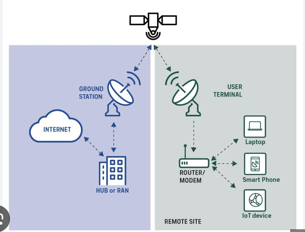
- Instead of using traditional terrestrial infrastructure like cables or fiber-optic lines, satellite internet relies on satellites orbiting the Earth to transmit data between the user’s location and the internet service provider’s (ISP) ground station.
- Components–
- Satellite in low- or high-Earth orbit;
- Ground stations which are gateways to relay the data from and to the satellite;
- Dish antenna with transceiver, which is provided at the user’s premises.
- Recently announced Reliance JioSpaceFiber: India’s first satellite-based gigabit broadband service; Elon Musk’s Starlink
- JioSpace Fiber uses medium Earth orbit (MEO) satellites, while Starlink uses low Earth orbit (LEO) satellites.
Advantages- Global coverage, Easily Scalable, More Secure, Reliable communication, Low Latency.
Disadvantages– High cost, Risk of Debris, Signal Interference due to Weather Latency: Limited bandwidth: Coverage gaps leading to signal attenuation.
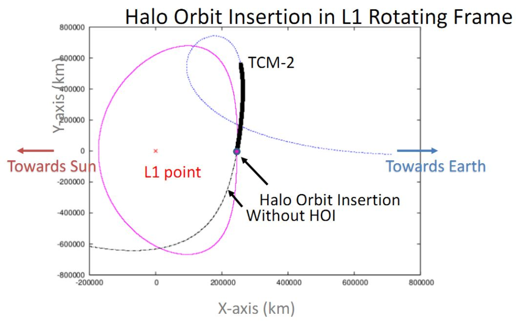
Recently ISRO has achieved a significant milestone by placing the Aditya-L1 spacecraft in a halo orbit around the Lagrangian point (L1).
Halo Orbit:
- Halo orbits are three-dimensional, periodic orbits around Lagrange points in a two-body system like Earth-Sun or Earth-Moon.
- It is commonly linked with L1, L2, and L3 Lagrange points, where the gravitational forces of two large bodies and centrifugal force balance each other.
- The use of a halo orbit minimizes fuel consumption while ensuring a continuous view of the Sun for the Aditya-L1 mission.
- The James Webb Space Telescope utilizes a halo orbit around the Earth-Sun L2 point for stable observation.
Navigation with Indian Constellation (NavIC) : developed by ISRO to meet the positioning, navigation, and timing requirements of India. It was Formerly known as Indian Regional Navigation Satellite System (IRNSS).
- Constellation Composition: Consists of 7 satellites and a network of ground stations operating 24 x 7. Three satellites in geostationary orbit and Four satellites in inclined geosynchronous orbit
- Services Offered: provide two types of service
- Standard Position Service (SPS) for civilian users.
- Restricted Service (RS) for strategic users.
- Coverage Area:Includes India and a region up to 1500 km beyond the Indian boundary.
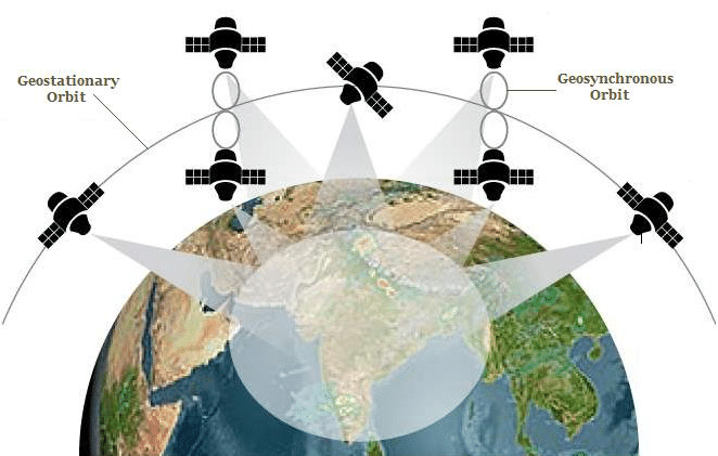
Significance for india:
- Global Recognition: Endorsed by IMO, positioning India as fourth globally to have regional satellite system
- Strategic Autonomy: Reduces reliance on GPS, ensuring independence. (Denial of GPS data during kargil war 1999)
- Socio-Economic Impact:Enables navigation for disaster Management, Vehicle tracking and fleet management, Precise Timing, Mapping and Geodetic data capture etc
- Accuracy and Reliability: NavIC uses dual frequencies (S and L bands) for enhanced accuracy. It offers 5-20 meters precision for general users and 0.5-5 meters for military applications.
- Civil Aviation Support: GAGAN system improves aviation navigation.
- Defense Enhancement: Provides accurate data during hostilities.; Supports modern weapon systems.
- Coverage in Remote Areas: Extends coverage to inaccessible regions by Utilizing high geo-stationary orbit satellites.
- Manufacturing Ecosystem: NavIC-enabled chipsets may become standard in all mobile phones in India, replacing GPS.It will boost the mobile telecom industry.
(Extra → NavIC support to become must for all smartphones : While 5G phones will need to provide mandatory support for NavIC by January 1, 2025, all other phones operating in the L1 band that currently use the Global Positioning System (GPS) will need to provide mandatory NavIC support by December 2025)
Satellite Communication
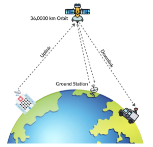
- Modulated carrier waves are sent to a satellite, amplified, and retransmitted to Earth at a different frequency.
- Satellites amplify the signal and avoid interference by transmitting at different frequencies.
- Medium of Communication: Communication is carried out through radio or microwave signals.
- Working of Communication Satellites
- Signal Transmission (Uplink): Signals are sent from an Earth station to the satellite.
- Signal Amplification (Transponder): The satellite receives the signal and boosts it to ensure it’s strong enough for transmission.
- Signal Transmission (Downlink): The satellite retransmits the signal back to Earth.
- Signal Reception: Ground stations or antennas on Earth receive the signal and process it.
- Launch Vehicle Mark-III (LVM3) : a three-stage medium-lift launch vehicle developed by Liquid Propulsion Systems Centre of ISRO.
- Previous Name: Geosynchronous Satellite Launch Vehicle (GSLV) Mark-III
- Payload Capacity:
- Capable of placing 4 tonne class satellites of the GSAT series into Geosynchronous Transfer Orbits (GTO).
- Can handle 8 tonne heavy payloads into Low Earth Orbits (LEO) of 600 km altitude.
- Stages of LVM3:
- First Stage: Consists of two S200 boosters strapped to the sides of the rocket body.
- Second Stage: L110 liquid stage powered by two Vikas engines.
- Uppermost Final Stage: Powered by a cryogenic engine. Combusts liquefied hydrogen with liquefied oxygen.
- Some of the LVM 3 Missions launched are,
- Chandrayaan-3 Mission, Chandrayaan-2 Mission
- OneWeb India-2 Mission, OneWeb India-1 Mission
- GSAT-29 Mission, GSAT-19 Mission, CARE Mission
India made history by becoming the first country to land on the lunar south pole and the fourth country to place a rover on the moon with its Lunar Mission “Chandrayaan 3” on August 23, 2023.
| Objectives | Previous Missions | Chandrayaan-3 |
| Safe and Soft landing | Chandrayan 2 failed (crash landing of Vikram lander ) | Demonstration of a Safe and Soft Landing on the Lunar Surface |
| Roving on the lunar surface | rover Pragyan could not be deployed | Deployed the rover to explore the cratered surface |
| Conduct in-situ scientific experiments. | Could not perform. | Underway ⇒ All payloads are performing normally. |
| Exo-Planet Research | Not focussed | Propulsion Module has a payload → SHAPE |
| Technology Validation | Limited to soft landing | HOP experiment : Future possibility of coming back from the moon. |
Major Subsystems :
- Chandrayaan-3 consists of an indigenous Lander module (Vikram), Propulsion module (PM) and a Rover (Pragyan) with an objective of developing and demonstrating new technologies required for Interplanetary missions.
- Scientific Instruments:
| Propulsion Module Payload:SHAPE : Explore smaller planets in reflected light for habitability and potential presence of life. |
| Lander Payloads:RAMBHA : Measure near-surface plasma density and its changes over time using Langmuir probe (LP).ChaSTE : Measure thermal properties of the lunar surface near the polar region.ILSA : Measure lunar seismic activity and delineate lunar crust and mantle structure.LASER Retroreflector Array (LRA) : Passively study dynamics of the Moon system. |
| Rover Payloads:LIBS: to derive the chemical composition of the moon surfaceAPXS : Determine elemental composition((Mg, Al, Si, K, Ca,Ti, Fe) of Lunar soil |
Significance of this achievement for india
- Joins the elite Group: India became the fourth country to master the technology of soft-landing on the moon’s surface after the US, China, and the former Soviet Union.
- India as a space exploration player :we will be part of all decision-making related to future planetary explorations and even extraction of resources from space.
- Entry into the moon economy : Space Tourism and Economic Opportunities
- Technological Advancement: from altimeters to hazard detection systems : The knowledge obtained from this mission will assist future launches, including Shukrayaan, Gaganyaan, and Aditya-L1.
- Unleashing Scientific Discoveries: provided vital data about the lunar surface, including the presence of sulphur and other minor elements, as well as surface temperature. → implications for lunar resource utilisation and future habitation plans.
- Strategic and Geopolitical Significance : Two competing Moon projects are already at hand, one led by China and Russia, and another by the US. India signed the Artemis Accords in July 2023, signalling its participation in the new space race to build permanent infrastructure on the Moon.
In conclusion, Chandrayaan-3’s endeavors mark significant milestones for India’s space exploration journey. From showcasing technological prowess and leadership in space to unraveling the mysteries of celestial bodies like the Moon.
The Gaganyaan Mission is India’s inaugural human spaceflight initiative, developed by the Indian Space Research Organisation (ISRO). It aims to propel a crew of three astronauts into a 400 km low Earth orbit (LEO) for a mission lasting up to seven days, culminating in a safe return to Earth. It will make India the fourth country to conduct independent human spaceflight after the USA, Russia, and China.
Strategic Objectives of Gaganyaan Mission
- National Prestige: To enhance India’s global status as a space power; aligns with “Aatmanirbhar Bharat” in advanced technology.
- Technological Self-Reliance: Development of indigenous technologies like GSLV Mk III (LVM3), crew escape systems, life support, and re-entry modules.
- Foundation for Future Space Exploration Missions: Supports plans for an Indian space station by 2035, future deep space missions and crewed interplanetary missions.
- Space Diplomacy and International Collaboration: To enhanc space diplomacy and collaboration with agencies like Roscosmos and NASA.
- Defense and Security: Dual-use technologies like re-entry control and tracking systems enhance aerospace capabilities.
- Economic and Innovation Boost: Sparks scientific temperament, boosts STEM education, and creates high-tech job opportunities.
Technological Challenges of the Gaganyaan Mission
- Crew Safety: Ensuring safe launch, orbital travel, and re-entry with Gaganyaan’s Human-Rated Launch Vehicle (HRLV).
- Life Support Systems: Developing reliable Environmental Control and Life Support Systems (ECLSS).
- Re-entry Heat Shield: Crafting thermal protection to withstand 2000°C temperatures during re-entry.
- Astronaut Training and Recovery: India lacks major space training and simulation facilities for manned missions. Hence India’s dependence on other space agencies or countries (America and Russia) for such facilities.
- Radiation and Microgravity Management: Ensuring astronaut health in the space environment.
Alignment with India’s long-term goals in space exploration
- Lays foundation for space station by 2035, deep space missions, and international collaborations.
- Supports ISRO’s vision for Atmanirbhar Bharat in space tech and aligns with projects like Chandrayaan-3 and Aditya-L1.
- Encourages participation in the global space economy and future Moon-Mars missions.
Gaganyaan is a strategic leap in India’s space journey, bridging present ambitions with future exploration.
India’s lunar exploration journey, led by the ISRO, has evolved from initial exploratory missions to achieving significant milestones in lunar science and technology. These missions have not only enhanced India’s scientific stature but also contributed meaningfully to global lunar exploration.
Evolution of India’s Lunar Missions
- Chandrayaan-1 (2008):
- Mission Type: Orbiter and Impact Probe.
- Objective: India’s first lunar mission to explore the Moon’s surface.
- Achievements: Discovered water molecules on the Moon’s surface, which was a breakthrough in lunar science.
- Chandrayaan-2 (2019):
- Mission Components: Orbiter, Vikram Lander, Pragyan Rover.
- Objective: Aimed to achieve a soft landing near the Moon’s south pole.
- Achievements: Although the lander (Vikram) failed to land successfully, the orbiter continues to send data, furthering lunar exploration.
- Chandrayaan-3 (2023):
- Mission Components: Lander (Vikram) and Rover (Pragyan).
- Launched on 14 July 2023, First successful soft-landing near lunar south pole on August 23, 2023.
- Achievements:
- Confirmed presence of sulfur and other elements on the lunar surface.
- Conducted in-situ measurements of lunar surface temperature and seismic activity.
- Chandrayaan-4 (Future Mission): This ambitious project aims to achieve a soft landing on the Moon, collect lunar rock samples, and return them to Earth.
Contribution to Global Lunar Exploration
- India’s lunar missions have provided unique scientific data, particularly from regions previously unexplored.
- The successful landing of Chandrayaan-3 in the south pole region has opened new avenues for studying lunar geology and the potential presence of water ice, which is crucial for future lunar missions.
Enhancement of India’s Scientific Stature
- These missions have positioned India as a key player in space exploration, showcasing its technological capabilities and commitment to scientific advancement.
- The success of Chandrayaan-3, in particular, has bolstered national pride and demonstrated India’s growing prowess in space technology.
India’s lunar missions have significantly contributed to global lunar exploration, advanced scientific understanding, and enhanced India’s position as a key player in space exploration.
- PSLV is often called the “workhorse” of the ISRO due to its reliability, versatility, and global success.
- High Success Rate: Over 50 successful missions since 1994, establishing its reliability.
- Multi-Satellite and Multi-Orbit Capability: PSLV is capable of launching multiple satellites in a single mission into different orbits. Launched 104 satellites in one go (2017).
- Versatile Payload Capacity: Capable of launching satellites into multiple orbits (SSO, GTO, LEO).
- Commercial Success: Used for foreign satellite launches like Amazonia-1.
- Played a crucial role in India’s interplanetary missions: Chandrayaan-1 (2008) – Moon mission, Mangalyaan (2013) – First Mars mission on maiden attempt.
- Cost-Effective: Offers low-cost launch services, attracting international clients.
- ISRO’s SPADEX (Space Docking Experiment) mission included two small satellites designed to demonstrate India’s first-ever in-space docking experiment.
- Strategic Importance
- Technological Advancement: Enables mastering of complex technologies like autonomous rendezvous and docking.
- Space Station Capability: Paves the way for India’s own space station by 2035.
- Human Spaceflight Support: Crucial for Gaganyaan and future crewed missions for rescue, refueling, and repair.
- Defense and Security: Enhances capabilities in satellite servicing and space situational awareness.
- Global Competitiveness: Aligns India with advanced spacefaring nations like the USA, Russia, and China.
- Strategic Importance
Docking Achievement: On January 16, 2025, the two spacecraft, designated as “Chaser” and “Target,” successfully docked, making India the fourth nation to achieve in-space docking.
Remote sensing is the process of detecting and monitoring the physical characteristics of an area by measuring its reflected and emitted radiation at a distance (typically from satellite or aircraft).
Starting with IRS-1A in 1988, ISRO has launched many operational remote sensing satellites.
- Cartosat Series (1, 2, 2A, 2B): Provides land topography data and develops geographical maps.
- Oceansat Series : Dedicated to oceanography and mapping ocean topography.
- Resourcesat Series : Meant for resource management, such as mineral and forestry resources assessment.
- EOS series : Designed to provide high-quality images for resource management under all weather conditions.
- RISAT Series : Disaster Management System, Earth Observation
- SARAL : Climate & Environment, Earth Observation; Hysis.
- NISAR will map the globe in 12 days, offering consistent data for analyzing changes in Earth’s ecosystems, ice mass, vegetation, sea levels, groundwater, and natural hazards like earthquakes, tsunamis, volcanoes, and landslides.
Application of Remote sensing in India (By Isro and other agencies )
- Land Management and Planning: National Land Use/Land Cover mapping on 1:250,000; Re-assessment of basin scale water resources using Space inputs
- Agricultural Planning and Management: Crop Acreage and Production Estimation; Project CHAMAN (Horticulture)
- Forest and Environmental Conservation: Indian Forest Cover Change Alert System (InFCCAS); Study on Sundarban mangrove system; Monitoring and Assessment of ecosystem process in North Western Himalayas
- Water Resource Management: Inventory and Monitoring of Glacial Lakes/Water Bodies; Assessment of Irrigation Potential Utilisation (I.P.U) using geospatial data; Spatial modelling of fluoride contamination in groundwater
- Infrastructure Planning and Management: Monitoring of Gas Pipelines; Island Information System (IIS)
- Climate Change and Disaster Management: Study on Sundarban mangrove system; Monitoring and Assessment of ecosystem process in North Western Himalayas.



