
In Rajasthan Geography, Rajasthan’s physiographic divisions—Aravalli Range, Thar Desert, and Eastern Plains—shape diverse landscapes and climate. From Udaipur’s hills to Jaisalmer’s deserts, they define settlement patterns.
Previous Year Question
|
Year |
Question |
Marks |
|
2018 |
Describe the main physical characteristics of Shekhawati region. |
5 M |
|
2013 |
What makes Western Rajasthan an extreme drought affected area of India ? |
2 M |
|
2013 |
Give the characteristics of ‘Dang region’ of Rajasthan. |
2 M |
|
2013 |
Portray the geographic-cultural identity of Shekhawati region of Rajasthan. |
5 M |
|
2021 |
Discuss the physical features of the Hadoti plateau of Rajasthan. |
5 M |
Introduction
Rajasthan is the largest state in the Union of India and has more physical variations than any other state. It has regions of rolling sand dunes in the west to lofty rocks in the middle to fertile plains in the east.
On the basis of the existing relief features, there are following physical divisions of Rajasthan:
- Northwestern desert Region
- Aravalli Range And Hilly Region
- Eastern Plains
- South-eastern Plateau (Hadoti Plateau)

| Rajasthan’s four physical regions based on relief and climate | |||||
| Northwestern desert | Aravalimountain | Eastern Plain | Hadoti Plateau | ||
| Arid | Semi-arid | ||||
| Area % | 61 | 9 | 23 | 7 | |
| Population (%) | 40 | 10 | 39 | 11 | |
| Districts (OLD) | 12 | 13 | 10 | 7 | |
| Soil | Sandy soil | Mountain soil | alluvial | Light black/cotton | |
| Rainfall | 0-20 cm | 20-40 cm | 40-60cm | 60-80 cm | 80-120 |
| Climate | Arid and semi arid | Sub humid | humid | Maximum humid | |
| Vegetation(Koppen) | Xerophytes& thorny | Steppe(Largest) | Dry deciduous | Dry and wet | Savana (vagad hadoti +Mt abu) |
North – Western Desert Region
- Origin :-
- The Tethys Sea covered western Rajasthan during the Permo-Carboniferous period.
- During the Jurassic, Cretaceous, and Eocene eras, this region remained submerged under the sea.
- The Quaternary epoch-Pleistocene period witnessed the emergence of humans after the sea receded.
- By 4000–1000 BCE, the region transformed into a full desert.
- The salt water lakes present here are considered to be the remains of oceans.
- According to Sir Cyril Fox, the south-western part of the desert and the lower valley region of Sindh remained under the sea during the Upper Tertiary period. This fact is evident from the marine fossils found in the rocks.
- Area:
- Covers 61% of Rajasthan’s total area, making it the largest physical region in Rajasthan, spanning 2.10 lakh sq. km.
- Earlier, it covered 58% of Rajasthan, but the desert is expanding eastward due to fragmentation of the northern Aravalli range.
- Dimensions:
- Length: 640 km.
- Width: 300 to 360 km.
- Districts Covered (12):
- Northern districts: Shri Ganganagar, Hanumangarh.
- Central districts: Churu, Jhunjhunu, Sikar, Nagaur, Jodhpur, Pali.
- Western districts: Jalore, Barmer, Jaisalmer, Bikaner.
- Population Settlement:
- Hosts 40% of Rajasthan’s population.
- However, it has the lowest population density in the state due to arid conditions.
Characteristics
- Temperature :- 49℃(summer) to -3 ℃ (winter)
- Rainfall :- 25 cm to 50 cm annually (Rain shadow area of Aravalli)
- Climate :- Arid and semi-arid type of climate is found.
- Soil :- Sandy soil.
- Slope :- East to West and North to South (NE to SW)
- Major rocks :- Sedimentary rocks.
There are vast expanses of sand & rock outcrops mainly limestone are found in Jaisalmer, Barmer, Bikaner, Churu, Hanumangarh & Sriganganagar.
- Vegetation :- Xerophytes and thorny bushes,cactus, date palm.
- Agriculture :- Mainly Kharif crop is produced in large quantities; main crops are Bajra(pearl millet) Moth and Guar
- 25 cm isohyet divides it in two parts (divided into two major regions and 6 sub-regions)

Great Indian desert
- The desert covers about 85% of the total area
- This is the region spread between the Radcliffe line (Indo-pak border) and the 25 cm isohyet line
- The Thar Desert is also termed as the ‘Great Indian Desert’ because this desert ranks first in the world in terms of population, population density and biodiversity.
- Desert is also called the Powerhouse of the World due to its rich energy resources. Here, favourable conditions for conventional energy resources (coal, petroleum, natural gas) and non-conventional energy resources (solar energy, wind energy, biogas) are found.
- Tertiary period sedimentary rocks are predominant in which deposits of fossil minerals like coal, petroleum, natural gas, limestone etc. are found.
- Rainfall less than 25 cms annually
- Districts- Bikaner, Barmer, Balotra, Jaisalmer, Jodhpur, Nagaur, Churu
- Area – 120500 Sq. Km (Thar Desert)
- Height of sand dunes – 6 m to 60 m
- Length of sand dunes – 3 km to 5 km
- Towards west of it is the sandy arid desert Marushthali also known as the Thar Desert.

- March of the Desert :- The process of desert advancement or expansion of desert is called March of Desert or desertification for which Nachana village of Jaisalmer is famous. The Indian desert is expanding towards Delhi, Haryana, Uttar Pradesh and Madhya Pradesh.
- Shifting sand dunes is locally termed Dharians.
- Divided into two parts
- Sand dune region (58.5%)
- Dune free region (41.5%)
Sand dune region
- Types of sand dunes-
- Sand dunes are geographical structure formed by deposition of fine soil by wind
- Majority six types of sand dunes are found in Rajasthan
- Barkhan sand dunes (Barchans)–

- Shape: Semicircular dunes; the term “Barkhan” is derived from Turkish, meaning “semicircle.”
- Features:
- Windward side (convex slope): Faces the wind and has a gentle slope.
- Leeward side (concave slope): Faces away from the wind and has a steeper slope.
- Mobility: Highly mobile, leading to significant desertification.
- Maximum Expansion: Shekhawati region, particularly in Churu.
- Transverse sand dunes–

- Shape: Formed at right angles (perpendicular) to the wind direction due to obstructions in the wind’s path.
- Features: Prominent ridges aligned across the wind flow.
- Maximum Expansion: Jodhpur, and parts of Rawatsar (Hanumangarh), Suratgarh (Sri Ganganagar), Churu, and Jhunjhunu.
- Longitudinal sand dunes (Linear Dunes) –

- Shape: Long and narrow, aligned parallel to tAhe wind direction.
- Features: Stretch over long distances in the direction of prevailing winds.
- Maximum Found: Jaisalmer region.
- Star shaped sand dunes –

- Shape: Multi-armed dunes resembling stars, formed when sand dunes converge from various directions.
- Features: Created by wind action from multiple directions.
- Found In: Mohangarh, Pokhran (Jaisalmer), Suratgarh.
- Parabolic sand dunes –
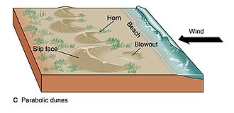
- Shape: U-shaped dunes, with their open end facing the wind (opposite to Barkhan dunes).
- Features:
- Windward side: Erosion due to wind creates the U-shape.
- Leeward side: Vegetation around the dunes makes them more stable compared to other types.
- Most Commonly Found In: Almost all districts, especially Bikaner.
- Coppice Sand dunes (Shrubs coppice) –

- Shape: Small, moon-shaped dunes formed at the base of shrubs and bushes.
- Features:
- Smallest type of dunes in the desert.
- Formed due to wind depositing sand around vegetation.
- Found In: Scattered across the Thar Desert.
- Obstacle Dunes – These dunes are formed due to an obstruction (such as a hill or other barrier). Major Locations: – Pushkar, Budha Pushkar, Nag Pahad, Beechun Pahad, Jobner and Sikar Hills
- Seif Dunes – During the formation of Barchans, when the wind direction changes, one arm of the Barchan extends forward, forming a structure known as a Seif dune.
- Network Dunes – These dunes are found in the northeastern part of the desert. Major Extension Area: From Hanumangarh to Hisar (Haryana).
- They occur in various forms:
- Sand Sheets
- Sand Hammocks
- Less organized dunes
- They occur in various forms:
Dune free region
- The Dune free region is made of sedimentary rocks (lime and sandstone)
- Underground water (Lathi series)is found, Oil and gas reserves are in abundance and Rann is also found.
- Chandan Tube Well (Pot of Thar), and Kuldhara are notable sites.
- Lathi series – There is an underground water belt spread over an area of 80/64 km from Jaisalmer (Pokhran) to Mohangarh.
Scientists consider it to be the remains of the ancient Saraswati river. Nutritious and tasty grasses like Sevan( leelan), Dhaman, Karad etc. grow here.Most of the Godavan bird population is found in this region(often termed as refuge/shelter of Godawan bird)
- Akal Village Wood Fossil Park – This is a fossil park located in Akal village in National Desert Park, Jaisalmer. Remains of natural vegetation of the Jurassic period are found here.Ancient vegetation and wood fossils are present here.
- Kuldhara – from this village of Jaisalmer, remains of whales have been found.
- Rajasthan’s first cactus garden has been established in this village.
- Hammada – Rocky/Stoney Desert. Extend in Pokhran (Jaisalmer), Phalodi (Jodhpur), Balotra (Barmer)
- Reg – This is a mixed desert found around Hammada, it is found in Jaisalmer, Barmer, Jodhpur
- Erg :- It is called the complete desert and the great desert. It is spread in Jaisalmer, Barmer, Bikaner, Nagaur, Churu, Sikar, Jhunjhunu etc.
Semi arid Desert region / Rajasthan Bangar
- Commonly known as Bangar region, with average annual rainfall 25 to 50 cms
- transition land between arid and semi humid area
- This region is spread between the dry sandy plain and the Aravalli mountain region.
- The 25 cm isohyet line determines the western boundary of the semi-arid region. Whereas the 40 cm isohyet line determines the eastern boundary.
- It is further divided into four regions
- Ghaggar plain
- Shekhawati Inland drainage Region
- Nagaur Highland
- Luni basin (godward region)
1. Ghaggar plain
- Called as Naali/Paat area
- Formed by alluvial soil brought about by Ghaggar river (dead river) Saraswati, Sutlej and Chautang rivers
- Extended over Sriganganagar and Hanumangarh
- In ancient times, this region was known as Yaudheya Pradesh because it was the residence of the Yaudheya caste.
- Nali – The plain area formed by the Ghaggar river in Hanumangarh is called Nali in the local language.
- Ghaggar Doab region
Doab – The fertile plain area situated between two rivers meeting at a place is called Doab.The fertile land between Sutlej and Ghaggar rivers is known as Ghaggar Doab region.
According to the report of Rajasthan Agriculture Department, a special type of soil is found in Ghaggar Doab region of Rajasthan which is known as Reverina soil. This soil is mainly found in Sri Ganganagar. Maximum wheat is produced in this soil.
- Loamy fertile soil called as Kathi soil
- Over irrigated area, Which causes problems of Alkalinity.
- Due to Ganga Canal and Indira Gandhi Canal, the area has become full of greenery, but this area is suffering from problems of alkalinity, acidity, water logging and desertification.
- Due to seepage of underground water around the Indira Gandhi Canal area, the upper layer of the earth’s surface becomes marshy, which increases the amount of salinity in the soil. Sri Ganganagar and Hanumangarh are the most affected districts. To solve the problem, an Indo-Dutch scheme is being run with the cooperation of the Netherlands.
2. Shekhawati Inland drainage Region
- Called as Bangar region
- Extends in Churu, Sikar, Jhunjhunu and North Nagaur (from north of the Luni river basin up to the north-eastern border of Rajasthan which includes Churu, Jhunjhunu, Sikar and the northern part of Nagaur)
- Major rivers flowing through this region are Kantli, Mentha, Khari, Rupangarh (which are rivers of inland drainage)
- The flow area of Kantali river is called ‘Torawati’. The hills of this area are called ‘Torawati Hills’.
- Due to relatively high rainfall in this region, vegetation grows on sand dunes. Mostly barkhan sand dunes are spread here, but longitudinal and discontinuous sand dunes are also found
- Barkhan- sand dunes are found in abundance
- Johar/Nada – wells Constructed for water conservation
- Sar/Sarovar – water bodies formed by water accumulation between sand dunes examples- Jassusar, Mansar, Salisar
- Many saline depressions (Ranns) are also found here, of which Didwana, Degana, Sujangarh, Talchappar, Parihara, Kuchaman etc. are notable.
- Beed-In Shekhawati region, public places of grasslands or pasture land reserved for animal grazing are called ‘Beed’.

3. Nagaur Highland
- Sandy barren areas free from sand dunes Extending in Nagaur and Ajmer.
- This region is a 300 to 500 meter high land region.
- This region is a highland area separate from the Aravalli mountainous region.
- Inland water drainage is found mainly.
- Some salty lakes in the eastern parts of this region are Sambhar, Didwana, Nawa, Kuchaman.According to Professor H.S. Sharma, some geologists have described these lakes as the remnants of the Tethys Sea, which is a false fact because sea water contains magnesium while the water of these lakes lack magnesium.
- Source of salt in there lakes-
- The micaceous salty rocks found beneath the soil from which the salt comes to the surface by capillary action which then turns into sodium chloride after evaporation.
- During the rainy season, small rivers collect salt particles along with water and bring them here (inland drainage)
- Soil contains excess sodium chloride, so it’s unfit for agriculture (barren)
- Hump belt/kubad patti – Due to evaporation of salty water salt gets accumulated in pits which have high content of fluoride salts in it. The hump belt is found between the borders of Nagaur-Ajmer but the area from Jayal to Pushkar is most affected. Due to excess fluoride in water, hunchback is seen among the residents here.Fluorosis disease is very commonly seen in local residents , in which teeth become yellow, bones become crooked, back bends due to which people develop humps, hence it is called Hump Belt/Banka Patti/Hoch Belt.
4. Luni Basin (Godwad region)
- Extends from Jodhpur, Jalore, Pali, Balotra & Barmer.
- Alluvial plain Formed by Luni river and its tributaries,Which is called ‘Luni Basin’ or ‘Luni Jawai Basin’. Salinity is also visible on land in some areas adjacent to the Rann of Kutch.
- Soil – New alluvial soil which covers 47.51 percent of the entire luni basin.
- It is spread over 35,000 sq km.
- Most humid region of Western Rajasthan
- Main canal of Luni basin – Narmada Canal
- The entire area of this region is plain, but some solitary hills are also located in this region, the main ones of which are as follows
- Chappan Hills – Circular hills about 11 km long and 1.5 km wide are spread from Mokalsar village to Siwana in Balotra. Being a group of 56 hills, they are called ‘Chhappan ki Paharis’. Granite is found in abundance in it, hence it is also called ‘Granite Mountain’. Peeplood (Balotra)- It is called the Mount Abu of the desert or the Little Mount Abu of Rajasthan. It is the place with the highest rainfall in western Rajasthan. The temple of Haldeshwar Mahadev is situated in Peeplood
- Jalore -Siwana Hills are famous for Granite reserves (Jalore is called Granite City) Hills made of granite and hills of Malani rhyolite are found in the form of domes and inselbergs. These are spread up to Mandalia, Hemawas, Ravaniya, Chotila, Khejarla, Kakni, Mogra Khurd
- Malani Hills– famous for limestone reserves.
- Nakoda Hills (Balotra) – This is a religious place of Jainism, Parshvanath temple is built here, which is known as Nakoda Bhairava.
- Sendra Hills (Beawar) – Rocks of various shapes including serpentine are found in Sendra (Beawar). There is a possibility of a rock garden.
- Run of Nehra (Neerhad)- after Balotrat that part of Barmer and Sanchore district which touches Kutch of Gujarat, here due to upwelling of water from beneath, water of Luni river turns salty. It is believed that about hundreds of years ago, the sea water used to flow there and beneath is still present.
Terms commonly used
- Khadeen/playa -The low-lying areas situated between the sand dunes in the Thar Desert where rainwater collects and results in the formation of temporary lakes are called playa lakes. Mostly found in Jaisalmer, rabi crops Cultivation done by Paliwal brahmins.
- Due to high temperature and evaporation the amount of salts in these lakes increases. This area with high salt content is called alkaline area Kallar land.
- In the Arabian desert it is called Khabari/ Mamlaha and in the Sahara desert it is called Shatt.

- Rann/taat– marshy, saline, infertile, land ( esp- Jaisalmer, Barmer)
- Oasis -The area found in desert areas, mainly in the Thar Desert, where there are water basins, greenery develops. These areas are known as oasis .

Importance of desert
- Ensures for energy security of the country as it is suitable for Renewable energy– solar, wind, biogas ,etc. Along with production of various Fuel Minerals– coal, petroleum & natural gas.
- Minerals -the desert has valuable reserves of minerals such as feldspar, phosphorite, gypsum and kaolin. These minerals are used to produce a range of things from cement to fertilisers and are therefore valuable. Limestone and marble are also quarried in the area being used for building and producing cement, and marble is used in construction.
- Tourism – The multiplier effect of tourism creates many development opportunities.The Thar Desert National Park attracts many visitors who want to see some of the 120 species found there. Its pristine sand dunes, the camels, the fauna, the rich history and architecture (forts, havelies, temples ) and the cultures (dances, music ) of the indigenous peoples are all attractive features that bring a lot of tourists.
- The Thar Desert is the most populated desert in the world. Not only this, the maximum biodiversity is found in this desert
- The importance of this desert lies in the fact that it regulates the seasonal cycle in the Indian subcontinent. In summer, a low pressure centre develops in this region and as a result, monsoon winds start blowing from the oceans towards this region.The presence of this desert is of great importance in attracting the monsoon to the Indian subcontinent thus aiding in agriculture and allied services. Dust Storms also act as contributors to rainfall as dust acts like condensation nuclei and help in formation of rain droplets.
- Animal wealth – Kakarej in Barmer, Tharparkar in Jaisalmer, Rathi breed of cows in Bikaner-Ganganagar are famous for milk. Nagaur is famous in the entire country for bulls. Marwari breed horses need no introduction worldwide.
- Salt– sambhar, didwana, kuchaman, pachpadra lakes contribute to the country’s salt production.
- Site for scientific researches and tests especially nuclear ones ( Smiling Buddha-Pokhran tests). Defence experiments and military exercises can be held there because the area is sparsely populated.
- Thar Desert acts as an effective buffer against invading enemy forces. It is difficult to traverse through the high sand dunes. This has acted in India’s favour both in the past and present.
The Aravalli Range
Formation and Geological Features
- Ancient Fold Mountains: The Aravalli Range is one of the oldest mountain ranges in India, formed during the Precambrian Era (around 2500 million years ago).
- Remnant of Gondwana Land: It is considered a remnant of Gondwana Land.
- Part of Peninsular Plateau: Geomorphologically, the Aravalli Range is a part of the Indian Peninsular Plateau.
- Residual Mountains: Like the Appalachian Mountains, the Aravallis are an example of Residual Mountains, as they have been subjected to erosion for ages.
- Formation Process: The range was formed due to convergent plate movement and subsequent folding.
Extension and Geographical Location

- Covers 9 districts of Rajasthan (as per V.C. Mishra):
- Sirohi, Udaipur, Rajsamand, Ajmer, Jaipur, Sikar, Jhunjhunu, Dausa, Alwar.
- Acts as a Watershed in Rajasthan:
- Influences rainfall in Rajasthan and is known as the “Great Indian Watershed Line.”
Climate and Ecology
- Rainfall: Annual average rainfall of 50-90 cm.
- Climate: Semi-arid climate.
- Soil Types: Black, Brown, Red (Mountain Soil).
- Vegetation and Biodiversity:
- Dry deciduous forests are found here.
- Major trees: Dhok, Babool, Neem.
- Floral species: Rose, Bougainvillea, Hibiscus.
- Impact on Rajasthan’s Climate:
- The Aravalli Range runs parallel to the southwest monsoon, which prevents it from obstructing monsoon winds, making most of Rajasthan arid and dry.
Mineral Resources and Industries
- Rich in Minerals:
- Metallic minerals: Iron ore, Copper, Lead, Zinc, Tungsten, Silver.
- Rock types: Quartzite, Granite, Gneiss.
- Industrial Use:
- Due to abundant mineral resources, the region is crucial for mining and industrial activities.
Agriculture and Economic Activities
- Major Crops:
- Kharif (Monsoon) Crops: Maize.
- Rabi (Winter) Crops: Wheat, Gram, Mustard.
- Population and Area:
- Covers 9% of Rajasthan’s total area.
- 10% of Rajasthan’s total population resides in this region.
|
Development of the Aravalli Mountains |
|
Formation and Geological Structure
Aravalli Base in Rajasthan
Impact of the Vindhyan Series
|
Classification of Aravali Mountain Range

Southern Aravalli
- Sirohi, Udaipur, rajsamand, Chittorgarh, pratapgarh, Dungarpur
- In this part, the Aravalli ranges are more extensive, high and spread out like the palm of a hand
- The Southern Aravalli region is actually the main Aravalli. In this part, the mountain ranges have expanded to 100 km. width and the average height is 1000 meters
- The Aravalli ranges in the region of Mount Abu are extremely dense and high. Many high peaks of the Aravalli mountain range are located in this region
- Its average height is 900 meters.
- Southern aravalli is further classified in two regions
1. Rocky Mewar Region / Bhorath Plateau
- Apart from Abu, the highest part of the Aravalli range is situated in the form of a plateau between Kumbhalgarh and Gogunda in the north-west of Udaipur, which is known as ‘Bhorath Plateau’ in the local language.
- Udaipur, rajsamand
- The average height of this plateau is 1225 metres , with some peaks reaching up to 1300 metres. Jarga is the highest peak (1431 meters)
- Between gogunda and kumbhalgarh
- Knot shaped (as many small mountain ranges meet here)
- Peaks- Kumbhalgarh (1224m), Sajjangarh (938m) Leelgarh (874m), Naagpani (867m), Gogunda (840), Rishabhdev (400)
- Popular terms :-
- Bhakar -The steep and rugged area to the west Sirohi is called ‘Bhakar’ in the local language
- Bhomat – between Udaipur and Dungarpur(notable for Bhil tribe )
- Girwa – mountain ranges forming bowl shape in Udaipur
- Bhorat – between gogunda hills Udaipur and kumbhalgarh hills rajsamand
- Magra – north west part of Udaipur
- Lasadiya – To the east of Jaisamand lake is the fragmented and dissected plateau of ‘Lasadiya’
- Mesa plateau – Chittorgarh
2. Abu Region
- Abu mountain range is the best part of Aravali which is more than 1200 meters above sea level.
- Batholith structure
- Its whole part is made of granite rocks
- Extension – Sirohi and pali (19 km*8 km)
- This is an irregular plateau, also called Inselberg.
- Odia plateau just below mount abu(highest plateau of rajasthan-1360 m)
- Peaks-
- Gurushikhar-1722 meters (mt.abu),it is the highest peak between Mount Everest (4,848 m) of the Himalayas and the Nilgiris of the Western Ghats.
- Ser(1597m), Delwara(1442m), Achalgarh(1380m), Abu(1295m), Dhoniya(1183m), Jayraj (1090m), Rishikesh (1017m)
- On Mount Abu, there are places worth visiting like Vasishtha Ashram, Pandav Bhawan, Gyan Sarovar, Arbuda Devi, Toad Rock, Nun Rock, Sun Point, Love Point, Gautam Ashram, Nakki Lake, Tever’s tank etc.
- To west abu region lie scattered hills as part of aravallis
Jaswantpura hills- dora mountain
Chappan hills- round granite hills around Siwana (notable pilgrimage place Nakoda Jain temple is located here)
Jalore region- hills of Israna(839m), Roja(730m), Jharola(588m).
North east aravalli
- Extends form Jaipur(sambhar) to Delhi.
- In Rajasthan- from Sambhar (Jaipur) to Sighana (Jhunjhunu) to Tijara.
- Includes Shekhawati and Torawati hills.
- Scattered.
- Quartzsite and phyllite rocks are found.
- Average height of this part is 450 meter.
Peaks-
| Peak | District | Height (in meters) |
| Raghunathgarh | Sikar | 1055 (Highest peak of Northern Aravalli) |
| Malkhet | Sikar | 1052 |
| Lohargal | Jhunjhunu | 1051 |
| Khoh | Jaipur | 920 |
| Harsh Parvat | Sikar | 820 |
| Bhairanch | Alwar | 792 |
| Barwara | Jaipur | 786 |
| Babai | Jhunjhunu | 780 |
| Manoharpura | Jaipur | 747 |
| Bairath | Jaipur | 704 |
| Kankanwadi | Alwar | 677 |
| Sariska | Alwar | 677 |
| Bhangarh | Jaipur | 649 |
| Jaigarh | Jaipur | 648 |
| Nahargarh | Jaipur | 599 |
Central Aravalli
- Mainly in Ajmer, extended in Jaipur, Tonk, Sikar
- Granite marble and quartz rocks are found
- These ranges are approximately 30 km wide and extend up to 100 km.
- In this region mountain ranges, narrow valleys and plains are found in alternate order.
- The ranges between Ajmer and Nasirabad act as a water divide
- Peaks-
| Peak Name | Height | Location |
| Goramji-Moramji (Highest peak of Central Aravalli) | 934m | Ajmer |
| Taragarh | 873m | Ajmer |
| Nag Pahadiya | 795m | Ajmer |
- Surrounded on
- North by Alwar Hills
- East by Karauli table-land
- South by Banas plains
- West by Sambhar basin
- Hills of Merwara-The mountain ranges separating the Marwar plains from the high plateau of Mewar are called the Merwara Hills. A parallel sequence of hills can be seen near Ajmer city.Taragarh is its highest peak.
- Piedmont Plain – In the basin of Banas river near Devgarh (Rajsamand) desolate hills are found,this region is called Piedmont Plain.
| Pass Name | District | Description |
| Bar Pass | Beawar | Connects Beawar (Ajmer) to Bar (Pali), links Marwar and Merwara. NH-162 & NH-25 pass through here. |
| Arnia Pass | Ajmer | – |
| Suraghat Pass | Beawar | Connects Beawar to Bhilwara. |
| Peepali Pass | Beawar | Highest altitude pass in Todgarh (Ajmer). |
| Parveria Pass | Beawar | Connects Beawar to Masuda. |
| Shivpuri Pass | Beawar | Connects Beawar to Vijayanagar. |
| Swaroopghat Pass | Todgarh (Ajmer) | – |
| Jhilwara Pass | Ajmer | – |
| Udabari Pass | Beawar | – |
| Kachhawali Pass | Todgarh, Beawar | – |
Passes of Aravali (maximum passes are found in Central Aravali )
| Pass Name | District | Description |
| Goram Ghat | Rajsamand | Located on the Marwar Junction to Devgarh railway route. |
| Kamli/ Khamli Ghat | Rajsamand | Connects Devgarh (Rajsamand) to Jojawar (Pali). |
| Paglya/ Jilwara Nal | Rajsamand | Connects Desuri (Pali) to Charbhuja (Rajsamand). |
| Desuri Nal | Pali | Located on the Desuri (Pali) to Charbhuja (Rajsamand) route. (Note: Desuri is in Pali, whereas Jilwara is in Rajsamand). |
| Hathi Guda Nal | Rajsamand | Located near Kumbhalgarh. |
| Dhebar Nal | Udaipur | The Gomati River flows through this pass. |
| Debari Nal | Udaipur | Connects Chittorgarh to Udaipur. |
| Kewda Nal | Udaipur | Connects Jaisamand Lake to Udaipur. |
| Phulwari ki Nal | Udaipur | Largest pass in terms of area, the source of Mansi and Vakal rivers. |
| Hathi Nal | Pali-Udaipur | Connects Sirohi to Udaipur. |
| Borang Pass | Sirohi | Connects Sirohi to Udaipur. |
| Barnal Pass | Pali | Connects Bar to Beawar. |
| Desuri Nal | Pali | Located on the Desuri (Pali) to Charbhuja (Rajsamand) route. |
| Ramgarh Pass, Lakheri Pass, Khatkar Pass, Jetawas Pass – Bundi | ||
Importance of Aravali
- Aravali mountains share a chequered history in the development of civilization and are home to various ancient civilizations Like – Ahad, Gilund, Bairath.
- Reserves of most metallic minerals. The region is dominated by Granite and gneiss quartzite rocks of the Dharwad series. As a result, Aravalli is a rich region in terms of metallic mineral resources such as iron ore, copper, lead, zinc, tungsten, silver, etc.
- It is home to Highest biodiversity ( both flora and fauna ) supporting many species of plants and animals.The area is home to various notable wildlife species, including the endangered Great Indian Bustard, the blackbuck, leopards, tigers, and hyenas
- The Aravalli Range acts as a natural barrier between the Thar Desert and the fertile plains, preventing desertification from spreading eastward. Without the Aravalli Range, dust storms could occur more frequently and with greater intensity
- Works as a water divide.
- Origin of various rivers. Many rivers like Banas, Bedach, Luni, Khari, Kothari, Sukdi, Sabarmati, Mahi etc. have originated from here.
- There are many lakes which not only provide drinking water and irrigation water but are also famous for tourism. The major lakes are as follows- Jaisamand, Fatehsagar, Pichola, Balsamand, Siliserh, Ana Sagar, Foysagar, Swaroop Sagar etc. Seasonal streams along with their tributaries control the water budget in the arid regions of Rajasthan.
- Aravali also guides the direction of the monsoon in the state and affects rainfall distribution.
- The Aravalli Range plays a crucial role in groundwater recharge.
- Tourism Tourism is a significant economic activity in the Aravalli region. The natural beauty, historical forts, wildlife sanctuaries, and spiritual sites attract millions of tourists annually, contributing to the local and national economy. Forts and Palaces: Rajasthan’s rich history is reflected in the numerous forts and palaces nestled within the Aravallis. Some notable ones include Kumbhalgarh Fort (A UNESCO World Heritage Site known for its massive walls) Chittorgarh Fort(Another UNESCO site), Amber Fort(Jaipur).
- The Aravallis are also a spiritual haven with numerous temples and pilgrimage sites. Mount Abu, in particular, is known for the Dilwara Temples(renowned for their intricate marble carvings).
- Aravalli is presently facing challenges as mindless pursuit of lopsided development, colossal exploitation of natural resources, quarrying, mining activities and destruction of fragile forest ecosystems,degraded groundwater resources, increased levels of pollution and loss of critical habitats.
|
Supreme Court’s Order on Mining Ban in Aravalli Mountain Range |
|
Recently, the Supreme Court of India has imposed a ban on issuing new mining leases in the Aravalli Mountain Range across Rajasthan, Haryana, Gujarat, and the National Capital Region (NCR) Delhi. Key Points
Major Challenges to the Aravalli Mountain Range
|
The Eastern Plains
- The eastern plain region of Rajasthan has been formed by the Chambal, Banas, Banganga, and their tributaries, which are an extended part of the Gangetic plain.
- The eastern plains are of Pleistocene origin.
- There are 10 districts of Rajasthan located in the eastern plain region – Sawai Madhopur, Karauli, Dholpur, Bhilwara, Tonk, Bharatpur, Jaipur, Dungarpur, Pratapgarh, Banswara.
- Jaipur, bharatpur, dausa, karauli, sawai madhopur, some part of alwar and ajmer, mahi river catchment area ( banswara, Dungarpur, pratapgarh)
- Spread over 23% of Rajasthan area (spread over vast areas in the north-east and south-east of Aravalli & the south-eastern boundary of this plain region is formed by the Vindhya plateau)
- Population 39% of rajasthan population(maximum population density)
- Rainfall – 50-80cms annually
- Soil – Alluvial soil
- Climate – Humid climate
- Maximum irrigation by wells
- Most fertile region of Rajasthan with highest population density
- Agriculture – area with maximum agriculture development, called as ‘Food bowl of Rajasthan’
- Slope- The slope of the eastern plain region is from south-west to north-east. But specifically speaking if its parts, the southern part has slope towards west(Mahi river towards bay of Cambay), Chambal basin- south to north, Banas basin- west to east
Classification of Eastern Plain
Classification of Eastern Plain region is as follows

1. Banas basin
- Alluvial soil is found – high agricultural productivity
- The height varies between 150 to 300 metres and the slope is towards the east.
- The average annual rainfall here is 65 cm which varies every year. 90% of the total rainfall occurs between July and September.
- Hot humid climate– supports agriculture
- This plain is completely flat at some places and is broken at other places but the entire area is covered with alluvial soil which is suitable for agriculture.
- Sand stone, schist, neiss stones are found
- South banas basin- called as Mewar plain, Famous for maize cultivation (mainly spread in Bhilwara, Shahpura, Rajsamand and Chittorgarh)
- North banas basin- called as Malpura- Karauli plain (It is spread across Tonk, Sawai Madhopur and Karauli districts). This region has been named ‘Third Peneplain’ by A.M. Heron. Its average height is 280 to 400 meters.
- Banganga plain-It is the alluvial plain formed by Banas and Banganga in districts of Jaipur, Tonk, Sawai Madhopur.
- Rohi Plains – The plain region situated between the Ban Ganga and Yamuna rivers between Jaipur and Bharatpur, is known as the Rohi Doab region
- Kherad plain-It is a rough irregular plain spread in Shahpura(Bhilwara) and Tonk districts
- Mal Kherad- Malpura area of Tonk district.
- Mewar Plain – The southern part of Banas Basin is known as ‘Mewar Plain’. Which is mainly spread in Bhilwara, Shahpura, Rajsamand and Chittorgarh.
2. Chambal basin
- Slope and Elevation
- The slope of the Chambal Basin is towards the east.
- Elevation ranges between 150-300 meters above sea level.
- Extent
- This is a plain area formed by the Chambal River.
- Districts in Rajasthan: Kota, Bundi, Baran, Jhalawar, Sawai Madhopur, Karauli, Dholpur.
- Recent alluvial (Recent Alluvial Deposits) are found in this basin.
- Badland Topography (Beihads)
- The most prominent landform of the Chambal Basin is the Beihads (badlands).
- Cause of Beihads formation: Gully erosion caused by the Chambal River.
- Dense forests are found in these badland areas.
Distribution of Beihads
- Beihads along the Chambal River
- Total length: 480 km (from Kota to the Yamuna River in Uttar Pradesh).
- Total area: 4,500 square km.
- Beihads in Rajasthan
- Mainly spread across: Sawai Madhopur, Karauli, and Dholpur districts.
- Highest density of Beihads: Dholpur district.
- Largest expansion of Beihads: Sawai Madhopur district.
- “Karauli” is known as the “Queen of Beihads”.
3. Mahi basin
- The southern plain of Rajasthan is called the Vagad Plain.
- Red loamy soil is found- suitable for rice,maize and sugarcane production
- Slope – towards West with an average height- 200-400m
- Extends over Banswara, Pratapgarh & Dungarpur
- Called as Chappan Basin, Bhati plain.
- Kanthal– the catchment area of Mahi river in Pratapgarh is called Kanthal. Ancient name of Pratapgarh was Kanthal so Mahi is also known as “Kanthal ki Ganga”.
- Chappan plains– there is a group of 56 small rivers and streams between Banswara and Pratapgarh. The plain formed by these is called Chappan plain.
- Vagad– Vagadi language (dilect) is spoken in the regions of Dungarpur and Banswara. That is why this area is called Vagad with other names such as Kumarika khand , Pushpa pradesh, Vyagra pradesh, Lat Pradesh, Patal Desh.
The South – Eastern Plateau
- The south-eastern plateau region (Hadoti Plateau) originated in the Cretaceous period
- Igneous rocks are found (basalt lava). This was formed by the deposition of lava produced through fissure eruptions due to volcanic activity in Gondwanaland.
- Also known as Hadoti plateau/ lava plateau/mal region.The Hadoti Plateau is the northern part of the Malwa Plateau in the Peninsular Plateau region which is spread in the south-eastern region of Rajasthan. Hence, for this reason, it is called the South-Eastern Plateau region.
- Extended over districts of Kota, Bundi, Jhalawar, Baran & Banswara- Chittorgarh- Bhilwara region
- Area- 07% of rajasthan area (24185 sq. km)
- Population- 11% of rajasthan’s population
- Rainfall- 80-150 cms annually
- Climate- Very humid
- Soil- Black soil(very fertile, rich in minerals)
- Irrigated by Chambal river and its tributaries (Kalisindh, Ahu, Parvan, Parvati)
- The average height of the Hadoti plateau is 500 meters and the slope is from south to north.This plateau region is a Transitional belt between Aravali and Vindhyachal range
- Hadoti plateau is further classified into two major regions:- Deccan lava plateau and Vindhyan fault.
Classification
Deccan lava plateau
- It is part of Malwa Plateau found by volcanic eruptions during the Cretaceous period.
- Fertile black soil is found here. Chambal and its tributaries- Kali Sindh and Parvati rivers have formed a ‘triangular alluvial plain’ in Kota.
- Uparmaal plateau extends between Bijolia, Bhilwara and Bhainsrodgarh,Chittorgarh
- Malav region extends over Pratapgarh and Jhalawar and some areas of Tonk
Vindhyan fault
- The sandstone structure in the south and south-east between Banas and Chambal rivers is called Vindhya escarpment area.
- It is part of Vindhyachal extended to Rajasthan
- Its average height is 350-500 meters.
- Rich in building minerals like sandstone limestone Redstone Kota Stone.Its eastern and southern parts are covered with lava
- It Extends over eastern parts of Baran District and is home to the Saharia Tribe. In the north, along the Chambal river, they are spread in Sawai Madhopur, Karauli and Dholpur.
There is a lot of surface diversity in the plateau region of Hadoti. Due to which it is divided into the following surface regions –
- Semicircular hills
- River-formed plains
- Shahabad high place
- Jhalawar plateau
- Dag-Gangdhar highland region
- Shahabad Highland Region– it is a relatively high region of the Hadoti plateau. A unique landform in this region is the horse shoe type mountain range near Ramgarh village. It is formed remotely on a flat area.
- Ramgarh Hills– The hills situated between Bundi and Baran are called horseshoe shaped hills in Bundi district. Ramgarh Crater located here is the first Geo Heritage site of Rajasthan.
- Semicircular hills-There is a semi-circular spread of mountain ranges on the plateau of Hadoti, which are known as Bundi and Mukundara ranges respectively.
- Bundi Hills– 96 km long semi-circular hills located in Bundi district whose highest peak is Sattur (353 meters).
- Mukundra Hills(Kota -Jhalawar)- are semicircular shaped hills spread over Hadoti Plateau, about 120 km long.Its average height is 335 to 503 meters above sea level. Its highest peak is in the Champadwara(517 m). The Kali Sindh River makes its way through these ranges and at Gagron, Aahu River joins it.
- Kundla Hills– The coil shaped hills around Kota are called Kundla Hills.
- Jhalawar Plateau– Towards the south of the Mukundra ranges is a plateau region of about 6183 sq km with a height of 300 to 450 metres. This is an integral part of the Malwa plateau. Black soil is found here.
- Dag Gangdhar highland region– This is High Highland area formed of lava extending over Jhalawar.
- River Formed Plains – Surrounded by Bundi and Mukundra mountain ranges is the plain region of about 7,885 sq km formed by Chambal and its tributary rivers.
Major passes of Hadoti plateau
- Bundi Pass
- Jaitwas Pass
- Ramgarh-Khatgarh Pass
- Lakheri Pass
All the four passes are located in Bundi district.
Characteristics of the Hadoti Plateau
Geographical Location and Formation
- It is a transition zone between the Aravalli and Vindhyan ranges.
- Considered a convergence area of the Aravalli-Vindhyan-Peninsular Plateau.
- The Great Boundary Fault (GBF) is located between Bundi and Sawai Madhopur.
Geological Structure
- Formed from Cretaceous period basaltic rocks.
- Major mineral resources: Sandstone, Red stone, Kota stone, Limestone
Soil and Agriculture
- Black soil (Vertisol) dominates due to volcanic activity and lava fragmentation.
- Major crops: Soybean, Coriander (Highest production in Rajasthan), Cotton, Sugarcane
River System and Climate
- Chambal River (largest tributary in Rajasthan) flows through this region.
- Other major rivers: Kalisindh, Ahu, Parvan, Ghodapachhad, Kunnu, Parvati
- Most rivers in Rajasthan flow through Hadoti, causing severe soil erosion.
Rainfall and Climate
- The Bay of Bengal monsoon enters Rajasthan through Hadoti.
- This branch contributes to nearly 90% of Rajasthan’s total rainfall.
- Highest rainfall (more than 80 cm) and humidity levels in Rajasthan.
- Extremely humid climate.
Industrial and Tribal Features
- Kota is known as “The Industrial City of Rajasthan”.
- Indraprastha Industrial Area is located in Kota.
- Sahariya tribe resides in Baran district.
Physiographic Divisions of Rajasthan / Physiographic Divisions of Rajasthan / Physiographic Divisions of Rajasthan / Physiographic Divisions of Rajasthan / Physiographic Divisions of Rajasthan / Physiographic Divisions of Rajasthan / Physiographic Divisions of Rajasthan / Physiographic Divisions of Rajasthan / Physiographic Divisions of Rajasthan / Physiographic Divisions of Rajasthan / Physiographic Divisions of Rajasthan / Physiographic Divisions of Rajasthan / Physiographic Divisions of Rajasthan / Physiographic Divisions of Rajasthan / Physiographic Divisions of Rajasthan / Physiographic Divisions of Rajasthan / Physiographic Divisions of Rajasthan / Physiographic Divisions of Rajasthan / Physiographic Divisions of Rajasthan / Physiographic Divisions of Rajasthan / Physiographic Divisions of Rajasthan / Physiographic Divisions of Rajasthan / Physiographic Divisions of Rajasthan / Physiographic Divisions of Rajasthan / Physiographic Divisions of Rajasthan /