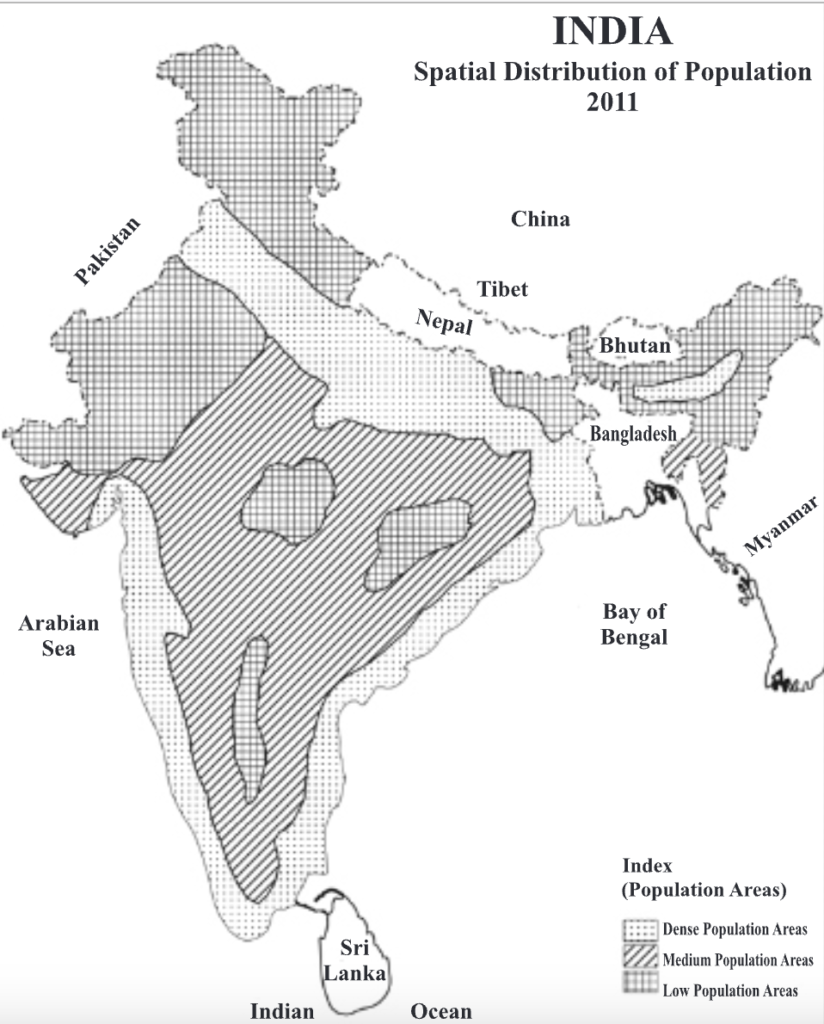

Factors Influencing Spatial Distribution of Population in India
- Climate: Extreme cold (Himalayas), heat (Thar Desert), and humidity (Eastern Himalayas) lead to sparse population, while moderate climates (Ganga plains) attract dense population.
- Relief and Topography: Flat and fertile plains like the Indo-Gangetic plain support dense population; hilly and rugged terrains discourage settlement.
- Water Availability: Areas near rivers (Ganga, Brahmaputra) and with irrigation (Punjab, Haryana) are densely populated; arid areas like Rajasthan depend on canal irrigation.
- Soil Fertility: Fertile alluvial soils promote agriculture and dense settlement (e.g., UP, Bihar), while infertile soils in plateaus and deserts limit population.
- Mineral and Industrial Resources: Mineral-rich regions like the Chotanagpur Plateau and Damodar Valley attract population due to mining and industry.
- Transportation and Connectivity: Well-connected regions like Delhi, Mumbai, and Kolkata have high populations due to better mobility and infrastructure.
- Socio-Cultural and Historical Factors: Cultural, religious, and trade centers like Varanasi, Jaipur, and Mysuru are densely populated.
- Political and Security Conditions: Political instability and border tensions in regions like Jammu & Kashmir and Northeast India lead to lower population density.
India’s physiographic divisions include the Himalayan mountains, Indo-Gangetic Plains, Deccan Plateau, Coastal Regions, and the Deserts. These diverse landforms influence population distribution and land use in various ways:
- The Himalayas and Northern Mountains
- Population: The Himalayan regions and North-Eastern Hill states are sparsely populated due to rugged terrain and difficult accessibility. The population here is lower compared to the plains.
- Land Use: Limited agricultural activity due to the steep slopes and lack of flat land. These areas are primarily used for forests and tribal settlements.
- The Indo-Gangetic Plains
- Population: This is the most densely populated area in India. The fertile soil of the Indo-Gangetic Plains, especially in Uttar Pradesh, Bihar, and Haryana, supports agriculture and leads to high population density.
- Land Use: The land is predominantly used for agriculture (rice, wheat, and sugarcane), with extensive irrigation systems in place. The alluvial soil and water availability from rivers like the Ganga, Yamuna, and Saraswati make it suitable for high-yield farming.(40% of total output)
- The Deccan Plateau
- Population: The Deccan Plateau in Maharashtra, Karnataka, and Telangana has a medium population density. Areas here are sparsely populated in the hilly terrain but more populated in plains like the Kaveri Delta.
- Land Use: Agricultural land in the plateau is used for cotton, groundnut, and pulses. The region also has significant mining and industrial activity due to the presence of rich mineral deposits.
- Coastal Regions
- Population: The coastal regions of Tamil Nadu, Kerala, Gujarat, and West Bengal have a high population density due to the fertile soil, favorable climate, and proximity to trade routes.
- Land Use: These regions are extensively used for agriculture (especially rice and coconut) and fisheries. Coastal cities also have ports that support trade and commerce, contributing to urbanization.
- The Thar Desert
- Population: The Thar Desert in Rajasthan has a low population density due to harsh climatic conditions like low rainfall, extreme temperatures, and limited water resources.
- Land Use: The land is mainly used for grazing and forestry, and agriculture is limited to drought-resistant crops. Irrigation projects like the Indira Gandhi Canal help increase land under cultivation in certain areas.
India’s landforms influence population and land use. Fertile plains, river valleys, and coasts support dense populations and farming, while mountains, plateaus, and deserts have lower populations and limited agriculture, causing regional disparities.