
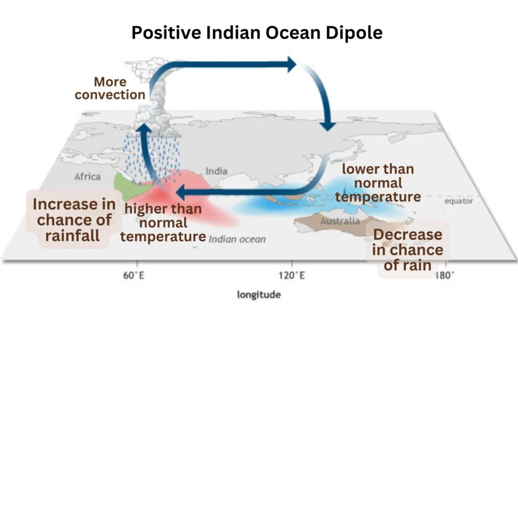
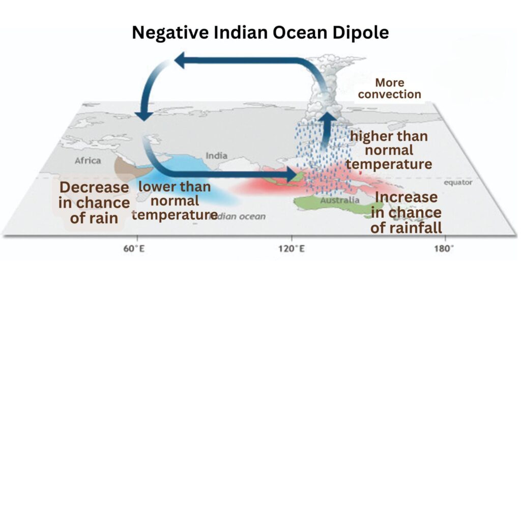
The Indian Ocean Dipole (IOD) influences the monsoon rainfall patterns.It can counter or amplify the effects of El Niño on the Indian monsoon.
- Positive IOD (warmer western Indian Ocean) – brings more rainfall and strengthens the monsoon and fosters cyclones in the Arabian Sea.
- Negative IOD (warmer eastern Indian Ocean) – reduces rainfall, often causing drought conditions and promotes cyclones in the Bay of Bengal.
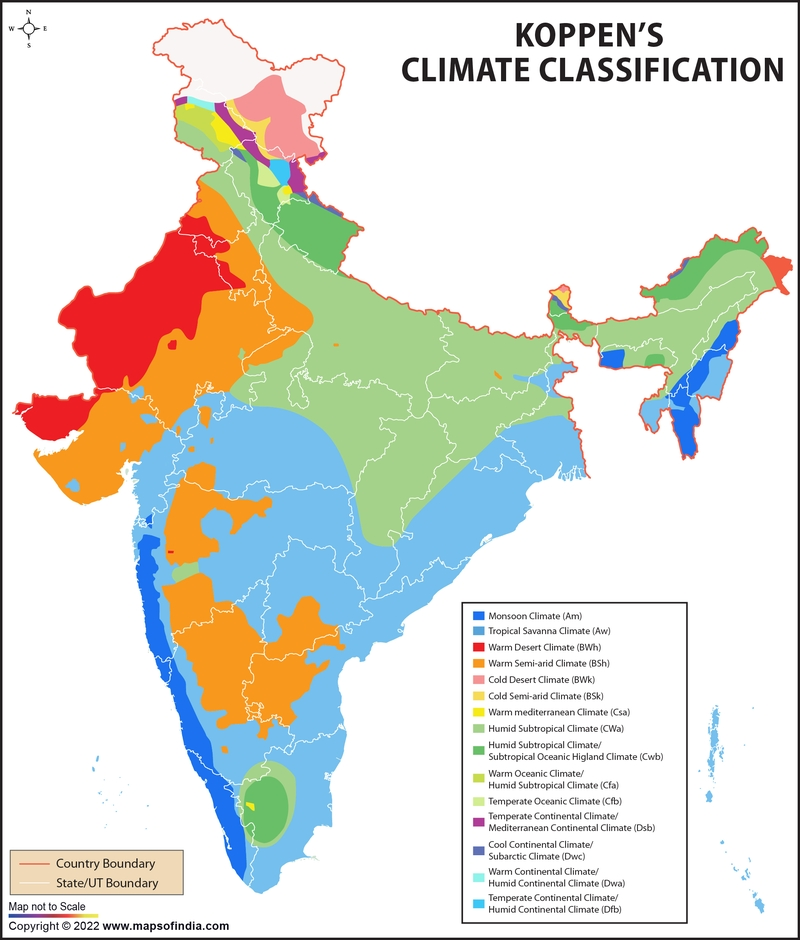
| Climate type | Region | Annual rainfall |
| Cwg(Monsoon type with dry winters) | Most parts of the Ganga Plain, eastern Rajasthan, Assam and in Malwa Plateau | 100 – 200 cm |
| Dfc(Cold, Humid winters type with shorter summer) | Sikkim, Arunachal Pradesh and parts of Assam | ~200 cm |
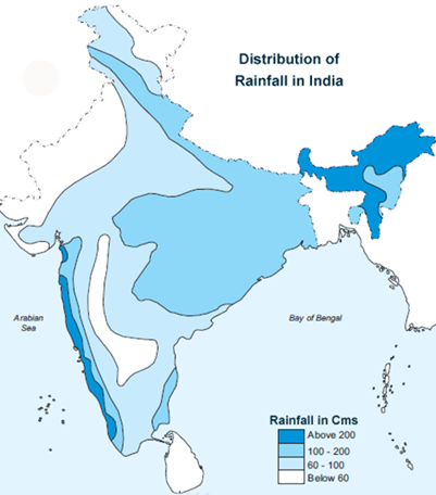
Distribution of Rainfall: The average annual rainfall in India is about 125 cm, but it has great spatial variations
- Areas of High Rainfall (more than 200 cm): Slopes of the Western Ghats and the Western Coastal Plains; Meghalaya Hills (Garo, Khasi and Jaintia), the southern slopes of the Eastern Himalayas, Assam, Arunachal Pradesh and West Bengal.
- Areas of Medium Rainfall ( 100-200 cm): in the southern parts of Gujarat, east Tamil Nadu, northeastern Peninsula covering Odisha, Jharkhand, Bihar, eastern Madhya Pradesh, northern Ganga plain along the sub-Himalayas and the Cachar Valley and Manipur.
- Areas of Low Rainfall (50-100 cm): Western Uttar Pradesh, Delhi, Haryana, Punjab, Jammu and Kashmir, eastern Rajasthan, Gujarat and Deccan Plateau.
- Areas of Inadequate Rainfall (50 cm and less): Parts of the Peninsula, especially in Andhra Pradesh, Karnataka and Maharashtra, Ladakh and most of western Rajasthan.
Factors Influencing Rainfall Distribution:
- Monsoon Winds: The distribution of rainfall is largely influenced by the southwest and northeast monsoons, with the Arabian Sea and Bay of Bengal branches impacting different regions.
- Distance from the Sea: Areas along the coast get more rainfall.
- Wind Direction: Due to the Arabian Sea Branch blowing corresponding to the Aravalli Hills, Rajasthan gets inadequate rainfall.
- Cyclonic Activity: Retreating monsoon brings widespread rainfall due to cyclonic depressions originating over the Andaman Sea, especially affecting the Coromandel coast.
- Topography: Regions like the Western Ghats, Himalayas, and coastal areas receive higher rainfall due to orographic lifting and convergence of winds.
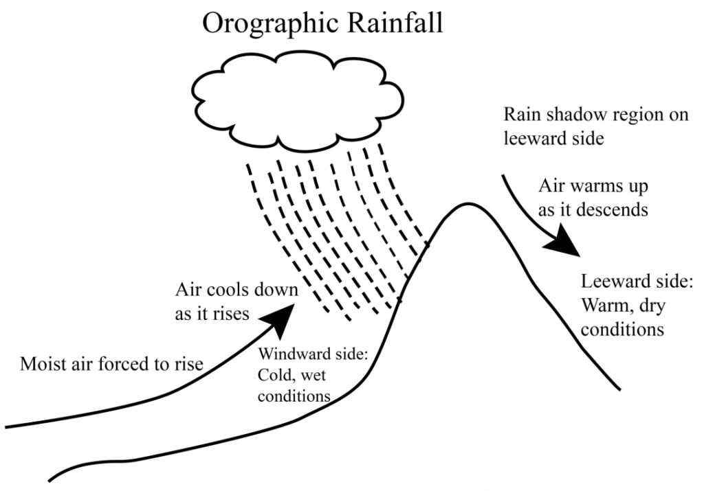
- Rain Shadow Effect: Areas lying in the rain shadow of mountain ranges, such as the area lying east of western ghat experience lower rainfall due to the blocking of moisture-laden winds.
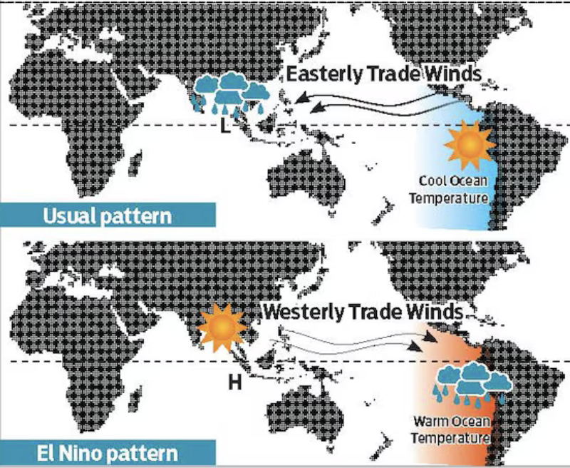
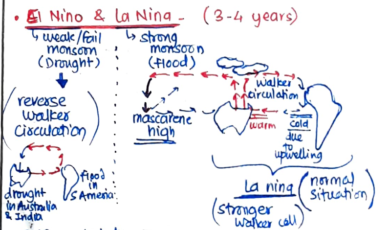
El Nino is a climatic phenomenon/complex weather system that causes a warm water current near the Peruvian coast, occurring every three to seven years. Since this stream appears in December at the time of Christmas, it is also known as ‘Child Christ’.
El Nino has an adverse effect on the Indian monsoon. Due to El Nino, the air pressure near the Peruvian coast becomes lower than normal, the force pushing the south-east trade winds from here gets weakened. Instead, the attracting or pulling force of the trade winds becomes effective here. Due to this, the flow of these trade winds towards Asia also becomes weak.
As a result, the Indian monsoon becomes weak and rainfall is significantly reduced, leading to below-average monsoon rainfall in India, often causing droughts, reduced agricultural yields, and water shortages.
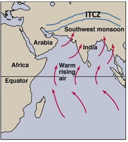
India gets southwest monsoon winds in the summers and northeast monsoons during the winters. It is a complex meteorological phenomenon, is influenced by a variety of factors that interact in intricate ways to determine its intensity, duration, and spatial distribution of rainfall.:
- Differential Heating of Land and Sea: During summer, the Indian subcontinent heats up faster than the surrounding oceans, creating a low-pressure area over the landmass. This draws in moist air from the Indian Ocean, leading to the onset of the southwest monsoon.
- Inter-tropical Convergence Zone (ITCZ): The ITCZ, which shifts northwards during the summer months, acts as a focal point for the convergence of moisture-laden winds from the southern hemisphere, aiding the onset and progression of the monsoon.
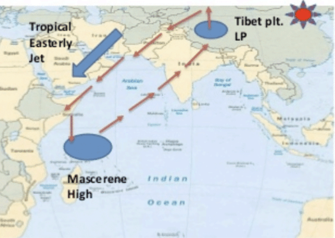
- Tibet Plateau and Tropical Easterly Jet Stream (Koteswaram theory):
- Summer Heating: During summer (June), intense heating of the Tibetan plateau causes air to rise, creating low pressure. Air rising from the plateau descends over the Southern Indian Ocean, east of Madagascar, forming the Mascarene High.
- Formation of TJES: Air moving from Tibet under coriolis force forms the Tropical Easterly Jet Stream (TEJS).
- Impact on Monsoon Winds: TEJS increases pressure differences between the Indian Ocean and Indian subcontinent, enhancing monsoon wind intensity.
- The Somali Jet Stream is a lower atmospheric jet stream originating from the eastern coast of Africa and blowing towards India during the monsoon season. It enhances the intensity of the Indian monsoon by transporting moisture from the Indian Ocean.
- Role of SubTropical Westerly Jet stream(Yin’s Theory):
- Onset of Monsoon: Northward movement of the southern branch of STWJ and the onset of monsoon in India are connected to each other. Re-establishment of south branch due to meandering will lead to break in monsoon.
- Western Disturbances : southern branch of jet stream exercises a significant influence on the winter weather conditions in India. It also brings cyclonic disturbances from the Mediterranean, causing rainfall in Northwestern India known as “Mawath” beneficial for rabi crops.
- El Niño-Southern Oscillation (ENSO): ENSO events in the Pacific Ocean, particularly El Niño and La Niña influence the Indian monsoon. El Niño tends to weaken the monsoon, while La Niña enhances it by altering sea surface temperatures and atmospheric circulation.
- Indian Ocean Dipole (IOD): A positive IOD, characterized by warmer waters in the western Indian Ocean, enhances monsoon rainfall over the Indian subcontinent, while a negative IOD has the opposite effect.
- Local Factors (Topography and Land-Sea Distribution):
- The topography of the Indian subcontinent, such as the Western Ghats, Eastern Ghats, and Himalayan ranges, significantly influences the distribution of rainfall through orographic effects. Coastal areas and regions close to mountain ranges receive higher rainfall due to these geographical features.
India’s rainfall is shaped by orographic and convectional patterns.
Orographic impact – when moist air masses rise due to mountain barriers, causing condensation and rainfall. Mountains significantly influence rainfall distribution in India.
- Himalayas: These mountains block cold Siberian winds, creating a tropical monsoon climate in India. They also divide the Bay of Bengal monsoon, causing heavy rainfall in Northeast India, especially in Mawsynram and Cherrapunji. The northern plains also get rain due to low-pressure areas.
- Aravallis: The Aravalli Range does not block the south-west monsoon, so western Rajasthan receives less rainfall due to the winds passing parallel to the mountains.
- Western Ghats: These mountains receive heavy rainfall on the western slopes (up to 250 cm), while the eastern slopes and Deccan Plateau are in a rain shadow, receiving less than 38 cm of rainfall.
- Eastern Ghats: This region, lying in the rain shadow of the Bay of Bengal monsoon, gets lower rainfall, especially in parts of Andhra Pradesh and Odisha.
- Arakan Yoma: This mountain range deflects the south-west monsoon winds, which then contribute to the Bay of Bengal branch, bringing rainfall to India.
Convectional rainfall in India
Convectional rainfall happens when the Earth’s surface heats up, causing the air near it to rise. As the warm, moist air goes up, it cools and forms clouds. These clouds can bring heavy rain, often with thunder and lightning.
Pattern in India:
- Pre-Monsoon Showers: Before the monsoon, India experiences pre-monsoon showers due to intense heating of the land.
- Mango Showers in Kerala and Karnataka occur in May and June, helping mangoes ripen and signaling the start of the monsoon.
- Thunderstorms: Kal Baisakhi in West Bengal and Assam brings strong thunderstorms with hail and winds, usually in April-May.
- Peninsular India:
- Maharashtra, Karnataka, and Tamil Nadu get convectional rainfall in summer when the land heats up, causing thunderstorms and heavy rain.
- Gangetic Plains:
- Uttar Pradesh, Bihar, and West Bengal experience convectional rainfall in summer due to intense heating of the land, leading to thunderstorms and rain.
- Northeast India:
- Assam, Meghalaya, and Arunachal Pradesh receive convectional rainfall, often enhanced by moisture from the Bay of Bengal, causing strong showers during the summer.
Orographic and convectional rainfall are key to India’s diverse rainfall patterns. Mountains cause heavy rain on windward slopes, while convectional rainfall, due to intense heating, brings thunderstorms and pre-monsoon showers.