Introduction of Rajasthan Geography – Geography of Rajasthan is an important subject that helps in understanding the physical features, climate, soil, rivers, vegetation, and natural resources of the state. Rajasthan, the largest state of India by area, shows great geographical diversity ranging from the Thar Desert to the Aravalli mountain range. Studying its geography provides a clear view of how natural conditions influence the culture, economy, and lifestyle of the people.
Introduction of Rajasthan
- Rajasthan has special significance in Indian history due to its magnificent historical traditions.
- Rajasthan is the centre of the world’s ancient civilisations. Its proofs are available in the remains found at Tilwara in Luni basin (Barmer), Ahar (Udaipur), Gilund (Udaipur), Kalibanga (Hanumangarh) and Ganeshwar Tila (Sikar).
- The people of the state have shown bravery and wisdom even after adapting to adverse and difficult situations with special identities in ancient and medieval periods.
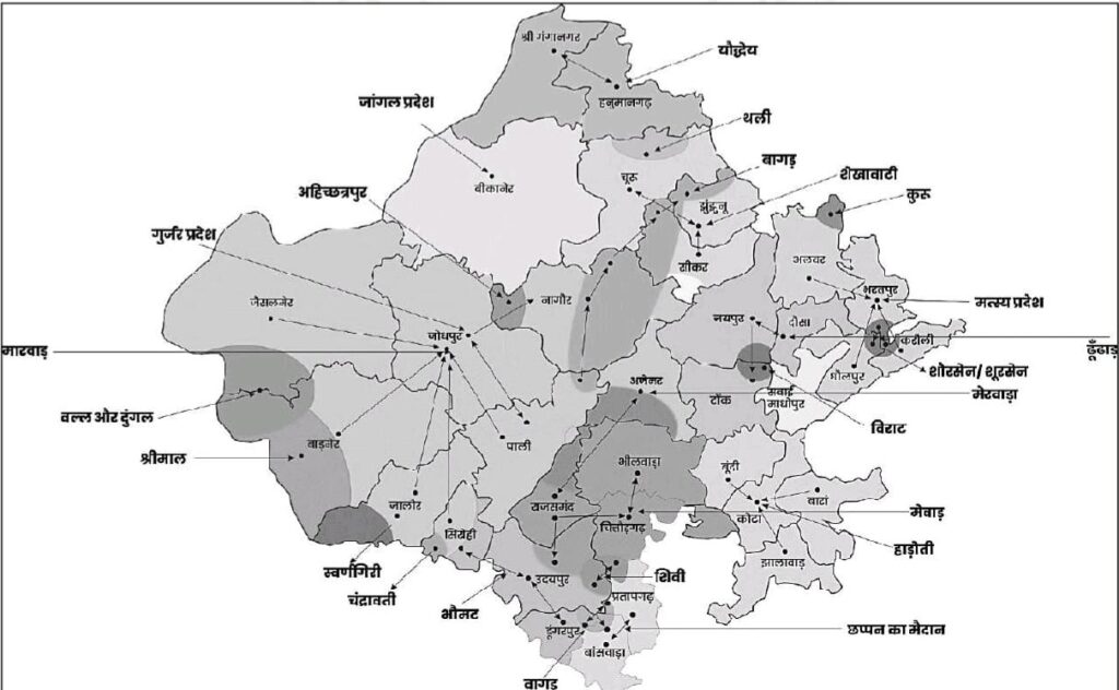
Special identities in Ancient and Medieval periods that were used for Districts
| Ancient and Medieval periods Districts | Current District |
| Yoddhaiya | Ganganagar – Hanumangarh |
| Jangal | Bikaner, Jodhpur |
| Ahichhatrapur | Nagaur |
| Gurjaratra | Jodhpur – Pali |
| Valla/Dungal/Maand | Jaisalmer |
| Swarngiri | Jalore |
| Chandrawati | Abu |
| Shiv/Medpat/Mewar | Udaipur, Chittorgarh, Rajsamand |
| Vagad | Dungarpur, Banswara, Pratapgarh |
| Kuru | Alwar |
| Shursen /Brijbhumi | Bharatpur, Karauli, Dholpur |
| Hay-Hay/Hadoti | Bundi – Kota, Baran, Jhalawar |
| Virat/Bairath | Alwar, Jaipur |
| Shakambari | Sambhar |
| Dhundhar | Jaipur – Tonk |
| Girwa | Nearby areas of Udaipur |
| Godwad | Barmer, Sirohi, Jalore |
| Shekhawati | Sikar, Churu, Jhunjhunu |
| Uparmal | Plateau region of Bhilwara and Chittorgarh |
| Kanthal | Pratapgarh and the nearby area |
| Merwara | Ajmer, Rajsamand, Beawar |
| Mewat | Alwar, Khairthal-Tijara, Deeg |
| Marwar | Jodhpur |
| Plateau Region of Bhorat | Regions of Udaipur, Gogunda, Rajsamand and Kumbhalgarh |
| Malwa | South-east plateau region |
| Salv region | Parts of Alwar |
| Maalani | Barmer – Jalore region |
Naming of Rajasthan
- In the Rigveda – Brahmavarta
- In the Ramayana – Marukantar
- The first written reference to the word ‘Rajasthan’ is found in the 625 CE Basanṭgarh inscription (Sirohi) in the form “Rajasthaniyaditya”
- The earliest evidence of the word ‘Rajasthan’ in any book appears in Muhnot Nainsi’s ‘Nainsi ri Khyat’ (1665 CE), which is considered the first historical text of Rajasthan.
- In 1731 CE, Veerbhan used the word ‘Rajasthan’ in his book ‘Rajarupak’, though not for the geographical region, but for the residence of the king.
- In 1791 CE, Jodhpur ruler Maharaja Bhim Singh used the word ‘Rajasthana’ in a letter addressed to Jaipur’s Sawai Pratap Singh.
- The term ‘Rajputana’ was first used in 1800 CE by George Thomas, and later mentioned by William Franklin in 1805 in his book ‘Military Memoirs of Mr George Thomas.
- The first person to use the word ‘Rajasthan’ officially for this geographical region was Colonel James Tod, in his work ‘The Annals and Antiquities of Rajasthan’ published in 1829.
- The word ‘Rajasthan’ received constitutional recognition on 26 January 1950, and its present territorial form was finalised on 1 November 1956.
- Rajasthan was known as Rajputana in the British period due to the dominance of princely states and thikana of Rajput kings.
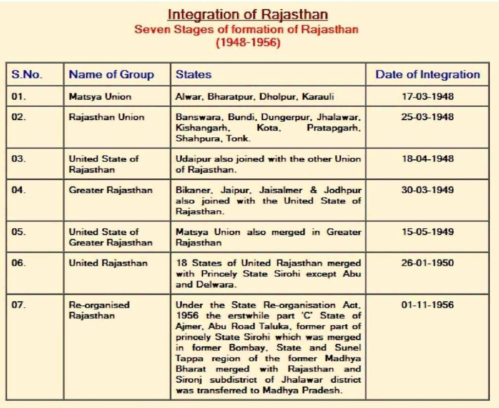
- The main princely states were Amer, Marwar, Mewar, Kota, Bundi, Bharatpur, etc. Present Rajasthan was formed through the integration of 19 princely states and 3 chiefships of Rajputana, along with the centrally administered territory of Ajmer–Merwara, after Independence.
|
Formation date |
Newly constructed district |
|
|
|
|
Facts related to district formation |
|
|
15 April, 1982 |
|
|
10 April, 1991 |
|
|
12 July 1994 |
|
|
19 July 1997 |
|
|
26 January, 2008 |
|
Geological History of Rajasthan
- According to Alfred Wegener, the division of Pangaea took place in the Carboniferous Period. There was a huge ocean around it, which Wegener called Penthalassa.
- The northern part of Pangaea was called Laurasia, and the southern part was called Gondwanaland.
- The Tethys Sea, a geosyncline, existed between these two parts.
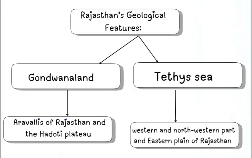
- In this way, most of the western and northwestern part and the Eastern plains of Rajasthan are the residue of the Tethys sea, which, due to the course of time, was filled with the alluvium deposited by the rivers descending from the Himalayas.
- Salt lakes of Rajasthan, like Sambhar, Didwana, Pachpadra, Lunkaransar, etc, are the remains of the Tethys Sea.
- The Aravallis of Rajasthan and the Hadoti plateau are parts of Gondwanalan
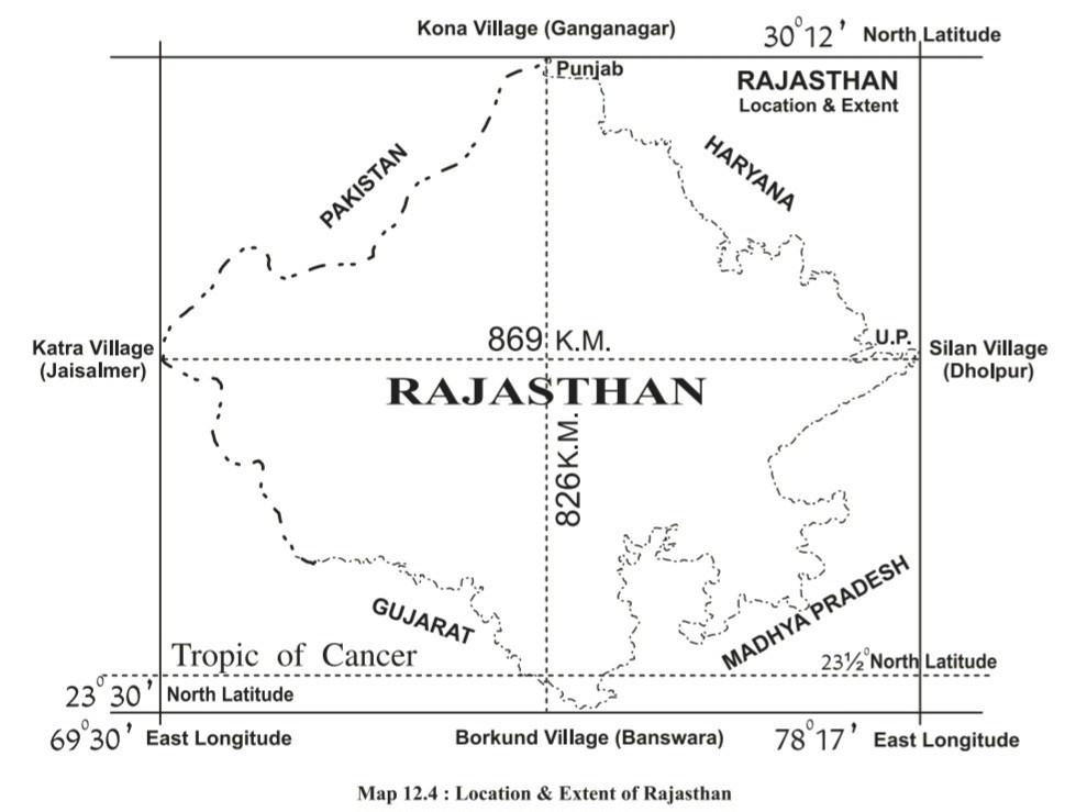
Extension of Rajasthan
| Extension of Rajasthan | |
| South to North(Latitudinal Extension) Range: 23°03’ N (Borkund, Banswara) to 30°12 ’N (Kona Village, Sri Ganganagar). Span: 7°9’.Distance: 826 km. | West to East (Longitudinal Extension) Range : 69°30’ E (Katra Village, Jaisalmer) to 78°17’ E (Silan Village, Dholpur). Span: 8°47’.Distance: 869 km. |
| The Tropic of Cancer (23°30’ N Latitude) passes through the Southern tip of the state near Banswara, including some parts of Dungarpur. | |
| Latitudinal and Longitudinal Gaps of Rajasthan are 7°09’ and 8°47’ respectively. | |
Location of Rajasthan
Global Location:
- Rajasthan is situated in the Northern Hemisphere by latitude and in the Eastern Hemisphere by longitude.
India’s Context:
- Rajasthan lies in the north-western part of India.
- The state is equal to Germany in area, slightly larger than Japan, one and a half times larger than Great Britain, five times larger than Sri-Lanka and more than seventeen times larger than Israel.
- The maximum width from East to West is 869 kms and from North to South the maximum length is 826 kms.
- The difference in the distance between the length and the breadth of Rajasthan is 43 kms.
- According to satellite surveys, Gagrana (Nagaur) is a geographically mid-sized village in Rajasthan.
- The difference between Dholpur (East) and Jaisalmer (West) is 35 minutes and 8 seconds.
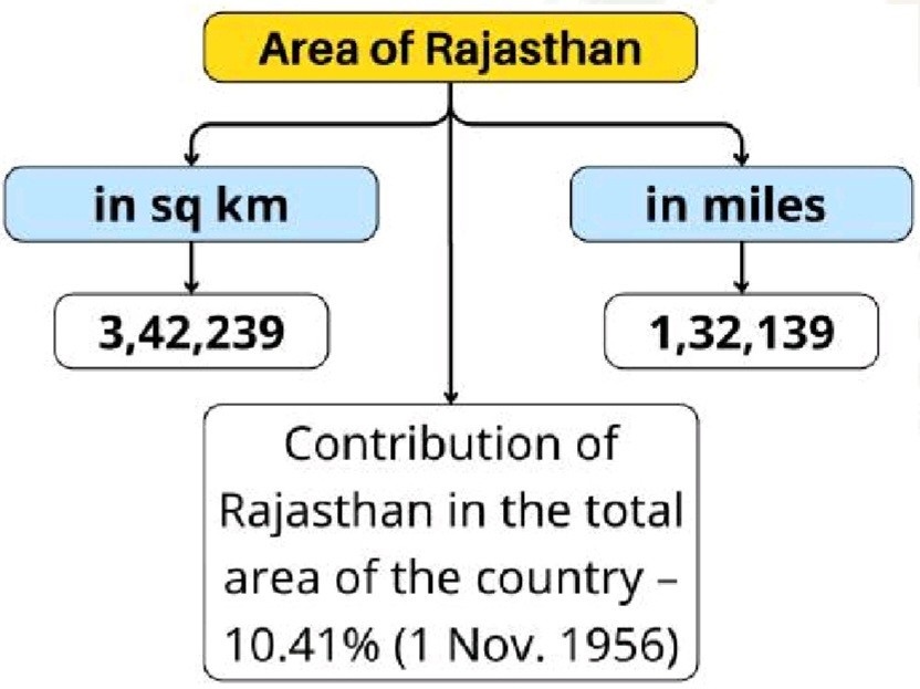
Area of Rajasthan
Shape of Rajasthan
| Shape of Rajasthan | |
| According to T.H. Handley, the shape of Rajasthan is rhombus-like (kite-shaped) |
Boundary of Rajasthan
- Rajasthan has a total land boundary of 5920 km, of which 1070 km is the international border, and 4850 km is the interstate boundary.
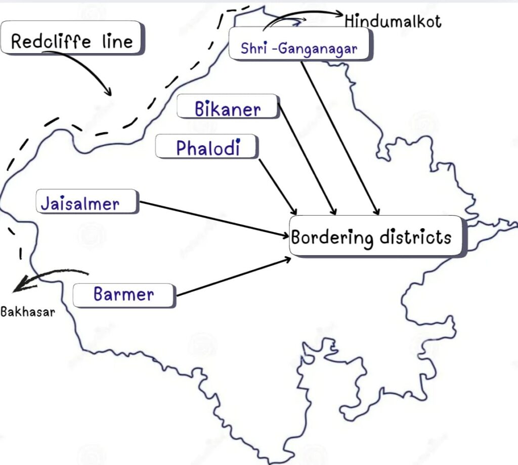
- The international boundary between Rajasthan and Pakistan has a length of 1070 kilometers which is known as the Radcliffe Line. Hindumalkot (Sri Ganganagar) is the starting point, and Shahgarh or Bakhasar (Barmer) is the end point of this boundary.
- The Redcliffe line is of total length 3310 km and touches three states of India (Rajasthan, Gujarat and Punjab) and two union territories (Jammu Kashmir and Ladakh).
- Five districts of Rajasthan lie on the Redcliffe line. They are Ganganagar, Bikaner (168 km), Phalodi, Jaisalmer (464 km) and Barmer (from North to South).
- Bahawalnagar, Bahawalpur, Rahimyar Khanpur districts of Punjab province, and Ghotki, Sukkur, Khairpur, Sanghar, Umarkot, and Tharparkar districts of Sindh province of Pakistan lie on the Indo-Pak border.
- Jaisalmer shares the largest border with the international boundary.
- Phalodi shares the smallest border with the international boundary.
- Sri-Ganganagar is the closest headquarters to the international boundary.
- Bikaner is the farthest headquarters from the international boundary.
- Sri Gangangar and Barmer share both interstate and international boundaries.
- Interstate Boundary – 4850 km of the interstate boundary of Rajasthan.
| States | Shared boundary | Bordering districts of Rajasthan |
| Punjab | 89 km | Sri-Ganganagar, Hanumangarh |
| Haryana | 1262 km | Hanumangarh, Churu, Jhunjhunu, Sikar, Kotputli -Behror, Khairthal–Tijara, Alwar, Deeg |
| Uttar Pradesh | 877 km | Deeg, Bharatpur, Dholpur |
| Madhya Pradesh | 1600 km | Dholpur, Karauli, Sawai-Madhopur, Kota, Baran, Jhalawar, Chittorgarh, Bhilwara, Pratapgarh, Banswara |
| Gujarat | 1022 km | Banswara, Dungarpur, Udaipur, Sirohi, Jalore, Barmer |
- There are 4 such districts of Rajasthan which form the border with two states.
- Hanumangarh – Punjab and Haryana
- Deeg – Haryana and Uttar Pradesh
- Dholpur – Uttar Pradesh and Madhya Pradesh
- Banswara – Madhya Pradesh and Gujarat
- Two districts of Rajasthan share a border with the Punjab state – Sri-Ganganagar and Hanumangarh
- The district with the largest interstate border in Rajasthan – Jhalawar (520 km)
- The district with the shortest interstate border in Rajasthan – Barmer (14 km)
- Total border districts in Rajasthan (any type of border ) – 28 districts.
- Total districts sharing an Interstate border in Rajasthan – 25 districts.
- Total districts : Sharing only an Interstate border in Rajasthan – 23 districts .
- Inland district of Rajasthan – 13 districts
- Interior districts are:-
- Jaipur, Dausa, Tonk, Bundi, Ajmer, Beawar, Didwana-Kuchaman, Nagaur, Jodhpur, Balotra, Pali, Rajsamand and Salumber.
- The Chittorgarh district of Rajasthan forms a border with the state twice, but it is fragmented.
- The Kota district of Rajasthan forms a border with the state twice, but it is not fragmented.
- Kota and Chittorgarh are those districts of Rajasthan which form a border with the state of Madhya Pradesh twice.
- Bhilwara divides Chittorgarh into two parts.
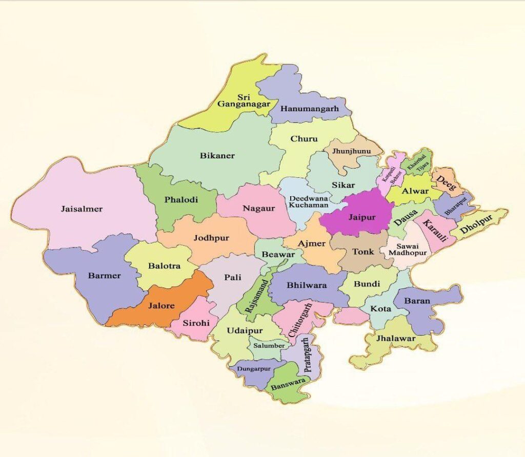
- Jaisalmer, Bikaner, Barmer, and Jodhpur are the largest districts in terms of area, and Dholpur, Dausa, Dungarpur, and Pratapgarh are the smallest districts (as per old data).
Districts and Divisions as per the revised map
| Districts and Divisions as per the revised map | |
| Divisions | Districts included |
| Jaipur | Jaipur, Kotputli-Behror, Dausa, Alwar, Khairthal-Tijara, Sikar, Jhunjhunu |
| Bharatpur | Bharatpur, Deeg, Dholpur, Karauli, Sawai-Madhopur |
| Ajmer | Ajmer, Tonk, Beawar, Nagaur, Deedwana-Kuchaman, Bhilwara |
| Kota (Smallest + minimum districts) | Kota, Baran, Bundi, Jhalawar |
| Udaipur | Udaipur, Chittorgarh, Salumber, Rajsamand, Banswara, Dungarpur, Pratapgarh. |
| Jodhpur (Largest) (Maximum Districts) | Jodhpur, Phalodi, Jaisalmer, Barmer, Balotra, Pali, Jalore, Sirohi |
| Bikaner | Bikaner, Sri-Ganganagar, Hanumangarh, Churu |
Districts as per the revised map
| Sri Ganganagar | Hanumangarh | Bikaner | Churu |
| Jhunjhunu | Sikar | Deedwana-Kuchaman | Nagaur |
| Jodhpur | Phalodi | Jaisalmer | Barmer |
| Balotra | Jalore | Pali | Sirohi |
| Udaipur | Rajsamand | Chittorgarh | Salumber |
| Banswara | Dungarpur | Pratapgarh | Bhilwara |
| Jaipur | Deeg | Ajmer | Beawar |
| Dausa | Alwar | Bharatpur | Khairthal-Tijara |
| Kotputli-Behror | Sawai-Madhopur | Tonk | Karauli |
| Dholpur | Baran | Bundi | Kota |
| Jhalawar |