
Transport Network In world geography, a transport network refers to the interconnected system of roads, railways, waterways, and air routes that facilitate the movement of people and goods. It plays a crucial role in economic development, regional connectivity, and globalization by linking different parts of the world.
Modes and Global Distribution of Transport Systems
- The transfer or movement of goods and people from one place to another by means of any physical medium is called transport.
- The regional pattern of the transport system of any state is called the transport network.
- The modern means of transport may be put under three broad categories-
- Land (Roads and rail routes)
- Water
- Air
- Other pipelines (water, oil and gas)
- Land Transport
- Land transport can be divided into two major parts-
- Road transport
- Rail transport
- Roads : Roads are of two types :
- Unmetalled Roads
- Metalled roads
Road Transport
Length of Roads
| Country | Road Network Size 2025 (km) |
| United States | 66,45,582 |
| India | 63,60,004 |
| China | 54,36,845 |
| Russia | 15,79,923 |
| Brazil | 15,63,600 |
| Australia | 13,22,245 |
| Japan | 12,31,084 |
| France | 11,18,600 |
| Canada | 10,42,718 |
| Germany | 8,29,530 |
Major Road Routes of the World
|
Highway |
Connected Regions / Countries |
Important Details |
|
Pan-American Highway |
North America, Central America, South America |
|
|
Trans-Canadian Highway |
Canada (East–West) |
|
|
Alaska National Highway |
Canada–USA |
|
|
Stuart Highway |
Australia (North–South) |
|
Regional Distribution of Road Transport
United States of America (USA)
- Highway density in North America is very high, about 0.65 km per sq km.
- Almost every place is within 20 km of a highway.
- Total road length is about 66 lakh km, the highest in the world.
- The majority of roads are concentrated in the eastern part of the USA.
- The USA has about one-third of the world’s total road length.
- Nearly half of the world’s motor vehicles are found in the USA.
- The dense road network is due to high industrialization and urbanization in the eastern region.
Africa
- Due to diverse landforms, roads are the most important means of transport.
- Railways and waterways are limited in many regions.
- Roads provide connectivity across deserts, plateaus, and forested areas.
Europe
- Europe has a well-developed and dense network of highways.
- A large number of vehicles operate on European roads.
- Road transport faces strong competition from railways and waterways.
Russia
- A dense highway network is found in the industrial region west of the Ural Mountains.
- Moscow acts as the central axis of the road network.
- The Moscow–Vladivostok National Highway serves eastern Russia.
- Due to the large geographical extent, road density is lower than railways.
- Rail transport is more dominant than road transport in Russia.
China
- Roads are the major means of transport in China.
- The road network is mainly spread over the eastern plains.
- Highways criss-cross and connect major cities:
- Tsungtso (near Vietnam border)
- Shanghai (central China)
- Guangzhou (south China)
- Beijing (north China)
- A recent Sichuan-Tibet Highway connects Chengdu (Sichuan province) to Lhasa (Tibet Autonomous Region).
India
- India has a large network of national highways.
- As of March 2025, India’s road network stands at more than 63 lakh kilometres, the second largest in the world.
- Within this, the National Highway network has grown to 1,46,204 kilometres
- Roads in India are classified into:
- National Highways
- State Highways
- District Roads
- NH 44 is the longest, running from Srinagar (Jammu & Kashmir) to Kanyakumari (Tamil Nadu)
- Under the Corridor Plan:
- East–West Corridor: Silchar (Assam) to Porbandar (Gujarat)
- North–South Corridor: Kashmir to Kanyakumari
- Six-lane and eight-lane highways and green corridor highways are under construction.
- Construction and maintenance of national highways are carried out by the National Highway Authority of India (NHAI).
Border Roads
- The roads built along the international borders are called Border roads.
Rail Transport
- In England, James Watt invented the engine in 1769 and George Stephens invented the steam engine in 1814 for the first time.
- On September 27, 1825 the first train of the world started in England between Arcton of Northern England and Darlington.
- The breadth (gauge) of rail lines is different in each country.
- Generally, they are classified into broad gauge (more than 1.5 metres), metre gauge (1 metre) and narrow gauge.
- Rail transport in India started in 1853 between Mumbai and Thane (34 kms.).
- The Indian Rail is operated in four lines
- Broad gauge (width 1.676 metre)
- Metre gauge (width 1 metre)
- Narrow gauge (0.762 metre) and
- Lift gauge (0.610 metre).
- The use of Standard gauge also known as Stephenson Gauge(1.44 meter), in the world, is done in Britain.
Railway density (Kilometres of lines operated per 1000 sq. kms.)
| Position | Country | Density |
| 1. | Switzerland | 128.8 |
| 2. | Czechia | 120.6 |
| 3. | Belgium | 118.9 |
Total Railroad Length (km)
| Country | Total Railroad Length (km) |
| United States | 220,044 |
| China | 159,000 |
| Russia | 105,000 |
| India | 65,554 |
| Canada | 49,422 |
| Germany | 39,379 |
| Australia | 36,064 |
| Brazil | 29,850 |
| France | 27,860 |
| Japan | 27,311 |
Regional Distribution of Rail Transport
|
Continent |
Key Points on Rail Network |
|
Europe |
|
|
Russia |
|
|
Asia |
|
|
North America |
|
|
South America |
|
|
Africa |
|
|
Australia |
|
Major Rail routes of the world
|
Railway Route |
Route & Major Centres |
Special Features |
|
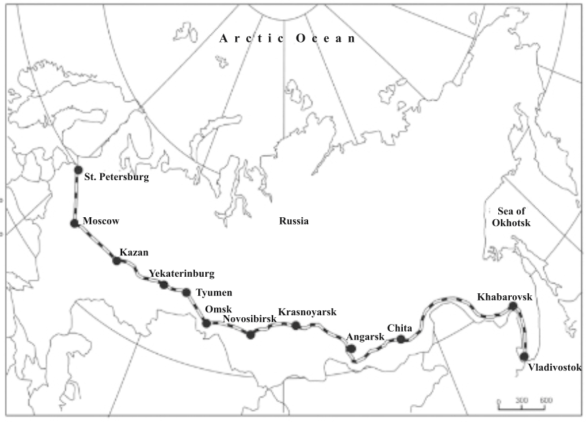
Trans-Siberian Railway (Asia–Europe, Russia – 9,560 km) |
Leningrad (St. Petersburg) → Moscow → Tula → Kuiveshev (Volga River) → Ufa (Ural region) → Viliyaibinstu → Omsk (Steppes) → Cheeta → Vladivostok |
|
|
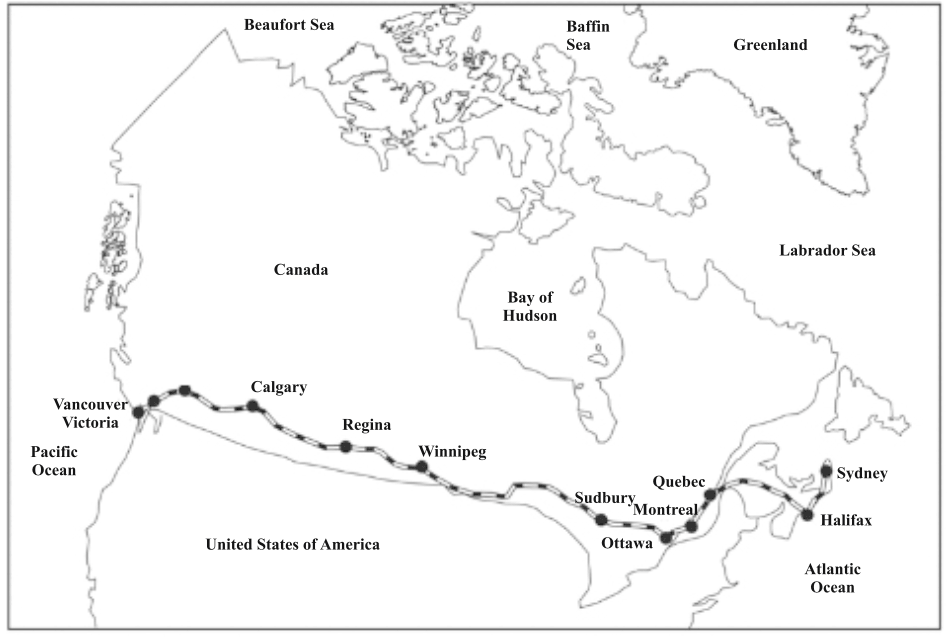
Canadian Pacific Railway (North America, Canada – 7,050 km) |
Atlantic Coast → Quebec → Montreal → Pacific Coast |
|
|
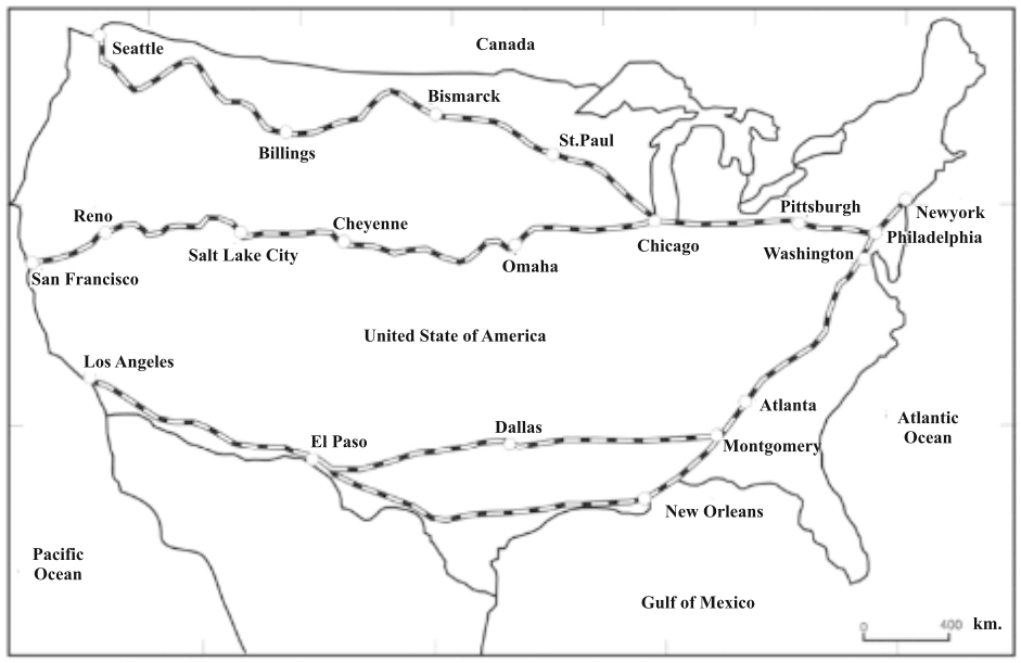
Northern Inter-continental Railway (North America, USA – 6,100 km) |
New York → Pittsburgh → Chicago → Chicago-Gary industrial area (Lake Michigan) → Bismarck (Prairie region, Saint Paul) → Rocky Mountain passes & tunnels → Seattle |
|
|
Central Inter-continental Railway (North America, USA) |
New York → Chicago → Omaha (River Missouri) → Platte River Valley → Cheni City → Salt Lake City (Inns Pass, Rocky Mts.) → Sacramento → San Francisco |
|
|
Southern Inter-continental Railway (North America, USA) |
New York → New Orleans → Los Angeles |
|
|
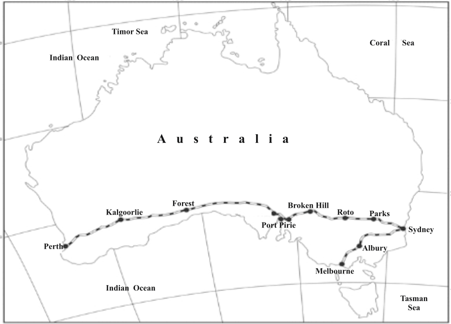
Australian Inter-continental Railway (Australia) |
Sydney → Great Dividing Range → Broken Hill (River Darling) → Peter Buro → Port Pirie → Port Augusta → Kalgoorlie → Coolgardie → Perth |
|
|
Orient Express Railway (Europe) |
Paris → Strasbourg → Munich → Vienna → Budapest → Belgrade → Istanbul |
|
|
Asiatic Railway – Proposed (Asia) |
Istanbul → Iran → Pakistan → India → Bangladesh → Myanmar → Bangkok |
|
|
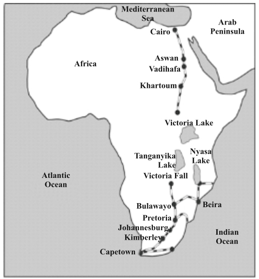
Cape–Cairo Railway – Proposed (Africa – 14,000 km) |
Cairo → Sudan → Central Africa (missing link) → Zimbabwe → Pretoria → Kimberley (Gold mine) → Cape Town |
|
Trans-Siberian Railway
Trans-Canadian Rail route
Intercontinental Rail route of U.S.A.
Australian Transcontinental Rail route
Cape Cairo Rail route
Water Transport
- Water transport is the cheapest and most easily available means of transport among all modes.
- Water routes pass through rivers, lakes, canals and oceans.
- Mainly used for transporting cheap and heavy goods such as coal, iron ore, iron and steel, cement, grains, etc.
- Water transport is divided into two categories:
- Inland Waterways
- Sea or Ocean Waterways
- Inland waterways pass through rivers and lakes located within continental or land areas.
- Only seasonal transport is possible in rivers and lakes that dry up in summer or freeze in winter.
- Inland water transport is well developed in regions having large rivers with sufficient and regular water flow.
- The major inland waterways of the world are found in areas with big perennial rivers.
Major Inland Waterways of the World
|
Continent |
Details |
|
Europe |
|
|
North America |
|
|
Asia |
|
|
South America |
|
|
Africa |
|
|
Australia |
|
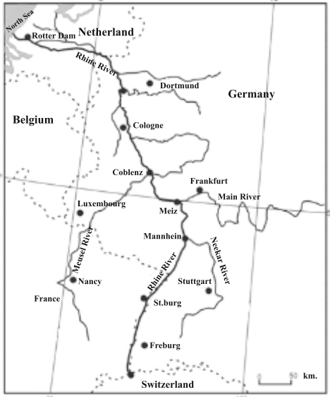
Rhine Waterways
Major Ocean Waterways of the World
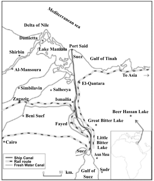
Suez Canal Route
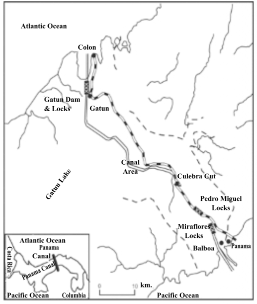
Panama Canal Route
|
Ocean Waterway |
Connected Regions / Route |
Key Features / Importance |
|
North Atlantic Route |
Western Europe ↔ North America (U.S.A. & Canada) |
|
|
Mediterranean Sea–Indian Ocean Waterway |
Western Europe ↔ Eastern Africa ↔ South Asia ↔ Australia ↔ New Zealand |
|
|
Cape of Good Hope Route |
Western Europe & Western Africa ↔ South America |
|
|
Southern Atlantic Waterway |
Eastern South America ↔ Africa ↔ Asia ↔ Australia |
|
|
Caribbean Sea Route |
Caribbean countries ↔ Gulf of Mexico ↔ U.S.A. |
|
|
Pacific Ocean Waterways |
Americas ↔ East & South-East Asia ↔ Australia & New Zealand |
|
|
Suez Canal Route |
Mediterranean Sea ↔ Red Sea ↔ Indian Ocean (North America ↔ Europe ↔ Asian countries ↔ Australia & New Zealand) |
|
|
Panama Canal Route |
Atlantic Ocean ↔ Pacific Ocean |
|
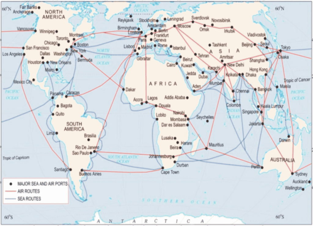
Air Transport
Major Sea & Air routes of the world
|
Type of Airways |
Features |
|
Inter-Continental Global Airways |
|
|
Continental Airways |
|
|
National Airways |
|
|
Regional Airways |
|
|
Local Airways |
|
|
Special / Official Airways |
|
Major Airports of the World
| Continent | Major Airports / Cities |
| North America | New York, New Orleans, Chicago, San Francisco, Los Angeles (U.S.A.); Montreal, Ottawa (Canada); Mexico City |
| South America | Rio-de-Janeiro, Buenos Aires, Santiago, etc. |
| Europe | London, Paris, Berlin, Rome, Moscow, etc. |
| Asia | Tokyo, Shanghai, Beijing, Bangkok, Singapore, Jakarta, Rangoon, Kolkata, Mumbai, Delhi, Chennai, Karachi, Colombo, etc. |
| Africa | Cape Town, Addis Ababa, Nairobi, Cairo, etc. |
| Australia | Sydney, Melbourne, Perth, Canberra, etc. |
Pipeline Transport
- Pipelines are the most modern means of transport.
- Through pipelines, crude oil reaches the refineries and purified petroleum products reach the consumer centres.
- Transport of natural gas is also done by pipelines.
- Greater density of pipelines in the world is found in Europe and Middle East countries.
- Pipelines ensure uninterrupted flow and transport of liquid and gaseous materials such as water, petroleum and natural gas.
- Supply of domestic gas and L.P.G. in many parts of the world is done by pipelines.
- In New Zealand, milk is sent from farms to factories by means of pipelines.
- A dense network of oil pipelines exists between producing areas and consumer centres in the U.S.A.
- Pipelines are used to connect oil wells with refineries, ports and domestic markets.
- Pipelines have been extended to Iran and some ports of China from Turkmenistan in Central Asia.
- The proposed Iran–India gas pipeline via Pakistan will be the longest international oil and natural gas pipeline in the world.
Major Pipelines of the World
|
Pipeline Name |
Details |
|
Big Inch Pipeline |
|
|
TAP Line (Trans-Arabian Peninsula) Pipeline |
|
|
TAP Pipeline (Trans Adriatic Pipeline) |
|
|
COMECON Pipeline |
|
|
O.I.L. Pipeline |
|
|
H.V.J. Pipeline |
|
|
TAPI Pipeline (Still in progress) |
|
