
In World Geography, plains are expansive, flat, or gently rolling landforms, typically found at low elevations, formed by sediment deposition from rivers, glaciers, or wind. These second-order relief features support agriculture, human settlements, and ecosystems, significantly shaping global landscapes and economies.
- Plains are the simplest and clearest among the second order relief features on the earth’s surface.
- Plains are spread over approximately 55 percent of the surface.
- The part of earth’s surface which is comparatively more flat, successive and gentler slope and have lower elevation is called plain.
- Plains have dissimilarities in reference height above sea level. Like Polder plain of Holland is lower than sea level whereas the plains of the lakes in Kashmir are situated at the height of 1700 m. On the other hand the northern plain of India extends from 8 metre high delta region to 200m high plain in Punjab
- Most of the plains of the world are formed by the soil brought by the rivers. Apart from this, some plains are also formed by volcanoes, glaciers and wind.
Origin and development of plains
The plains found on the earth’s surface are formed by the following forms–
- Most of the vast plains are formed by the upliftment of landmasses from the sea due to the tectonic force. For example – Great Plains Province of USA.
- Due to tectonic force, the land portion in front of the mountain often subsides and the deposits brought by rivers form vast plains. For example – Northern Plains of India.
- When the central mass is not affected by the folding process during mountain formation, the central mass remains flat. If this portion is lower than the edges, it is called a plain. For example – Plains of Hungary.
- The coastal portion of the sea shores gets submerged due to flooding. The deposits keep getting deposited on them by the sea water. Due to which coastal plains are formed. For example – South-Eastern Coast of India.
- When a part of the ocean recedes, the landmass there dries up and becomes a plain. For example – India’s Kutch Plain.
- Due to continuous erosion, plateaus get eroded and take the form of plains.
Classification of plains
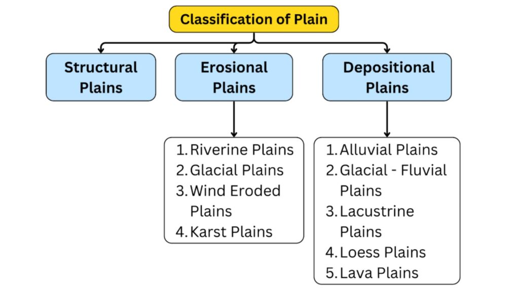
1. Constructive or diastrophic plain-
- Plains formed due to the rise of the submerged continental coast or its sinking under the land are called constructive plains.
- Under the process of plate deformation, the land parts are raised and subsided due to continental forces.
- When a land mass emerges from the sea as a result of land movement, a structural plain is formed. For example, the great plain of USA and the Russian platform of Russia. After emergence, the erosion and deposition of water and glaciers also contribute to the development of these plains.
- Coastal plains are formed as a result of the lithosphere rising above the sea level near the sea coast. For example, the Atlantic coastal plain of the United States of America.
- If the sea coast gets submerged as a result of land movement, then it turns into a plain as a result of deposition. For example – Karnataka and Eastern Coastal Plain of India.
2. Erosional plain
Through the process of erosion, over a long period of time, mountains and plateaus are disintegrated by factors like rivers, winds, glaciers and sea waves and take the form of plains. –
- Riverine plains
- The rivers transform the undulating surface with their erosional work into flat plains.
- When rivers cut through high land mass (plateau, mountain etc.) by the process of erosion and attain their base level. The plain thus formed is called ‘peneplain’ or ‘Riverine plain’.
- In these plains,hard rocks which are resistant to erosion are visible as small ridges and are called Monadnocks.
- The basins of Paris and London are examples of these types of plains.
- Glaciated plain-
- Higher mountain ranges and latitudes are mostly covered with snow. The surface beneath the snow undergoes attrition and abrasion, which turns the surfaces into flat plains.
- In the glacially eroded plains, the peaks are round and the valleys are wide. Due to this, pits are formed. When these plains get filled with water, these plains take the form of lakes.
- Glaciated plains are found in Canada, Sweden, Finland.
- Wind eroded plain-
- Rocks from arid regions are disintegrated by mechanical weathering. Due to which these rocks become loose. Wind blows away the loose and broken rock pieces with mechanical erosion. The rocks lying in the direction of the winds get eroded through the process of abrasion by the wind. This abrasion results in the formation of Pediplain.
- Calcareous plain or Karst plain-
- In the areas of limestone rocks, by the end of the erosional cycle of the underground water, the topographical features are transformed into a Karst plain.
- The Karst plains of Nainital and Almora in India ,Yugoslavia and France are its examples.
3. Depositional plain
Plains formed by deposition are large and small. Plains deposited by various factors of erosion can be divided into the following parts-
- River formed plains: When rivers bring deposits from the highest regions to lower regions, they form the most extensive plains.
- Alluvial plains – These plains are formed by the deposition of debris brought down by the rivers from higher elevations to the lower regions. These plains are called Piedmont plain or Deltaic plain on the basis of their locations. The Deltaic plains of Ganga Brahmaputra and Nile rivers are very fertile and thickly populated.
- Floodplains-During floods, the plain formed up to the distance where the river water spreads and deposits fine particles is called flood plain. Flood plains are formed by alluvium/ sand/ alkaline soil which is very fertile for agriculture. Alluvial plains are usually divided into the following parts-
- Khadar Plain – The area where flood water reaches every year and new alluvial soil keeps getting deposited is called Khadar Plain.
- Bangar Plains- The areas where flood water does not reach are called Bangar Plains. The flood plains formed by rivers like Nile, Ganga, Sutlej, Mississippi etc. form Khadar and Bangar plains.
- Delta Plains – When rivers fall into seas or lakes, they accumulate deposits near the mouth which is called ‘delta’. Deltas are usually triangular in shape. It appears in the form of the Greek letter ∆. Hence, this plain is called ‘delta’. The plains formed at the mouths of rivers like Indus, Mississippi, Ganga etc. are deltaic plains.
- Lake-formed plains – Lake-formed plains are formed in two forms. In the first form, when rivers keep depositing sediments in the lake, the depth of the lakes decreases and gradually the lake gets filled with deposits and a flat plain is formed. In the second form, due to the endogenous force of the earth, the bottom of the lake rises due to the plate-deformation movement, due to which its water flows out and a plain is formed. The extent of the lake-formed plain depends on the size of that particular lake. There are many such plains in Canada, Western Europe and the United States of America. Plain of Hungary
- Lava Plains – When the lava emitted by a volcanic eruption is deposited in the form of a thin sheet and forms a flat area, it is called a lava plain. Plains are also formed by the erosion of lava plateaus. Examples of lava plains are found in Iceland, Argentina, United States of America etc.
- Plains deposited by wind: When wind blows at high speed in dry areas, it blows away sand and deposits it at other places. In this way, two types of plains are formed.
- Desert Plains – In desert areas, the wind deposits sand or silt at other places and forms plains, this is also called desert plains. Example – Thar Desert of India, Sahara Desert of Africa.
- Loess Plains – The storms blowing in desert areas carry sand particles far away and deposit them elsewhere, thereby forming a plain called the Loess Plains. The Loess Plains formed in China’s Shensi province are world famous.
- Plains deposited by glaciers – Plains are formed by the deposition of debris by glaciers, which are called glacial plains. The surface of these plains is not flat and is marshy and uneven. The pebbles, stones and gravel brought by the glacier below the snow line deposit the clay [till] plain and the sediment plain is formed by the deposition of fine soil by the melted water of the glacier.
Importance of Plains
- More than 80 percent of the world’s population lives in the plains.
- The major civilizations of the world – Indus Valley Civilization, Babylonian Civilization of Tigris-Euphrates, Nile Valley Civilization etc. have developed in the plains, hence plains are called the ‘Cradle of Civilizations’.
- Plains are convenient and useful from the point of view of human settlement, agriculture, pastures, traffic and transportation.
- Being flat, plains are convenient for building railway lines, roads and airports.
- In the plains, means of irrigation, especially canals, can be easily built.
- Plains are the best places for all types of human activities. The densely populated areas of the world are settled in the plains only.
Plains of the world
ASIA
Turan lowlands
- Spread across Turkmenistan, Uzbekistan, and Kazakhstan (Central Asia).
- Formed by the Amu Darya and Syr Darya rivers.
- In Kazakhstan it is called the Turkai Plateau.
- Most of its area is marshy.
Plain of Manchuria
- Northeast China Plain.
- Formed by the Amur River and its tributaries.
- Temperate forest region
- Soil black and fertile [Chernozem soil]
- Heavy industry and food processing industry developed here.
Tarim Basin
- In the western part of China [bounded by the Tien Shan Mountains to the north, the Kunlun Mountains to the south, the Pamir Mountains to the west, the Gansu Corridor to the east]
- China’s major oil and natural gas producing region.
- The Tarim Basin was an important part of the ancient Silk Road.
Junggar Basin
- Also known as the Dzungarian Basin, is one of the largest sedimentary basins in northwestern China.
- Between the Altai Mountains in the north and the Tien Shan Mountains in the south
Hwang Ho River Plain
- It is made up of yellow soil deposits brought down from the Loess Plateau formed by the Huang Ho River, so it is also called the Yellow Plain.
Yangtze River Plain
- This area is called the Changjiang River Plain, which is the largest alluvial plain in China, created by the Yangtze River.
Sichuan Basin
- A region in China running from southeast to north with mountain ranges.
- A flat plain descended by red rocky hills.
Siberian Plain and other plains of Russia
- Located in Russia, which extends from the Ural Mountains to the Lena River.
- The annual temperature difference here is very high (-80).
- The population density in this plain is very low.
Plain of Eastern Siberia – from the Lena River to the Pacific Coast Range. Verkhoyansk, Yablonoye, and Stanovoy Mountains are located in this part.
Western Siberia – Extends between the Ural Mountains and the Yenisei River. It is one of the largest plains in the world. Ob and Irtysh rivers drain here.
Plain of European Russia – It is a part of the central plains of Europe. Extends from the Arctic Ocean in the north to the Black Sea and the Caspian Sea in the south. The Volga River is important here.
Yana-Indigirka Lowland
- Located in the north-eastern Siberia region of Russia
- It is a wide and low-lying plain stretching between the Yana and Indigirka rivers.
- Covered with permafrost (always frozen ground), which makes it unsuitable for agriculture and other human activities.
- Tundra type of vegetation is found
- Located in the Bushtukah, Orotko, Solntakh lakes and Kondakov plateau
Mesopotamian Plain
- Spread across South-West Asia [Iraq, Syria and parts of Turkey], Tigris-Euphrates basin is spread here.
- Mesopotamia civilization developed here. Desert is situated all around it in which reservoirs are visible at some places.
- Green areas near these reservoirs are called desert gardens [oasis].
Plain of Tonkin
- Hogwa and Sainda rivers form the river in Vietnam. Rice is cultivated the most here.
Steppe / Bread Basket of Asia/Eurasia (Ukraine to Mongolia): temperate grassland with extensive agriculture of wheat
Rice is produced in Chindwin and Irrawaddy river valley region [Myanmar] and Myitangi valley is called the rice granary of Myanmar. Petroleum reserves are found in the delta regions of Irrawaddy and Dabai in Myanmar.
Chao Phrayo river valley – Rice dominated agriculture in Thailand, petroleum reserves in delta regions.
Africa
|
Plain |
Characteristics |
|
Velds |
|
|
Savanna grassland |
|
|
Okavango Basin |
|
|
Kinangop Grassland |
|
|
Mzimba Plain |
|
North America
|
Plain |
Characteristics |
|
North america intermediate plain |
1. Mackenzie River Basin:
2. Prairies:
3. Mississippi Basin:
Great Plains (High Plains of the USA):
|
|
The Prairies |
Livestock & Indigenous Tribes:
Flora & Climate:
|
South America
Western coastal plain
- A narrow coastal lowland region located west of the Andes Mountains, extending from north to south along the Pacific Ocean.
- It is the longest coastal plain in the world.
- Due to the accumulation of seabird droppings (guano), the soil in this plain is rich in nitrate and phosphate.
- Seabirds responsible for this accumulation are known as “Guano birds.”
- The region is rich in copper deposits.
- The Atacama Desert, the driest desert in the world, is located in the central part of this plain.
- The Atacama Desert is primarily spread across Peru and Chile.
- Arica, the driest place in the world, is located in this desert.
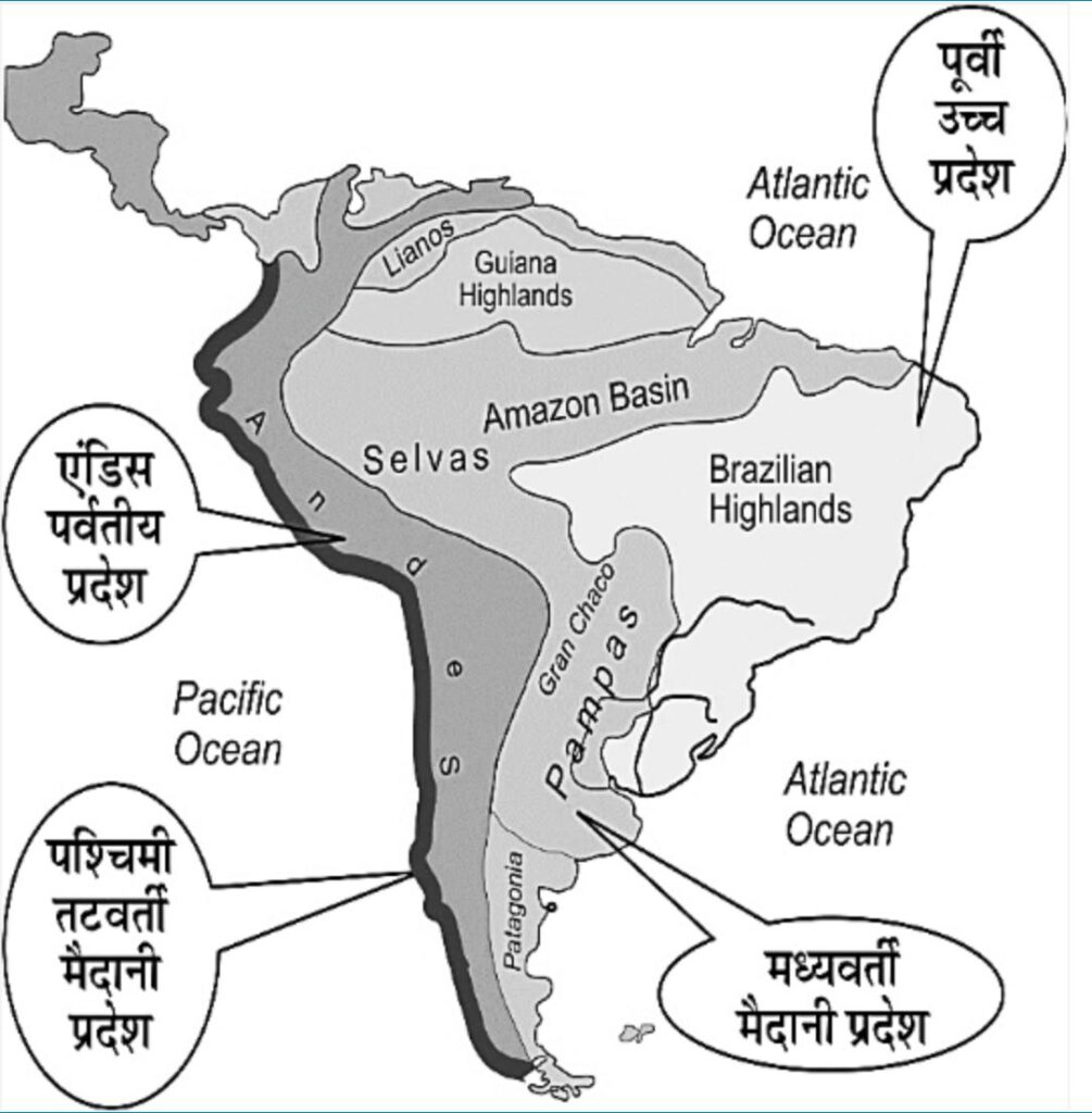
Inter-mediate plains or Inter- mediate lowlands
- Flat, fertile plains located between the Andes Mountains and the Eastern Highlands, covering approximately 45% of South America’s land area.
- Mainly formed by the river basins of the Orinoco, Amazon, and La Plata rivers, all of which originate from the Andes Mountains.
- These plains are divided into three regions based on rivers and plateaus:
- Orinoco Plain – Formed by Orinoco and its tributaries. Most spread in Venezuela. This plain is separated from the Amazon Basin by a narrow interfluve (doab). This is the most fertile plain of South America. The hot grasslands situated here are called ‘Llanos’. Animal husbandry is also done along with petroleum and wheat production.
- La Plata Plain – The plain formed by the La Plata river system is called the La Plata Plain. The flat and fertile plain located south of the Brazilian plateau. Temperate grasslands are found in this plain which are called ‘Pampas’.
Note – The combined water stream of Paraguay, Pilcomayo, Parana rivers is called La Plata. Further Uruguay river also joins it and the combined water of these rivers is discharged into the Rio de Plata Bay.
- Amazon Plain–
- The largest plain in South America. Formation – Created by alluvial deposits from the Amazon River and its tributaries.
- The rainforest in the Amazon Basin is called “Selvas,” inhabited by the indigenous “Boro” tribe.
- The plain is widest near the Andes Mountains and narrows toward its mouth at the Atlantic Ocean.
- The Amazon Basin is the native region of rubber trees.
- Belém Port, located at the mouth of the Pará River in the Amazon Basin, is significant for rubber exports.
- “Anaconda” is a giant snake found in the Amazon Basin.
Pampas grassland
- These are temperate grasslands which are mainly located in Argentina. They are also found in some parts of Brazil and Uruguay.
- Chernozem soil is found in this grassland. It has high humus content and is a black coloured fertile soil.
- The world-famous nutritious grass “Alfalfa” grows here.
- Argentina fattens livestock through grazing, making it one of the world’s leading meat-exporting nations.
- These plains are used for agriculture and animal husbandry, mainly wheat is produced. Hence Argentina is the leading exporter of wheat.
- Bread Basket of South America
- Since the last part of the twentieth century, some parts of the Pampas have been used for grape cultivation. The city of Mendosa in Argentina is famous for wine production.
- Here the cattle farm is called Estancia and the caretaker is called Gaucho.
Salvas
- This grassland is located near the equator in the country of Brazil.
- Salvas is a part of the Amazon Basin of Brazil.
- Rubber trees are found in large numbers here.
Llanos grasslands
- It is located in the countries of Colombia and Venezuela.
- It is a tropical grassland.
Campus
- This tropical grassland is located in Brazil and Argentina.
Gran Chaco
- This tropical grassland is spread in Bolivia, Paraguay and Argentina. Wheat is produced here.
- This is a low marshy land. Forests are being destroyed here for wheat farming.
- ‘Quebraco’ is the main tree of Gran Chaco forests. It is also called axe breaking tree because it is very hard in nature. Tannin acid is obtained from these trees which is used in leather dyeing.
Europe
|
Plain |
Characteristics |
|
Northern Plains of Europe |
|
|
East European Plain |
|
|
Other Plains |
|
Oceania
|
Plain |
Characteristics |
|
Central lowland or central basin area |
Queensland’s Savannah Region
|
|
Nullarbor Plain |
|
|
Wimmera Plains |
|
|
Canterbury Plain |
|
|
Tarana grounds |
|
