

- Formed by the Ghaggar River, which is notable as India’s longest inland drainage river.
- Location: It spans across Sri Ganganagar and Hanumangarh districts in Rajasthan.
- Soil Type: Kathi/Baggi soil, known for its loamy and fertile nature, is predominant in this basin.
- Nali: The basin supports a breed of sheep known as Nali.
- SAM Problem : Intensive agriculture is practiced in this area due to availability of irrigation facility through the Indira Gandhi Canal and Gang Canal. Consequently, the problems of water logging and alkalinity have increased in the area.
Gully erosion is the removal of soil along drainage lines by surface water runoff. When rills (small channels formed by water flow) increase in size, they become gullies.
- When a gully bed is eroded further due to headward erosion, it gradually deepens and flattens out, forming a ravine. Ravines can be quite deep, extending to 30 meters or more.
- Over a large area, gully formation can lead to badland topography, characterized by irregular and deeply eroded landscapes.
Rajasthan : Chambal and its tributaries have considerably eroded the Hadauti plateau. Kota, Sawai Madhopur, and Dholpur districts have suffered from gully erosion.
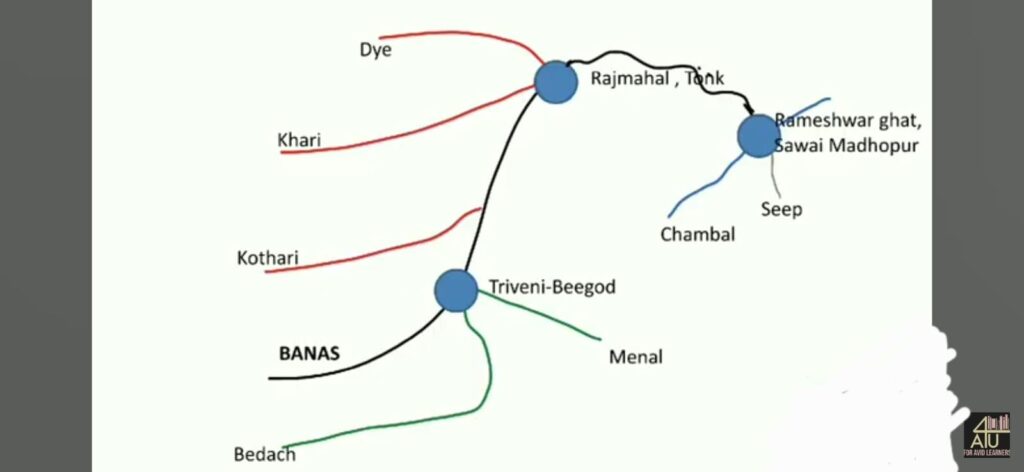
- Banas river is also known as Yamuna of Rajasthan, Van ki Asha or Varnasha.
- Originates from the Khamnor hills of Aravali.
- Flows from the Gogunda plateau southwards from Kumbhalgarh, crosses Nathdwara, Rajsamand Rail Magra, passes through Chittorgarh, Bhilwara, Tonk districts and meets Chambal in Sawai Madhopur.
- Banas is the longest flowing river in the state and the river with the largest catchment area.
- Bisalpur Dam has been built near Todaraisingh town on the banks of Banas River.
Tributaries – The main tributaries on the right side are Bedach, Menal and the main tributaries on the left side are Kothari, Khari, Morel, Dhund etc.
Forms three confluences or Triveni Sangam –
- Rameshwar (Sawai Madhopur): Chambal, Banas and Seep
- Menal (Bhilwara): Banas, Menal, Berach
- Rajmahal (Tonk): Banas, Khari, Dye
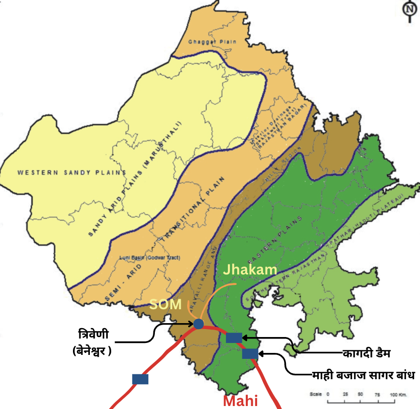
The Mahi Basin, spanning an area of 7,056 square kilometers, encompasses the southeastern region of Udaipur, Dungarpur, Banswara, and the southern part of Chittorgarh district in Rajasthan, India. It is characterized by diverse physical features:
- Terrain and Height: The basin’s elevation varies from 200 to 400 meters above sea level, with undulating landscapes. Salumbar-Sarada area, locally known as Chhappan, and Dungarpur-Banswara area, known as Vagad, are prominent regions.
- Hydrology: The Mahi Basin is drained by the Mahi River and its tributaries, including the Som, Jakham, Kagdar, and Jhamri rivers. Banswara, known as the “Area of Hundred Islands,” owes its name to the presence of numerous rivers.
- Soil Types: The basin is characterized by red loamy soil, suitable for cultivating crops such as maize and rice.
- Tribal Communities: The Mahi Basin is home to indigenous tribes such as the Bhils and Garasiyas, who practice shifting cultivation, locally known as Walra.
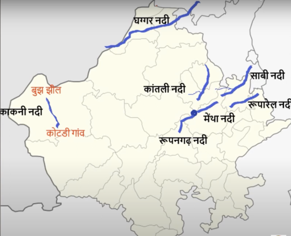
The inland drainage system of Rajasthan comprises numerous small streams that vanish into the sand after a brief surface flow. These rivers occasionally experience flooding due to heavy rainfall.
| River Name | Details |
| Ghaggar Hakra | Origin: Kalka Hills of Himachal Pradesh; flows through Punjab, Haryana, and Rajasthan in India, and finally disappears into the sand dunes of the Bhawalpur district in Pakistan. Scholars link it to the Vedic Saraswati river. |
| Kantli River | Originates from Khandela hills of Sikar district.Flows northward into Jhunjhunu and ends near Churu district.Site of ancient OCP culture – Ganeshwar.; Catchment area known as Torawati |
| Kakni or Masurdi | Small seasonal river of Jaisalmer ; Originates south from Kotri village and drains into Bhuj lake. |
| Mantha River | Originates from Jaipur and flows into Sambhar lake. |
| Ruparel River | Originates from Udainath hills in Alwar and disappears in Bharatpur District.Also known as Varah or Lasvari river. |
| Roopangarh River | originates from the Kishangarh hills. The river flows through Salemabad and Jaipur before finally reaching the Sambhar Lake |
| Sabi | Origin : Sewar Hills of Jaipur; Lost in Plains of Haryana |
| Banganga | Origin : Bairath Hills ; Lost in bharatpur |
| Other | Khari, khandela etc also falls in sambhar lake |
Positive Impacts | Negative Impacts |
On agriculture
On Ecology
| On agriculture
On Ecology
|



