
Western Rajasthan experiences extreme drought due to its
- Arid climate : high temperatures and low humidity, resulting in high evaporation rates and minimal moisture retention in the soil.
- Low rainfall : 0-25 cm annually
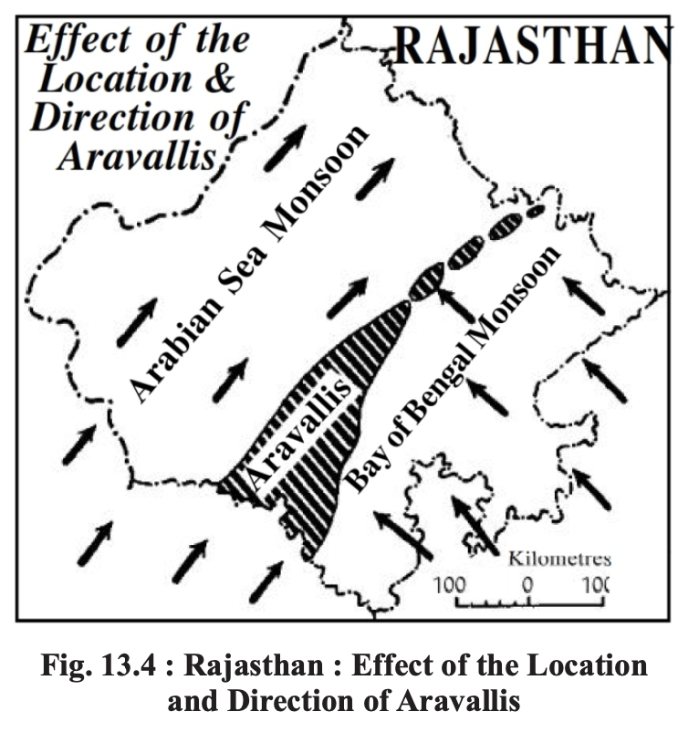
- The presence of the Aravalli Range obstructs moisture-laden winds from reaching the region.
- Extension of Aravallis is parallel to Arabian Sea branch of monsoon which escapes northwards without providing much rain in the state.
- Moisture is considerably reduced in the Bay of Bengal branch of monsoon by the time it reaches Rajasthan.
- Its distance from the sea limits access to moisture, increasing acidity.
- Sparse vegetation further reduces moisture retention, contributing to drought conditions.
- Human Activities: like deforestation have contributed to the degradation of land , worsening drought conditions.
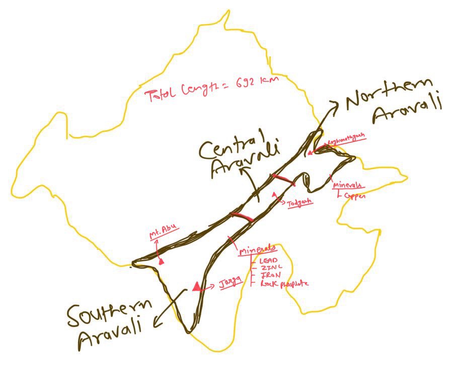
The Aravali Range, approximately 692 km long, is a Pre-Cambrian period old fold mountain range stretching from Palanpur (Gujarat) to Raisina Hills (Delhi). In Rajasthan, it extends from Khed-Brahma in the southwest to Khetdi in the northeast, covering a length of 550 km. It encompasses approximately 9.3% of the state’s area and is home to around 10% of its population.Topographically, the Aravali Range is divided into three physiographic regions:
- South Aravali: (Abu to Ajmer)
- Districts of Sirohi, Udaipur, and Rajsamand.
- Divided into two parts:
- Abu Aravali (in Sirohi, Pali)
- Mewar Aravali (in Rajsamand, Udaipur)
- Main peaks: Gurushikhar (1722m), Ser (1597m), Dilwara (1442m), Jarga (1431m)
- Rivers: Sabarmati (Padrala Hills), Western Banas (Nayasanwara Hills)
- Bhorat Plateau(Kumbhalgarh to Gogunda) is situated here.
- Central Aravali: (Ajmer to Jaipur)
- Districts: Ajmer, southwestern Tonk, Jaipur
- Main peaks: Taragarh (870m), Nag Hills (795m)
- River: Luni River originates from Nag Hills.
- North Aravali: (Jaipur to Jhunjhunu)
- Districts of Jaipur, Dausa, Alwar, Sikar, and Jhunjhunu
- Main peaks: Raghunathgarh (1055m) in Sikar district and Kho (920m) in Jaipur district.
Importance of aravali:
- Economic importance: Aravali is called as “Museum of minerals”. It is home to different minerals i.e., Copper(North Aravali), Lead-Zinc, Iron, Rock Phosphate (Southern Aravali).
- Ecological Barrier: It regulates climate patterns(50cm Isohyet) and prevents desertification, supporting diverse flora and fauna.
- Water Source: Originating numerous rivers and streams i.e.,Luni, Western banas. It provides essential water for irrigation, drinking, and agriculture.
- Biodiversity Hub: Aravali hosts unique plant and animal species, making it a biodiversity hotspot requiring conservation efforts.
- Cultural Heritage: The range is home to ancient forts(Kumbhalgarh fort, Chittorgarh fort), temples, and archaeological sites i.e., Ahad, Bairath, Gilund, representing Rajasthan’s rich cultural heritage.
- Tourism: Its scenic beauty attracts tourists, offering opportunities for trekking, wildlife safaris, and nature exploration.i.e., Mt. Abu.
- Environmental Protection: Aravali acts as a buffer against soil erosion, land degradation, and natural disasters like floods and landslides.
So, Preserving the Aravali Range is vital for sustaining ecosystems, livelihoods, and cultural traditions while ensuring environmental well-being in the region.
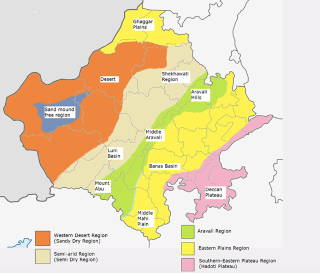
Rajasthan is divided into four physical regions based on relief and climate.
| Desert | Aravalimountain | Eastern PlainArea | Hadoti/MaalPlateau | ||
| Arid | Semi-arid | ||||
| Area % | 61 | 9 | 23 | 7 | |
| Population (%) | 40 | 10 | 39 | 11 | |
| districts(OLD) | 12 | 13 | 10 | 7 | |
| soil | Sandy soil | Mountain soil | alluvial | Light black/cotton | |
| rainfall | 0-20 cm | 20-40 cm | 40-60cm | 60-80 cm | 80-120 |
| climate | Arid and semi arid | Sub humid | humid | Maximum humid | |
| Vegetation(Koppen) | Xerophytes& thorny | Steppe(Largest) | Dry deciduous | Dry and wet | Savana (vagad hadoti +Mt abu) |
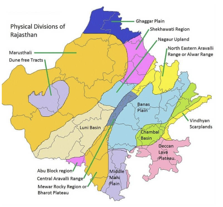
Western Desert Region of Rajasthan
Arid Desert (58.5%)
- Situated to the west of the 25 cm isohyet line
- Encompasses districts: Jaisalmer, Barmer, Bikaner, Jodhpur, and parts of Nagaur and Churu
- Characterized by barchan-type sand dunes and minimal rainfall (0-25 cm)
- Presence of shallow depressions (Rann) :thob, baap, taal chhapar
- temporary lakes (Palaya)
- Abundance of marine fossils indicating the retreat of the tethys sea
- Strategic significance along the Indo-Pak border
- Economic importance due to mineral resources → eg. Barmer Petroliferous basin
Semi-arid Region (41.5%)
- Rocky desert landscapes without sand dune
- Receives 25-50 cm of rainfall
- Subdivision
- Ghaggar basin : Ghaghar → dead river, Clayey and fertile soil
- Shekhawati inland: Inland drainage (Kantli, Mentha etc) , BEED(pasture land), JOHAD, SAR(Ponds during monsoon)
- Nagauri upland : Maximum salt water lakes, HUMP BELT (ajmer-nagaur), Maximum fluoride
- Luni basin : Luni – Lifeline of desert area; Nehad rann; Saline plant (Halophyte)
- Notable for saltwater lakes (such as Sambhar, Deedwana) and high fluoride content.
The Eastern plain area is situated between the Aravallis and the Hadoti plateau. It was formed by sediment brought by rivers during the Pleistocene period. This region covers almost 23 percent of Rajasthan’s area and is home to 39 percent of its population.
Geographical Characteristics:
- Sub-division: It can be divided into 3 parts based on river basins.
- Mahi Plain area: Southern plain area of Rajasthan extending over Banswara, Pratapgarh, and Dungarpur. The plain is formed by the Mahi River and its tributaries. A group of Chappan villages is called the plain of Chappan.
- Banas-Banganga Basin: The plain of Banas and its tributaries is known as the plain of Mewar in the south and the plain of Malpura Karauli in the north. Berach, Khasi, Mansi, Morel, etc., are the main tributaries of the Banas River. The Banganga plain is located in Jaipur, Dausa, Bharatpur.
- Chambal Plain: It is formed by gully erosion of the Chambal River. Its badland topography is known as Ravines/Dang plain. Its extension is in Kota, Bundi, Karoli, Dholpur, and Sawai Madhopur.
- Climate: Humid climate. Its average rainfall is 65 cm.
- Natural Vegetation: Dry deciduous forests are found, e.g., Tendu, khair, babul, sal, teak, mango, sandalwood, etc.
- Soil: Primarily alluvial soil. However, regional variations are found, like red loamy soil in the Vagad region, brown soil in the Malpura-Karauli plain, etc.
Economic Characteristics :
- Agriculture: The plain area benefits from sufficient rainfall and alluvial soil, making it vital for agriculture. Main crops include wheat, rice, mustard, maize, groundnut, green gram, and black gram.
- Irrigation: Wells, ponds, and canals are utilized, along with multipurpose projects on rivers like Mahi and Chambal. The recent approval of ERCP promises further irrigation development.
- Minerals : Non-metallic minerals are prevalent in the area, including garnet in Tonk, mica in the Banas Basin of Bhilwara, emerald in Rajsamand, rock phosphate in Vagad, asbestos, and feldspar in Dungarpur, limestone in Sawai Madhopur and Niwai, and sandstone in Bharatpur, Karauli, and Karuali regions.
- Industries: Industries are sparsely developed, featuring a high-tech glass factory in Dholpur, the Cimmco wagon factory in Bharatpur, and a thriving textile industry in Bhilwara. Tonk is known for its leather factories and other industrial ventures.