
Satellites are an important topic in Science and Technology that involves artificial objects placed in orbit around the Earth or other celestial bodies for various purposes. They play a crucial role in communication, weather forecasting, navigation, remote sensing, and scientific research. Under this topic, we will study different types of satellites, their functions, orbits, and applications in modern technology and daily life.
A satellite is any object that orbits around a larger object due to gravitational forces. Satellites can be natural or artificial, depending on their origin.
Types of Satellites Based on Different Criteria
| Category | Type | Range/Characteristics | ISRO Example(s) |
| A) Based on Mass | Large Satellite | >1000 kg | GSAT Series (Communication Satellites) |
| Medium-Sized Satellite | 500–1000 kg | INSAT-3DR (Meteorological Satellite) | |
| Mini Satellite | 100–500 kg | Indian Mini Satellite -1 (IMS-1) – YouthsatIndian Mini Satellite -2 (IMS-2) – SARAL | |
| Micro Satellite | 10–100 kg | Microsat built by ISRO | |
| Nano Satellite | 1–10 kg | India’s first nano satellite, Jugnu: by IIT Kanpur.ISRO Nano Satellites – INS-1A and INS-1B | |
| Pico Satellite | <1 kg | Student Satellite (STUDSAT) is the first pico-satellite developed in India. | |
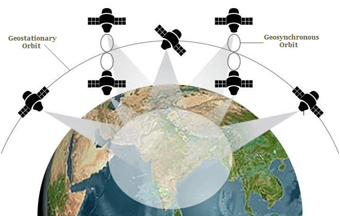
| B) Based on Altitude | Low Earth Orbit (LEO) Satellite | 200–2000 km | Cartosat-2 (Earth Observation) |
| Medium Earth Orbit (MEO) Satellite | 2000–35786 km | NavIC Satellites (Navigation System) | |
| Geostationary Orbit (GEO) Satellite | 35786 km | INSAT-3DR (Meteorological Satellite) | |
| C) Based on Applications | Communication Satellite | GSAT Series (Communication) | |
| Navigation Satellite | NavIC Satellites (Indian Regional Navigation Satellite) | ||
| Remote Sensing or Earth Observation | Cartosat-2, RISAT-1 (Earth Observation) | ||
| Outer Space Exploration or Space Observatory | ASTROSAT (Space Observatory) | ||
1. Communication Satellites (INSAT / GSAT / CMS Series)
- These are typically placed in Geostationary Orbit (GEO) to provide continuous coverage for telecommunication, television broadcasting, and VSAT services.
- INSAT (Indian National Satellite) Series (1982 onwards) → Telecommunication, broadcasting, meteorology.
- INSAT-4 Series (2000s–present): Dedicated for Direct-to-Home (DTH) television broadcasting and communication.
Transition to GSAT and CMS Series
- GSAT Series (2001 onwards) : INSAT nomenclature was changed to GSAT for improved services and technology. High-throughput communication satellites.
- CMS Series: Introduced from 2020 onward for further technological improvements.
| Satellite | Launch Date | Primary Application | Notable Features |
| GSAT-3 | 2004 | Education (EduSat) | Dedicated to satellite-based distance education. |
| GSAT-7(Rukmini) | 2013 | Military communications (Indian Navy) | First dedicated military communication satellite for the Indian Navy. |
| GSAT-7A(Angry bird) | 2018 | Air-to-air and air-to-ground communication (Indian Air Force) | Enhances network-centric warfare for the Indian Air Force. |
| GSAT-8 | 2011 | Communication and navigation (GAGAN) | Provides high-power transponders for DTH and navigation services. |
| GSAT-9 | 2017 | Regional cooperation (South Asia Satellite) | Promotes regional cooperation by providing telecommunication and broadcasting services to South Asia. |
| GSAT-11 | 2018 | Broadband connectivity | Heaviest satellite ever built by ISRO (5,854 kg), enhancing broadband and internet services across rural India and remote regions. |
| GSAT-30 | 2020 | Telecommunication, broadcasting | Replaces INSAT-4A, provides services for DTH, telecommunication, and broadcasting. |
| CMS-01 | 2020 | Communication (Extended-C Band) | Provides services for Indian mainland, Andaman-Nicobar, and Lakshadweep Islands; 42nd communication satellite of India. |
| GSAT-24 (GSAT-N1) | 2022 | Communication, DTH services | 24-Ku band satellite; pan-India coverage for DTH services (Tata Play); first demand-driven satellite mission by NSIL post-space reforms; mission life of 15 years. |
| GSAT-20 (GSAT-N2) | 2024 | Internet (Broadband connectivity) | Launched via SpaceX Falcon-9 in late 2024; India’s first high-throughput satellite for in-flight connectivity and high-speed broadband. |
| GSAT-7R (CMS-03) | November 2025(LVM3-M5) | Dedicated to the Indian Navy. | Heaviest communication satellite (about 4,400 kg) to be launched to GTO from Indian soil. Multi-band (UHF, S, C, and Ku-bands), multi-mission communication Satellite. Provides secure real-time communication across the Indian Ocean Region. |
2. Remote Sensing / Earth Observation Satellites (IRS / EOS Series)
- Most operate in Sun-Synchronous Polar Orbits (SSPO).
- Bhaskara-1 (1979) and Bhaskara-2 (1981) laid the foundation for the indigenous Indian Remote Sensing (IRS) program.
- India’s remote sensing program began with the IRS-1A in 1988.
| Category/Series | Satellites | Description | Applications |
| Resourcesat | Resourcesat-2 & 2A | Crop monitoring, water body mapping. | |
| Cartosat | Cartosat-3 (2019) | Urban planning, high-res 3D mapping. | |
| Oceansat | Oceansat-3 (EOS-06) – 2022 | Sea surface temperature, chlorophyll monitoring. | |
| Oceansat-3A (PSLV N1/EOS-10) | PSLV-N1 (First PSLV built by a HAL/L&T industry consortium). It will operate in tandem with EOS-06 for oceanographic and meteorological studies. | ||
| RISAT Series (Radar Imaging) | RISAT-1A (EOS-04), RISAT-2B & RISAT-2BR1 | All-weather, day/night imaging (including through cloud cover) for agriculture/forestry. | |
| EOS Series (Modern Standard) | EOS-01 (Nov 2020) | Used for agriculture, forestry, and disaster management. | |
| EOS-04 (RISAT-1A, Feb 2022) | Provides high-quality images in all weather conditions. | ||
| EOS-06 (Oceansat-3, Nov 2022) – PSLV-C54 | Focused on ocean colour, sea surface temperature, and wind vector data. | ||
| EOS-07 (Microsat-2B, Feb 2023) – SSLV-D2 | Microsatellite for various Earth observation applications. | ||
| EOS-08 (Aug 2024) – SSLV-D3 | Microsatellite carrying infrared (EOIR) and navigation reflectometry (GNSS-R) payloads. | ||
| EOS-N1 (Anvesha) | Jan 2026, Failed | ||
| EOS-10 (Oceansat-3A) | Mar 2026 | ||
| NISAR/GSLV-F16 | ISRO-NASA joint mission | L-Band and S-Band radar imaging. |
NASA–ISRO Synthetic Aperture Radar (NISAR) mission
- Dual-frequency Radar: NASA (L-band SAR) + ISRO (S-band SAR).
- World’s first dual-band radar satellite for Earth observation.
- Launch: GSLV Mk-II (GSLV-F16) from Sriharikota.
- Orbit: Sun synchronous, Polar (747 km altitude).
- Technique: SweepSAR for beam steering without sacrificing resolution.
- Microwave imaging mission → acquire fully polarimetric and interferometric data.
- Coverage: Revisits every location on Earth every 12 days.
- Structure:
- 12-meter deployable mesh antenna
- 9-meter boom for scanning.
- Objectives
- Measure global land surface changes (ecosystem, ice-sheet collapse, earthquakes, landslides, volcanoes).
- Monitor hazards, sea level, groundwater, biomass for disaster & climate management.
- Detect crust & frozen region shifts with cm-level accuracy.
- Promote global scientific collaboration & open data access.
TRISHNA: Thermal Infrared Imaging Satellite for High-Resolution Natural Resource Assessment.
- Joint mission: ISRO (India) and CNES (France).
- Focus: High-resolution thermal infrared imaging to study Earth’s surface temperature and water stress.
- Objectives:
- Monitor Land Surface Temperature (LST).
- Assess water stress in crops.
- Track droughts, heatwaves, and evapotranspiration.
- Payloads:
- TIR Instrument (Thermal Infrared Sensor) – French.
- Visible + Near-Infrared Sensor – ISRO.
- Key Features:
- High-resolution (50–60 m).
- Revisit time: 3 days.
- Covers land, coastal zones, and shallow waters.
Major International Earth Observation Satellites
- Landsat 9 (NASA + USGS) (Sep 2021)
- Sentinel Series (ESA – Copernicus Programme) – India is also a partner.
- Sentinel-6 Michael Freilich (Nov 2020) – Sea-level tracking via radar altimetry.
- Sentinel-1C & 2C – Upcoming satellites expanding Earth observation.
- Sentinel-6B Satellite
- An advanced ocean-altimetry satellite launched via SpaceX Falcon-9.
- Joint mission of NASA, NOAA, ESA, Eumetsat, European Commission, with support from CNES.
- Gaofen Series (China) (2020–2023)
- GOSAT-2 (Greenhouse Gases Observing Satellite) – Japan – JAXA
- KOMPSAT-6 (South Korea) (2022).
Sentinel-6B Satellite
- An advanced ocean-altimetry satellite launched via SpaceX Falcon-9.
- Joint mission of NASA, NOAA, ESA, Eumetsat, European Commission, with support from CNES.
- Objective: It measures sea-surface height, waves, winds, and ocean dynamics to provide continuous, high-accuracy data essential for improved climate forecasting and coastal planning.
3. Navigation Satellites
- Navigation Satellites provide positioning, navigation, and timing (PNT) services.
- Navigation systems are of two types
- Global
- Regional.
- GPS is the oldest, Galileo the most accurate, BeiDou the largest constellation.
- Navigation satellites are mostly placed in MEO (except NavIC, QZSS, BeiDou mix).
Presently, there are four global satellite-based navigation systems:
| Country | Navigation System | Number of Satellites |
| USA | Global Positioning System (GPS) | 31 |
| Russia | Global Navigation Satellite System (GLONASS) | 24 |
| China | BeiDou Navigation Satellite System (BDS) | 35 |
| European Union | Galileo | 26 |
Regional navigation systems
- QZSS (Quasi-Zenith Satellite System): Japan
- NavIC (Navigation with Indian Constellation): India
- KPS (Korean Positioning System): South Korea (under development).
Indian Navigation Satellite System
- ISRO provides independent satellite-based navigation for civil aviation and general user needs.
- India’s major navigation systems:
- IRNSS (Indian Regional Navigation Satellite System) / NavIC – for national positioning services.
- GAGAN (GPS Aided GEO Augmented Navigation) – for civil aviation.
- GEMINI – Alerts to fishermen.
1. NavIC (ISRO’s Regional Navigation System)
- Developer: Indian Space Research Organisation
- Earlier known as Indian Regional Navigation Satellite System – IRNSS.
- Coverage: India + up to 1,500 km around borders.
- Constellation: 7 satellites (Currently 11)
- 3 in Geostationary Orbit (GEO)
- 4 in Geosynchronous Orbit (GSO)
- Services: 2 types of services
- Standard Positioning Service (SPS) → for civilian use.
- Restricted Service (RS) → encrypted, for defence & strategic use.
Recent Developments
- Next-Generation NavIC Satellites (NVS Series) – Part of second-generation NavIC satellites.
- NVS-01: Launched (2023) on GSLV Mk-II (GSLV-F12) → 2nd generation with indigenous atomic clock.
- L1 navigation band → compatible with global GNSS devices (esp. smartphones, consumer tech).
- NVS-02: launched (Jan 2025) on GSLV-F15 → Strengthens constellation reliability (only 4/7 earlier satellites fully functional).
- NVS-03 (GSLV-F17), NVS-04, NVS-05 planned by 2026 → Boost coverage & accuracy.
- NVS-01: Launched (2023) on GSLV Mk-II (GSLV-F12) → 2nd generation with indigenous atomic clock.
- Accepted by International Maritime Organization (IMO) as part of World Wide Radio Navigation System (WWRNS) → merchant vessels can now use NavIC (like GPS & GLONASS) for ocean navigation.
- Mandatory NavIC support in smartphones (2025 onwards) → Boosts civilian adoption.
- Deadlines: 5G phones must feature NavIC support by January 1, 2025; non-5G phones by December 2025.
- Coverage Expansion: From 1,500 km → 3,000 km beyond Indian borders.
- Global Ambitions: Work initiated on GINS (Global Indian Navigation System) → satellites in Medium Earth Orbit (MEO) for global reach.
2. GPS Aided GEO Augmented Navigation (GAGAN)
- Type: Satellite-Based Augmentation System (SBAS).
- Jointly Developed By: ISRO & Airport Authority of India (AAI).
- Objectives:
- High-accuracy satellite-based navigation for civil aviation.
- Better Air Traffic Management over Indian airspace.
- Interoperable with global SBAS for seamless navigation.
- Signal-in-Space (SIS): Provided via GSAT-8 & GSAT-10 satellites.
3. Gagan Enabled Mariner’s Instrument for Navigation and Information (GEMINI)
- Type: Satellite-based communication device (handheld) launched in 2019.
- Developed by: AAI + ISRO + INCOIS (Indian National Centre for Ocean Information Services).
- Uses GAGAN satellites to transmit data.
- Services Provided:
- Real-time weather alerts (cyclones, storms, high waves).
- Navigation information for safe fishing routes.
- Emergency communication when mobile networks are unavailable.
- Coverage: Entire Indian Ocean region within GAGAN footprint.
- Target Users: Fishermen, coastal communities, maritime operators.
4. Space Science & Exploration (Interplanetary Missions)
- These are “Other” category missions that focus on deep space and scientific discovery.
- Interplanetary Missions: Space missions beyond Earth orbit, aimed at exploring the Moon, Mars, Sun, asteroids, and deep space.
Moon Missions
India’s Moon Missions
Aspect | Chandrayaan 1 | Chandrayaan 2 | Chandrayaan 3 |
Launch year | 2008 | 2019 | 2023 |
Objectives | Study lunar surface |
|
|
Component | Orbiter |
|
|
Launch Vehicle | PSLV C11 |
|
|
Landing site | Jawahar Sthal |
|
|
Payloads | MIP (Moon Impact Probe) |
|
|
Technology Validation |
|
| |
Achievments | Discovered water molecules on the lunar surface. |
|
|
Key Achievements of Chandrayaan 3
- India → 4th country to soft-land on Moon (after USA, USSR, China).
- India → 1st country to land at lunar south pole → major milestone.
- Confirmed presence of water ice in multiple sites.
- Propulsion module tested lunar return trajectory → aids Chandrayaan-4.
Future Moon Missions
- Chandrayaan-4 (Approved in 2024)
- ISRO’s proposed mission to collect lunar samples from the lunar south pole and bring them back to the Earth.
- Components: Ascender Module (AM), Descender Module (DM), Re-entry Module (RM), Transfer Module (TM), and Propulsion Module (PM).
- Launch vehicle: Two separate LVM3.
- Chandrayaan-5/LUPEX (Lunar Polar Exploration)
- Planned joint lunar mission by ISRO and Japan Aerospace Exploration Agency (JAXA).
- Expected to be launched in 2026 or later.
- Objectives: Explore the Moon’s surface, search for water, and consider future human activities on the Moon.
- JAXA will provide the rover and launch vehicle, while ISRO will provide the lander.
- Manned Moon Landing: Targeted for 2040, using the indigenous NGLV (Soorya) rocket.
Moon Missions of Other Countries
Mission | Description |
Artemis Mission |
|
Chang’e Program |
|
ILRS (International Lunar Research Station) |
|
SLIM (Smart Lander for Investigating Moon) or “Moon Sniper” |
|
Beresheet |
|
Luna-25 |
|
Rashid 2 |
|
Sample return missions from Moon
- Chang’e-5, Chang’e-6 (China), Apollo missions (NASA), Luna 16, 20, 24 and 25 (Russia).
Solar Missions
Aditya-L1 Mission (2023)
- Mission: India’s first solar observatory-class mission.
- Orbit: Halo orbit around Lagrange Point L1 (about 1.5 million km from Earth)
- Orbit advantage: Continuous, uninterrupted observation of the Sun (no eclipses/occultations).
- Scientific objectives:
- Study solar atmosphere (chromosphere & corona) dynamics.
- Investigate coronal heating, solar flares, CME initiation.
- Observe in-situ plasma & particles near L1.
- Study drivers of space weather (solar wind origin, composition and dynamics).
- Payloads: Total 7 (5 by ISRO and 2 by Indian Academic institutes.
- Remote Sensing Payloads
- Visible Emission Line Coronagraph (VELC)
- Solar Ultraviolet Imaging Telescope (SUIT)
- Solar Low Energy X-ray Spectrometer (SoLEXS)
- High Energy L1 Orbiting X Ray Spectrometer (HEL1OS)
- In-situ Payloads
- Aditya Solar wind Particle Experiment (ASPEX)
- Plasma Analyser Package For Aditya (PAPA)
- Advanced Triaxial High Resolution Digital Magnetometers.
- Remote Sensing Payloads
ESA’s Proba-3 Mission with ISRO
- Agency: European Space Agency (ESA).
- Launch Vehicle: PSLV-XL (PSLV-C59), by ISRO.
- Orbit: High elliptical orbit, apogee about 60,000 km from Earth.
- Mission type: In-Orbit Demonstration (IOD)
- Objective: Demonstration of precise formation flying in space.
- Science goal: Observation of the solar corona using innovative satellite formation flight
- Other Points:
- ESA’s first launch from India since Proba-1 (2001).
- First-ever precision formation flight mission → two satellites acting like a giant coronagraph (one blocks the Sun’s disk, the other observes the corona) → to allow uninterrupted observation.
- Corona is the outermost part of the Sun’s atmosphere.
Important Solar Missions
Solar Mission | Features / Purpose |
Solar and Heliospheric Observatory (SOHO) |
|
Solar Orbiter (SolO) |
|
Parker Solar Probe |
|
STEREO |
|
Kuafu-1 Solar Probe |
|
Aditya L-1 |
|
SMILE (Solar wind Magnetosphere Ionosphere Link Explorer) |
|
NASA: SunRISE (2024) – Sun Radio Interferometer Space Experiment |
|
Xihe-2 (Proposed 2026-28) |
|
Interstellar Mapping and Acceleration Probe (IMAP) |
|
PUNCH (Polarimeterto Unify the Coronaand Heliosphere) |
|
Venus Missions
Venus Orbiter Mission (Shukrayaan Mission)
- The Venus Orbiter Mission of ISRO is scheduled to launch in March 2028.
- India’s second interplanetary mission after the Mars Orbiter Mission (Mangalyaan) launched in 2013.
- It is only an orbiter mission.
- Goal: To explore the planet’s atmosphere, surface, and its interaction with the Sun.
- It will carry the first ground-penetrating radar to Venus.
- Shukrayaan-I will be launched on either GSLV Mk II or GSLV Mk III.
- The mission will use the aerobraking technique to achieve a low-altitude orbit.
- The scientific payloads / experiments : 16 Indian payloads, 2 Indian and international collaborative payloads, and one international payload.
- Indian payloads:
- S-Band Synthetic Aperture Radar for Venus mission (VSAR)
- Venus Surface Emissivity and Atmospheric Mapper (VSEAM)
- Lightning Instrument for VEnus (LIVE)
- VEnus THermosphere Ionosphere composition Analyser (VETHICA)
- Venus Advanced Radar for Topside Ionosphere and Subsurface Sounding (VARTISS)
- Venusian Electron temperature and Density Analyser (VEDA)
- Venus Ionospheric Plasma wave detectoR (VIPER)
- Venus Radiation environment monitor (VeRad)
- Venus Orbit Dust Experiment (VODEX)
- Indian and international collaborative payloads
- Venus Ionospheric and Solar Wind particle AnalySer (VISWAS)
- Radio Anatomy of Venus Ionosphere (RAVI)
- International payload
- VIRAL (Venus InfraRed Atmospheric gases Linker)
- Indian payloads:
Other Venus Missions
Country / Organization | Mission Details / Objectives |
NASA |
|
ESA |
|
Japan |
|
Russia |
|
China |
|
Other Important Interplanetary Missions
Important Mars Missions
| Country | Active/Recent | Upcoming (2028-2030) |
| India | Mangalyaan-1 (2013, Ended) | Mangalyaan-2 (Lander/Rover) |
| USA | Perseverance, Curiosity, MAVEN (NASA has lost contact). | Mars Sample Return |
| China | Tianwen-1 (2021)Orbiter + Zhurong rover.First nation to achieve orbit + landing + rover in one mission. | Tianwen-3 (Sample Return) |
| Europe | Trace Gas Orbiter (TGO) | Rosalind Franklin Rover |
Other Important Missions
Mission | Description |
Jupiter Icy Moons Explorer (JUICE) Mission |
|
OSIRIS REx |
|
Double AsteroidRedirection Test(DART) |
|
Lucy Mission (NASA) |
|
Cassini Spacecraft |
|
