
In Indian Geography, the Northern and North-Eastern Himalayas, stretching across states like Himachal Pradesh and Arunachal Pradesh, form a majestic mountain range shaping India’s climate and biodiversity. These rugged peaks influence settlement patterns and economic activities in the region.
General Introduction
- A series of many parallel or convergent ranges.
- It is spread from Jammu and Kashmir in the north-west to Arunachal Pradesh in the east in a length of about 2400 km and an area of 5 lakh sq km.
- Formation – It is caused by the Alpine geo-movement of the Tertiary period.
- The western part is wider than the eastern part, which is about 400 km wide in the west and about 150 km wide in the east. Reason – The pressure force on the convergent frontier in the east is higher.
- The eastern Himalayas are higher due to higher pressure force in the east. This is why high peaks like ‘Mount Everest’ and ‘Kanchenjunga’ are located in the eastern Himalayas. Along with this, the Himalayan ranges have become convex towards India and concave towards Tibet.
- On an average , the areas raised above 5000 m are always covered with snow. However, the height of the snow line in the western part of the Himalayas is 5700 m and in the eastern part it is 4200 m.
- The mountain range is made up of many ranges. Plateaus and valleys are found in between these ranges. The slope of these ranges is steep towards India and gentle towards Tibet.
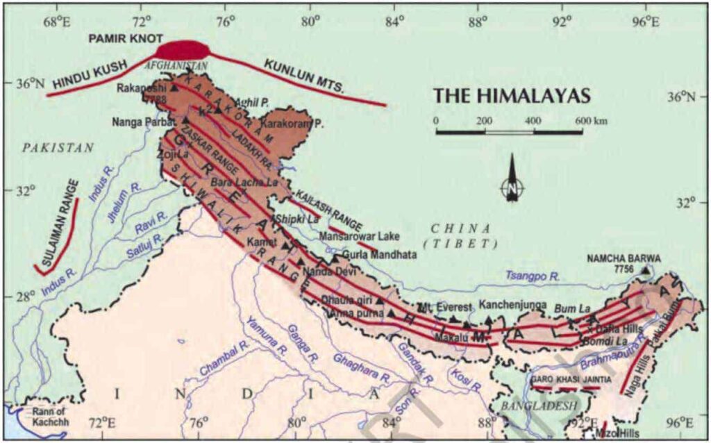
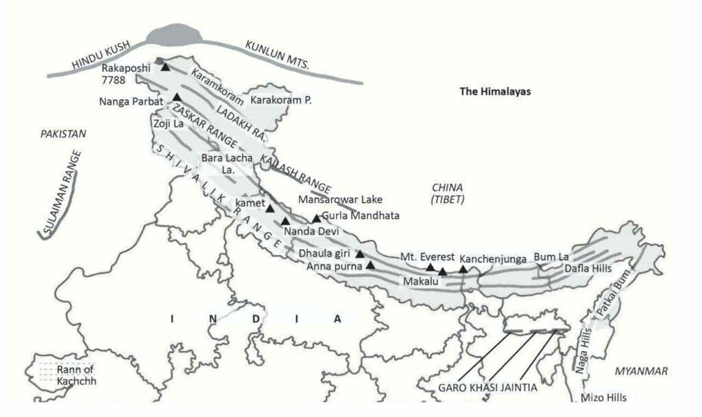
- The northern mountainous region extending from north to south can be divided into the following parts –
- Trans Himalaya
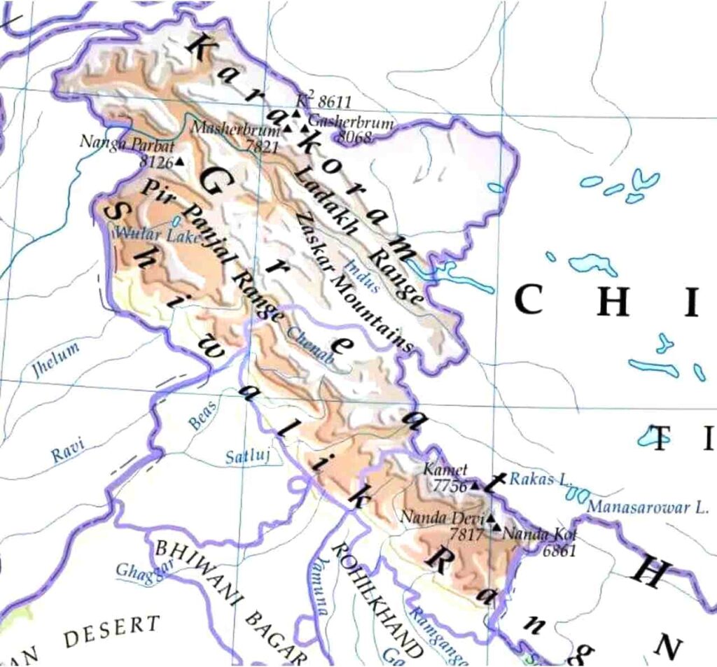
- Karakoram Range
- Ladakh Range [extends to Mount Kailash in Tibet]
- Zaskar Range
- Main Himalayas
- Greater Himalayas or Inner Himalayas
- Lesser Himalayas or Middle Himalayas
- Shivalik or Outer Himalayas
- North-Eastern Himalayas.
Origin of Himalayas
- Complex mountain system
- Pre-Cambrian to Eocene age rocks present.
- Laminated and metamorphic rocks
- The rocks are full of folds and faults.
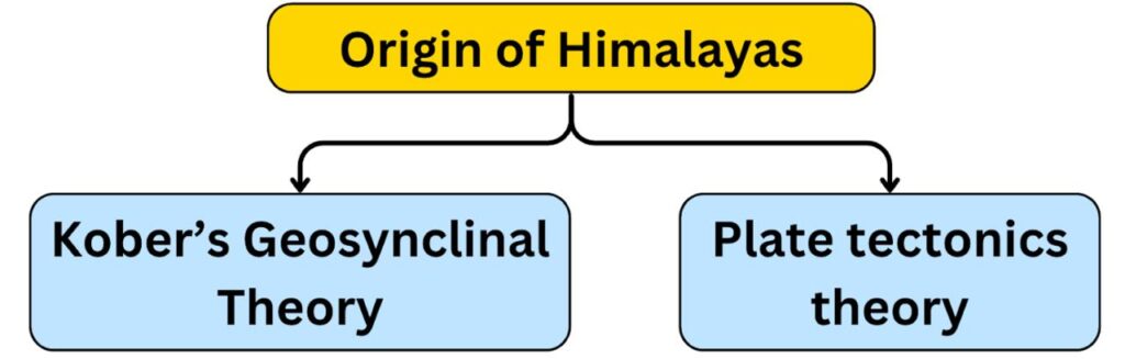
Kobar’s land inheritance theory
- Supporters- Prof. Arangad, Kober, Suves.
- Kober has called the geosynclines as the cradle of mountains.
- Geosyncline – It refers to a long, narrow, and shallow sea.
- According to Kober, in the Mesozoic era, in place of Himalayas, there was Tethys geosyncline, to the north of which were the forelands called Angaraland and to the south Gondwanaland.
- Due to the rivers flowing from the front regions, sediments kept getting deposited in the Tethys tectonic plate. Although the tectonic plate is shallow, its bottom keeps sinking due to the pressure of the deposited sediments.
- As a result of the sinking of the bottom of the Tethys tectonic plate, pressure-induced land movements occurred in both the adjacent forelands and the Himalayas were formed due to the folding of the sediments. The intermediate region/middle mass which was unaffected or less affected by the folding is located in the form of the Tibetan plateau.
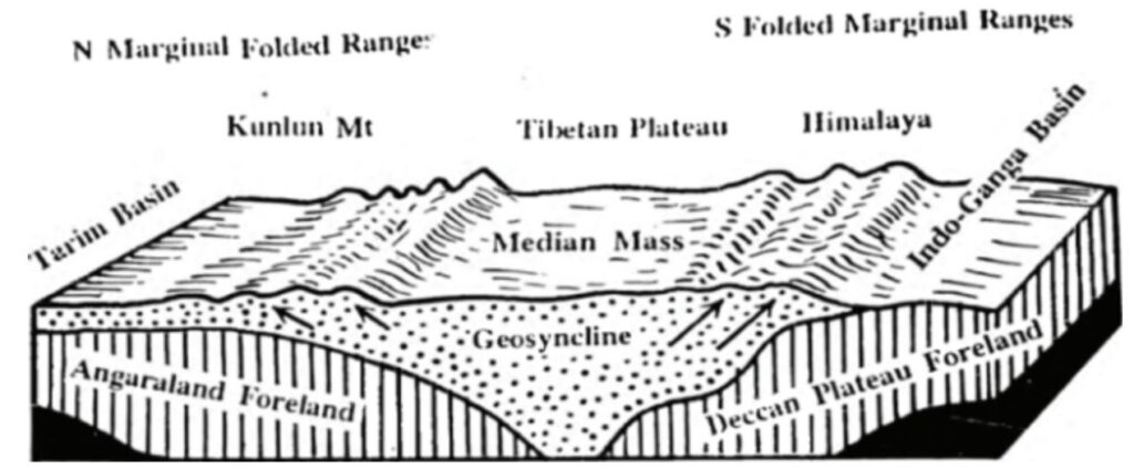
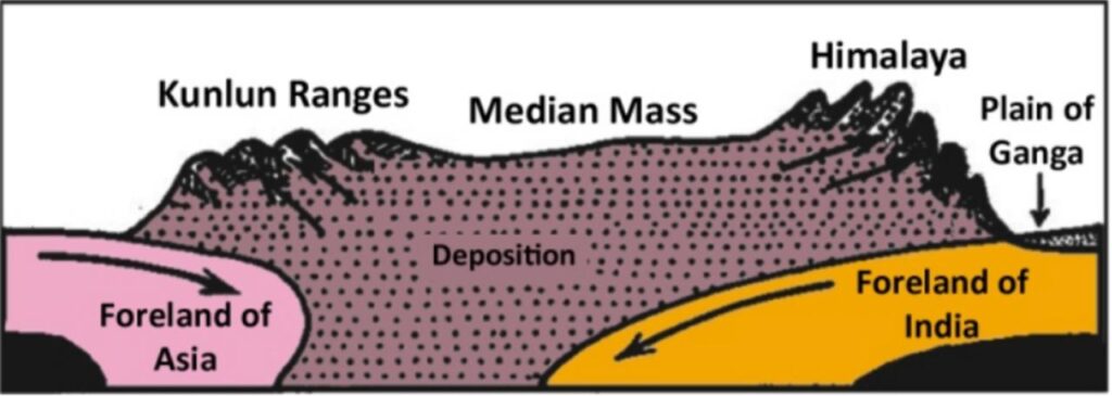
Plate tectonics and the origin of the Himalayas
- Plate tectonics theory- 1967 (B.J. Morgan)
- Basis – Sea level spreading presented by H.H. Hess.
- According to the plate tectonics theory, the Himalayas originated due to the collision between the Eurasian plate and the Indian plate and the folding of the sediments of the ‘Tethys Sea’ situated between these two plates.
According to this theory
- 65 million years ago, at the place of the Himalayas, there was a wide plateau – actually a landmass – Tethys Sea.
- Since the Carboniferous period, the peninsular India has been moving north and northeastwards.
- As a result, the Indian plate collided with the Eurasian plate, causing a shock wave which started the uplift of the Himalayas.
- Stages of uplift
First phase – began about 65 million years ago.
- Granite rose upwards.
- Ladakh and Zaskar mountains were formed.
- Note: Ladakh and Zaskar of Trans Himalayas also originated from the upliftment of the remains of Tethys Sea.
- Due to the upliftment of the deposits and sediments collected in the Tethys Sea during the main phase of Himalayan orogeny.
- The floor of the Tethys Sea of the Indian superposition sank downwards and the Great Himalayas originated due to the northward movement of the Indian plate.
- The Tibet Plateau played a special role in this process. The Tibet Plateau is hard, strong and vast and its presence led to the upliftment of large deposits.
- The upliftment of the Great Himalayas created a suture between the Himalayas and the Jaskar and Ladakh ranges which is called the Indus Suture.
Second phase: Lesser Himalayas were formed 45 million years ago.
- This era gave rise to steep, gently sloping ranges including the Pir Panjal, Dhauladhar, Karol and Mahabharat ranges.
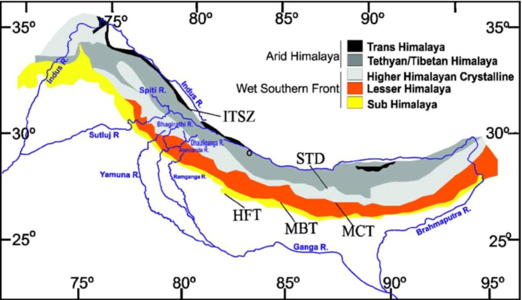
- Main Central Thrust (MCT) separates the Greater Himalayas and the Lesser Himalayas.
- The formation of the mountain spurs of the Lesser Himalayas led to the formation of many mountain-thrust basins. Kashmir Valley, Karol Basin, Doon Valley, Kathmandu Valley.
- During this period, deposits and sediments continued to accumulate in the Foredeep. These deposits formed the Shivalik/Outer Himalayas [between the Miocene and Pleistocene periods (1.4 million years ago)].
- The Main Boundary Thrust (MBT) separates the Lesser Himalayas and the Shivalik.
- The Himalayan Front Fault (HFF) separates the Shivalik from the plains of northern India.
- Included folds are found in the Shivalik which are similar to the Jura Mountains
North to south division
A. Trans Himalaya
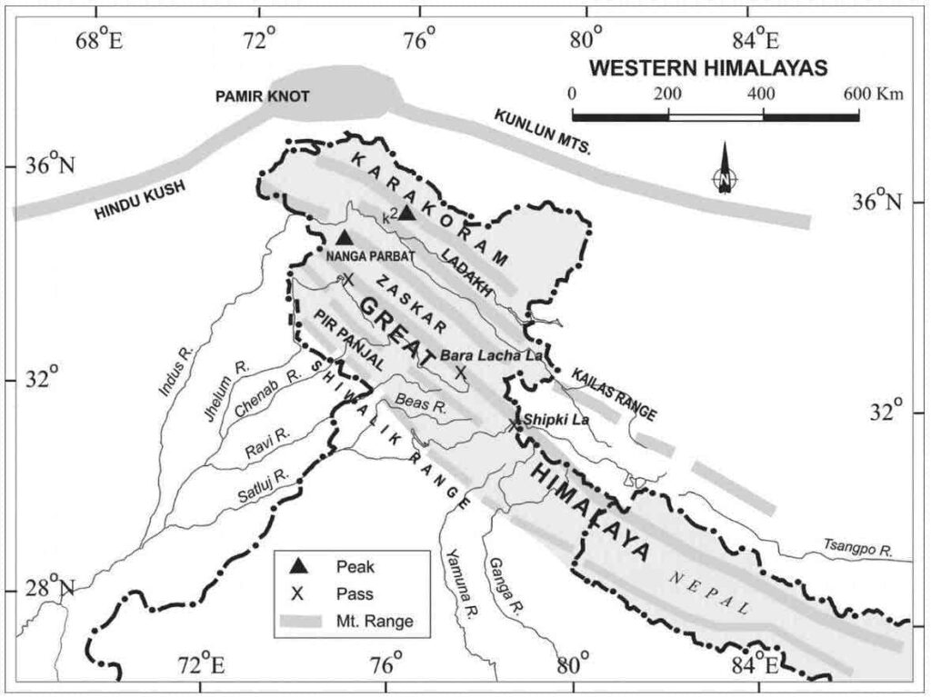
- The northernmost part of the Himalayan mountain region is primarily located in Ladakh and Tibet. It is also known as the Tibetan Himalaya.
- Extended from north-west to north-east for a distance of about 1000 km. The average width is 40 km at the edge and about 225 km in the middle. The average height is about 4000 m.
- Remnants of the Tethys Sea exist, which contain fossils of marine organisms and marine vegetation.
- It was formed before the Great Himalayas, granite is present under the layered rocks here.
- Located in the rain shadow region of the main Himalayas ➟ Dry conditions are found here and there is a lack of vegetation.
- Trans Himalaya is separated from the Greater Himalayas by the ITSZ (Indus-Tsangpo Suture Zone).
- Jaskar, Ladakh, Kailash and Karakoram are the main mountain ranges.
1. Karakoram Range (other name – Krishnagiri Range) –
- The northernmost range of Trans Himalaya.
- ‘The backbone of High Asia’.
- The Karakoram range merges with Pamir Knot in the west and Kailash range in the east.
- It is the highest range of Trans Himalaya. Mount Godwin Austen (K-2) (8611 m) is the second highest peak in the world and the highest peak in India, located in Pakistan Occupied Kashmir (POK).
- The range is famous for alpine glaciers such as Siachen (72 km), Batura, Hispar (61 km), Biafo (63 km), Baltero (62 km) etc.
- Nubra River originates from the Siachen Glacier.
Note – Nubra Valley, a three-armed valley formed by the confluence of Shyok and Nubra rivers, is situated between the Karakoram and Ladakh ranges. The ancient local name of the valley was Dumra (Valley of Flowers). Two-humped camels are found in the valley area and it is a cold dry desert area.
2. Ladakh Range –
- The range is situated to the south of the Karakoram range. Its extension is known as Mount Kailash in Tibet. Lake Mansarovar is situated to the south of Mount Kailash.
- The highest peak is Rakaposhi (7788m).
- Khardung La is the main pass situated in this range which connects Shyok and Nubra river valleys to the Indus river valley.
- The Ladakh plateau is situated between the Karakoram and Ladakh ranges, which is an intermountain plateau. It is the highest plateau of India, where cold dry desert conditions are found. Many saline lakes are located in the plateau region. [Pangong Lake – An issue of dispute between India and China]
- Several plains are located – Soda Plains, Aksai Chin, Lingzi Tang, Depsang Plains and Chang Chenmo.
3. Jaskar Range
- The southernmost range of the Trans Himalayas which is joined to the Greater Himalayas due to the high compressional force of the Himalayas.
- The range extends from the Suru River valley in the northwest to the Karnali River in the southeast.
- Highest peak – Kamet [in the Uttarakhand Tibet border region]
- The Indus River flows between the ‘Jaskar’ and ‘Ladakh’ ranges and cuts the Ladakh range at a place called ‘Bunji’ forming ‘India’s deepest gorge’ (about 5,200 m deep).
B. Main Himalayas
- The second part of the Himalayan mountainous region which is situated to the south of the Trans Himalayas. The Indus-Tsangpo Circulation Zone is situated between the Trans Himalayas and the Main Himalayas.
- Expansion – India, Nepal, Tibet and Bhutan.
- The Syntaxial Mode is situated on both sides of the Main Himalayas. The two folded arms of the Himalayas are spread in the form of Hindukush, Suleman, Kirthar ranges in the west and Purvanchal and Arakanyona mountain ranges in the east.
1. Greater / Inner / Great Himalayas
- Due to being always covered with snow, it is also known as Snowy Himalayas or ‘Himadri’.
- Expansion – From Nanga Parbat/Indus River Gorge in the west to Namcha Barwa Mountains in the east as a continuous range.
- The Himalayas are composed of parallel ring ranges, of which the Greater Himalayas is the oldest range.
- The Greater Himalayas are separated from the Lesser Himalayas by MCT (Main Central Thrust).
- Average height – About 6,100 m and average width is 25 km. This range is tectonically active, hence it is still rising.
- The mountain slope of the Greater Himalayas is gentle towards the north and steep towards the south. Reason – Convergent force applied by the Indo Australian plate.
- Due to the steep slope of this range towards India, the river valleys are narrow and have steep slopes. Rivers like Indus, Sutlej, Ganga, Yamuna, Brahmaputra etc. originate from here.
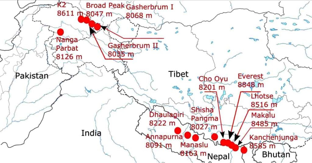
- The world’s highest peaks are located in this mountain range.
| Some of the highest peaks of the Himalayas | ||
| Peak | Country | Height(m) |
| Mount Everest [‘Sagarmatha’ (Nepal), Chomolungma in Tibetan] | Nepal | 8,848 [Highest peak in the world] |
| Kanchenjunga [highest peak of the Himalayas in India] – located on the Sikkim-Nepal border | India | 8,598 |
| Makalu | Nepal | 8,481 |
| Dhoulagiri | Nepal | 8,172 |
| Nanga Mountain | India | 8,126 |
| Annapurna | Nepal | 8,078 |
| Nanda Devi | India | 7,817 |
| Kamet | India | 7,756 |
| Namcha Barua | India | 7,756 |
| Gurula Mandhata | Nepal | 7,728 |
| Kedarnath | India | 6945 |
- The range has glaciers like Gangotri, Yamunotri, Satopath, Pindar, Milan, Bandarpoonch, Barasikri, Nandak, Zemu from which the major rivers of India originate.
- This is a continuous range in which many passes are found for the convenience of transportation. In North India, passes are called ‘La’ in the local language. Zojila, Burjila, Baralacha, Shipkila, Thang La, Mana La, Niti, Lipulekh La, Naku La, Nathu La, Jelep La etc.
- Pilgrimage sites – Badrinath, Kedarnath, Amarnath, Hemkund Sahib, Tawang.
- Peaks in Uttarakhand from west to east – Bandarpoonch, Badrinath, Kameth, Dunagiri, Nanda Devi, Trishul, Dujagiri.
- Physical weathering is more in the Greater Himalayas and erosion is less.
- Igneous and metamorphic rocks are predominant in the Greater Himalayas – granite, schist, gneiss are in abundance. Archaean rocks are present in the base layer.
2. Small / Middle / Himachal Himalaya (Lesser Himalayas)
- Extension – South of the Greater Himalayas.
- The mountain range is about 50 km wide and 3,700 m to 4,500 m high on an average. MCT structure is found in its north and MBF structure in the south.
- Kashmir valley, Lahaul – Spiti, Kullu and Kangra valleys are situated between the Greater and Lesser Himalayas.
- The lake deposits found in the Kashmir valley are called Karewa. Thick deposits of glaciers and sediments brought by rivers are also present in them. Saffron, almonds, walnuts, apricots and apples are cultivated well in it.
- The Lesser Himalayas are divided into the following ranges from west to east-
- Pir Panjal Range – Jammu and Kashmir (Longest range of the middle Himalayas – Banihal and Pir Panjal Pass located)
- Dhauladhar Range (Himachal Pradesh) – Here are the famous valleys of Kangra and Kullu. It is a mountainous region situated to the south of Pir Panjal.
- Nag Tibba – Situated to the west of Kali River in Uttarakhand, Kedarnath, Badrinath are located.
- Mussoorie Range (Uttarakhand)
- Mahabharat Range (Nepal) – Lesser Himalayas spread to the east of Kali River, Kathmandu Valley in Nepal between Greater Himalayas and Mahabharata.
- Dokya and Black Mountain ranges are part of this mountain range.
- Coniferous forests are found on the higher slopes of this range and grasslands are found on the lower slopes, which are called Merg [Gulmarg, Sonamarg etc.] in Kashmir and Bugyal and Payar [Bedla, Ali, Barnala] in Uttarakhand.
- These temperate grasslands are alpine pastures where local communities bring their animals for grazing. These grasslands are covered with snow during winter.
- This range has passes like Pir Panjal and Banihal and many tourist places like Shimla, Manali, Nainital, Ranikhet, Dharamshala, Mussoorie etc.
- The Lesser Himalayas have become more balanced and stable from the tectonics point of view. Many examples of river capture are found here.
- Seasonal migration – seasonal movement of cattle herders with their animals. Local Samudas migrate seasonally in search of fodder and water. Gujjars and Bakarwals migrate seasonally in the Himalayan region.
- Animal Husbandry Castes–
- Gujjar, Bakarwal (Jammu Kashmir)
- Gaddi (Himachal Pradesh)
- Lepcha (Sikkim)
- Bhutia (Darjeeling)
3. Shivalik / Outer Himalaya
- The southernmost range of the main Himalayas. The Shivalik range is less high as compared to other ranges of the Himalayas.
- This range is located in a fragmented manner. The height of the range is 900 to 1100 m and the width is 10 to 50 km.
- Shivalik has originated due to the deposition and folding of the sediments brought by the rivers originating from the Himalayas. It is also the newest mountain range of the Himalayas.
- Expansion – From Potwar Basin of Pakistan to Dihang of Assam.
- There are many flat structural valleys between the Shivalik and the Lesser Himalayas. In the west they are called ‘Doon’ and in the east they are called ‘Dwar’, such as Dehradun, Kotlidoon, Patlidoon, Nihang Dwar and Haridwar. These valleys are used for rice cultivation.
- The lower part of Shivalik is called ‘Terai’. It is a swampy or forested region.
- HFF (Himalayan Frontal Fault) is the structure separating Shivalik from the northern plains of India and MBF (Main Boundary Fault) from the lesser Himalayas.
- This range covered with dense broad leafy and mixed vegetation is known as Jammu Hills in JK; Dudwa, Dhang and Chut Hills in Punjab and Uttarakhand; Someshwar Hills in Bihar and Churiyamukhi/Chudiaghat in Nepal.
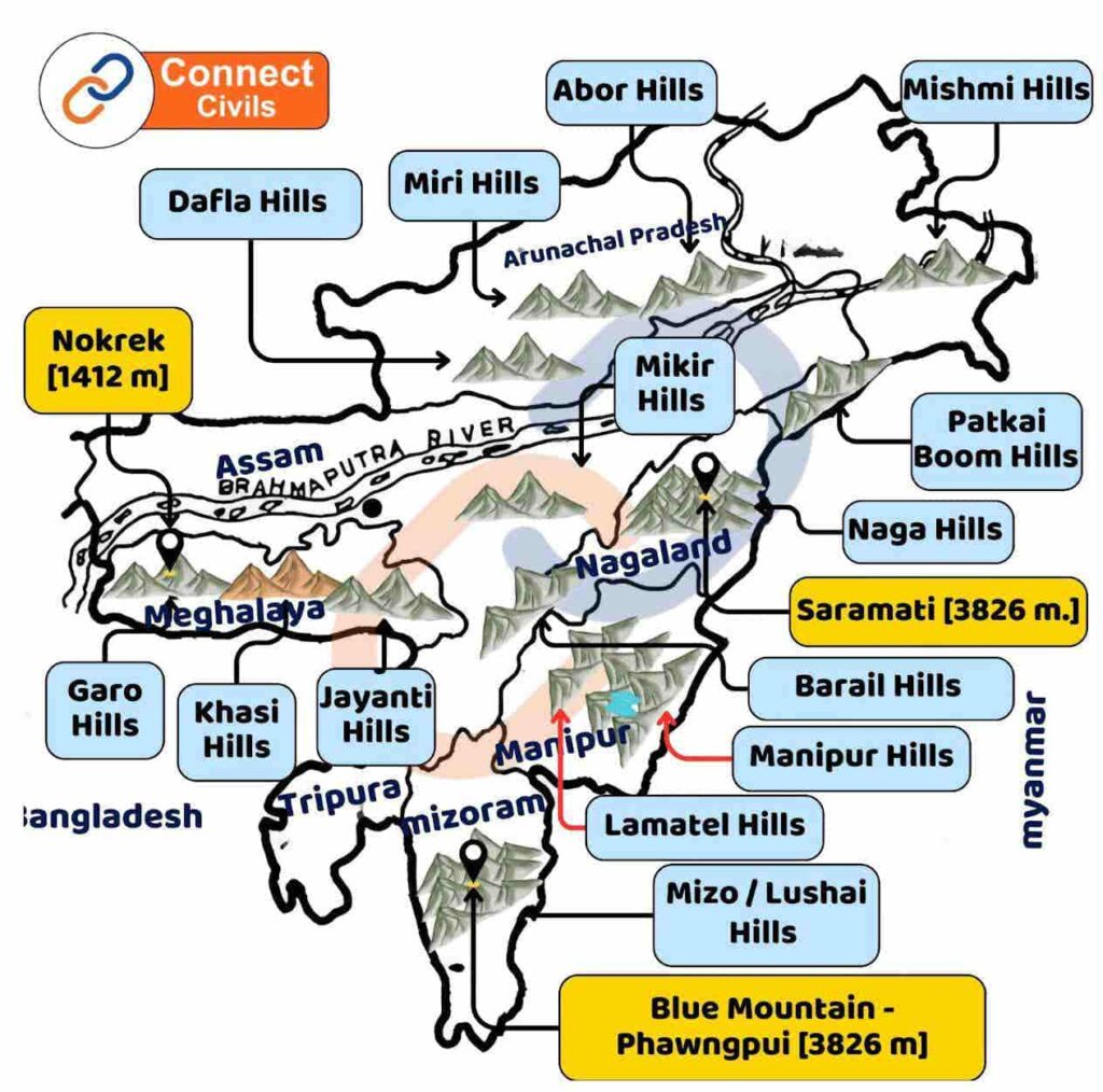
- In Arunachal Pradesh, it is combined with the middle Himalayas and is known as Dafla, Miri, Abor and Mishmi.
- In Himachal Pradesh and Punjab, temporary streams are formed in Shivalik during monsoon which are called Chos.
- These streams erode the Shivalik mountain and divide it into many parts.
- The range formed by new soft sediments is affected by landslides.
C. North-Eastern Himachal
- The hills extending from north to south in the north eastern states of India are collectively called Purvanchal.
- The hills are formed by the convergence of the Indian plate and the Burma plate.
- The Brahmaputra river defines the easternmost boundary of the Himalayas. After the Dihang Gorge, the Himalayas spread towards the south in a sharp or axisymmetric bend in the north eastern states of India.
- Extension – Patkai Bum [Arunachal Pradesh] to Mizo/Lusai Hills (Mizoram). These mountain ranges are spread from north to south on the India-Myanmar [Burma] border.
- Purvanchal mainly includes Patkai Bum (Arunachal Pradesh), Naga Hills, Manipur Hills, Mizo Hills, Tripura Hills, Barail Hills (in Assam and Nagaland), Laimatel Hills (in Manipur). These are hills made of sandstone.
- Most of the hills of the North-East Himalayas are separated by small and big rivers, where many tribes practice Jhum/Shifting Agriculture.
- The largest valley of Purvanchal Hills in the middle of Manipur Hills is Imphal Valley.
- Passes – Diphu, Hugan, Chowkan, Pangsaab, Likha Pani.
- Mizoram, also known as ‘Molasses Basin’, is made of soft and unconsolidated rocks.
- Mizo Hills are also known as Lushai Hills and its highest peak is Blue Mountain which is also known as Fangpui. Fangpui National Park is situated here.
- Highest Peak – Saramati (3,826 m) in Naga Hills.
- Loktak Lake, the largest freshwater lake of eastern India is situated here. Lamjao, the only naturally floating national park of the world is situated here.
- This region receives heavy rainfall due to monsoon winds, due to which there is rich vegetation and biodiversity here. It is one of the 36 biodiversity hot spots of the world.
Regional division
Apart from North-South, the Himalayas can be divided regionally on the basis of the boundaries of river valleys. The concept of regional division was given by ‘Sydney Burrard’.
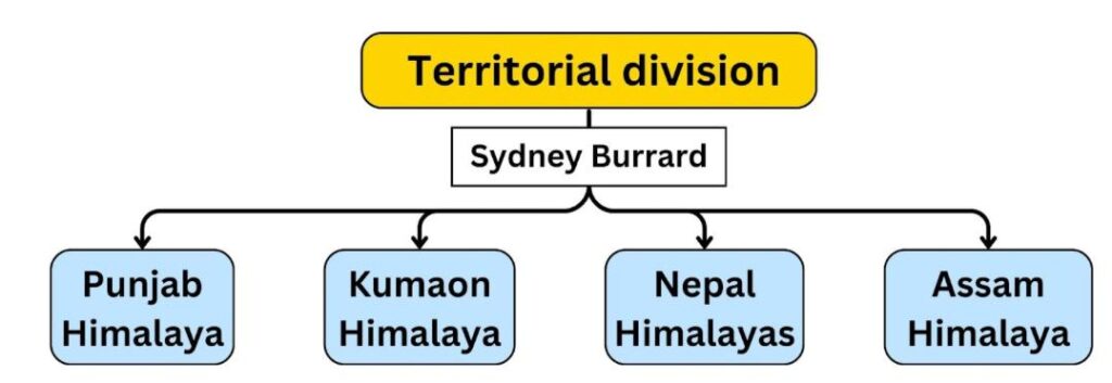
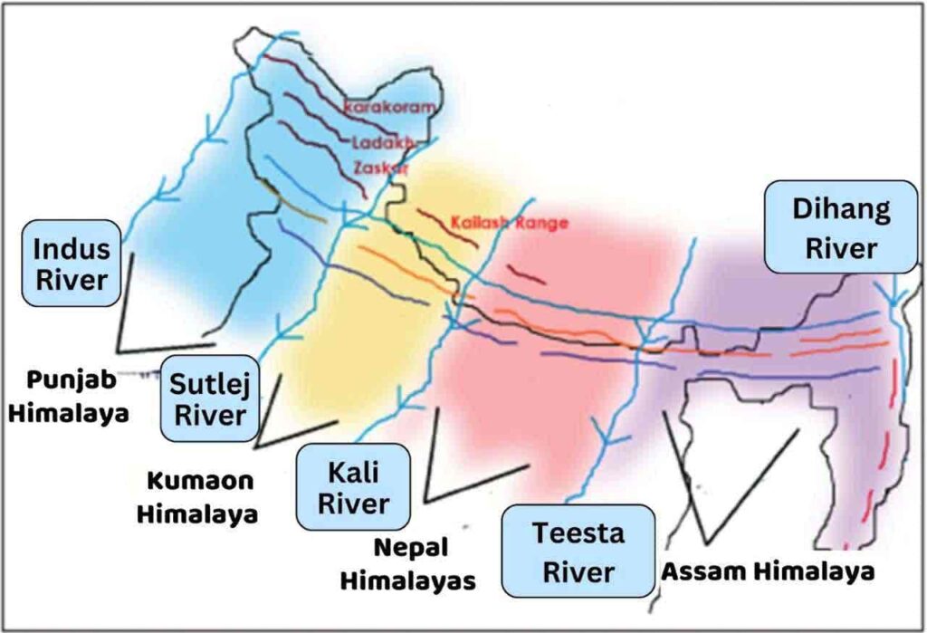
Punjab / Kashmir Himalaya
- Between Indus and Sutlej river, 560 km. (Kashmir Himalaya + Himachal Himalaya)
- Here the Himalayas gradually gain height and the width of the Himalayas is the highest here. [250-400 KM]
- Major mountain ranges of this part – Karakoram, Ladakh, Pir Panjal, Jaskar and Dhauladhar mountain ranges.
Kumaon Himalayas
- Between Sutlej and Kali River, length- 320 km.
- This part is mainly located in Uttarakhand and is higher than Kashmir Himalayas.
- (Source of Bhagirathi and Yamuna, Nanda Devi Peak (7817M) is the highest peak of this mountain range).
Nepal Himalaya
- Between Kali-Tista river, length- 800 km.
- Most of the area is in Nepal, some parts are in Tibet, Sikkim and West Bengal [Darjeeling].
- The world’s highest peaks are located in Nepal Himalayas only. (Mount Everest, Kanchenjunga, Dhaulagiri, Makalu mountain ranges).
- There is a lack of passes in this part of Himalayas due to high altitude. Nathu-la, Jelip-la in Sikkim state connect Gangtok capital to the capital of Tibet.
Assam Himalaya
- Between Teesta and Dihang-Brahmaputra river, length – 740 km.
- This part is located in Tibet, Sikkim, Bhutan, Arunachal Pradesh and partly in Assam.
- Here the height of the Himalayas starts decreasing again. The width of the Himalayas is the least here.
- Major peaks – Namcha Barwa, Kula-Kangri, Kabru, Chumalhari, Jang Sangla, Pauhuni, Naga Pahari region
- The Naga Hills act as a water divide between India and Myanmar (Burma).
Territorial division of the geomorphic section of the Himalayas
On the basis of topography, alignment of mountain ranges and other landforms, the Himalayas can be divided into the following subdivisions:
- Kashmir or North-Western Himalayas
- Himachal and Uttarakhand Himalayas
- Darjeeling and Sikkim Himalayas
- Arunachal Himalayas
- Eastern Hills and Mountains
Kashmir or North-Western Himalayas
- The major mountain ranges in this are Karakoram, Jaskar, Ladakh, Pir Panjal etc.
- Ladakh located in Kashmir Himalayas is a cold desert. It is situated between the Greater Himalayas and Karakoram ranges.
- Zojila, Banihal, Fotula, Khardug La etc. are the major passes. Dal Lake and Wular Lake are fresh water lakes in this region, while the water of Pangong and Somuriri lakes is saline.
- Indus and its tributaries- Jhelum and Chenab flow through this region. Jaskar River meets Indus River in Leh.
- Major pilgrimage sites like Vaishno Devi, Amarnath Cave and Charar-e-Sharif are located in this region.
- Longitudinal valleys are found in its southern part, which are called ‘Doon’; of which Jammu-Doon and Pathankot Doon are prominent.
Himachal and Uttarakhand Himalaya
- This part of the Himalayas is situated between the Ravi River in the west and the Kali River (a tributary of Ghaghra) in the east.
- The three main mountain ranges of the Himalayas – Greater Himalayas, Lesser Himalayas (called ‘Dhauladhar’ in Himachal Pradesh and ‘Nagtibba’ in Uttarakhand) and Shivalik ranges are located in this section.
- The two main topographies of this region are Shivalik and Doon, such as Chandigarh-Kalka Doon, Nalagarh Doon, Dehradun, Harike Doon and Kota Doon etc. Among these, ‘Dehradun’ is the largest valley.
- India’s third highest peak Nanda Devi is a part of the Kumaon Himalayas.
- People of a nomadic community called ‘Bhotiya’ live in the valleys of the Greater Himalayas, who migrate seasonally. They migrate to ‘Bugyal’ (high altitude grasslands) in summer and return to the valleys in autumn.
- Tourist centres like Shimla, Dalhousie, Dharamshala, Chamba, Kullu-Manali are located in Himachal-Himalaya.
- Famous tourist centres in Kumaon Himalaya – Mussoorie, Nainital, Ranikhet, Almora and Bageshwar.
- The famous Valley of Flowers and Gangotri, Yamunotri, Kedarnath, Badrinath and Hemkund Sahib are the main pilgrimage sites here and there are many Prayags (river confluences) in this region, of which Devprayag, Karnprayag, Vishnuprayag and Rudraprayag are the main ones.
- Artesian basin (Patal Tod wells) are found in the Terai region of Uttarakhand which are natural water sources that appear automatically from the surface.
Darjeeling and Sikkim Himalaya
- It is situated between the Nepal Himalayas in the west and the Bhutan Himalayas in the east. This region is famous for high peaks like Kanchenjunga, deep valleys and fast flowing rivers.
- A tribe called ‘Lepcha’ lives in the northern high part of this mountainous region, while a mixture of Nepalese, Bengali and Central Indian tribes is found in the lower southern part (especially Darjeeling Himalayas).
- There are no Shivalik hills here, but in their place ‘Duare’ topography is found, which is used for tea gardens.
Arunachal Himalaya
- This region extends from the Bhutan Himalayas in the west to the Diphu Pass in the east. Namcha Barwa and Kangto are its two major peaks.
- Many tribes live in this region, the major ones among them being Monpa, Dafla, Abor, Mishmi, Nishi and Naga.
- Most of the tribes practice Jhum agriculture, also known as shifting or slash and burn agriculture.
5.
Eastern Hills and Mountains
- These are hills and mountains situated in the far east of the Himalayas, south of Arunachal Himalayas, whose direction is from north to south.
- In the north, these are known as Patkai Bum, Naga Hills, Manipur Hills and in the south as Mizo and Lushai Hills.
- The tribes living in the hilly areas here practice Jhum or shifting agriculture.
- The Barak River flowing here is the main river of Manipur and Mizoram.
- ‘Loktak Lake’ is situated in the middle of the Manipur valley and it is surrounded by hills on all sides.
- Mizoram, which is also called ‘Molasses Basin’, is made up of soft and unconsolidated rocks.
Difference between Western and Eastern Himalayas
| Western Himalaya | Eastern Himalayas |
| Extending from Indus to the western part of Kali River. | From east of Singalila Mountain in Sikkim to the eastern limit of the Himalayas. |
| The Western Himalayan region receives more rainfall from westerly disturbances (in winter). | The eastern Himalayan region receives more rainfall from the southwest monsoon (in summer) |
| The amount of precipitation is about one-fourth or much less than that of the Eastern Himalayan region (average rainfall 100 cm or less). | The Eastern Himalayas receive about four times more rainfall than the Western Himalayas. Dense forests have developed here due to high rainfall (average rainfall is 200 cm or more). |
| Biodiversity diversity is comparatively low. | The area is famous for its biodiversity and biodiversity hotspots are also located here. |
| The lower limit of permanent snow cover and the height of the tree line are lower than that of the Eastern Himalayas. | The height of the lower limit of the snow line and the tree line is higher than that of the Western Himalayas. |
| The rivers Ganga, Yamuna and Indus flow in this region. | The major rivers of the Eastern Himalayan region are Teesta, Brahmaputra. |
| This includes ranges like Karakoram, Dhauldhar, Jaskar, Kailash, Pir Panjal etc. | The Eastern Himalayan region includes Patkai Bum, Naga Hills and high peaks like Kanchenjunga, Namcha Barwa. |
Importance of Himalayas
Great poet Kalidasa has described Himalaya as the king of mountains and the abode of gods.
- The Himalayas provide a natural boundary in the north and east, providing traditional security.
- They ensure seasonal stability and defence by blocking the cold polar winds from the north, and also prevent the monsoon winds from moving northwards beyond the Himalayas.
- The water from melting snow gives rise to perennial rivers, which are important for irrigation and hydroelectricity.
- The fertile alluvial soil brought by these rivers forms vast, flat and fertile plains, which are of great economic importance.
- Due to the diverse climate, there are many forests, medicines, fruits, wood and herbs available here, and there is also a rich variety of wildlife.
- There are opportunities for cultivation of saffron, tea, potatoes, fruits and animal husbandry on the hill slopes.
- Due to the structure of the Himalayas, there are possibilities of mineral oil from various mineral deposits and oil shales.
- Natural lakes, picturesque places and famous tourist centers (such as Shimla, Mussoorie, Nainital) increase the tourism importance of the Himalayas.
- From the mythological point of view, the abode of the gods, major pilgrimage sites (Badrinath, Kedarnath, Kailash etc.) and suitability for mountaineering show the spiritual and adventurous importance of the Himalayas.
