In World Geography, mountains are towering landforms that rise prominently above their surroundings, shaped by tectonic forces and erosion over millions of years. These majestic features influence climate, biodiversity, and human cultures across the globe.
Previous Year Question
| Year | Question | Marks |
| 2016 S. E. | Briefly explain the location, name and importance of the Great Lakes of North America. | 5 M |
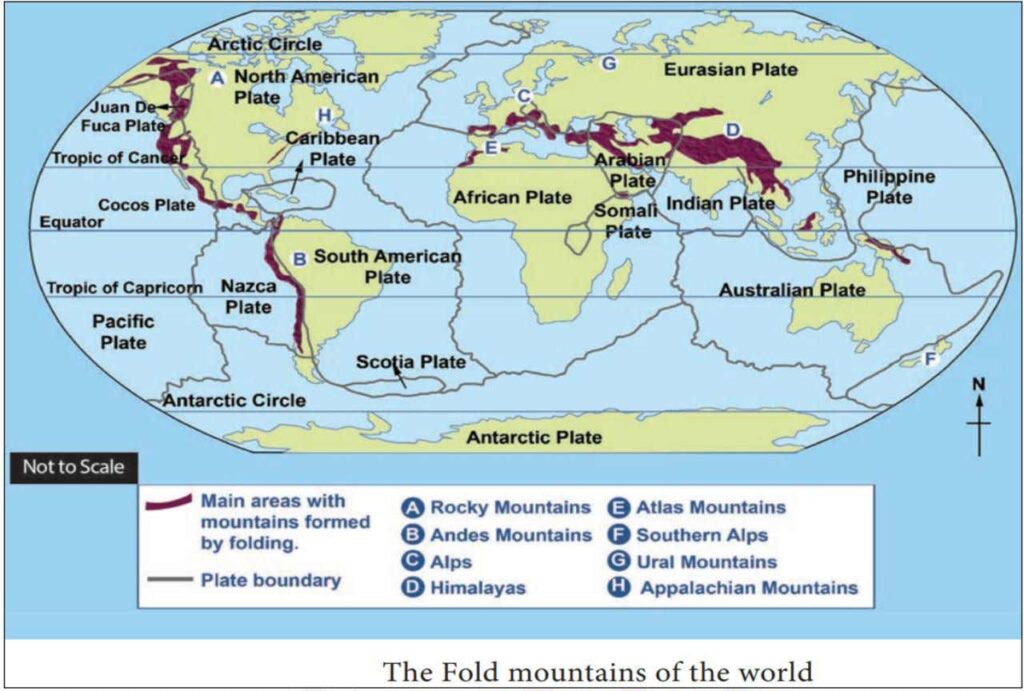
| 2016 | What are ‘fold mountains’? Give some examples of folded mountains along with their location. | 5 M |
| 2018 | Name four mountain building events in the world and their main mountains. | 2 M |
| 2021 | Briefly describe the geographical features of the Rocky Mountain range. | 5 M |
| 2024 | Name the highest mountain peaks of the following continents: निम्नलिखित महाद्वीपों के सर्वोच्च पर्वत शिखरों के नाम बताइये : (A) North America – उत्तरी अमेरिका (B) South America – दक्षिणी अमेरिका (C) Africa – अफ्रीका (D) Australia – ऑस्ट्रेलिया | 2 M |
- Mountains come under the secondary category of relief features on the earth which are formed by the internal forces of the earth, they are called constructive forces.
- The topographic features which are very high [minimum 500 meters high] from the surrounding surface, whose peak is narrow and slope is steep, are called mountains.
- According to Finch, “Mountains are 600 meters or more above sea level and have a slope of 260 degrees to 350 degrees.
- The height of mountains is more than 700 meters above sea level and the landforms whose height is 300 to 700 meters are called hills. Mountains are the short form of mountains. The highest peak of a mountain or hill is called a peak.
Different Forms of Mountains
Mountain Ridge
- Long, narrow and high mountains are called mountain ridges.
Mountain Range
- The sequence of mountains and hills is called a mountain range, which includes many ridges, peaks and valleys.
- They are formed in the same period and by the same process and their spread is in the form of a line in a straight narrow strip. For example – three ranges of Himalaya mountain.
Mountain Range
- When long and narrow mountains formed in different eras are found in parallel extension, then it is called a mountain range or mountain range, for example – Appalachian mountain range.
Mountain System
- A group of different mountain ranges formed in the same era is called a mountain system or mountain system.
Mountain Group
- When the ridges and ranges of a region are extended like a mountain range but are not extended in a straight line like a garland but are spread in an unsystematic manner, then they are called mountain groups or mountain communities.
Cordillera
- A group of mountain ranges or mountain systems is called a mountain group. It consists of mountain ranges, mountain systems and mountain chains formed in different ways in different eras. Example – Western Cordillera of North America.
Types and classification of mountains
Mountains are classified into many forms based on their age, location, structure, texture, etc.
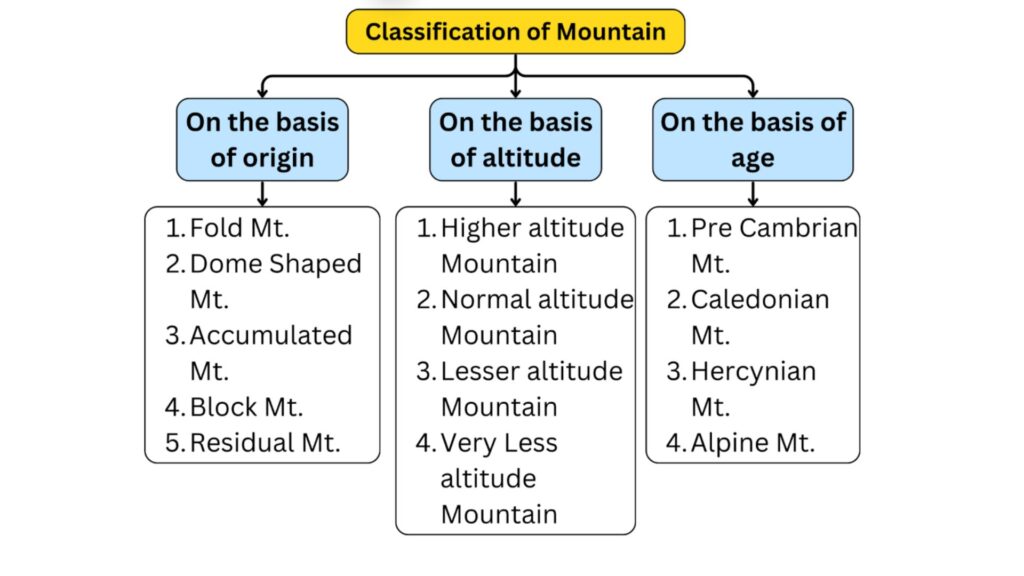
A. Classification of mountains based on their origin
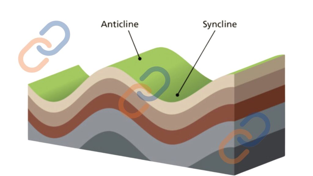
1. Fold Mountain –
- These mountains are formed when the surface rocks are folded or bent due to the compressional force generated inside the earth.
- The part which is bent due to the compressional force is called anticline and the part which sinks down is called syncline.
- Rapid geological movements raise the folds of these synclines and anticlines and over time the folded mountains are raised.
- Folded mountains are arc-like in shape and fossils of organisms living in shallow seas are found in their rocks because many folded mountains are also formed by lateral compression force in the sedimentary rocks of geosyncline.
- They are mainly made up of sedimentary rocks but huge granite intrusions are found in the direction of the length of these mountains
- These are the newest mountains in the world and fossils are not found in their rocks.
| Continent | Fold Mountains |
| Asia | Himalaya, Arakan Yoma, Sulaiman, Hindukush, Zagros, Alborz, Pontic, Torus, Karakoram, Kulun |
| Europe | Caucasus, Balkans, Carpathians, Alps, Dinaric, Apennines, Pyrenees, Cantabrian |
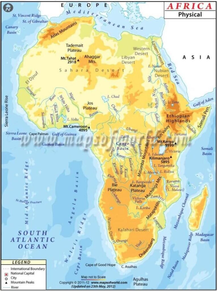
| Africa | Atlas |
| North America | Rockies |
| South America | Andes |
| Australia | The Great Dividing Range is a very old folded mountain range |
Characteristics of Fold Mountains –
Not all fold mountains are the same, but they have some common features –
- Folded mountains are the newest mountains, in which the world’s highest peaks are found. For example – Mount Everest of the Himalayan mountain range
- They are formed due to pressure on sedimentary rocks and these sedimentary rocks are deposited from the deposits brought by rivers.
- The rocks of folded mountains were deposited in marine or aquatic areas. Remains of marine organisms are found in its rocks.
- Folded mountains are long and wide.
- Folded mountains are formed from geosynclines, hence geosyncline is called the cradle of folded mountains.
- Due to excessive erosion, there is a disturbance in the topography of these mountains.
- The shape of folded mountains is like an arc whose slopes are convex and concave respectively. For example, the shape of the Himalayas is like a sword whose northern part is concave and the southern part is convex.
2. Dome Shaped Mountain
- The hot magma boiling inside the earth tries its best to reach the surface. When this magma is unable to come out, the surface rocks rise in a dome-shaped form.
- The Henry and Uinta mountains in the Utah state of North America are similar mountains.
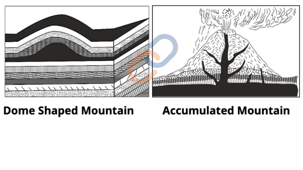
3. Accumulated Mountain
- These mountains are formed by the deposited material and debris collected in the form of large piles by wind, rivers, glaciers, waves and volcanoes.
- Fujiyama of Japan, Vesuvius of Italy and Kilimanjaro of Africa are volcanic mountains.
4. Faulted or Block mountains
- When the middle part of two parallel cracks rises upwards or the parts on both sides of the middle part sink down, then a block mountain is formed. As they are formed by faults, they are also called fault-raised mountains. Or they are called fault ledges.
- Both sides of a fault mountain usually form steep slopes, which are called fault uprights.
- Black Forest of Germany, Satpura Mountains of India, Vosges Mountains (on the France-Germany border), Wasachah Range in Utah, USA, Salt Range of Pakistan, Sierra Nevada of California, etc. are examples of fault mountains.
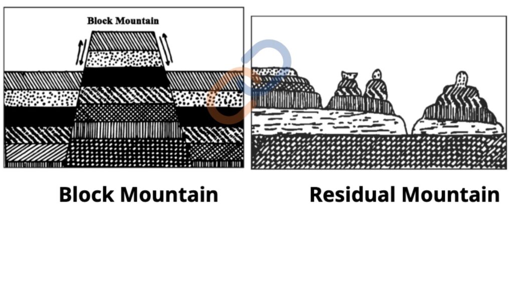
5. Residual Mountain
- If the hard rocky terrain remains elevated above the surrounding area, untouched by the erosive effect of denudation factors such as river, wind, wave, glacier etc., then it is called waste mountain.
- When the river cuts the plateau terrain and turns it into a plain, but the intermediate hard rock region is not eroded, then it takes the form of a residual mountain.
- Aravalli, Satpura, Western Ghats in India, Monadnock of America.
B. Classification of mountains according to height
Prof. Finch has presented this division –
- Higher altitude Mountain – Mountains more than 6000 feet or 2000 metres high.
- Normal altitude Mountain – These mountains are generally 4500 to 6000 feet or 1500 to 2000 metres high.
- Lesser altitude Mountain – Height between 3000-4500 feet or 1000 to 1500 metres.
- Very Less altitude Mountain – These mountains are generally 2000-3000 feet or 700 to 1000 metres high.
C. Classification of mountains on the basis of mountain building events (On the basis of age)
1. Mountains of the Pre-Cambrian period
- The oldest mountains formed approximately 4 billion to 570 million years ago.
- Formed primarily from metamorphic rocks, but due to continuous erosion and weathering, they exist only partially today.
- Examples include: Aravalli Hills in India, Laurentian Mountains, Algoman Mountains, and Caledonian Mountains in North America, Fenno-Scandian Mountains in Europe, Northwestern Highlands of Scotland
2. Caledonian Mountains –
- These mountains were formed during the Silurian and Devonian periods of the Paleozoic era, approximately 500 to 360 million years ago.
- Named after the Caledonia region of Scotland, these mountains are called “Caledonian Fold Mountains.”
- Examples include: Patagonia in South America, Appalachian Mountains in North America, Mountains of Scotland and Ireland (Sperrin Mountains) in Europe , Vindhya, Mahadeo, and Satpura ranges in India , Brazilian Highlands (Brasilides) in South America
3. Hercynian Mountains –
- These mountains were formed during the Late Paleozoic era, specifically during the Carboniferous and Permian periods, approximately 280 to 240 million years ago.
- Tectonic movements occurring around 220 million years ago are also known as Altai, Variscan, and Armorican orogenies.
- Named after the Harz Mountains in Germany, they are also called “Hercynian Mountains.”
- Examples include: Appalachian Mountains in North America Brittany Mountains, Vosges, Black Forest, Bohemian Massif in Europe Armorican and Central Massif in France Neuwald Mountains in Southern Wales Altai, Tien Shan, Nanshan, Khangan, Sayan, and Gobi Mountains in Asia Eastern Cordillera in Australia, Pennines in Europe
4. Alpine Mountains –
- They were formed in the Cenozoic era i.e. Tertiary period, around 6.5 crore years ago.
- Alpine mountains are also called Tertiary mountains.
- It has been named after the Alps of Europe.
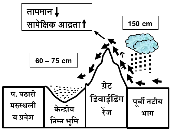
- Rocky mountains of North America, Andes mountains of South America, Balkan, Pyrenees, Apennines etc. in the Alpine mountain range of Europe, Atlas mountains of Africa, Himalayas of Asia and Elburj, Kunlun, Karakoram etc. of the Pamir knot, Arakanyoma of Myanmar are its major examples.
Theories of mountain formation
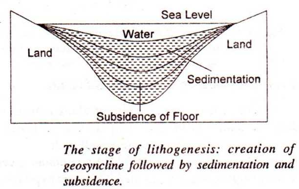
A. Kobar’s theory of Geosyncline –
- Kober presented his theory in 1923.
- This theory is based on the contraction force due to cooling of the earth.
- Kober attempted to explain the origin of mountains, their geological history, evolution and process of deformation through his geosynclinal theory.
- The main objective was to establish a relationship between ancient landmasses and geosynclines.
- Geosynclines are narrow, long and shallow water units formed between two hard landmasses. Kober called the hard landmasses on the sides of geosynclines as Kratogen or front country.
- According to Kober, the process of mountain building takes place in three major stages:
- Lithogenesis:
- The cratogens (foreground) on both sides of the syncline are constantly subjected to erosion.
- The material produced by erosion gets deposited in the depressed part of the syncline.
- Due to the process of sedimentation, the depth of the geosyncline increases and its bottom gradually becomes a victim of subsidence.
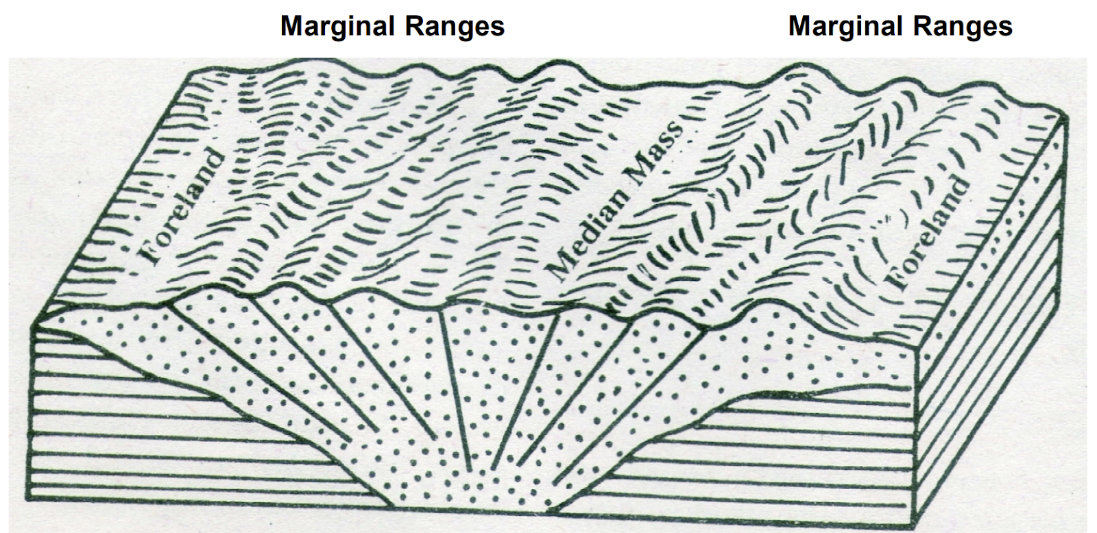
- Orogenesis
- The frontal land masses move towards each other due to contraction caused by cooling of the earth and the pressure of the sedimentary deposits.
- This horizontal compression leads to folding of the sediments accumulated in the geosyncline.
- If the compression force is normal or moderate –
- Folding occurs only at the edges.
- The central part of the geosyncline remains unaffected.
- This central part was called the “Zwischengebirge / Median Mass” by Kober.
- If the compression force is strong, the folds become more complex and large mountain ranges are formed. Kober called these mountain ranges Randketten.
- The greater the compression force, the more complex the mountain formation becomes
- Gliptogenesis:
- After mountains gradually rise, they are subjected to exogenous denudation and erosion forces.
- Continuous weathering and erosion gradually reduce the height of mountains.
Note- Regarding the formation of Himalayas, Kober said that Angaraland was situated in the north of Tethys Sea and Gondwanaland in the south as the front country. Thus, in the Eocene period, both front countries came close to each other due to which folding took place due to the generation of compression force in the deposits on both sides of Tethys Sea. This led to the formation of Kunlun Mountains in the north and Himalayas in the south and the Tibetan plateau remained as the central mass.

B. Jeffreys’ thermal contraction theory –
- In 1929, Jeffreys propounded his theory which is based on the contraction of the earth.
- Jeffreys said that the earth is cooling down and shrinking since the beginning. According to this, the process of cooling down of the earth is happening layer by layer. First, the upper layer cools down and after its cooling limit, the layer below it cools down.
- Due to cooling, the upper layer shrinks, reducing the Earth’s volume.
- As the deeper layers start contracting, the upper layer remains larger than the lower one.
- Jeffreys identified a level between these layers where no significant tension or compression occurs, calling it the “stress-free plane”.
- Jeffries said that the process of mountain building is not continuous, it happens at some specific time. The accumulated stress and pressure from contraction build up over time.
- Once this stress exceeds the strength of the crustal rocks, folding begins, leading to mountain formation.
C. Convection current theory of Arthur Holmes
- Presented in 1928 – 29.
- This theory was given to explain the origin of major terrestrial forms (Relief Features) on the surface of the earth.
- Convection is the process in which heat transfer occurs through the movement of particles in a medium (liquid or gas).
- According to Holmes, the driving force of mountain formation is derived from the convection currents generated within the earth.
Types of convection currents:
1. Rising Columns Convection Current:
- These currents pull the crust and cause divergence.
2. Falling Columns:
- These currents cause compression of the crust.
- According to Holmes’ Convection Current Theory, the radioactive elements present in the Earth’s interior (Uranium, Thorium, and Potassium) play a crucial role. These elements decay spontaneously, generating heat, which accumulates over time, leading to a rise in temperature. As a result:
- Convection currents are generated in the Earth’s mantle, moving upward.
- When these currents move in opposite directions, they create tensional forces in the lithosphere, causing cracks or rifts.
- However, when two convection currents meet under a continental margin, they sink downward, exerting compressional forces on the continental edges.
- This compression leads to the formation of geosynclines, which ultimately results in the formation of folded mountains.
- The convection currents operate cyclically, completing their process in three stages.
- First Stage– Rising convection currents flow beneath continental regions, creating geosynclines (deep depressions).Sediments accumulate in these geosynclines over time. Due to high temperature and pressure, the sediments undergo metamorphism, increasing their density and causing them to sink further.
- Second Stage– The movement of convection currents intensifies. Continental and oceanic currents collide, forcing the denser oceanic crust to subduct. This exerts horizontal compressional forces on the geosyncline deposits, causing folding and uplift, leading to mountain formation.
- Third Stage – The speed of convection currents decreases. This occurs due to the exhaustion of hot material in rising columns and the cooling of descending material. Eventually, convection currents stop, and the mountain slowly stabilizes, achieving isostatic balance over time.

D. Joly’s radioactivity theory
- Joly propounded the radioactive theory in 1925 in his book “The surface History of the Earth”. Joly’s theory is also known as “Thermal cycle theory” and “History of the Earth’s surface”.
- Joly stated that the continent is made up of light sial and the ocean floor is made up of heavy boundary material, whose density is 2.67 and 3.0 respectively. Thus the crust is made up of sial and substratum boundary and the low density sial is based on the high density boundary.
- Radioactive elements such as uranium and thorium present in the rocks of the earth disintegrate and generate heat, which is found more in the continental regions.
- According to Joly, more heat escapes from the earth’s crust than the heat generated by radioactive substances in the sial (upper part) because heat cannot be stored. Joly said that the temperature in the lower part of the sial layer is 1050° Celsius. Heat cannot be conducted from the boundary to the sial, on this basis the temperature of the upper part of the substratum should also be 1050° Celsius. But different conditions are found under the oceans, there is no sial there and the heat generated in the boundary gets mixed with the sea water through conduction. But this does not happen at greater depths. The melting point of basalt is 1150° Celsius, which is 100° Celsius higher than the estimated temperature of the upper part of the boundary. Hence, when the temperature of the substrate (boundary) becomes 1050°C to 1150°C due to radioactive substances, then it reaches the melting stage.
- It takes 33 to 56 million years for the temperature to increase by 100°C due to radioactive substances.
During this period, when the substratum melts, the following conditions arise in the structure of the Earth –
- Period of sea transgression:
- Melting of the SiMa increases its volume, due to which the diameter of the earth increases and the continents start rising. Melting of the sima(substratum) will decrease its density and due to sinking of the lighter sial part, ocean water encroaches on the shores and sediments get deposited in the land tectonic zone.
- Cracks are formed in the ocean floor, due to which oceanic islands are formed.
- Oceanic Retreat Period:
- After the substratum melts, the continents start floating and move in the west direction due to the tidal force. When the temperature cools down, the substratum solidifies and contracts. The shrinking of the ocean floor exerts pressure on the continental edges, which leads to the formation of mountains by folding. The mountains rise due to the vertical movement of the substratum while solidifying.
- According to Joly, this process takes place in 33 to 56 million years, in which the shape of the continents and oceans keeps changing.
E. Daly’s continental drift theory
- Daly propounded this theory in his book Our Mobile Earth in 1926. Daly’s theory is based on the force of gravity.
- According to Daly’s theory, the primitive crust of the Earth formed with equatorial and polar domes. Between these domes, water bodies existed, referred to as the Proto-Pacific Ocean (Panthalassa) and mid-latitude furrows.
- Erosion caused sediments from the domes to accumulate in the mid-latitude troughs, leading to subsidence of the ocean floor and the creation of lateral pressure.
- This pressure led to the expansion of the domes, causing them to weaken and fracture. The fractured crustal blocks began shifting towards the troughs.
- Due to these processes, folding of sediments in geosynclines occurred, leading to the formation of mountains.
- According to Daly’s theory, the greater the continental compression, the higher and more extensive the mountains will be.
F. Plate tectonics
- Exponents – Mackenzie, Parker and Morgan in 1967.
- Plates-
- A plate (lithospheric plate) is a large, irregularly shaped block of solid rock composed of continental and oceanic lithospheres.
- The word plate was first used by Tujo Wilson for the outer layer of the Earth. This layer is a combined unit of the crust and upper mantle which is known as the ‘lithosphere’. Its thickness is 5 to 100 km in the oceans and about 200 km in the continental regions.
- The theory of plate tectonics proposes that the earth’s lithosphere is divided into seven major and some minor plates which continuously move with respect to each other on the asthenosphere and converge, diverge and rub against each other, causing tectonic activities like earthquakes, volcanoes and trough generation. This entire movement of plates is called plate tectonics.
Major Plates–
Scholars are not unanimous about the number of plates, however Morgan has divided the entire lithosphere into 6 large and 20 small plates. Major large plates
1. Indo-Australian Plate –
- It includes the terrestrial crust of the Indian subcontinent and Australia, and the south-western oceanic crust of the Indian Ocean and the Pacific Ocean.
2. Eurasian Plate-
- Mostly made up of continental crust. This plate extends from the Mid-Atlantic Ridge in the west to the Alps-Himalayan mountain range in the south and the island arcs in the east.
3. African Plate
- It is a mixed continental and oceanic plate. Its extension is up to the Indian plate in the east, Antarctica in the south, Mid-Atlantic Ridge in the west and the Eurasian plate in the north.
4. North American Plate
- The western Atlantic floor is included, and the South American plate and the Caribbean islands determine its boundaries.
5. South American Plate
- The western Atlantic floor is contained within and separated by the North American Plate and the Caribbean Islands.
6.Pacific Plate
- Extending westward from the East Pacific Rise across the entire Pacific Ocean, it is the only plate composed entirely of oceanic crust.
7. Antarctica Plate
- Most of its area is covered with ice. This plate extends up to the mid-ocean ridges around the Antarctic continent.
Some important small plates are as follows:
- Cocoas Plate – Located between the Central American and Pacific Ocean plates.
- Nazca plate Located between the South American and Pacific Ocean plates.
- Arabian plate -The land area of the Arabian Peninsula is included.
- Philippine plate – Located between the Asian continent and the Pacific Ocean plate.
- Caroline plate- These plates have been moving on the globe between the Philippine and Indian plates, north of New Guinea, throughout the history of the earth.
Wegener’s concept that only continents are moving is not correct. Continents are part of a plate and plates are moving. It is an undisputed fact that all plates have been moving in geological history and will continue to move in the future.
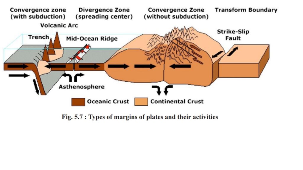
Three types of plate boundaries are formed as a result of plate movement –
1. Divergent boundaries –
- When two plates move away from each other in opposite directions, they are called divergent plates. The place where the plates move away from each other is also called the diverging site. This is an area where magma constantly rises upwards, which leads to the formation of new oceanic crust. Hence, these are called constructive margins.
- Example – Mid-Atlantic Ridge [Here the American plates (North American and South American plates) and the Eurasian and African plates are separating.]
2. Convergent boundaries
- When two plates move towards each other and where two plates collide, their edges are called destructive edges.
- The place where the plates sink is also called the subduction zone.
- Due to the convergence of two tectonic plates, one plate overrides the other, while the heavier plate subducts beneath it. The subducted plate’s leading edge breaks and melts as it enters the mantle. This molten material resurfaces through weak spots in the crust, leading to the formation of volcanoes and island arcs. The island and volcanic chain is spread on the edges of the Pacific Ocean plate.
- The convergence of plates is of the following three types–
- Continent-continent convergence of plates – The plate with higher density subducts under the plate with lower density. As the continental plate comes closer, the ocean situated between them disappears.For example – formation of Himalayas – In the Eocene era, there was a huge Tethys Sea. To its north was the Eurasian plate and to its south was the African-Indian plate. The Indian plate moved towards the Eurasian plate and due to convergence, the Indian plate got subducted under the Eurasian plate. Due to which the size of the Tethys Sea decreased and the Himalayas were formed 20-30 million years ago.
- Convergence of continent-ocean plates– The oceanic plate with higher density gets subducted under the continental plate with lower density. This generates lateral compressional force and due to this force, the deposits deposited on the edge of the continental coast get folded and folded mountains are formed. The Rocky Mountains on the North American coast and the Andes Mountains on the South American coast have been formed due to the convergence of the Pacific Oceanic plate and the American plate.
- Convergence of ocean-ocean plates – The plate with higher density gets subducted under the plate with lower density. This generates compression force and leads to the formation of island arcs and island arcs. The arc of Philippines and the north-eastern islands of the Indian Ocean are examples of arches and island arcs.
3. Transform boundaries
- These boundaries are formed where two plates slide parallel to each other. In this situation, no new surface is formed nor destroyed. Hence it is called conservative margin
- Due to the sudden sliding of the plates, severe earthquakes occur in this area.
- In the western part of North America, there is a protective edge of two sub-plates along the San Andreas fault.
Reason of the motion of the plates –
- The geothermal energy generated by radioactive decay within the Earth rises as convective currents, causing movement in tectonic plates.
- Convective currents directly beneath tectonic plates drive their horizontal motion.
- Key convection-driven activities include:
- Upwelling of magma at mid-oceanic ridges.
- Subduction of plates at convergent boundaries, where plates sink into the mantle.
Importance of mountains on human life
- Storehouse of natural resources: Forestry and Timber: Mountain forests provide timber, lac, resin, medicinal herbs, and raw materials for the paper industry. Slopes support agriculture, particularly tea and fruit cultivation. The Appalachian Mountains (USA) are known for coal and limestone deposits.
- Hydroelectricity generation: Waterfalls and rapids from mountain rivers facilitate hydroelectric power generation.
- Source of water: Glacier-fed perennial rivers supply drinking water, irrigation, and fisheries.
- Creation of fertile plains: Rivers create fertile plains by carrying away soil from upper regions, like the Ganga-Brahmaputra plain.
- Political boundaries: Mountains form political boundaries between two countries and to some extent protect them from mutual attacks. Mountains like the Himalayas form natural and political boundaries between India and China.
- Effect on climate – Mountains have lower temperatures due to altitude. They act as climatic barriers, influencing weather patterns. Example: The Himalayas block cold winds from Central Asia, affecting India’s climate.
- Tourist Destinations: Mountains develop as tourist centers due to their natural beauty and salubrious environment.
- Religious Importance: Pilgrimage sites and spiritual centers are located on the mountains, such as Badrinath and Vaishno Devi.
Mountains of the world
Asia Mountains
|
Mountain |
Characteristics |
|
|
|
|
Hindu Kush Mountains |
|
|
|
|
|
Chagai Hills |
|
|
Arakan Yoma Mountain Range |
Note- Pegu Yoma (Myanmar) – area known for mineral oil. [also non-ferrous metallic minerals] |
|
Hakakabo Razi |
|
|
Pamir Mountains |
|
|
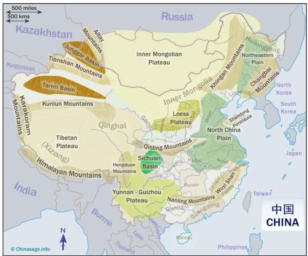
Great Khingan, Kunlun Shan Mountains – |
located in China. |
|
Wuyi Shan, Nanling, Rayu mountain ranges |
south-east of China. |
|
Tian shan mountain range |
|
|
Altai Mountains |
 |
|
Ural Mountains |
|
|
Caucasus Mountains |
|
|
Sayan Mountains |
|
|
Punchak Jaya (Carstensz Pyramid) |
|
|
Barisan Mountains |
|
|
Mount Kinabalu |
|
|
Annam Mountains |
|
|
Japanese alps |
|
|
Mount Fuji |
|
|
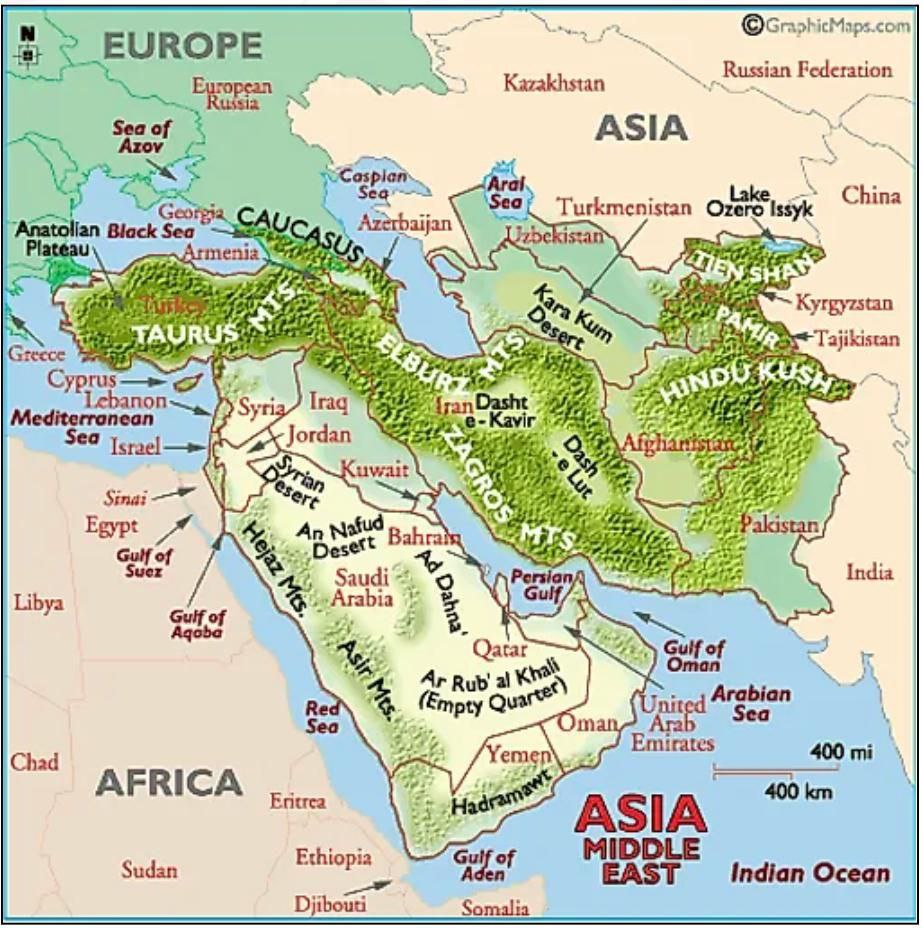
Elburz mountain range |
|
|
Zagros Mountain Range |
|
|
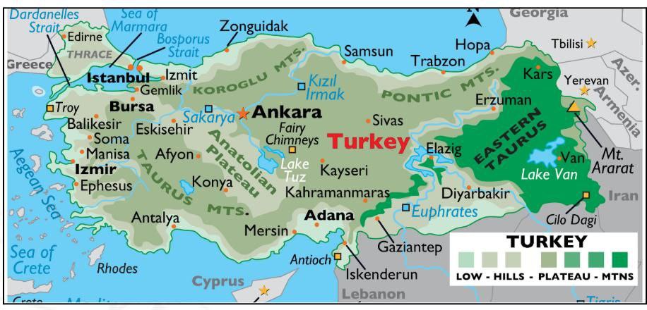
Koroghlu, Pontic and Taurus mountain ranges |
|
|
Mount Ararat |
 |
|
Asir Mountain Range |
 |
|
Hadramawt |
yemen |
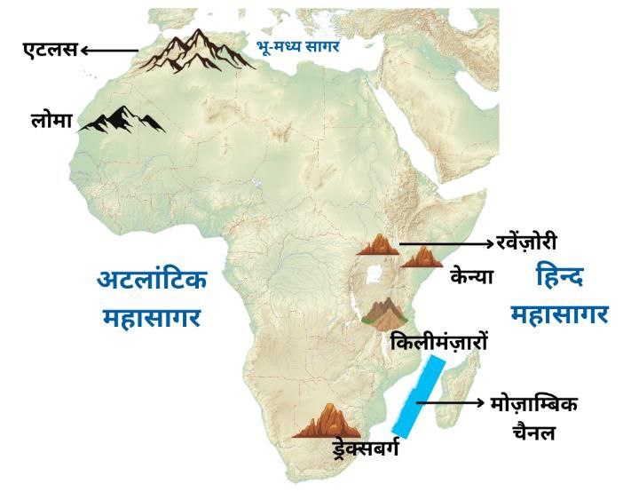
Africa Mountains
|
Mountain |
Characteristics |
|
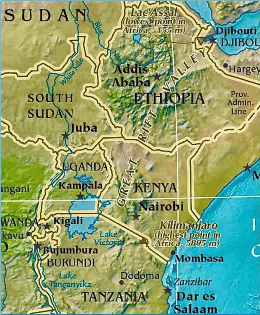
Great Rift Valley |
 |
|
Mount Kilimanjaro |
 |
|
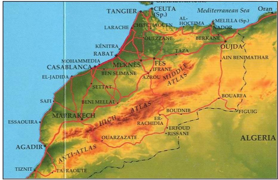
Atlas Mountain |
 |
|
Loma Mountain |
 |
|
Drakens berg Mountains |
|
|
Ruwenzori Mountains |
|
|
Kenya Mountain |
|
|
Tibesti Mountains |
|
|
Nuba Mountain |
|
|
Mount cameron |
|
|
Katanga Mountains |
|
|
Mount Sinai |
|
|
Mount Elgan |
|
|
Muchinga Mountain |
Located on the border of Tanzania and Malawi. |
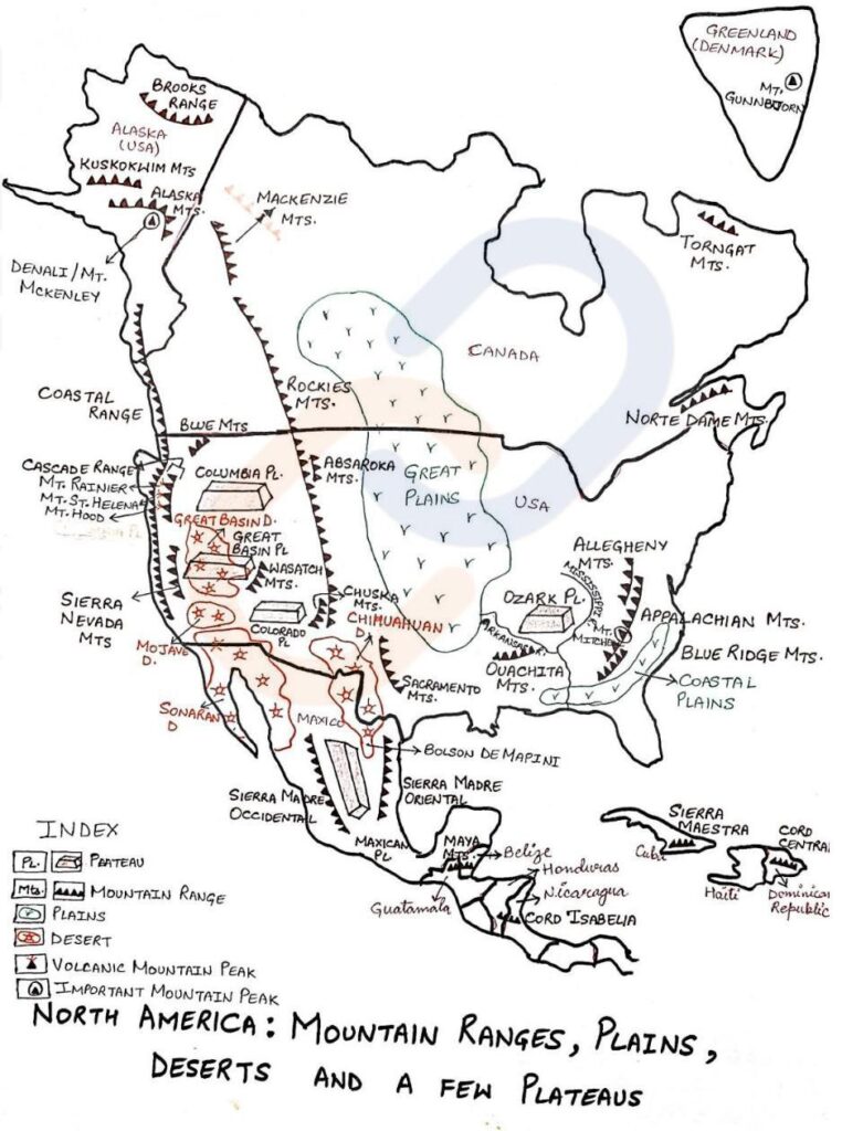
North America Mountains
|
Mountain |
Characteristics |
|
Western Cordillera |
|
|
Appalachian Mountains |
 |
|
Mackenzie Mountain Range |
|
|
Mauna Kea Volcanic Mountain |
|
|
Other mountain |
|
South America Mountains
|
Mountain |
Characteristics |
|
Andes Mountain |
Note – Cordillera Central (Central Range) – in Colombia The Magdalena River drains between the Cordillera Oriental and the Cordillera Central [Colombia’s lifeline]
|
|
|
|
|
brazilian mountains |
|
|
Toomuc – Hoomuc Mountains |
|
Europe Mountains
|
Mountain |
Characteristics |
|
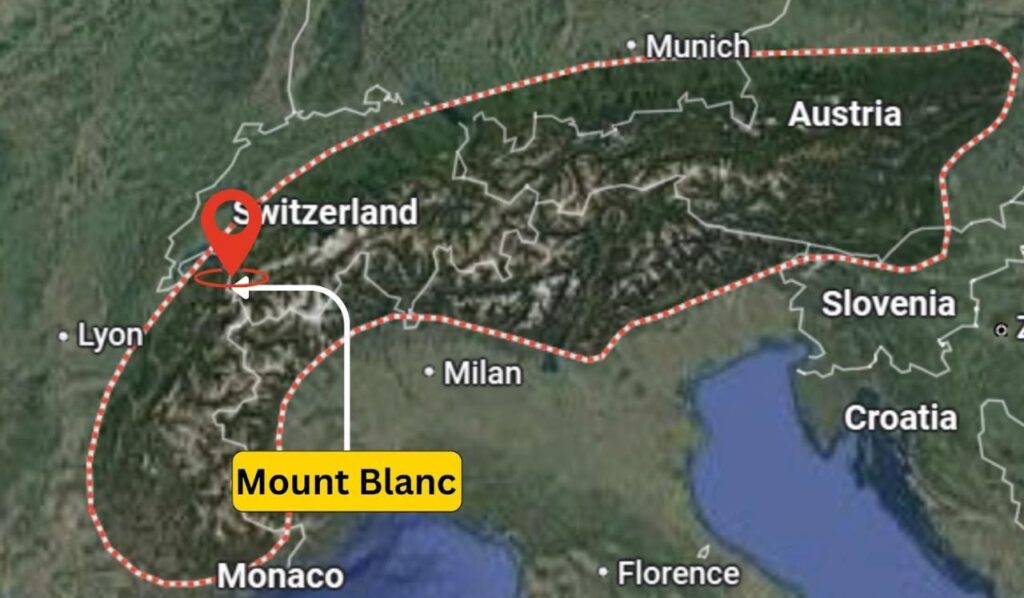
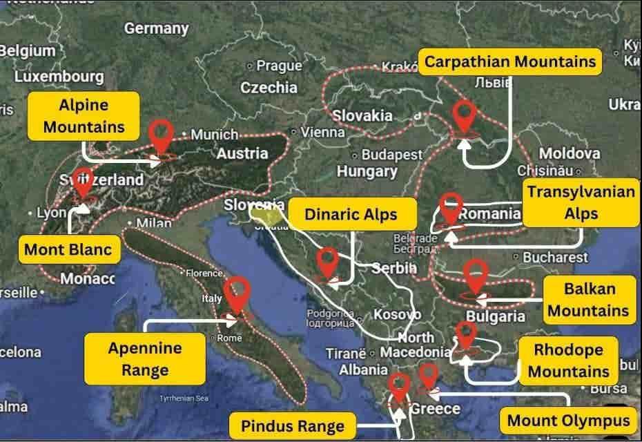
Alps mountain range |
 |
|
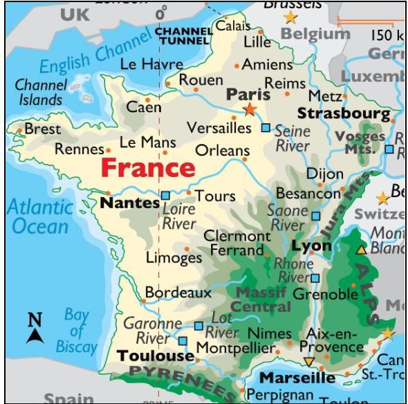
Jura Mountains |
|
|
Pyrenees mountain |
|
|
Vosges mountain |
 |
|
Black Forest mountain |
|
|
Harz mountain |
|
|
Germany |
Bavarian Alps, Alsberg Mountains 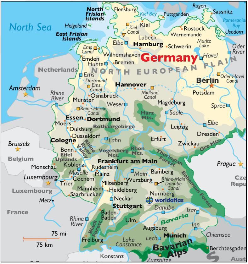 |
|
Canta- brian Mountains |
|
|
Sierra Nevada |
Spain 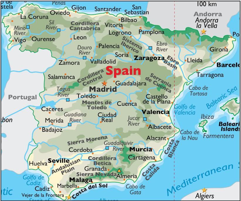 |
|
Grampian Mountains |
|
|
Pennine Mountains |
Ancient folded mountains spread across north and south England. |
|
Cambrian Mountains |
England 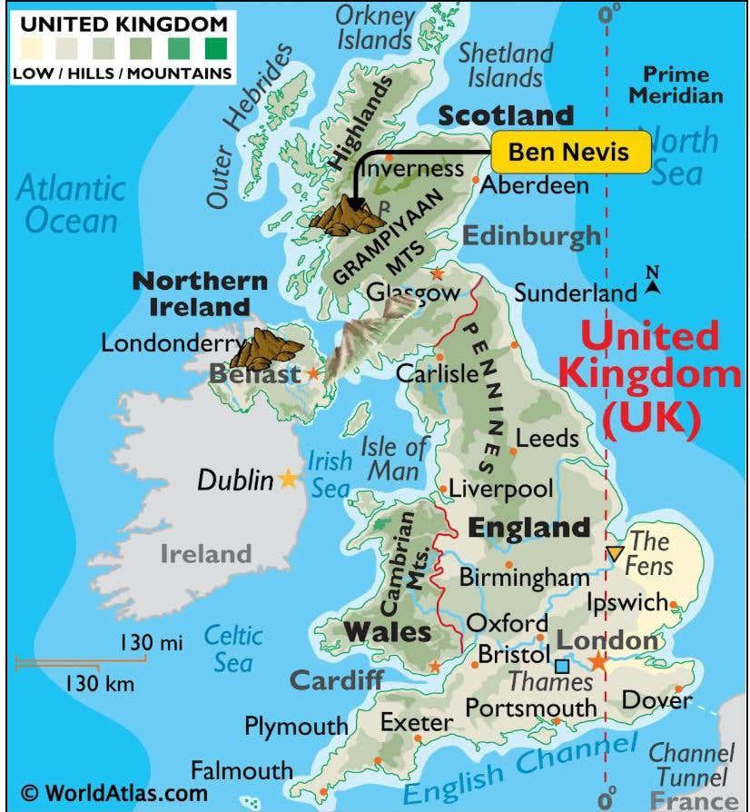 |
|
Carpa- thian Mountains |
|
|
Apennine Mountains |
|
|
Pindus Mountains |
|
|
Balkan Mountains |
|
|
Other Mountains |
 |
|
Ural Mountains |
|
|
Caucasus Mountains |
|
|
Russia |
|
|
Capitoline Mountains |
|
|
Mourne Mountains |
|
Oceani Mountains
|
Mountain |
Characteristics |
|
Eastern highlands |
|
|
Great Dividing Range |
|
|
The great Barrier Reef |
|
|
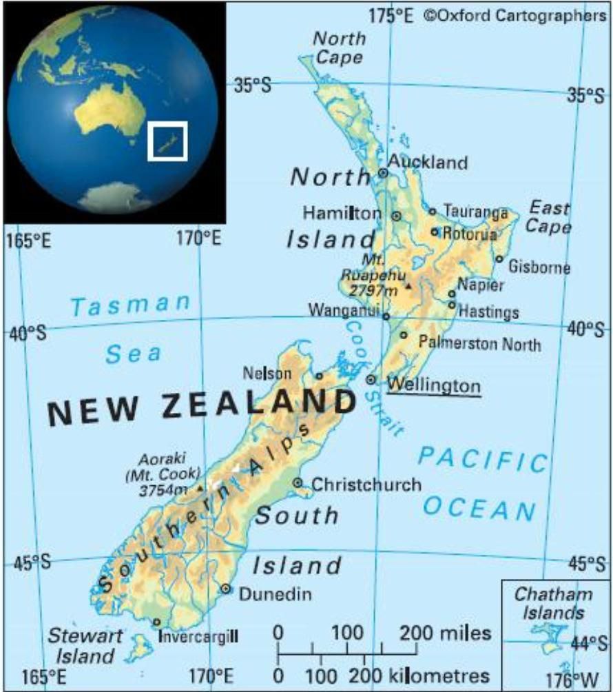
Southern Alps mountain range |
|
|
Macdonald series |
|
|
Broken Hills |
|
|
Philanders Mountains |
|
|
Darling Rage |
|
|
Mount Isa |
|
|
Mount grey range |
|
|
New Zealand |
 |