
Major Rivers of Rajasthan constitute an important topic in Rajasthan Geography, as they explain the drainage system and water availability of the state. Most rivers of Rajasthan are seasonal and rain-fed, influenced by the Aravalli Range, which acts as a major watershed. These rivers play a crucial role in agriculture, settlement patterns, and the overall socio-economic life of the region.
Major Rivers of Rajasthan
- Only 1.16% of the surface water of the country is available in Rajasthan.
- Out of 302 water blocks of Rajasthan, 216 are in the dark zone.
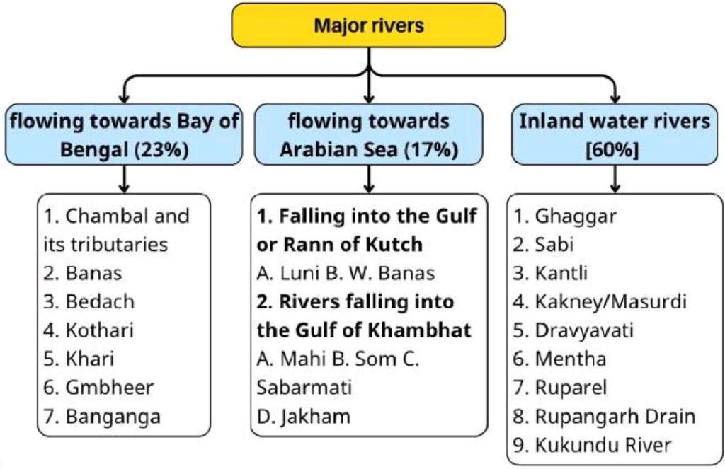
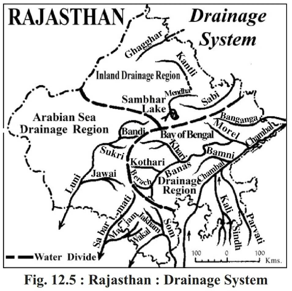
- The drainage system of Rajasthan can be divided into three parts:-
- Rivers flowing into the Arabian Sea (17%)
- Inland rivers (Endorheic rivers) (60%)
- Rivers flowing into the Bay of Bengal (23%)
Characteristics of the Drainage System
- The drainage system of Rajasthan mainly depends on the monsoon.
- The highest number of inland (endorheic) rivers in India is found in Rajasthan, because here rainfall is less and unevenly distributed.
- The Aravalli Range is called the “water divide”, as it separates the drainage system into two parts – rivers flowing into the Arabian Sea and rivers flowing into the Bay of Bengal.
Rivers of the inland drainage system
Ghaggar River
- The Ghaggar River is the longest inland river in the country.
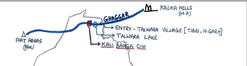
- Originates from Kalka Hills (Shivalik Range, Shimla, Himachal Pradesh). Also called Ancient Saraswati, Drishdwati, Dead River, and Sorrow of Rajasthan.
- Flows through Himachal, Punjab, Haryana, Rajasthan, and Pakistan.
- Flow in Rajasthan – Sri Ganganagar (entry – Talwara Village (Tibbi, Hanumangarh), Hanumangarh and from Anoopgarh it enters Pakistan.
- Home to Ancient Civilizations like Kalibanga, Pilibanga, and Rangmahal (Hanumangarh).
- The drainage area is called
- Naali/Paat (Hanumangarh)
- Hakra (Pakistan)
- Bhatner fort also located on this river.
Kantli River
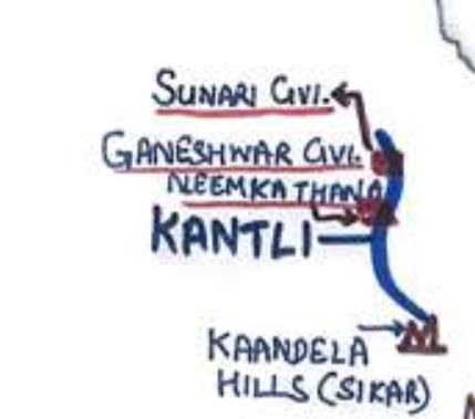
- Originates from Khandela Hill (Sikar) and flows through Sikar, Jhunjhunu, Neem ka Thana, dividing Jhunjhunu into two parts
- Length:- 100 km, Tributaries are Saap and Mavat.
- It is the longest river of internal drainage, which flows only in Rajasthan.
- The drainage of the Kantli river in Jhunjhunu and Churu region is called Toravati or Tanwarawati.
- Civilisations:-
- Ganeshwar Civilisation – Neem Ka Thana (Copper Age)
- Sunari Civilisation- Jhunjhunu (Iron Age)
Banganga River
- From 2012, it has been considered an internal river (before it was in the Bay of Bengal river system)
- Originates from Bairath Hills (Jaipur/Kotputli Behror) and after flowing through Jaipur, Dausa, Bharatpur, Kotputli-Behror, it disappears in the plains of Bharatpur.
- Also called – Arjun ki Ganga, Tala River
- Rundit Sarita – Due to ending before falling into the main river.
- Ancient Civilisation at its banks- Bairath Civilisation (Jaipur)
- Tributaries – Gumtinala, Palosan, Suri
- Major Dams –
- Lalpur Dam (Bharatpur)
- Ajan Dam (Bharatpur) – Water supply to the Ghana Bird Sanctuary
- Jamwa Ramgarh Dam (Jaipur) – Built by Ramsingh II, famous for rose cultivation.
- It will be connected to the Isarda dam located on the Banas River in Sawai-Madhopur.
Sabi/Sahibi River
- Originates from Sewar Hills (Jaipur/Kotputali Behror) and ends at Najabgarh Lake Patodi (Haryana)
- Flow:- Jaipur, Kotputli-Behror, Alwar
- The only river of Rajasthan flows toward Haryana
- Ancient civilisation – Jodhpura Civilisation (Jaipur)
Ruparel River
- Originates from – Udainath Hills (Thanagaji, Alwar) and after flowing through Alwar, Bharatpur, and Deeg. It is extinct at Kushalpur village (Bharatpur)
- Also called the Laswadi River, Varaha River.
- Sikri Dam (Bharatpur) is constructed on it, which supplies water to Moti Lake of Bharatpur.
- Moti Lake – life line of Bharartpur.
- The Sujanganga canal flows around the Lohagarh fort. And connect the Ruparel river to the Lohagarh fort.
Rupangarh River
- Originates from Slaemabad (Ajmer) and after flowing through Ajmer and Jaipur, falls into Sambhar Lake
- Nimbark Peeth (Salemabad, Ajmer) is situated on its bank.
Mentha River
- Originates from Manoharpura (Jaipur) and, after flowing through Jaipur, Didwana-Kuchaman, it falls into Sambhar Lake.
Kakni River
- Kakni is the smallest river of the internal drainage system in Rajasthan (17km).
- Also called – Kakaney River, Masurdi River
- Originates from – Kotri village (Jaisalmer) and extincts at Mithha Khadi
- Flows only in Jaisalmer
- Kakni is the most diverted river in Rajasthan.
- Bujh Lake – It is a sweet water lake situated in Rupsi village, Jaisalmer.
Other Important Rivers of Inland Drainage System
- Kukundu river – Bandh Baretha Sanctuary (Bharatpur)
- Dravyavati River – Jaipur (Dravyavati River front Project)
- Khandel River – Originates from khandela hills (Sikar)
- Khari River – Originates from Didwana -Kuchaman
- Turatmati River – Originates from Didwana-Kuchaman
Rivers flowing into the Arabian Sea
River falling into the Rann of Kutch
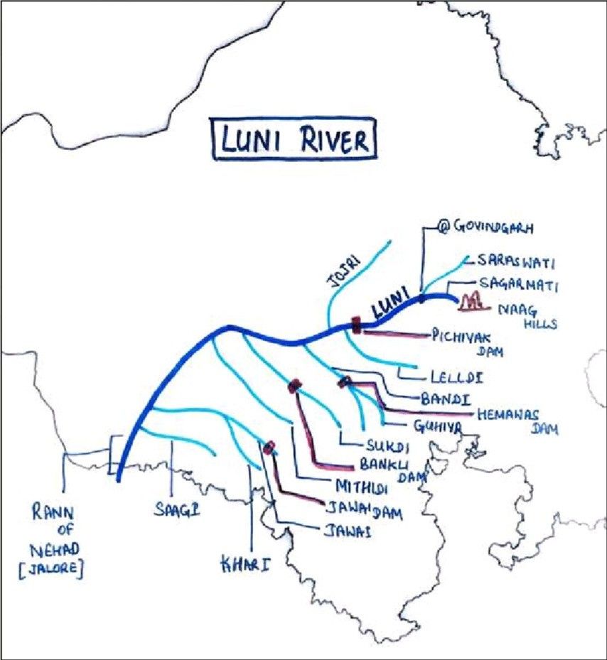
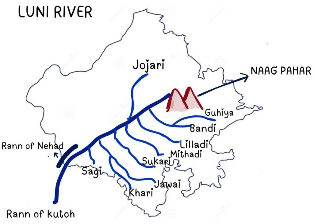
Luni River
- Its other names are Sagarmati (Ajmer), Saraswati, Lavanmati, Ganga of Marwar, Half-sweet, Half-salty river (after Balotra), “Antah salila” by Kalidasa.
- It is the longest river of western Rajasthan.
- It originates from Nag Pahar in Ajmer and, after flowing for 495 kilometres, disappears in the Rann of Kutch, Gujarat. Contributes 10.40% to the drainage system of Rajasthan.
- The total length of this river is 495 km. In Rajasthan, 350 km. It was totally dependent on rainfall.
- Ajmer, Beawar, Pali, Nagaur, Barmer, Balotra, Jalore and Jodhpur are catchment areas of the Luni River.
- Half-sweet River – from Nag hills to Balotara, Half-saline River – from Balotara to Rann of Kutch.
- Jojari, Leeladi, Sukari, Jawai and Bandi, Khari, Sagi Mithari, and Guhiya are its main tributaries.
- Its basin is called “Godwad Region”.
- Rel or Nada: The drainage system of the Luni River in Jalore and Sanchor is known as Rel/Nada.
- The ancient civilisation site Tilwada (Balotra) is located on its banks. Mallinath cattle fair is organised at Tilwara (Balotra).
Tributaries of the Luni River
- Jojari
- Origin – Podalu village from Nagaur district meets Luni at Khejarla Khurd, Jodhpur.
- Catchment – Nagaur, Jodhpur
- It is the only tributary of Luni that does not originate from the Aravali range.
- Only the right side tributary of the Luni.
- NOTE – Recently, the Jojari River was in the news due to increasing levels of pollution.
- Guhiya
- From Ajmer District
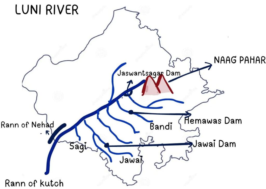
- Bandi
- This river originates from Hemawas /Phulad (Pali) and joins the Luni in Lakhar village in Jodhpur.
- Hemawas Dam is constructed on the Bandi River in Pali.
- Lildi River
- Originates from Jawaja, Ajmer, and meets Luni in Beawar district.
- Mithadi River
- Originates from the Aravali in Pali, meets Luni at Mangla Village, Balotra.
- Sukdi
- Desuri nal (Pali) and joins Luni in Samdari (Balotara)
- Jawai River
- It originates from the Goriya village of Pali tehsil. Meet Luni at Hemaguda Village, Barmer, after flowing through Pali, Jalore, and Barmer.
- Jawai Dam is located on it, called “Amritsarovar of western Rajasthan”.
- Khari
- Origin: This river is formed by the confluence of many small streams from the hills of Shergaon in Sirohi district.
- Sagi
- Originates from Jaswantpura hills in Jalore district and joins Luni in Gandhav village in Barmer.
- Catchment:- Jalore and Barmer.
Important dams built on the Luni River
- Bankli dam – On the Sukadi River at Jalore
- Jawai Dam – On Jawai River at Pali (Sumerpur)
- Water is supplied in Jawai dam from the Sei tunnel.
- Supplies water to Pali, Jodhpur, Sirohi and Jalore districts.
- Jaswant Sagar at Jodhpur on the Luni River, also known as Pichiyak Dam.
- Hemawas Dam – On Bandi River in Pali.
- The drainage area of Luni in Sanchore is known as Rail or Nada.
West Banas
- Originated from Naya Sanwara of Sirohi district.
- Total length is 226 km, and 50 km in Rajasthan.
- Confluence – Little Kutch (Gujarat) and the
- The catchment area of the west Banas is the Sirohi district.
- Tributary – Kukri, Sukli/Sipu. Abu (Sirohi) and Disa (Gujarat) cities are located on the banks of this river.
- Dams -1. Banas dam (Sirohi) 2.Gokul bhai bhatt (Sirohi)
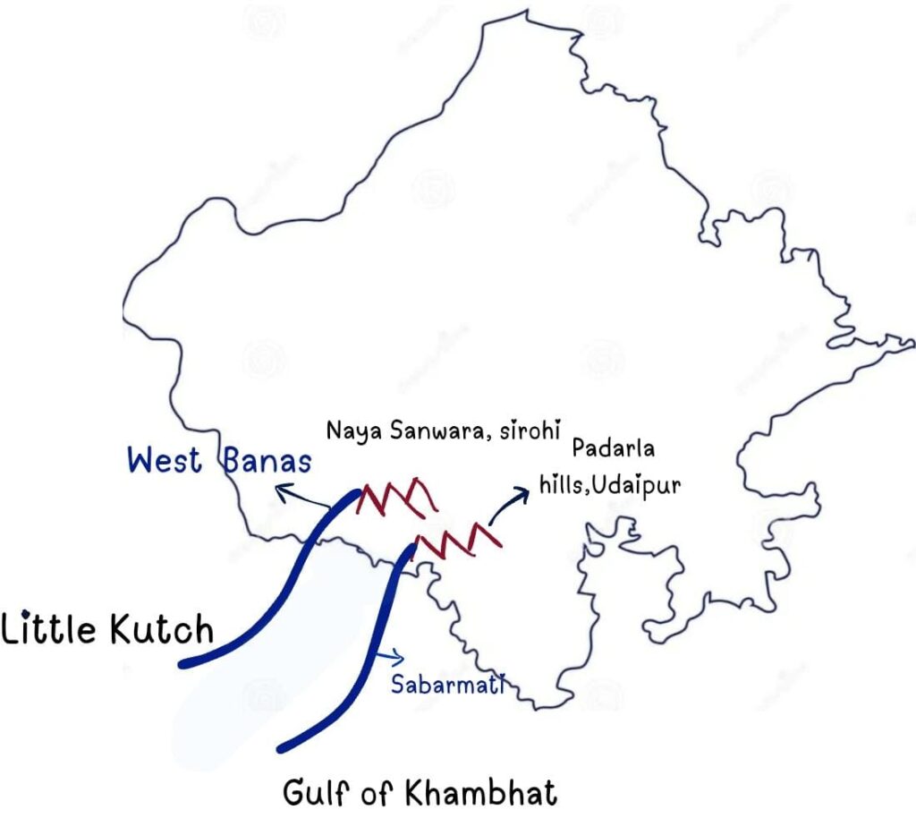
River falling into the Gulf of Khambhat
Mahi River
- Origin:- Mehand Lake (Amreru Hills –Vindhyachal Range)
- Entry in Rajasthan – Khandu village in Banswara.
- Discharge Point:- Gulf of Khambhat (Gujarat)
- Length:- 576 km (171 km in Rajasthan)
- Catchment Area:– Banswara (Maximum), Dungarpur, Pratapgarh.
- Tributaries:- Iru, Annas, Chaap, Moren, Som, Jakham
- Other Name of Mahi :
- Ganga of Tribes, Lifeline of tribes
- Kanthal ki Ganga (In Pratapgarh & Banswara)
- Vagad ki Ganga (Dungarpur & Banswara)
- Swarn Rekha River of Southern Rajasthan
- Triveni Sangam :
- The Mahi, Som and Jakham rivers meet at Beneshwar Dham (Nawatapra or Nawatpura).
- A fair is organised on the coast of this river, which is called “Kumbh of Tribes”. The most visited tribe at this fair is the Bhil.
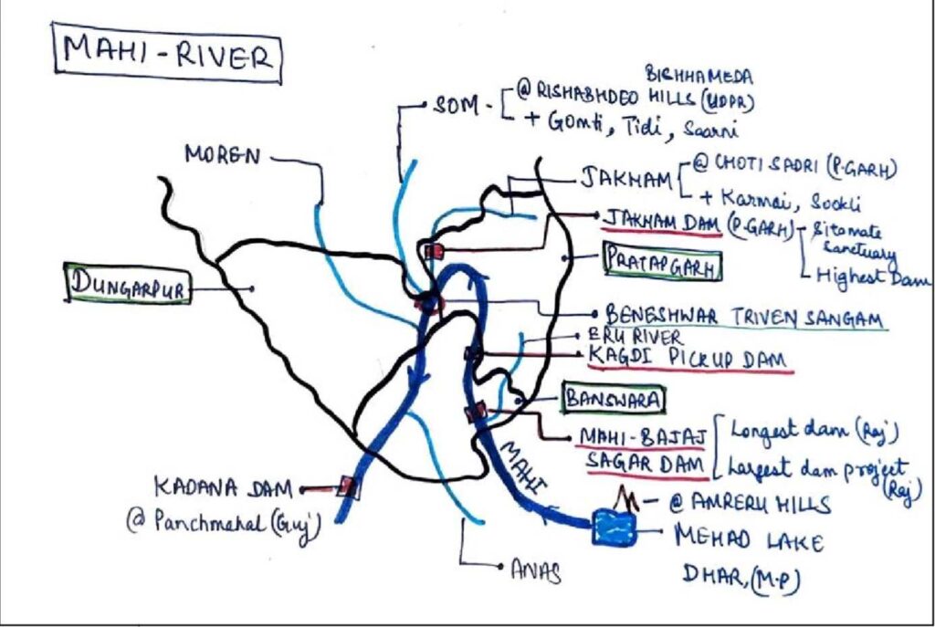
Tributaries of the Mahi River
| Tributaries of the Mahi River | ||
| Tributary | Origin | Joining point |
| Som | Bichhameda hills (Udaipur) | Baneshwar (Dungarpur) |
| Jakham | Bhabarmata, Chhoti sadari (Pratapgarh) | Baneshwar (Dungarpur) |
| Iru | Banswara | Banswara |
| Anas | Amber village (M.P) | Dungarpur |
| Chaap | Kalinjara Hills, Banswara | Dungarpur |
| Moren | Dungarpur | Galiakot, Dungarpur |
- Mahi is the only river in the world that crosses the Tropic of Cancer twice.
- The Mahi River is the only river of Rajasthan which enters from the south of Rajasthan, and then this river flows westward.
- Sujalam – Suphalam :
- It is a cleaning project for Mahi.
- Empowered by BARC (Bhabha Atomic Research Centre).
Dam Project
- Mahi Bajaj Sagar :
- It is located in Borkheda (Banswara), and its total length is 3109 meters.
- It is the longest dam project of Rajasthan and the largest dam project of the tribal area.
- Kagdi Pickup Dam – Banswara
- Kadana Dam – Gujarat
- Jakham Dam :
- It is located in Sitamata Sanctuary (Pratapgarh), and it’s the highest dam (81 meters) in Rajasthan.
- Som – Kagdar Project – Udaipur
- Som Kamla-Amba project – Dungarpur on Som river.
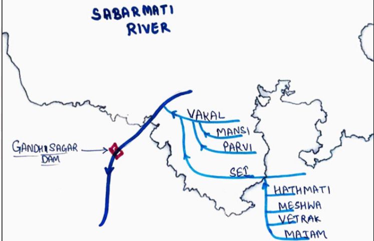
Sabarmati
- This river originates from the Padrana Hills in Udaipur and drains its water into the Gulf of Khambhat in Gujarat.
- The total length of this river is 416 km, and in Rajasthan 45 km.
- The catchment area of Sabarmati in Rajasthan is Udaipur.
- Main Tributaries of Sabarmati are Vetrak, Sei, Hathmati, Meshwa, Mansi – Wakal, Majam and Harnav.
- Sei and Mansi-Wakal (Udaipur) are the main Water tunnels of Sabarmati.
- From the Sei tunnel (Udaipur), water is supplied to the Jawai dam (Pali).
- Mansi-Wakal (Udaipur) tunnel is the longest water tunnel of Rajasthan.
Rivers flowing towards the Bay of Bengal
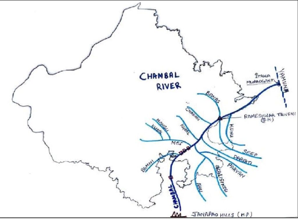
Chambal River
- Also called as Charmanvati River, Kamdhenu, Barahmasi
- Origin:- from Janapav hill near Manpur town, Mhow tehsil (Vindhyan Mountain) and joins the Yamuna in Uttar Pradesh (Etawah).
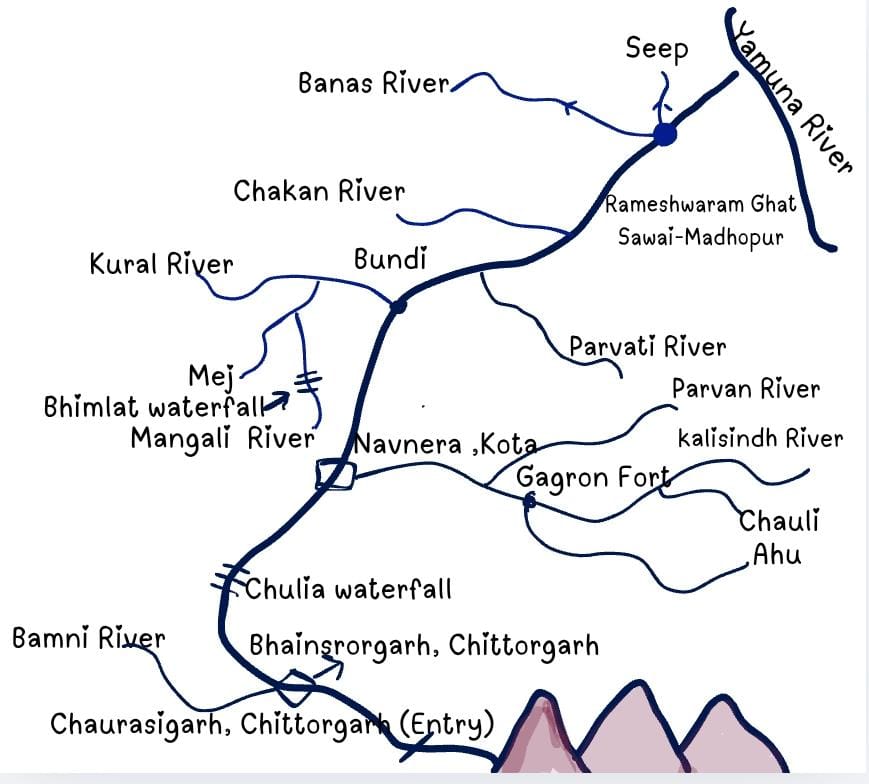
- It enters Rajasthan near the Chaurasigarh fort (Chittorgarh) and forms the border of Kota and Bundi districts, which form the border of Sawai Madhopur – Kota and flows along the Rajasthan and Madhya Pradesh border.
- The total length of the Chambal is 1051 km in Rajasthan. Its length is 322 km.
- Chittorgarh, Kota, Bundi, Karauli, Sawai Madhopur and Dholpur are the catchment Areas of the Chambal River.
- According to old data in Rajasthan, the Chambal River covers a distance of 135 km, while its total length is 965 km. (New – 1051 km. Rajasthan- 322)
- Before entering Rajasthan, the river bed was about 300 meters wide, but after that, its valley became narrow.
- Chulia Falls is 5 km away from Chaurasigarh. After this, the river flows through a narrow valley (gorge) till Kota. In Sawai Madhopur and Dholpur districts, ravines have been formed due to excessive erosion in the areas near the Chambal River.
- Parvan, Brahmani, Banas (the longest tributary of Chambal), Chakan, Kunu, Kural and Seep, Gunjali, Maij, Mangli, Parvati, Newaj, Aahu, Kalisindh (the longest tributary from the right side), Ghoda – Pachad are tributaries of Chambal.
- Gagron fort is located on the banks of the Kali Sindh and Ahu.(Samela)
Facts related to the Chambal River
- The Chambal River forms the largest interstate boundary with Madhya Pradesh.
- Confluence:– forms at Rameshwaram Ghat (Padra – Sawai Madhopur) with Banas and Seep Rivers.
- Chulia waterfall is located in Bhainsrorgarh (Chittorgarh) on the Chambal River.
- Badland topography by gully erosion is formed by the Chambal river in Karauli, Sawai Madhopur and Dholpur.
- Hanging Bridge – India’s 4th and Rajasthan’s first bridge, located on the Chambal River.
Right Bank Tributaries of Chambal
- Kalisindh– 145 km.
- Originates from the hills of Bagli Village, Devas, Madhya Pradesh.
- Flows through Jhalawar, Baran, Kota and meets Chambal at Naunera, Kota.
- Harishchandra Sagar Dam (Jaitpur, Jhalawar) and Navnera barrage dam (Kota) are located on it.
- Its tributaries are Ahu (Gagron fort is situated at the confluence), Chandrabhaga, Parwan, Ujaad, and Chouli Rivers.
- Samela:- The confluence of Kalisindh and Ahu is called Samela.
- Parvan:–
- Originating from Madhya Pradesh, it enters Rajasthan near Kharibor village in Jhalawar.
- Flows through Jhalawar, Kota and Baran and meets Kalisindh near Rajgarh – Palayta (Baran) on the border of Kota. Manoharthana Fort is located on the Parvan River in Jhalawar.
- Kalikhad, Dhar and Chhapi are its tributaries of parvan river.
- Shergarh Sanctuary in Baran district is near this river.
- Parvati – 70 km.
- Originates from the Vindhyachal range from Sehore, Madhya Pradesh, flows through Baran and Kota and meets Chambal at Pal ghat, Sawai Madhopur – Kota border.
- It enters Rajasthan from Kariahat, Baran
- Its tributaries are – Andheri, Retri, Bainthli, and Bilas.
Left Bank Tributaries of Chambal River
- Bamani/Brahmani–
- Originates from Haripura Village in Chittorgarh and meets the Chambal near Bhainsrodgarh Fort after flowing through Neemuch, Madhya Pradesh.
- Bamani – Banas project of 89 kilometres is proposed to bring water from Bamani to Bisalpur Dam.
- Kural River:-
- Origin:- Umalmal plateau in Bhilwara, it joins the Chambal at Bundi district.
- Mej River –
- Originates from Bijoli, Bhilwara and meets Chambal at Lakheri Bundi
- Its tributaries are the Bajan Kural Mangli.
- Mangali River:-
- A tributary of the Mej River, Bhimlat waterfall is located on this river.
Other Tributaries of Chambal
- Alania
- Originates from Mukundwada Hills, also called the Chandralohi River. The Alania dam is constructed over it.
- Chakhan
- Originates from Bundi and, after flowing through Bundi and Sawai Madhopur, meets the Chambal at Karimpur (Sawai Madhopur). The Chakhan dam has been constructed near Nainwa (Bundi).
- Aahu
- Originates from Susner, Madhya Pradesh. Flows through Kota and Jhalawar and meets Kalisindh at Gagron, forming “Samela” here. Gagron Fort is located.
- Kunu
- Originates from the Shivpuri plant in Madhya Pradesh. Chandrabhaga originates from Seemli, Jhalawar, and merges with the Kalisindh River at Kadia village, Jhalawar.
- Nimaj
- Originating from the northern part of the Vindhya mountains in Madhya Pradesh.
- Godhapachhad and Gujali rivers are Tributaries.
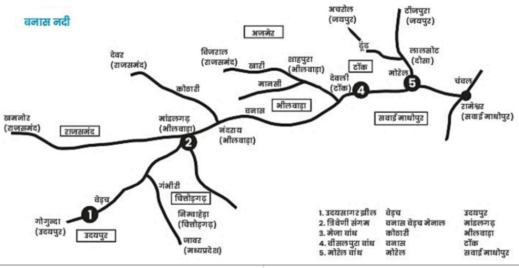
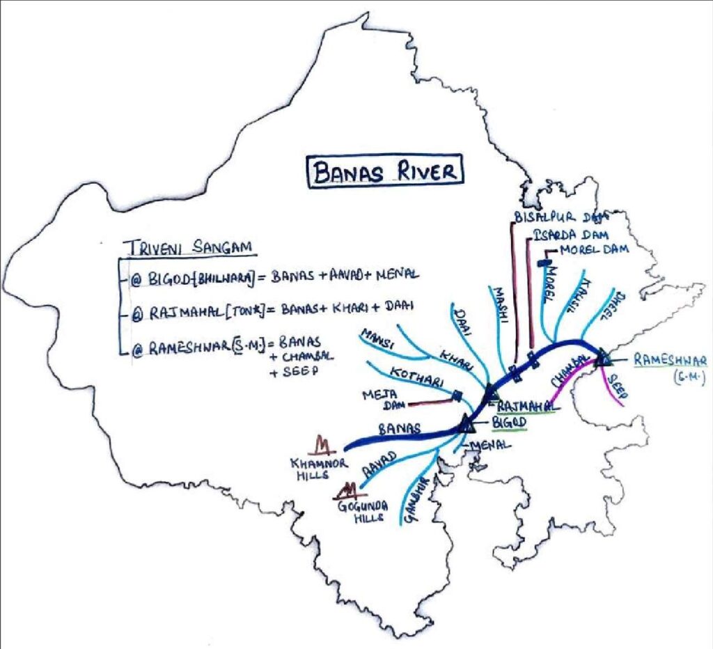
Banas River
- Also known as Hope of Forest, Vashishthi River
- The Banas is the longest river flowing in Rajasthan.
- This river originates from the Khamnor hills of the Bhorat plateau and joins the Chambal at Rameshwar in the Sawai Madhopur district.
- The main tributaries of this river are Berach (the largest tributary of Banas from the right side), Kothari, Khari, Menal, Kalisil, Dai, Bandi, Mansi, Dhoondh and Morel.
- The total length of the Banas River is 512 km at present.
- Bhilwara, Rajsamand, Chittorgarh, Ajmer, Tonk, and Sawai Madhopur are the catchment areas of the Banas River.
Dam projects located on the Banas and its tributaries
- Bisalpur Dam -In Tonk, constructed in 1999.
- The Basalpur dam is the largest drinking water project of Rajasthan, constructed though concrete.
- Tonk, Ajmer, Nagaur, Jaipur, Dausa, and Sawai Madhopur are the most benefited districts from this project.
- Bisalpur Dam is connected to the Eastern Rajasthan Canal Project
- The excess water of the Bisalpur dam is connected to the Isarda dam.
- Bisalpur is the first conservation reserve declared in 2008.
- This project is funded by NABARD.
- Other dams located on the Banas river:- Morel dam, Meza dam and Galwa dam.
- Isarda Dam – Sawai-Madhopur
- Nandsamand Dam -Rajsamand
- Matrikundia Dam -Chittorgarh
- Tordi sgar dam – Tonk (Sahoda river)
- Galva dam – Tonk (Galwa river)
Sangam on the Banas River
| Sangam on the Banas River | |
| Chambal, Seep, Banas | Rameshwar (Sawai Madhopur) |
| Khari, Dai, Banas | Rajmahal (Tonk) |
| Banas, Berach, Menal | Bigod (Bhilwara) |
Right Bank Tributaries of the Banas River
- Berach River
- The river is called Aayad before Udaisagar Lake, and after that it is called Bedach.
- The origin points of the Berach River are the Gogunda Hills (Udaipur).
- Discharge Point is Bigod in Bhilwara.
- Catchment Area – Udaipur, Chittorgarh, Bhilwara.
- Gambhir River is the main tributary of the Berach River.
- Fact – Chittorgarh Fort is located on the confluence of the Bedach and Gambhir.
- Gambhiri River
- Originates from the Javad hills in Madhya Pradesh and enters Rajasthan through Chittorgarh. It is a tributary of the Berach River.
- NOTE:- Another Gambhiri River, which is part of yamuna river system, flows in karauli district of Rajasthan, and the Pachana dam is located on it.
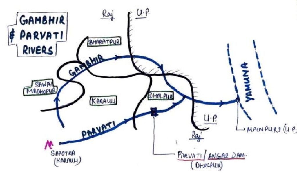
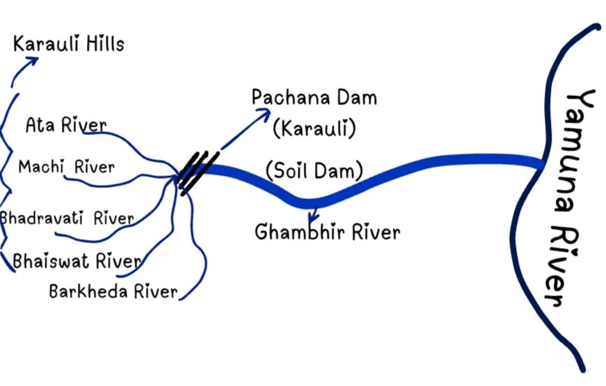
- Gambhir River
- Originates from the hills of Nadothi Village, Saputara Karoli.
- Also called the Uttanga River in Uttar Pradesh and Parvati in Dholpur It meets the Yamuna River at Rithvillage, Agra.
- Tributaries are Panchna, Parvati, Khaer Machi, Ata, Bhadravati, and Barkheda.
- The Panchna dam is built over the Panchna River (the dam is made of mud with the assistance of the USA)
- Menal River:-
- Origin – Menal (Chittorgarh)
- Discharge Point is Bigod in Bhilwara.
Left Bank Tributaries of the Banas River
Kothari River
- Originates from Diwer, Rajamand, and meets Banas at Nandhini Shahpura, Bhilwara.
- The Meja dam is constructed on it, which provides drinking and irrigation water to Bhilwara. Bagor civilisation was excavated on its banks.
Khari River
- Originating from the hills of Bijal Village flows through Rajsamand, Bhilwara, Beawar and Tonk. Then meets Banas at Rajmahal (Deoli) after flowing for 80 km. Tributary – Mansi.
- Dams – Narayan Sagar Dam (Beawar) and Khari Dam (Asind)
Daai River
- Originates from the Kishangarh hills and meets the Banas at Rajmahal (Triveni) after flowing through Ajmer and Tonk.
Mashi–
- Originates from Kishangarh (Ajmer) and after flowing through Ajmer & Tonk, meets the Banas River at Devdham, Jodhpuriya (Tonk)
Morel–
- Originates from the hills of Chainpura Village, Bassi and flows through Dausa and Sawai Madhopur and meets banas at the Karauli – Sawai Madhopur border.
- Morel Dam is on Morel River
- Dhundh – tributary of Morel River
- Dravavati, a tributary of the Dhundh originate from the Nahargarh hills, Jaipur, facing the highest pollution.
- Kalisil – Originates from Saputara, Karauli and meets the Banas at Karauli, Sawai Madhopur border (tributary of Morel).
- The famous Keladev temple is located on the bank of this river.
Other tributaries of the Banas River
- Mansi Originates from Mangalod and meets Khaari at Phulia Kalan (Bhilwara)
- Dheel – Tributary of Banas, originating from Baawli Village (Tonk) and flows through Tonk and Sawai Madhopur.
- Chandrabhaga – Originates from Devado ka Gudha, Amet (Rajsamand) and meets the Banas at Matrikundiya
- Parvati Originates from the Chawar Hills of Karauli and meets the Gambhir River at Kharagpur Dholpur. Parvati/ Angai Dam is built on it.
Important facts related to Rivers
| River | River System |
| Sabi Sagi | Internal River system Luni River System |
| Moren Morel | Mahi River System Banas River System |
| Sukadi Sukali | Luni River system West Banas River |
| Khari Khari Khari | Banas River System Luni River system Internal River System |
| Kantali Kankani | Internal River System Internal River System |
| Sipu(sukali) Seep | West Banas River System Chambal River System |
| Kalisindh Kalisil | Chambal River System Banas River System |
| Bandi Bandi | Banas River System Luni River System |
| Manshi Mansi | Sabarmati River System Banas River System |
| Gambhir Gambhiri | Yamuna River System Bedach River System |
Waterfalls in Rajasthan
| Chulia waterfall | Chambal River (Chittorgarh) |
| Bhimlat waterfall | Mangali River (Bundi) |
| Menal Waterfall | Menal River (Bhilwara – Chittorgarh) |
| Arnna – Jharnna waterfall | Jojari River (Jodhpur) |
Some Important Facts
|
Rivers of Rajasthan |
|
Minimum Rivers in Rajasthan ->District – Bikaner and Churu Division – Bikaner |
|
Maximum Rivers in Rajasthan ->District – Chittorgarh Division – Kota |
|
|
|
Order of the river based on the drainage system:-
|
|
|

DEEPAK SHARMA