
Space technology : Satellites and their orbits is an important branch of the subject Technology, helping us explore space and improve life on Earth through innovations like satellites and launch vehicles. It plays a key role in communication, weather forecasting, and scientific discoveries.
In this chapter, we will study the following topics:
- Satellites and their orbits ; Remote sensing
- Indian space programme & Institutional Setup
- Various launch vehicles
Previous year Questions
| Year | Question | Marks |
| 2024 | Critically evaluate the strategic and technological importance of indigenization in defence production, especially in missile and space technologies of India. | 10 M |
| 2023 | Write a brief note on “ADITYA-L1’ mission. | 5 M |
| 2021 | What is the difference between Polar Satellite launch vehicle and Geosynchronous Satellitelaunch vehicle? | 2 M |
Space technology : Satellites and their orbits
What is Space Technology:
Space technology is a branch of science and engineering focused on designing, developing, and deploying systems like satellites, spacecraft, and rockets. It enables space exploration, observation, and practical applications for human benefit, such as communication, disaster management, and environmental monitoring.
Brief History of Space Exploration
Early Rocketry and the Birth of Space Technology (Early 20th Century)
- 1903: Konstantin Tsiolkovsky’s rocket equation and concepts of space travel.
- 1926: Robert Goddard launched the first liquid-fueled rocket.
- 1944–1945: Development of the V-2 Rocket – Under the leadership of Wernher von Braun, Germany
The Space Race during the Cold War (1950s–1970s) to Present
Cold War Space Race & Beyond
- 1957: Sputnik 1 & 2 (First satellite & living being, USSR)
- 1958: Explorer 1 (First U.S. satellite, Van Allen belts)
- 1959: Luna 2 (First Moon impact, USSR)
- 1961–69: Gagarin (First human, USSR) → Mariner 2 (Venus, USA) → Luna 9 (Soft Moon landing, USSR) → Apollo 11 (Moon landing, USA)
- 1971–77: Mariner 9 & Mars 3 (First Mars orbit & landing) → Luna 17 (First lunar rover) → Voyager 1 (Left solar system, USA)
- 1981–98: Columbia (Reusable shuttle) → Challenger (Tragedy) → ISS (Global collaboration)
Private Space Companies and the Future of Exploration (2000s-Present):
Private companies like SpaceX (by Elon Musk), Blue Origin(by Jeff Bezos), and Virgin Galactic (by Richard Branson) have revolutionized space exploration.
- SpaceX: Falcon 9, Crew Dragon (Cheaper space travel, NASA partner), Dear Moon Project (Canceled, 2023)
- Blue Origin: New Shepard (Suborbital flights, Bezos flew in 2021), New Glenn (Future orbital), NS-25 (Gopichand Thotakura on crew)
- Virgin Galactic: SpaceShipOne (Ansari X Prize, 2004), SpaceShipTwo (Commercial flights soon)
Ongoing & Future Missions
- 2020s: Artemis (Moon return, 2024–28), Europa Clipper (Jupiter’s moon, 2024)
- 2030s: Mars Sample Return (NASA–ESA, Martian soil)
- 2021: James Webb Telescope (Exoplanets, galaxies, star formation)
- Commercial Future: Mars missions, suborbital tourism (SpaceX, Blue Origin, Virgin Galactic
Orbits
An orbit is the curved path that an object (like a planet, moon, satellite, or spacecraft) follows as it moves around another object due to the force of gravity. For example, the Earth follows an orbit around the Sun, and the Moon orbits around the Earth.
An orbit is the result of two forces acting on an object:
- Gravitational force: The force that pulls the object towards the central body (e.g., the Sun, Earth). ⇒ Centripetal Force
- Inertia: The object’s tendency to move in a straight line at constant speed. ⇒ Centrifugal force (Apparent force) in the orbiting frame.
These two forces balance each other to keep the object in a continuous curved path.
Key terms:
- Orbital Velocity: The speed at which an object must travel to stay in orbit, balancing the pull of gravity and its forward motion.
- Perigee: The point in an orbit that is closest to the central body (e.g., closest to Earth).
- Apogee: The farthest point in an orbit from the central body (e.g., farthest from Earth).
- Elliptical Orbit: An oval-shaped orbit, where the object moves closer and farther from the central body.
- Circular Orbit: A special case where the orbit is perfectly round.
Note: Kepler’s Laws describe the motion of objects in orbit around a central body.
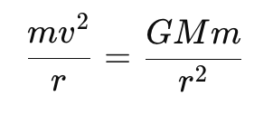
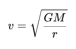
Orbital velocity
- It refers to the speed at which an object must travel to remain in a stable orbit around a planet or celestial body.
- The centripetal force needed to keep an object in orbit is the gravitational force between the object and the central body.
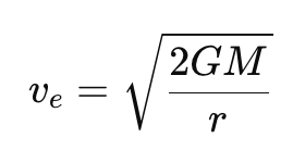
Escape Velocity
- Escape velocity is the minimum speed required for an object to escape the gravitational pull of a planet or celestial body without any further propulsion.
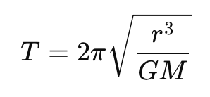
Orbital Period
- The orbital period is the time taken by an object to complete one full orbit around its central body.
- For a circular orbit, the orbital period T is related to the radius rr and the mass of the central body M:
Types of Orbit
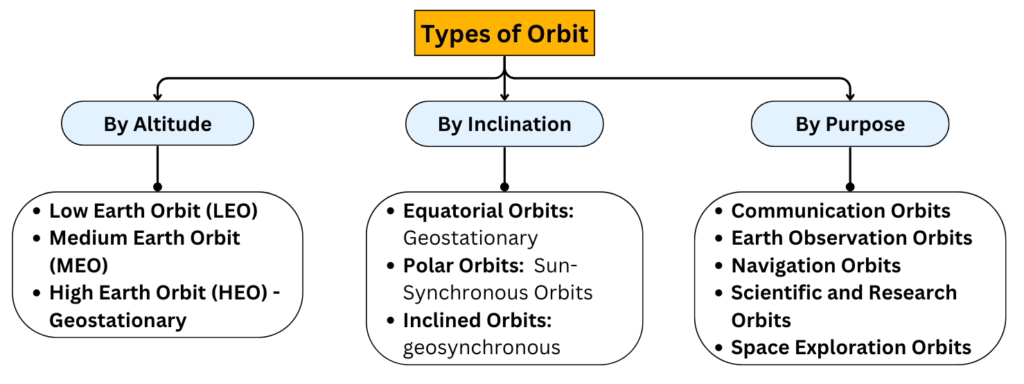
By Altitude:
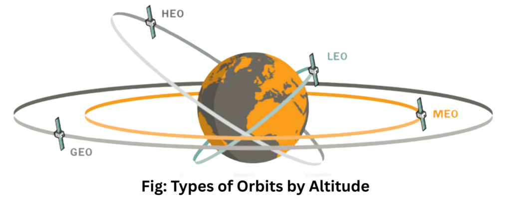
1. Low Earth Orbit (LEO)
- Altitude: 160 km to 2,000 km above Earth’s surface.
- Characteristics:
- Approximately 90 to 120 minutes to complete one orbit.
- Orbital Velocity: Depends on altitude. Eg. At 200 km: ~7.8 km/s (28,000 km/h).
- Proximity allows high-resolution imaging and lower communication latency.
- Subject to atmospheric drag, requiring occasional adjustments to maintain altitude.
| Advantages | Disadvantages |
| 1. Low energy for launches. | 1. Limited field of view. |
| 2. Fast communication with low latency. | 2. Orbital decay requires re-boosting. |
| 3. Less powerful transmitters needed. | 3. Large constellations needed for coverage. |
| 4. Easy servicing and replacement. | 4. High collision risk with space debris. |
| 5. Cost-effective to launch and maintain. | 5. Shorter lifespan due to drag. |
- Applications:
- Earth observation, Disaster management, spy satellites and satellite imaging. Ex. Rohini Satellite, RISAT-2B, EOS-01
- Space stations e.g., the International Space Station(ISS), Tiangong space station (China).
- Communication systems like satellite internet constellations. Example : Starlink (SpaceX), OneWeb, Amazon Kuiper Project
- Note: Satellites in LEO can see only a small portion of Earth at any given time, but constellations like Starlink work together to provide continuous coverage.
- Astronomical observations. Example: Hubble Space Telescope, AstroSat (Indian astronomy mission).
- Space tourism companies like Virgin Galactic and Blue Origin aim to use LEO for suborbital spaceflights.
2. Medium Earth Orbit (MEO)
- Altitude: 2,000 km to 35,786 km above Earth’s surface.
- Characteristics:
- Orbital period ranges from 2 to 12 hours.
- Speed: Lower than LEO, but higher than GEO.
- Applications: MEO is used for satellites that need a balance between the advantages of LEO and GEO orbits.
- Global Navigation Satellite Systems (GNSS): MEO is the standard orbit for positioning, navigation, and timing (PNT) satellites. Examples:
- GPS (USA) – Altitude: ~20,200 km, GLONASS (Russia), Galileo (Europe), BeiDou (China)
- These systems use semi-synchronous orbits (12-hour orbital periods), passing over the same equator spots daily.
- Communication Satellites: Example: SES O3b and O3b mPOWER provide low-latency broadband for remote, maritime, and aero locations.
- Global Navigation Satellite Systems (GNSS): MEO is the standard orbit for positioning, navigation, and timing (PNT) satellites. Examples:
|
Advantages of MEO |
Challenges of MEO |
|
|
3. High Earth Orbit (HEO)
- A High Earth Orbit is a geocentric orbit with an apogee farther than the geosynchronous orbit (35,786 km or 22,236 mi above Earth).
- Orbital Period: Longer than 24 hours, depending on the orbit’s altitude and shape.
- Types of HEO:
- GEO: Geostationary Orbit; GSO: Geosynchronous Orbit; GTO: Geostationary Transfer Orbit; HEO: Highly Elliptical Orbit; NRHO: Near-Rectilinear Halo Orbit.
- Applications:
- Communication and Navigation: Limited applications due to delay but useful for global broadcasting or redundancy.
- Scientific Research: Ideal for astronomical observatories and Earth science missions requiring a wide view or deep-space perspective.
- Military: Surveillance, strategic communication, and navigation.
- Example Satellites:
- TESS (Transiting Exoplanet Survey Satellite) for exoplanet discovery.
- Communication satellites with specific global or regional coverage needs.
|
Advantages |
Challenges |
|
|
Special Case →
Highly Elliptical Orbit (HEO): A highly elliptical orbit is a type of HEO with:
- A low perigee (as low as 2,000 km).
- A high apogee (potentially extending beyond GEO).
- High inclination, often used for high-latitude coverage.
- Example Use Cases: Space telescopes to avoid Earth’s shadow.
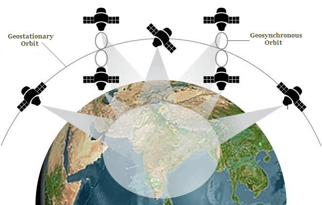
Geosynchronous Orbit (GSO)
- A satellite with an orbital period matching Earth’s rotation (23h 56m 4s), completing one orbit per day.
- Characteristics:
- Altitude: Located at an altitude of approximately 35,786 km (22,236 miles) above Earth’s surface.
- Orbit can be inclined, not necessarily equatorial.
- Appears as a figure-eight (analemma) when viewed from the ground.
- Uses:
- Ideal for applications like communications or scientific observations without needing a fixed ground position.
- Weather satellites observing wide Earth areas may use inclined GSO.
- Example: GSAT series, KALPANA-1, Bhaskara-I
Geostationary Orbit (GEO)
- A geostationary orbit is a special case of geosynchronous orbit where the satellite orbits directly above Earth’s equator (0° inclination) and appears stationary relative to a specific point on the Earth’s surface.
- 1945: Arthur C. Clarke popularized the concept of geostationary satellites for global communications. This orbit is sometimes called the “Clarke Orbit” or the “Clarke Belt.”
- First Satellite: Syncom 3, launched in 1963, was the first to achieve GEO.
- Characteristics:
- Altitude: Approximately 35,786 km above Earth’s equator
- Direction: Satellite orbits in the same direction as Earth’s rotation (prograde).
- The orbit must be circular and in the same plane as the equator.
- Orbital period matches Earth’s rotation: 23 hours, 56 minutes, and 4 seconds.
- Applications:
- Communications: Used for broadcasting TV, radio, and internet services, especially for areas without terrestrial networks.
- Meteorology: Real-time weather monitoring via satellites like GOES (US), Himawari (Japan), INSAT (India), and Meteosat (Europe). Applications include tracking cyclones, measuring cloud properties, monitoring vegetation, and predicting volcanic ash dispersion.
- Navigation: Enhances GNSS (Global Navigation Satellite Systems).
- Scientific Research: Some satellites in GEO support Earth observation and data relay missions for deep-space probes.
- Launch Requirements:
- Satellites are launched into a geostationary transfer orbit (GTO), then use onboard propulsion to circularize their orbit at GEO altitude.
- Proximity to the equator (e.g., Guiana Space Centre) reduces inclination change and uses Earth’s rotation for additional speed.
- Fact: Only three satellites in GEO can provide coverage of the entire Earth.
|
Advantages |
Challenges |
|
|
Differences between GSO and GEO:
| Aspect | Geosynchronous Orbit (GSO) | Geostationary Orbit (GEO) |
| Inclination | Can have any inclination; not limited to the equatorial plane. | Fixed at 0° inclination (over the equator). |
| Ground Appearance | Satellite appears to move in a figure-eight path (analemma). | Satellite appears stationary from Earth. |
| Applications | Broader range of uses, including scientific and specialized observations. | Ideal for constant monitoring of a specific region (e.g., TV broadcasting, weather). |
| Coverage Area | Changes depending on inclination. | Covers the same area at all times. |
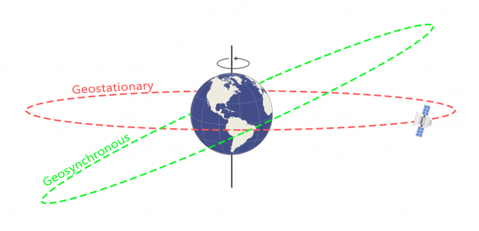
- All geostationary orbits are geosynchronous, but not all geosynchronous orbits are geostationary.
- GEO is a subset of GSO, optimized for constant monitoring of specific regions.
Polar Orbit and Sun-Synchronous Orbit (SSO)
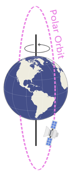
Polar Orbit:
Satellites in this orbit pass over the poles, traveling from north to south. This allows for complete global coverage over time as Earth rotates beneath the satellite.
- Altitude: Typically 200 km to 1,000 km.
- Launch Requirements: More energy is required to achieve a polar orbit than an equatorial orbit due to the inability to use Earth’s rotational velocity.
- Applications:
- Earth observation (weather, climate monitoring, reconnaissance, disaster mapping). Eg. NOAA’s Satellite
- Environmental and agricultural studies.
- Telecommunications: E.g., Iridium satellite constellation uses polar orbits for global communication coverage.
Sun-Synchronous Orbit (SSO):
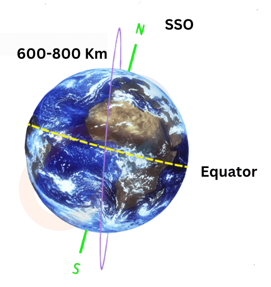
A special type of polar orbit where the satellite’s path is synchronized with the Sun. This means the satellite always passes over the same region at the same local solar time (e.g., noon every day).
- Altitude: ~600–800 km.
- Ideal for consistent lighting conditions for imaging and data collection.
- Precession: Satellite’s orbit gradually shifts to maintain a constant angle with respect to the Sun.
- Applications : Consistent remote sensing and time-series analysis
- Ideal for long-term monitoring of weather, forest fires, deforestation, flooding, and rising sea levels.
- Enables precise comparison of images over time due to consistent solar illumination.
- Examples : Cartosat Series, Oceansat Series, SARAL (ISRO) etc
Difference Between Polar Orbit and Sun-Synchronous Orbit (SSO)
| Aspect | Polar Orbit | Sun-Synchronous Orbit (SSO) |
| Definition | Orbits passing near the poles, covering the whole Earth over time. | A type of polar orbit synchronized with the Sun, maintaining consistent lighting conditions. |
| Inclination | ~90° or slightly deviated (up to 20°–30°). | ~96°–98° to achieve Sun synchronization. |
| Altitude | 200–1,000 km (Low Earth Orbit). | Typically 600–800 km. |
| Synchronization | Not synchronized with the Sun. | Synchronized to pass the same spot at the same local solar time daily. |
| Lighting Conditions | Varies across orbits. | Maintains consistent lighting, e.g., constant dawn/dusk. |
| Uses | Global mapping, reconnaissance, and environmental monitoring. | Long-term Earth monitoring, weather prediction, deforestation tracking, and disaster management. |
| Examples | General Earth observation satellites. | Remote sensing satellites like ISRO’s Cartosat series or NASA’s Landsat series. |
Transfer Orbits
Special orbits used to transition a satellite or spacecraft from one orbit to another using minimal energy. It saves energy by using built-in motors to adjust eccentricity and achieve the desired orbit (higher or lower). Eg GTO
Geostationary Transfer Orbit (GTO):
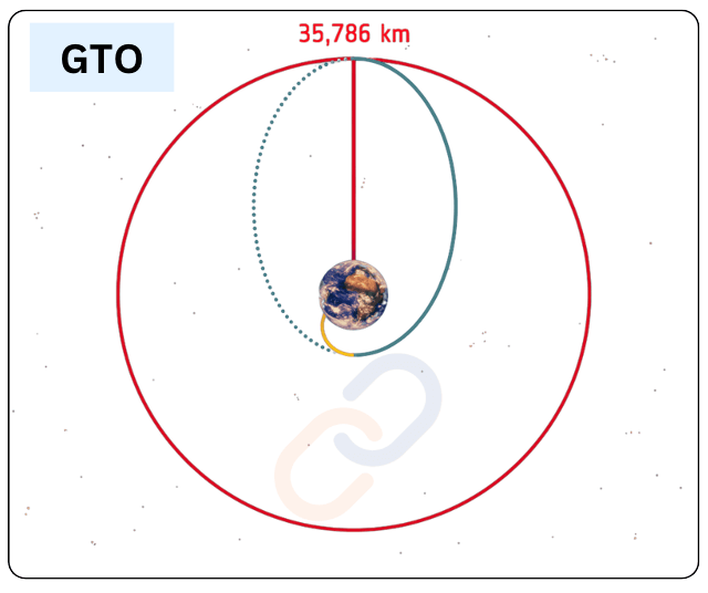
A common transfer orbit used to move satellites from LEO or MEO to GEO. Example: Communication satellites launched by Ariane 5 or Falcon 9.
- Advantage: GTO saves fuel and allows smaller rockets to deploy large satellites into GEO.
- Applications: Commonly used for satellites intended for geostationary applications (e.g., communication, broadcasting). Eg. Communication satellites GSAT-31 (ISRO).
Hohmann Transfer Orbit:
- A highly efficient elliptical orbit used to transfer a spacecraft between two circular orbits. It is typically used for interplanetary travel or for reaching different orbital altitudes with minimal fuel consumption.
Lagrange Point Orbits
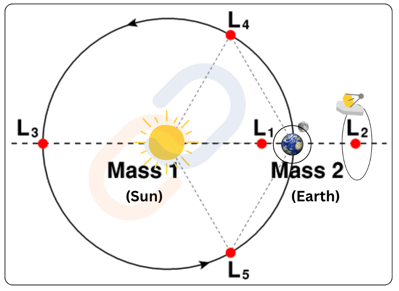
- Altitude: These orbits exist around the Lagrange points of a two-body system (e.g., the Earth-Sun system).
- A Lagrange point is a special spot in space where the gravitational forces of two large objects, like the Earth and the Moon (or the Earth and the Sun), balance out with the centrifugal force felt by a smaller object (like a satellite or spacecraft). This creates a stable location where the smaller object can “hover” or stay in a fixed position relative to the two large objects.
- Five points exist for any pair of orbiting bodies: L1, L2, L3, L4, and L5.
- Points L1, L2, and L3 lie along the line connecting the two large bodies, while L4 and L5 form an equilateral triangle with the two bodies.
- Stability of Lagrange Points:
- L1, L2, and L3 are unstable equilibrium points, meaning any small deviation can cause an object to drift away.
- L4 and L5 are stable equilibrium points, where objects can remain in orbit for long periods without drifting away, making them ideal for satellite placement.
Application:
| LP | Position | Stability | Examples of Use |
| L1 | Between the two large bodies | Unstable | Solar observation. e.g., Aditya L-1, SOHO (Solar and Heliospheric Observatory) |
| L2 | Opposite the smaller body from the first | Unstable | Deep space observatories. e.g., JWST (James Webb Space Telescope)) |
| L3 | On the opposite side of the larger body | Unstable | Not commonly used for spacecraft |
| L4 | 60° ahead of the smaller body in the orbit | Stable | Trojan asteroids in Jupiter’s orbit |
| L5 | 60° behind the smaller body in the orbit | Stable | Trojan asteroids in Jupiter’s orbit |
Halo Orbit:
- A halo orbit is a special type of orbit that occurs around Lagrange points, specifically near the unstable points like L1, L2, and L3. Instead of staying fixed at a Lagrange point, a spacecraft in a halo orbit moves in a three-dimensional, loop-like path around it.
- 3D Shape: Unlike most orbits that lie in a plane (like Earth’s orbit around the Sun), halo orbits are three-dimensional and look like a “halo” or a curved loop around a Lagrange point.
- Gravity Balance: The spacecraft stays in a region where the gravitational forces of two large celestial bodies (e.g., the Earth and the Sun) and the centrifugal force of its motion are balanced.
- Energy Efficiency: Halo orbits are energy-efficient because they take advantage of the gravitational balance at Lagrange points, minimizing the need for frequent propulsion.
Applications:
- Space Observation: Telescopes like the James Webb Space Telescope use a halo orbit around the L2 point of the Earth-Sun system. This position gives them a stable view of deep space while staying away from Earth’s thermal and light interference.
- Note: – Lagrange points like L1 and L2 are unstable, so a spacecraft placed exactly at one would drift away over time. A halo orbit provides stability and keeps the spacecraft near the Lagrange point.
Heliocentric Orbits:
- Satellites that orbit the Sun instead of Earth.
- Examples: Parker Solar Probe, Kepler Space Telescope.
Orbital Decay: Satellites in LEO experience atmospheric drag and gradually lose altitude, eventually burning up on reentry.Kármán Line: The widely recognized boundary of space at an altitude of 100 km above sea level.
Satellite
A satellite is any object that orbits around a larger object due to gravitational forces. Satellites can be natural or artificial, depending on their origin.
| Natural Satellites | Artificial Satellites |
| These are celestial bodies that orbit planets or other larger celestial objects naturally. Example: The Moon (Earth’s natural satellite). | These are human-made objects launched into orbit to serve specific purposes. Example: INSAT-3DR, NavIC satellites, Hubble Space Telescope. |
Types of Satellites Based on Different Criteria
| Category | Type | Range/Characteristics | ISRO Example(s) |
| A) Based on Mass | Large Satellite | >1000 kg | GSAT Series (Communication Satellites) |
| Medium-Sized Satellite | 500–1000 kg | INSAT-3DR (Meteorological Satellite) | |
| Mini Satellite | 100–500 kg | Indian Mini Satellite -1 (IMS-1) – YouthsatIndian Mini Satellite -2 (IMS-2) – SARAL | |
| Micro Satellite | 10–100 kg | Microsat built by ISRO | |
| Nano Satellite | 1–10 kg | India’s first nano satellite, Jugnu: IITK ISRO Nano Satellites – INS-1A and INS-1B | |
| Pico Satellite | <1 kg | Student Satellite (STUDSAT) is the first pico-satellite developed in the country | |
| B) Based on Altitude | Low Earth Orbit (LEO) Satellite | 200–2000 km | Cartosat-2 (Earth Observation) |
| Medium Earth Orbit (MEO) Satellite | 2000–35786 km | NavIC Satellites (Navigation System) | |
| Geostationary Orbit (GEO) Satellite | 35786 km | INSAT-3DR (Meteorological Satellite) | |
| C) Based on Applications | Communication Satellite | GSAT Series (Communication) | |
| Navigation Satellite | NavIC Satellites (Indian Regional Navigation Satellite) | ||
| Remote Sensing or Earth Observation | Cartosat-2, RISAT-1 (Earth Observation) | ||
| Outer Space Exploration or Space Observatory | ASTROSAT (Space Observatory) | ||
How Are Satellites Launched?
- Placement in Rocket: Satellites are placed in the nose cone of a rocket for protection.
- Generating Thrust: The rocket’s engines burn propellants to create enough thrust to overcome gravity.
- Staging: Rockets are launched in stages—empty fuel tanks are discarded to reduce weight.
- Reaching Orbit: The satellite achieves orbital velocity (~28,000 km/h) to balance Earth’s gravity and maintain orbit.
- Deployment: The satellite separates from the rocket and begins its mission.
This process enables satellites to perform tasks like communication, Earth observation, and scientific research, transforming modern life.
What is a Satellite Made Up Of?
Satellites are composed of various subsystems, each designed to perform specific functions crucial to the mission. Here’s a simplified breakdown of these subsystems:
- Payload Subsystem: Carries the instruments needed to fulfill the satellite’s mission.
- Propulsion Subsystem: Changes the satellite’s velocity to adjust its orbit or perform maneuvers.
- Structural and Mechanical Subsystem: Provides strength and shape to withstand vibrations and forces
- Thermal Subsystem: Maintains temperature stability in extreme space conditions.
- Attitude and Orbit Control Subsystem (AOCS): Maintains the satellite’s orientation and corrects its orbit if needed.
- Electrical Power Subsystem : Generates, stores, and distributes power to all satellite systems.
- Telemetry, Tracking, and Command (TTC) Subsystem: Acts as the communication link between the satellite and the ground station.
Communication Satellites
Communication satellites are launched into space to aid long-distance communication and expand network capabilities on Earth. They are used in applications like weather forecasting, navigation, telephone signals, and television broadcasting.
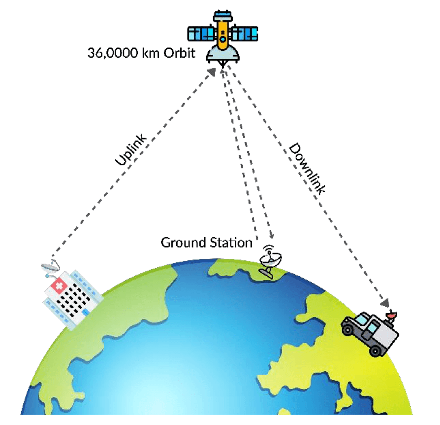
Working of Communication Satellites
- Signal Transmission (Uplink): Signals are sent from an Earth station to the satellite.
- Signal Amplification (Transponder): The satellite receives the signal and boosts it to ensure it’s strong enough for transmission.
- Signal Transmission (Downlink): The satellite retransmits the signal back to Earth.
- Signal Reception: Ground stations or antennas on Earth receive the signal and process it.
Medium of Communication: Communication is carried out through radio or microwave signals.
Orbits of Communication Satellites : The orbit chosen determines the satellite’s coverage area, latency, and applications.
- Geostationary Orbit (GEO): Ideal for television broadcasting, weather monitoring, and long-distance communications. Example: INSAT series (India), Intelsat.
- Medium Earth Orbit (MEO): Used for navigation (e.g., GPS), and some communication systems. Example: O3b (Other 3 Billion) satellite network.
- Low Earth Orbit (LEO): Requires a constellation of satellites for continuous coverage. Example: Starlink (SpaceX), Iridium.
Examples of Communication Satellites
- Indian Satellites: INSAT series , GSAT series (e.g., GSAT-11 for high-speed internet)
- Global Satellites: Intelsat (International Telecommunications Satellite Organization), Starlink (SpaceX’s LEO satellite internet constellation) etc
Uses of Communication Satellites
- Telecommunication: Enable voice, data, TV, and radio services (e.g., INSAT, VSAT).
- Telemedicine: Connect remote areas to hospitals for medical support.
- Tele-education: Provide remote learning through satellites like EDUSAT.
- Banking: Ensure secure ATM and bank connectivity via VPNs.
- 5G Network: Support seamless connections and IoT in remote areas.
- Satellite Internet: LEO satellites provide high-speed, low-latency internet in rural areas.
- IoT Development: Enable autonomous tech and connectivity via small satellites.
- Real-time Tracking: Monitor climate, disasters, and military activities.
- TV and DTH: Broadcast movies, sports, and news via DBS/DTH.
- News Broadcasting: Enable live coverage using OB Vans.
- Radio Broadcasting: Provide clearer audio over large areas.
- Search and Rescue: Assist in saving lives in disasters and remote locations. (Part of the Cospas-Sarsat program)
The Indian National Satellite (INSAT) System
- The Indian National Satellite System (INSAT) is a multipurpose geostationary satellite system developed and launched by ISRO to fulfill the country’s needs for telecommunications, television broadcasting, meteorology, and search-and-rescue operations.
- Transponders: Operate in C, Extended C, and Ku-bands.
Important INSAT Series Developments
- INSAT-1 Series (1982–1990s):
- INSAT-1A: First satellite (1982) but failed to fulfill its mission.
- INSAT-1B: Launched in 1983; operational success.
- INSAT-2 Series (1990s): Expanded services for telecommunications and broadcasting.
- INSAT-3 Series (2000s): Included meteorological imaging capabilities.
- INSAT-4 Series (2000s–present): Dedicated for Direct-to-Home (DTH) television broadcasting and communication.
Transition to GSAT and CMS Series
- GSAT Series: INSAT nomenclature was changed to GSAT for improved services and technology.
- CMS Series: Introduced from 2020 onward for further technological improvements.
| Satellite | Launch Date | Primary Application | Notable Features |
| GSAT-1 | 2001 | Communication satellite | First experimental satellite; failed to achieve target orbit. |
| GSAT-2 | 2003 | Communication satellite | Part of GSLV’s second developmental test flight. |
| GSAT-3 | 2004 | Education (EduSat) | Dedicated to satellite-based distance education. |
| GSAT-4 | 2010 | Communication and Navigation (HealthSat) | Part of GSLV Mk.II’s maiden flight; failed to achieve target orbit. |
| GSAT-7(Rukmini) | 2013 | Military communications (Indian Navy) | First dedicated military communication satellite for the Indian Navy. |
| GSAT-7A(Angry bird) | 2018 | Air-to-air and air-to-ground communication (Indian Air Force) | Enhances network-centric warfare for the Indian Air Force. |
| GSAT-8 | 2011 | Communication and navigation (GAGAN) | Provides high-power transponders for DTH and navigation services. |
| GSAT-9 | 2017 | Regional cooperation (South Asia Satellite) | Promotes regional cooperation by providing telecommunication and broadcasting services to South Asia. |
| GSAT-11 | 2018 | Broadband connectivity | India’s heaviest satellite, enhancing broadband and internet services across rural India and remote regions. |
| GSAT-30 | 2020 | Telecommunication, broadcasting | Replaces INSAT-4A, provides services for DTH, telecommunication, and broadcasting. |
| CMS-01 | 2020 | Communication (Extended-C Band) | Provides services for Indian mainland, Andaman-Nicobar, and Lakshadweep Islands; 42nd communication satellite of India. |
| GSAT-24 | 2022 | Communication, DTH services | 24-Ku band satellite; pan-India coverage for DTH services(Tata Play); first demand-driven satellite mission by NSIL post-space reforms; mission life of 15 years. |
Earth Observation Satellites and Satellite Remote Sensing Technology
Satellite remote sensing is a technology that plays a crucial role in monitoring and observing the Earth’s surface and atmosphere. It has a wide range of applications, such as meteorology, disaster monitoring, land cover classification, and environmental monitoring.
Principles of Satellite Remote Sensing
- Radiation Emission and Reflection: All surfaces emit radiation based on their temperature or reflect incident radiation based on their reflective properties.
- Remote Sensing: In simple terms, remote sensing refers to the collection and recording of information about the emitted or reflected radiation at different wavelengths using onboard satellite sensors. This data helps determine various crucial parameters for different applications.
Components of Remote Sensing:
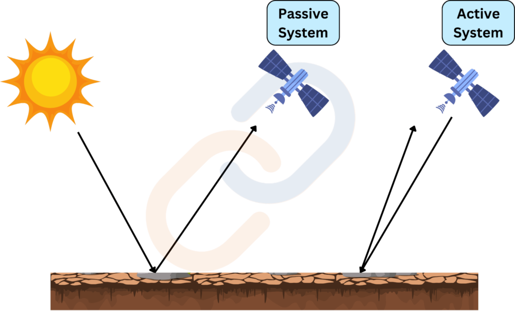
- Energy Source or Illumination: The first step in remote sensing is having an energy source that illuminates or provides electromagnetic energy to the target. Sensors can be classified into two categories based on their energy source:
- Passive Sensors: Detect natural energy (like sunlight) reflected or emitted by objects.
- Active Sensors: Emit their own energy (like RADAR or LIDAR) and measure the reflected energy.
- Interaction with the Target: Energy interacts with the target in different ways:
- Transmission: Energy passes through the object.
- Absorption: Energy is absorbed and turned into heat.
- Emission: The object gives off energy (depending on temperature).
- Scattering: Energy is spread in different directions.
- Reflection: Energy(Radiation) is reflected by the surface, which is the most common interaction for many remote sensing applications.
- Recording of Energy by the Sensor
- The sensor collects and records the energy after it has been scattered, reflected or emitted from the target. Based on EM Spectrum Remote sensing systems are often classified as:
- Optical Remote Sensing: Detects radiation in the visible and infrared regions. ⇒ To study vegetation, water bodies, and Earth imaging.
- Thermal Infrared Remote Sensing: Detects radiation in the mid-wave and long-wave infrared. ⇒ Focuses on measuring surface temperatures
- Microwave Remote Sensing: Includes active sensors like RADAR, capable of observing the Earth in all weather conditions, regardless of day or night.
- The sensor collects and records the energy after it has been scattered, reflected or emitted from the target. Based on EM Spectrum Remote sensing systems are often classified as:
- Transmission, Reception, and Processing: Once the energy is recorded, it is transmitted to Earth-based stations for processing. This often involves converting the data into a digital form, which is then stored and analyzed.
- Interpretation and Analysis: The processed data is analyzed to extract information about the target. This can be done visually or digitally using image processing techniques.
Indian Remote Sensing (IRS) Satellites:
- The Indian Remote Sensing Program began with the Bhaskara-1 satellite (1979) and IRS-1A (1988).
- Orbit: The IRS series of satellites are launched mostly into Low earth and Polar Sun-synchronous orbit.
- Evolution: IRS satellites initially followed the nomenclature of IRS-1A, IRS-1B, etc. Later versions were classified based on their functions, such as Oceansat, Cartosat, HySIS, EMISAT, and ResourceSat. In 2020, the satellites were unified under the prefix EOS (Earth Observation Satellite).
Functional Classes of IRS Satellites:
- IRS-1 Series: Primarily used for natural resource mapping, agriculture monitoring, and environmental studies.
- Oceansat Series: Focused on oceanographic studies.
- Cartosat Series: Specialized in high-resolution Earth imaging for urban planning, infrastructure development, and land mapping. Example: Cartosat-2, Cartosat-3
- HySIS: Aimed at hyperspectral sensing for studying vegetation, urban areas, and land usage.
- RISAT Series: All-weather day-and-night monitoring using radar. Example: RISAT-1, RISAT-2
- ResourceSat: Focused on monitoring natural resources, providing images with higher resolution for mapping land use and water resources. Example: Resourcesat-1, Resourcesat-2
- INSAT Series: GEO satellites used for meteorology and disaster monitoring. Example: INSAT-3DR
- SARAL : Climate & Environment, Earth Observation; Hysis
- NISAR will map the globe in 12 days, offering consistent data for analyzing changes in Earth’s ecosystems, ice mass, vegetation, sea levels, groundwater, and natural hazards.
- EOS series : Designed to provide high-quality images for resource management under all weather conditions.
| Satellite | Launch Year | Specification |
| Bhaskara-I | 1979 | India’s first experimental remote sensing satellite for Earth observation.- Designed for geosynchronous orbit operations. |
| Rohini Satellite RS-D1 | 1981 | Experimental remote sensing satellite.- Launched in low Earth orbit but was only partially successful. |
| HysIS | 2018 | Hyperspectral imaging satellite for Earth observation.- Designed to study Earth’s surface in visible, near-infrared, and shortwave infrared regions. |
| EOS-01 | 2020 | Earth observation satellite for applications in agriculture, forestry, and disaster management.- Delivered high-resolution imagery for operational use. |
| EOS-04 | 2022 | Advanced radar imaging satellite designed for agriculture, forestry, soil moisture, and flood mapping.- Operates under all weather conditions. |
| Oceansat-3 (EOS-06) | 2022 | Third satellite in the Oceansat series.- Enhanced ocean monitoring for parameters like chlorophyll concentration, sea surface temperature, and wind vector. |
| EOS-3 (GISAT-1) | 2021 | First GISAT satellite for civilian applications.- Mission failed due to cryogenic upper stage malfunction.- Designed for near real-time Earth observation. |
| EOS-07 (Microsat-2B) | 2023 | Minisatellite launched during the SSLV-D2 mission (first successful SSLV mission)- Demonstrates quick deployment of new technologies for Earth observation payloads. |
Application of Remote sensing in India (By Isro and other agencies)
- Land Management and Planning: National Land Use/Land Cover mapping on 1:250,000; Re-assessment of basin scale water resources using Space inputs
- Agricultural Planning and Management: Crop Acreage and Production Estimation; Project CHAMAN (Horticulture)
- Forest and Environmental Conservation: Indian Forest Cover Change Alert System (InFCCAS); Study on Sundarban mangrove system; Monitoring and Assessment of ecosystem process in North Western Himalayas
- Water Resource Management: Inventory and Monitoring of Glacial Lakes/Water Bodies; Assessment of Irrigation Potential Utilisation (I.P.U) using geospatial data; Spatial modelling of fluoride contamination in groundwater
- Infrastructure Planning and Management: Monitoring of Gas Pipelines; Island Information System (IIS)
- Climate Change and Disaster Management: Study on Sundarban mangrove system; Monitoring and Assessment of ecosystem process in North Western Himalayas
Remote Sensing in Governance and Policy
- Use of GIS and Remote Sensing in Government Programs:
- MGNREGA (Asset Geo-tagging).
- Digital India (Geo-portal initiatives like Bhuvan).
- Forest Survey of India.
- Role in National Missions:
- Jal Shakti Abhiyan (Water Conservation).
- AMRUT and Smart Cities Mission (Urban Development).
- Soil Health Card Scheme (Soil Mapping).
- Success Stories: Applications in specific Indian states (e.g., Andhra Pradesh’s Land Records Modernization).
- Importance of Bhuvan for governance.
Challenges and Limitations in Remote Sensing
- Technical Challenges: Resolution limitations, data quality, and accuracy issues.
- Policy Constraints: Data accessibility, high costs, and lack of skilled personnel.
- Environmental Concerns: Space debris and satellite sustainability.
- Ethical Concerns: Privacy, surveillance, and misuse of geospatial data.
Future Prospects and Opportunities for India
- Emerging Technologies: Hyperspectral Imaging, LIDAR, UAVs in Remote Sensing.
- Role of Startups: SkyMap Global, SatSure, etc.
- Private Sector Partnerships: Role of IN-SPACe in remote sensing initiatives.
- Vision for the Future: Enhancing India’s role in global geospatial services.
NISAR Mission – NASA-ISRO Synthetic Aperture Radar
- It is a Low Earth Orbit (LEO) observatory jointly developed by NASA and ISRO.
- NISAR will map the entire globe in 12 days.
- Carries L and S dual band Synthetic Aperture Radar (SAR).
- Benefits -Disaster Management, Data for Climate change, earth science, crop growth, soil moisture, and land-use changes, Monitoring of oil spills, urbanization, and deforestation.
National Geospatial Policy 2022 (NGP)
- Released by Department of Science and Technology (DST)
- To expand the access and usage of spatial data, improving citizens services rapidly and increasing its reach to the remotest corners of the country.
Navigation Satellites
- ISRO provides independent satellite-based navigation for civil aviation and general user needs.
- Two major systems:
- GAGAN (GPS Aided GEO Augmented Navigation) – for civil aviation.
- IRNSS (Indian Regional Navigation Satellite System) / NavIC – for national positioning services.
GPS Aided GEO Augmented Navigation (GAGAN)
- Type: Satellite-Based Augmentation System (SBAS).
- Jointly Developed By: ISRO & Airport Authority of India (AAI).
- Objectives:
- High-accuracy satellite-based navigation for civil aviation.
- Better Air Traffic Management over Indian airspace.
- Interoperable with global SBAS for seamless navigation.
- Signal-in-Space (SIS): Provided via GSAT-8 & GSAT-10 satellites.
NavIC/Indian Regional Navigation Satellite System (IRNSS)
- Independent Indian positioning system developed by ISRO.
- Objective:
- Reliable Positioning, Navigation & Timing (PNT) services over India & nearby regions.
- Coverage Area: Includes India and a region up to 1500 km beyond the Indian boundary.
- Provides high-accuracy services for both civilian & strategic applications.
- Reliable Positioning, Navigation & Timing (PNT) services over India & nearby regions.
- Constellation Composition: Consists of 7 satellites and a network of ground stations operating 24 x 7. Three satellites in geostationary orbit and Four satellites in inclined geosynchronous orbit. [Total Built: 9 satellites (8 operational)]
- Operational satellites: IRNSS-1A to IRNSS-1I (except 1H, launch failure in PSLV-39).
- Launch Timeline: 2013–2018.
- Services Offered: provide two types of service
- Standard Positioning Service (SPS) – Open to all users.
- Restricted Service (RS) – Encrypted service for authorized users.
- ISRO launched NVS-01 on board GSLV MK-II in 2023 to augment the NavIC services.
- It has been accepted as a component of the World Wide Radio Navigation System (WWRNS) for operation in the Indian Ocean Region by the International Maritime Organization (IMO).
- This will enable merchant vessels to use IRNSS for obtaining position information similar to GPS and GLONASS to assist in the navigation of ships in ocean waters.
- NavIC to Be Mandatory for Smartphones:
- 5G phones must support NavIC by Jan 1, 2025.
- L1 band phones (currently using GPS) must support NavIC by Dec 2025.
Significance for india:
- Global Recognition: Endorsed by IMO, positioning India as fourth globally to have regional satellite system
- Strategic Autonomy: Reduces reliance on GPS, ensuring independence. (Denial of GPS data during kargil war 1999)
- Socio-Economic Impact:Enables navigation for disaster Management, Vehicle tracking and fleet management, Precise Timing, Mapping and Geodetic data capture etc
- Accuracy and Reliability: NavIC uses dual frequencies (S and L bands) for enhanced accuracy. It offers 5-20 meters precision for general users and 0.5-5 meters for military applications.
- Civil Aviation Support: GAGAN system improves aviation navigation.
- Defense Enhancement: Provides accurate data during hostilities.; Supports modern weapon systems.
- Coverage in Remote Areas: Extends coverage to inaccessible regions by Utilizing high geo-stationary orbit satellites.
- Manufacturing Ecosystem: NavIC-enabled chipsets may become standard in all mobile phones in India, replacing GPS.It will boost the mobile telecom industry and promote adoption across Asia-Pacific.
- Technological Advancement: Introduction of second-generation satellites, such as NVS-01, equipped with Rubidium atomic clocks, showcasing India’s technological prowess in navigation technology.
FAQ (Previous year questions)
Aditya-L1 Mission
India’s first space-based solar observatory, launched on September 2, 2023, via PSLV C57 from Sriharikota.
Successfully placed in a halo orbit around L1 Lagrangian Point for continuous solar observation.
Objectives:
Study solar atmosphere dynamics (chromosphere & corona).
Investigate coronal heating, solar wind, and magnetic field interactions.
Analyze Coronal Mass Ejections (CMEs) and space weather impact (origin, composition and dynamics of solar wind).
24×7 solar observation without eclipse interference.
Key Features:
Aditya – L1 carries 7 payloads (5 by ISRO e.g., SUIT, PAPA, HEL1OS and 2 by Indian Academic institutes)
Captures full-disk UV images of the Sun to understand solar variability & climate impact.
Functions as a space weather station, aiding in geomagnetic storm prediction & satellite protection.
Significance of Aditya-L1 Mission
Expands ISRO’s expertise in solar physics and space astronomy.
Positions India among leading space agencies like NASA, ESA, and CNSA.
Advancement in Space Technology:
Improves space weather prediction for safeguarding satellites and power grids.
Strengthens India’s capabilities in deep-space missions and specialized instrumentation.
Future Solar Exploration: Lays the foundation for future missions like Aditya-L2 (for Sun’s far side imaging) and Aditya-L3 in highly elliptical orbits.
Polar Satellite Launch Vehicle (PSLV)
Third-generation launch vehicle of ISRO
Primarily used for launching remote sensing and Earth observation satellites into Low Earth Orbit (LEO).
Four-stage configuration : 1st & 3rd stage: Solid fuel, 2nd & 4th stage: Liquid fuel
Payload Capacity: Polar Orbit: Up to 1,750 kg
Sub-GTO: Up to 1,425 kg
Known as ISRO’s workhorse
Geosynchronous Satellite Launch Vehicle (GSLV)
Fourth-generation launch vehicle of ISRO
Mainly used for launching communication satellites into higher Earth orbits (GTO – Geostationary Transfer Orbit).
Three-stage configuration : First stage: Solid fuel
Second stage: Liquid fuel (Vikas engine)
Third stage: Cryogenic Upper Stage (CUS)
Payload Capacity: GTO: Up to 4,000 kg,
LEO: 8,000 – 10,000 kg
Known as “Fat Boy”
Indigenization in defence, especially in missile and space technologies, is central to India’s vision of strategic autonomy and technological self-reliance under the Aatmanirbhar Bharat Abhiyan. It reduces dependency on imports and strengthens national security.
Indigenization in defence production
Space technologies
Defence technologies
Launch Vehicles – PSLV, GSLV (Cryogenic technology), NGLV
RLV – TD, CREW Cabin
Satellites – GSAT 7, GSAT 7A (For Military use) etc.
Radars – NISAR, Swathi, Rajendra, Uttam AESA radars etc.
Missile systems – Rudram, Prithvi, Nag etc.
Combat systems – LCA Tejas, Cheetah etc.
Air defence systems – PAD, Akash & Barak-8 Missiles
Drone Warfare and Loitering Munitions – Nagastra-1, D4S System & VajraShot Guns
Command and Control Systems – Integrated Air Command and Control System, Akashteer System, Netra AEW&C etc.
Strategic Importance:
Sovereign Capability: Indigenous missiles like Agni-V and Prithvi bolster nuclear deterrence and second-strike capability.
Strategic Autonomy: Shields India from foreign sanctions and denial regimes like MTCR (Eg. Russia – Cryogenic technology for GSLV).
Enhanced Border Preparedness: Systems like Pinaka, Akash, and S-400 integration improve combat effectiveness.
Global Influence: Export of BrahMos, Pinaka, and satellites promotes India’s strategic footprint.
Technological Importance:
R&D Ecosystem: Agencies like DRDO, ISRO, and startups foster innovation (e.g., scramjet engine, reusable launch vehicles, Hypersonic Technology Demonstrator Vehicle).
Dual-Use Technology: Space and missile tech spin-offs benefit telecom, navigation, disaster management. For example, Satellite tech used in NAVIC (regional navigation), DISHA satellites (weather), and agriculture monitoring.
Customisation: Indigenous systems are suited to local terrain, warfare needs, and climatic conditions.
Cost-Effective Production: Reduces import bills and fosters job creation in high-tech sectors. Example – Launches like PSLV-C37 (104 satellites in one go).
Challenges:
Critical Component Dependency: Kaveri engine project stalled due to lack of indigenous jet engine technology.
Delays in technology transfer and defence procurement.
Project Delays: LCA Tejas and INS Arihant saw long gestation periods.
Private Sector Underutilization: Startups face bureaucratic red tape and limited access to testing facilities.
While significant progress has been made, a holistic approach involving academia, private sector, and policy reform is crucial to transform India into a global defence manufacturing hub.
