
In Indian Geography, the climate and monsoon of India, driven by the southwest and northeast monsoons’ origins, govern rainfall distribution and seasonal patterns. These monsoons, influencing wet summers and dry winters, shape agriculture and ecosystems across regions like the Western Ghats and Gangetic plains.
Previous Year Question
| Year | Question | Marks |
| 2013 | What causes rainy winter and dry summer in Mediterranean climatic region? | 2 M |
| 2016 S. E. | Discuss the impact of La-Nina on Indian Monsoon. | 2 M |
| 2016 S. E. | Describe the ‘Bshw’ type of climate of India. | 2 M |
| 2018 | Discuss orographic impact on rainfall distribution in India. | 5 M |
| 2023 | Write short notes on any two of the following :(a) El-Nino effect on Indian monsoon(b) Indian monsoon and Tibet plateau(c) Western Disturbances in India | 10 M |
General Introduction
- India has a ‘monsoon’ type of climate.
- The word ‘monsoon’ originated from the Arabic word ‘mausim’ [meaning – ‘change of wind direction according to the season’].
- Monsoon winds are actually seasonal winds. They blow from land for six months of the year and from water for the remaining six months. Our country remains under the influence of monsoon winds throughout the year. This is why the Indian climate is called ‘monsoon climate’.
Note- The condition of the atmosphere at a particular time in a limited area is called ‘weather’, while the sum total of weather conditions and variations in a large area and long period of time (30-35 years) is called ‘climate’.
Indian Monsoon
- India’s climate is of ‘warm monsoon’ type.
- The northern part of India which is located north of the Tropic of Cancer comes under the temperate zone, and the part located south of the Tropic of Cancer comes under the tropical zone.
- The Indian monsoon is mainly related to the changes in atmospheric circulation that occur during the summer season.
- With the onset of summer, the Sun begins to move northwards. Along with the Sun’s movement northwards, the Inter Tropical Convergence Zone (ITCZ) also begins to move northwards. Due to its effect, the western jet stream starts flowing north of the Himalayas and due to the high temperature in the Indian subcontinent, low air pressure develops.
- After the western jet stream shifts to the north of the Himalayas, the ‘eastern jet stream’ develops in India. Its position varies according to the seasons in about 15°-30° north latitude, and it is considered to be primarily responsible for the Indian monsoon outbreak.
- Due to the influence of the eastern jet stream, high air pressure develops near the island of Madagascar in the southern Indian Ocean. The south-west monsoon originates from this high pressure centre.
Understanding the Monsoon
- The nature and structure of monsoon is understood on the basis of meteorological data collected from land, oceans and upper atmosphere in different parts of the world.
- The intensity of monsoon can be predicted by measuring the difference in air pressure between Tahiti of French Polynesia located in the eastern Pacific Ocean and Port Darwin located in the eastern part of Australia in the Indian Ocean.
- The India Meteorological Department makes long-term forecasts about the possible behaviour of monsoon on the basis of 16 factors (parameters)
Arrival of Monsoon in India
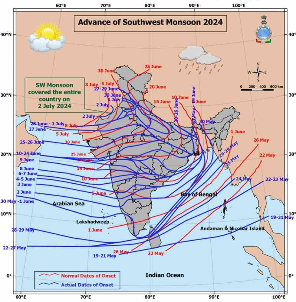
- Monsoon rain in India is seasonal, which mainly occurs during June to September.
- In the first week of June, monsoon winds reach the coastal areas of Kerala, Karnataka, Goa and Maharashtra. First of all, monsoon winds hit the coast of Kerala, which is called ‘Burst of Monsoon’.
- The monsoon reaches the interior parts of the country by the first week of July. The day temperature drops from 50 to 8°C between mid-June and mid-July.
- The distribution of monsoon rainfall is controlled by the topography of India. For example, the windward slopes of the Western Ghats receive heavy rainfall (about 250 cm). Similarly, the hilly topography of eastern India causes heavy rainfall there.
- Monsoon rainfall decreases as the distance from the sea increases. This is the reason why in India, Kolkata receives 119 cm, Patna 105 cm, Allahabad 76 cm and Delhi 56 cm of rainfall during monsoon rains.
- India’s agriculture-based economy is highly dependent on monsoon rains, so when the rains end before the normal time, not only the standing crops are damaged, but sowing of winter crops also becomes difficult.
Origin of Monsoon
- Edmund Halley is the main scientist of classical hypothesis and the scientists associated with modern hypothesis include Flon, M.T. Yin, P Koteswaram, Ramaswamy, Ramamurthy, Pant, Jambunath, Ananthakrishnan, Hamilton, Ramanatham etc.
- Vasant Gowarikar was the first scientist who prepared the Indian model for forecasting monsoon. Hence, he is considered the father of Indian monsoon model.
Theories regarding the origin of Indian monsoon –
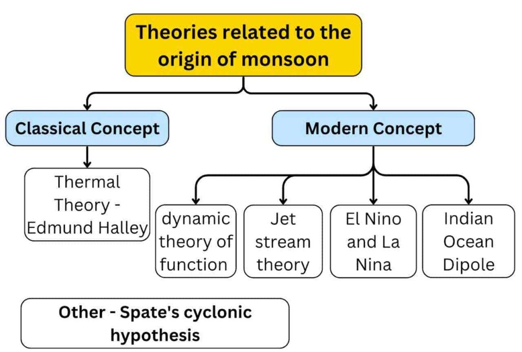
1. Thermal theory or classical theory
- Proponent – ‘Edmund Halley’ [In 1656 for ‘Explaining the Origin of the Asian Monsoon’.]
- The concept is related to the distribution of land and water and their different properties in terms of heat absorption and heat release. Land portions heat up and cool down quickly, while water heats up and cools down late.
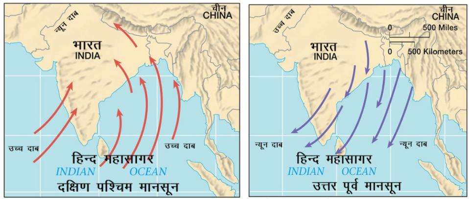
- Due to the sun rays falling perpendicularly on the Tropic of Cancer during summer, a low pressure center develops here and the ‘thermal equator’ shifts towards the north. The south-east trade winds cross the equator being drawn towards the low pressure and turn towards the south-west direction due to the effect of Coriolis force. These winds bring moisture from the sea and bring extensive rainfall in India, which is called south-west monsoon rainfall.
- In winters, due to the land parts getting cold quickly, high pressure is formed there and due to the water areas being relatively warm, low air pressure is formed there. Winds start blowing from land towards water. Due to lack of moisture in these winds, there is lack of rainfall. But due to Coriolis force, when these winds turn to their right and take moisture from the Bay of Bengal, the winds turn to the north-east direction, due to which there is rain on the Tamil Nadu coast (Coromonddal coast). This is called ‘North-East Monsoon Rain’.
- Halley’s theory is unable to explain the complexities of monsoon, such as sudden burst of monsoon, break in monsoon, and its spatial and temporal distribution.
2. Dynamic concept or equatorial westerly wind theory
- Exponent – ‘Flon’.
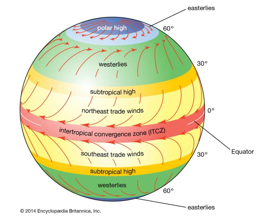
- According to this, due to the northward shift of the thermal equator in summer, the ‘Intertropical Convergence Zone’ (ITCZ) also shifts towards the north. As a result, the (equatorial) westerly winds start influencing the low pressure areas formed on the Indian subcontinent and ultimately the south-west monsoon originates.
- Tropical disturbances are seen to be active along the Northern Intertropical Convergence Zone (NITCZ). They play an important role in affecting the regional weather.
- In winters, when the sun moves south, the low pressure area changes into high pressure. As a result, the north-eastern trade winds become effective again.
|
Intertropical convergence zone-ITCZ |
|
3. Spate’s cyclonic hypothesis
- Australian geographer Spate believes that monsoon winds are the result of the origin of cyclones. These cyclones are formed due to the fronts formed when various air masses meet.
- He believes that the process of formation of fronts is very powerful in summers. Hence these fronts attract rain-bearing winds from the ocean. On the contrary, according to Spate, in winters these fronts are very weak and shallow
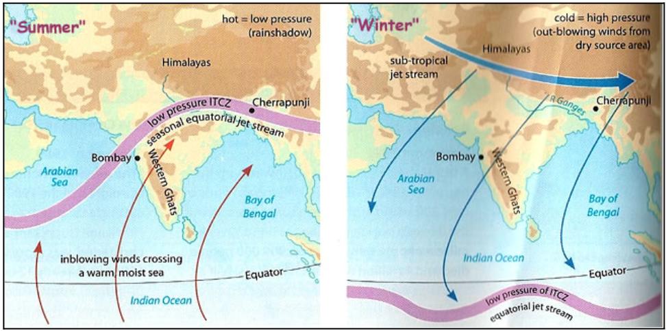
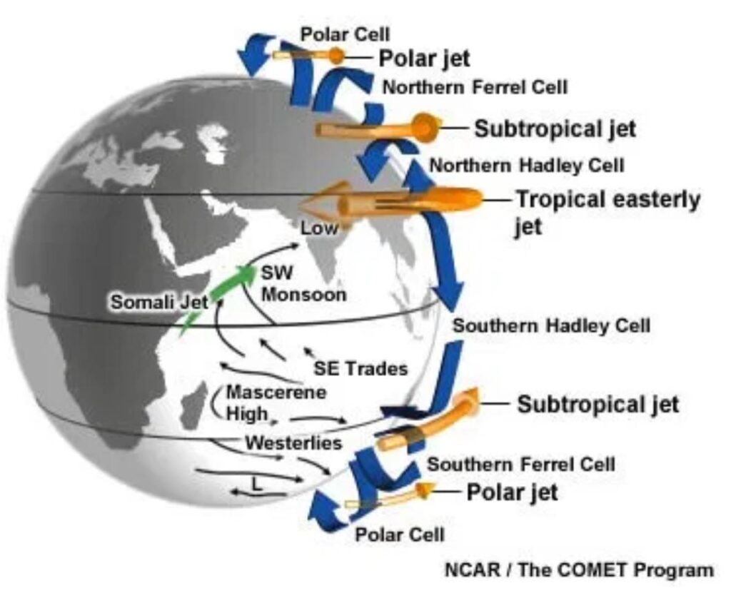
4. Jet Stream Theory
- It is a very fast air flow system in the upper atmosphere, which also affects the weather of the lower atmosphere.
- According to the theory, the ‘tropical easterly jet stream’ causes the origin of the ‘south-west monsoon’ in India and the ‘subtropical westerly jet stream’ helps in the origin of the ‘north-east monsoon’ (winter monsoon).
- In winters the sun moves southwards. As a result all the air pressure belts and corresponding wind belts shift towards the south. The flow of the jet stream also shifts towards the south. The sub-tropical western jet stream (STJ) flows from west to east throughout western and central Asia and when it reaches the Tibetan plateau it gets divided into two branches due to obstruction.
- One branch moves towards the north of the Tibetan Plateau and the other branch moves towards the east towards the south of the Himalayas, which brings ‘Western Disturbance’ to the Indian subcontinent in winter.
- In summer (at the time of the Sun’s Uttarayan), all the temperature zones get displaced towards the north, due to which the ‘subtropical western jet stream’ also gets displaced towards the north of the Tibetan plateau. Due to this, the effect of ‘tropical eastern jet stream’ is created in the upper atmosphere of the Indian subcontinent.
- Tropical Easterly Jet Stream – TEJ- A type of regional and seasonal jet stream which originates from the centre of high air pressure developed in the upper layers of the troposphere due to the ascent of hot air (air getting heated and rising) due to high temperature on the Tibetan plateau during summer.
- The wind blowing from the centre of high air pressure through the Bay of Bengal and the Arabian Sea towards the South Indian Ocean [direction – east to west] is called ‘tropical eastern jet stream’. This air mass reaches the east of Madagascar island in the South Indian Ocean and submerges, due to which strong high pressure is formed there. This high pressure is called Mascarene High.
Note – TEJ is a temporary jet stream that increases the pressure gradient found between the Indian Ocean and the Indian subcontinent. Due to the increase in pressure gradient, the speed of monsoon winds increases which helps in increasing the intensity of monsoon.
- The winds blowing towards the land from this high pressure area flow towards the low-pressure area of northern India. When the south-eastern trade winds blowing from here cross the equator, they turn to the right due to the Coriolis force and hit the coast of the Indian subcontinent and cause rain. These are known as the ‘south-west monsoon’.
|
Somali Jet Stream |
|
It is a jet stream found in the lower atmosphere that blows from the eastern coast of Africa towards the Indian subcontinent. This jet strengthens the permanent high pressure area near Madagascar and helps the southwest monsoon to advance towards India with faster speed and intensity. |
|
Role of Tibet Plateau |
|
5. El Niño and La Niña Hypothesis
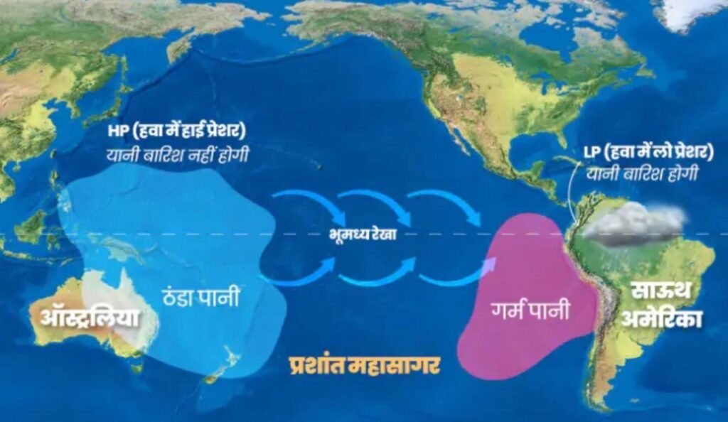
Normal Conditions
- Generally, the cold Peru Current is found in the eastern part of the South Pacific Ocean and the warm East Australian Current is found in the western part, due to which high pressure conditions are found near the coast of Peru and low pressure conditions are found near the eastern coast of Australia. Hence, rainfall is received due to convection of air near the coast of Australia and dry conditions are created near the coast of Peru due to subsidence of air.
- Due to the difference in pressure found in the eastern and western parts of the South Pacific Ocean, atmospheric circulation takes place between these parts, which is called Walker Cycle. Under normal conditions, the direction of the Walker Cycle is clockwise.
El Nino and the Indian Monsoon
- This is a complex weather system, due to which drought, floods and extreme weather conditions occur in different parts of the world.
- Meaning of El Niño – ‘Child Jesus’ [The current appears in December around Christmas.
- This system includes oceanic and atmospheric phenomena. El Niño is a warm ocean current formed in the eastern Pacific Ocean every 2 to 5 years, which comes and gets established in place of the cold Peru Current / Humboldt Current. This current increases the temperature of the water of the Peru coast by 10°C. It has the following consequences-
- Distortion in the equatorial atmospheric circulation
- Irregularity in the evaporation of sea water
- Decrease in the amount of plankton, which leads to decrease in the number of fish in the sea.
- Due to the formation of low air pressure, the force (Push Factor) pushing the south-eastern trade winds from here becomes weak. Instead, the force (Pull Factor) attracting or pulling the trade winds becomes effective here. Due to this, the flow of these trade winds towards Asia also weakens. As a result, there are chances of the summer monsoon arriving late and weakening in India.
Note –During El Niño, the pressure conditions in the South Pacific Ocean change completely. Low pressure conditions are found near the coast of Peru and high pressure conditions are found near the eastern coast of Australia. As a result, the direction of the Walker Cycle changes to anticlockwise. This change in the direction of the Walker Cycle is called El Niño Southern Oscillation.
- The intensity of monsoon is known on the basis of pressure of Tahiti and Darwin. Under the Southern Oscillation Index, the pressure of Darwin is subtracted from the pressure of Tahiti. If the answer is negative, then it indicates delay in monsoon, less rainfall and El Nino conditions. If the answer is positive, then it indicates normal conditions and heavy rainfall.
El Niño effect
Mechanisms of the La Nina effect
- This is a Spanish word, which means The Little Girl.
- During La Niña, a colder current than normal comes and gets established in place of Peru Current.
- When the temperature near the Peru coast in the South Pacific Ocean falls below normal, air pressure develops more than normal. Due to this, the force pushing the winds from here becomes strong. As a result, there are chances of early arrival and strong monsoon in India.
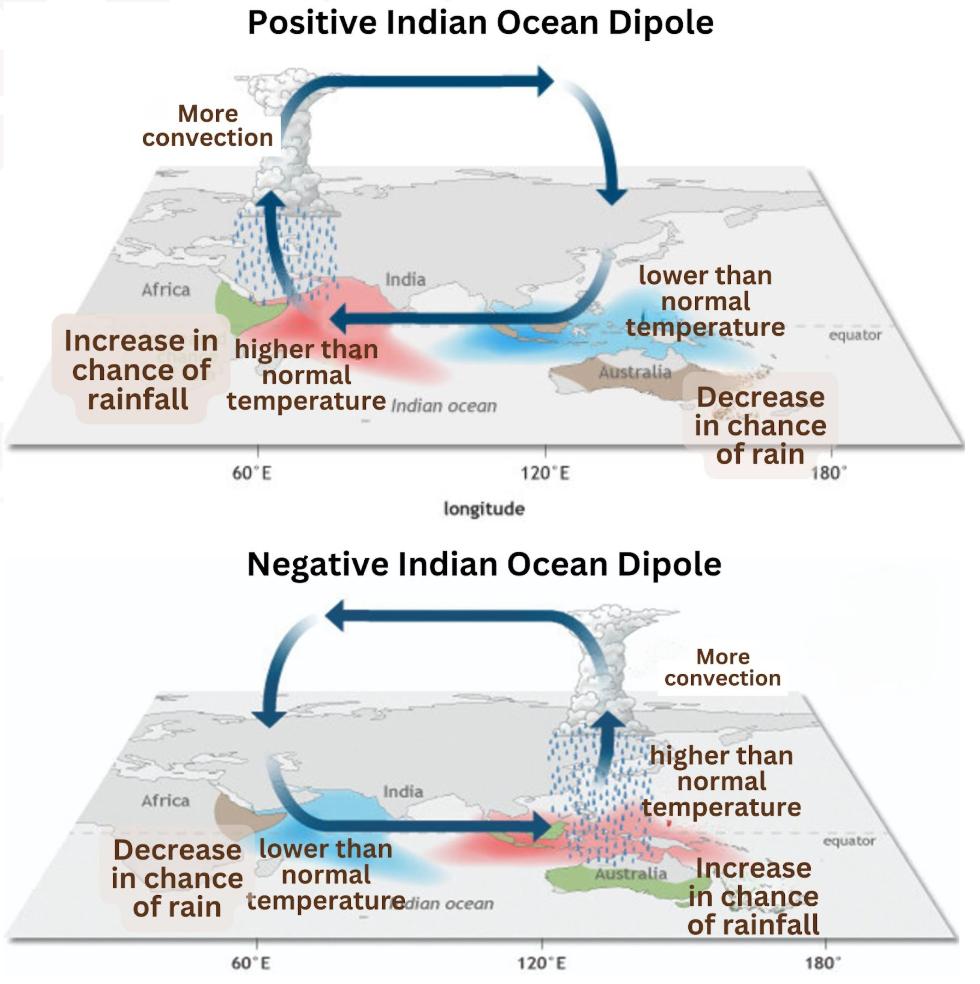
6. Indian Ocean Dipole and Indian Monsoon
- During summer, different thermal conditions arise in two different areas on the water surface of the Indian Ocean, which is called the Indian Ocean Dipole.
- This affects El Niño, which affects the Indian monsoon.
- The Indian Ocean Dipole is mainly of two types-
- Positive Indian Ocean Dipole – In this situation, the temperature of the tropical western Indian Ocean (Arabian Sea) is higher than the normal temperature of the eastern Indian Ocean. This creates favourable conditions for the Indian monsoon.
- Negative Indian Ocean Dipole – In this situation, the temperature of the tropical western Indian Ocean is lower than the normal temperature and the temperature of the tropical eastern Indian Ocean is higher than the normal temperature. This creates unfavourable conditions for the Indian monsoon.
Gap of Monsoon
- If after continuous rainfall during the monsoon period, the rainfall stops for a few weeks, then such a situation is called ‘Monsoon break’.
- Different factors are responsible for this break in different regions of India, such as-
- On the western coast, moist winds flow parallel to the coast.
- Therefore, there is a change in the tropical convergence zone in the plains of North India and a decrease in the number of tropical cyclones.
- In Rajasthan, due to the effect of thermal inversion in the lower layers of the atmosphere, there is an obstruction in the ascent of moist air.
Retreating Monsoon
- The process of the return of monsoon in October-November is called the retreat of monsoon.
- At the end of September, due to the southward movement of the Sun, the low pressure belt formed on the Gangetic plain starts shifting towards the south, due to which the south-west monsoon weakens and by the middle of December, the centre of low pressure completely moves away from the Indian subcontinent.
- During the retreat, the sky is clear and the temperature rises, causing a sultry summer (“Kartik month’s heat”).
- North India remains dry, while the eastern coasts of peninsular India (especially the Coromandel coast) receive rainfall from cyclonic depressions and tropical cyclones generated in the Andaman Sea. Some cyclones also hit the coasts of West Bengal, Bangladesh and Myanmar. Such cyclones rarely occur in the Arabian Sea.
Characteristics of monsoon rainfall in India
- Monsoon rainfall is seasonal, occurring mainly in summer.
- The southwest monsoon winds change direction as they reach the land mass due to relief and pressure conditions.
- The rainfall begins suddenly with thunder and lightning, called the “monsoon burst”.
- The rainfall occurs in moist spells, with dry intervals, called “monsoon breaks”, in between.
- The amount of rainfall decreases as the distance from the coast increases.
- The distribution of monsoon rainfall is uneven; some areas receive as little as 12 cm, while some receive more than 250 cm.
- The monsoon rainfall is erratic – sometimes it starts early, sometimes late, and sometimes its end or quantity also changes.
Factors Affecting the Indian Monsoon
- The presence of a high pressure area is found over the Indian Ocean at about 20° south latitude, i.e., east of Madagascar. The intensity and location of this high pressure area affects the Indian monsoon.
- The Tibetan plateau becomes very hot in summer, due to which strong vertical wind currents are generated and a low pressure area is formed over the surface of the Tibetan plateau.
- The displacement of the western jet stream northwards over the Himalayas and the presence of the tropical easterly jet stream over the Indian peninsula during summer also affect the Indian monsoon.
- Changes in pressure conditions over the southern oceans also affect the monsoon.
- The monsoon is affected positively/negatively due to the El Niño Southern Oscillation (ENSO)
Monsoon and economic life of India
- Monsoon is central to India’s life cycle, as 64% of the population depends on agriculture, which is mainly driven by the southwest monsoon.
- Except in the Himalayas, the rest of India has year-round heat, making continuous farming possible.
- The diversity of the monsoon climate encourages the cultivation of a variety of crops.
- The uncertainty of rainfall causes problems such as drought and floods.
- The prosperity of agriculture depends on the timing and proper distribution of monsoon, especially in areas without irrigation.
- The intense impact of monsoon causes problems like soil erosion.
- The rainfall from winter cyclones in North India is beneficial for Rabi crops.
- The diversity of climate reflects the diversity in food, clothing and housing.
Indian Climate
Keeping in mind the monsoon period, the Meteorological Department of the Government of India has divided the year into the following seasons –
(अ) North-east or winter monsoon season-
- Winter season – December to February.
- Summer season – March to mid June.
(ब) South-westerly or summer monsoon period –
- Rainy season – from mid June to mid September.
- Autumn season – from mid September to December.
Traditional Seasons of India
| Season (ऋतु) | Months (Indian Calendar) | Months (Gregorian Calendar) |
| Spring (Vasant) | Chaitra – Baisakh | March – April |
| Summer (Grishma) | Jyeshtha – Ashadha | May – June |
| Monsoon (Varsha) | Shravan – Bhadrapada | July – August |
| Autumn (Sharad) | Ashwin – Kartik | September – October |
| Pre-Winter (Hemant) | Margashirsha – Paush | November – December |
| Winter (Shishir) | Magha – Phalguna | January – February |
1. Summer Season
- Temperature – With the displacement of the sun rays towards the Tropic of Cancer in March, the temperature in North India starts increasing, due to which summer is clearly experienced in North India in the months of April, May and June.
- During summer, the temperature in most parts of India ranges from about 30°C to 32°C, while in the month of May, due to the northward shift of the heat belt, it is common for the temperature in the north-western parts to reach 48°C.
- Owing to the moderating effect of the sea on peninsular India, even in summers the temperature of South India remains lower than that prevailing in North India. Thus, summers in South India are mild, with temperatures ranging from about 26°C to 32°C.
- The hottest place in India during summers is Briavali (Bikaner) / Phalodi, Rajasthan.
- Air pressure and winds – In summer, the air pressure in northern India falls due to extreme heat. By July, the Intertropical Convergence Zone (ITCZ) shifts northwards to about 25°N latitude. This region extends from the Thar Desert to Patna and Chhattisgarh plateau as a low pressure monsoon trough, which attracts surface circulation of winds.
- The southwest monsoon winds blow in a southwesterly direction over the west coast, West Bengal and Bangladesh, while over northern Bengal and Bihar they are easterly and south-easterly. These winds are displaced equatorial easterly winds, the ingress of these winds by mid-June changes the weather to the rainy season.
- The hot or dry winds blowing in the centre of this low pressure before the arrival of the southwest monsoon winds are called ‘loo’ in Rajasthan, Uttar Pradesh and Bihar. During this time, heavy rain storms like Kal Baisakhi, Bodoichila and Norwester blow in West Bengal, Assam and Orissa respectively.
|
Some famous local storms that occur during summer |
Whenever the air in the centre of low pressure rises due to regional effect, then ‘convective rain’ occurs in a limited area and for a short time at a fast speed along with thunder. This type of rain is called ‘Mango rain’ (helps in early ripening of mangoes) in Kerala and ‘Cherry blossom’ in Karnataka. This happens at the end of summer. |
2. Rainy Season
- Between June and September, India receives ‘monsoon rainfall’ due to the southwest monsoon winds.
- The southwest monsoon winds collide with the southern tip of peninsular India and get divided into two branches,-
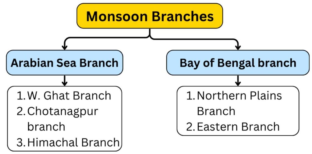
- ‘Arabian Sea Branch’ – it splits into three subbranches.
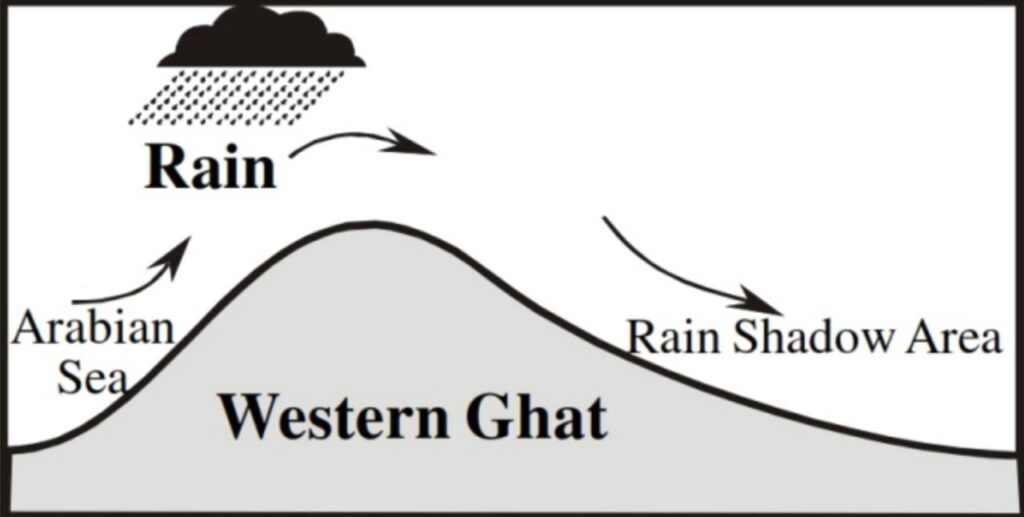
- Western Ghats Branch – This branch after hitting the western slope of the Western Ghats climbs up to a height of 900 – 1200 m and after cooling down, this branch forms clouds and this region receives more than 200 cm of rainfall. It causes less rainfall on the eastern slope of the Western Ghats and becomes hot while descending from the eastern slope. This region of less rainfall is called the rain-shadow region.
- Chotanagpur Branch – Chotanagpur branch moves from the Narmada and Tapi river valleys towards the Chotanagpur plateau, where it enters the Gangetic plains and merges with the monsoon branch coming from the Bay of Bengal.
- Himachal Branch – hits Saurashtra peninsula and Kutch. From there it goes directly towards the low centre plains of Punjab and Haryana parallel to Aravali mountain without rain or raining very little. In Punjab-Haryana it meets the monsoon branch of Bay of Bengal. Both these branches are strengthened by each other and bring rain in Western Himalayas especially in Dharamshala
- Bay of Bengal branch – This branch gets deflected towards India after hitting the Arakanyoma Mountains. This branch enters India from the south-eastern direction. After entering West Bengal, it gets divided into two branches under the influence of the Himalayan Mountains and the thermal low pressure in the north-west of India –
- Northern Plains Branch – This branch is attracted towards the low pressure centre formed in north-western India. It brings rain in the plains of Ganga and in eastern Rajasthan. In Bihar it meets the Chota Nagpur branch and in Punjab, Haryana it meets the Himachal branch.
- Eastern Branch – It rises in the Brahmaputra valley in the north and north-east. This branch brings rain in vast areas there. One of its sub-branches collides with the Garo and Khasi hills situated in Meghalaya. Mawsynram situated on the peak of the Khasi hills receives the highest average annual rainfall in the world.
- The Coromandel coastal region does not receive rainfall in this season because-
- The Tamil Nadu coast lies parallel to the monsoon winds of the Bay of Bengal.
- It lies in the rain-shadow region of the Arabian Sea branch of the south-west monsoon.
- There is no monsoon rainfall during summer in the Aravalli mountainous region and the Coromandel coastal region of Tamil Nadu due to the parallel flow of the south-west monsoon winds.
- The lowest rainfall in India occurs in ‘Leh’
|
Ratio of rainfall in India |
|
| Distribution of Rain | |||
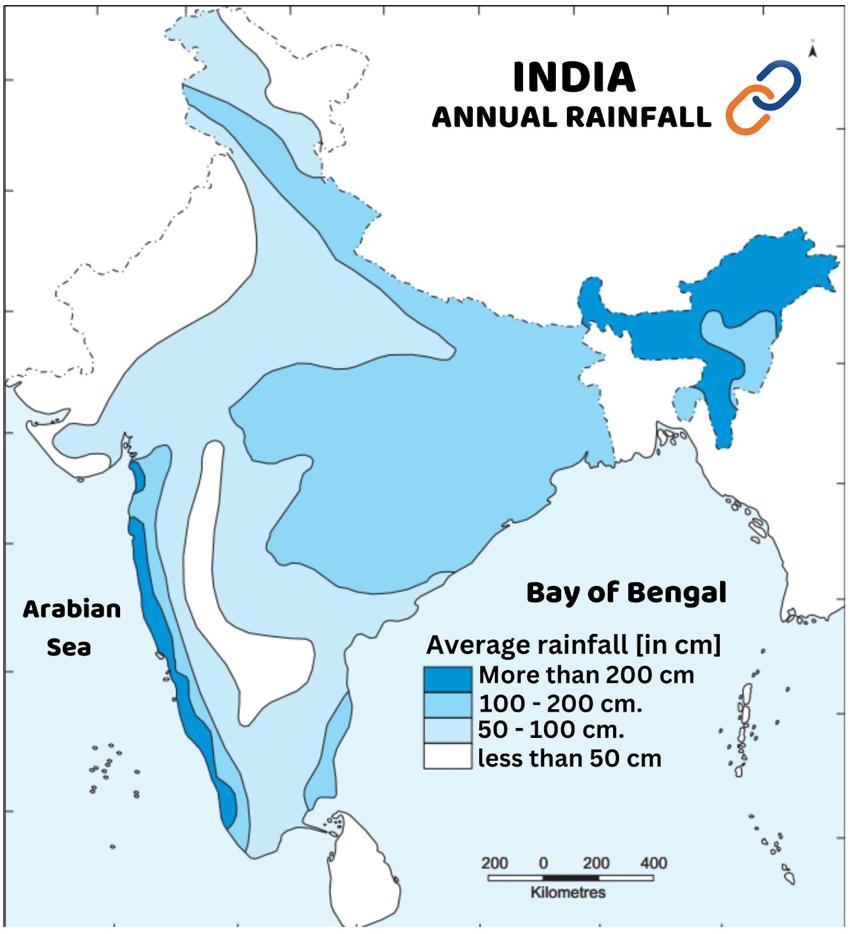
| The average annual rainfall in India is about 125 cm. But there are regional variations in this. | |||
| Classification | Rainfall | Area | |
| high rainfall areas | More than 200 cm | Western Ghats, Goa, Karnataka, coastal areas of Kerala, Sub-Himalayan region of the North-East, Hills of Meghalaya, like Khasi and parts of Jaintia Hills [Cherrapunji and Mawsynram], Andaman and Nicobar Islands, Lakshadweep. | |
| Areas with moderate rainfall | 100 to 200 cm. | Eastern part of the Western Ghats, Eastern Tamil Nadu, Southern part of Gujarat, North-eastern Peninsula including Odisha, Bihar, Jharkhand, Eastern Madhya Pradesh, Northern Gangetic plains adjoining the Sub-Himalayas, Cachar Valley and Manipur. | |
| areas with low rainfall | 50 to 100 cm. | Delhi, Haryana, Punjab, Jammu and Kashmir, Eastern Rajasthan, Western Uttar Pradesh and Deccan Plateau. | |
| Areas with insufficient rainfall | less than 50 cm rainfall | Most parts of Ladakh and western Rajasthan, some areas of Telangana, Andhra Pradesh, Karnataka and Maharashtra. | |
3. Autumn Season
- Between September and December, due to the southward movement of the Sun, the temperature of the Indian subcontinent keeps decreasing and the pressure keeps increasing. Due to this, the monsoon winds start returning from the middle of September due to the development of a high pressure center in the plains of Punjab and Haryana. This is called the ‘return of the monsoon’ or ‘withdrawal of the monsoon’.
- During this time, along with the temperature zones, the ‘Monsoon Trough’ (ITCZ) also gets displaced towards the south, due to which the ‘Subtropical Western Jet Stream’ starts displacing from the Tibetan Plateau towards the Himalayas and the effect of the ‘Tropical Eastern Jet Stream’ on the Indian Peninsula starts reducing, due to which favourable conditions are created for the origin of tropical cyclones in the Bay of Bengal.
4. Winter Season
- Winter in North India generally begins in mid-November [January and February are the coldest months].
- Temperature – Temperature increases from north to south. The average temperature in northern India is 8°C to 21°C and in southern India it is 21°C to 26°C. The night temperature is much lower than that of the day and falls below freezing point (0°C) in Punjab and Rajasthan.
- The coldest place in India during winter is Drass (Ladakh).
- There are mainly three reasons for extreme cold in North India during winters-
- States like Rajasthan, Punjab and Haryana are affected by continental climate due to their location away from the moderating effect of the sea.
- Cold wave conditions arise due to proximity to the Himalayas and snowfall in its ranges.
- Cold winds from the Caspian Sea and Turkmenistan bring cold waves. As a result, along with a decrease in temperature in the north-western parts, frost and fog also occur.
- Due to the moderating effect of the sea and its proximity to the equator, peninsular India does not have a distinct winter season as seen in North India.
- Air pressure – In winter, high air pressure develops over the land due to the fall in temperature in the Indian subcontinent. The highest air pressure centers in the Asian continent are located near Lake Baikal, near Peshawar in Pakistan and in north-western Rajasthan. At the same time, the Indian Ocean remains relatively warm, due to which low air pressure is formed there.
- Winds – Around 22 December the sun shines directly on the Tropic of Capricorn, leading to weak high pressure over the northern plains and relatively low pressure over southern India. The isobars of 1,019 millibars and 1,013 millibars pass through northwest India and the far south respectively. Slow (3-5 km/hr) winds blow from the northwest high pressure towards the low pressure area of the Indian Ocean. The topography also influences their direction—the flow is westerly or northwesterly in the Ganga valley, northern in the Ganga-Brahmaputra delta, and distinctly northeasterly in the Bay of Bengal. These winds are known as the north-east monsoon.
- Rainfall – The winter monsoon winds are dry as they flow from land to sea. Friction on land raises their temperature, which causes them to lack moisture and produce no rainfall. As a result, most of India does not receive rainfall during winter. However, winter rainfall is observed in some exceptional areas.
- Central India and northern parts of the southern peninsula occasionally receive winter rainfall.
- Arunachal Pradesh and Assam receive 25–50 mm of rainfall during winter.
- The northeast monsoon winds bring moisture from the Bay of Bengal in October–November and bring heavy rainfall over Tamil Nadu (Coromonddal), south Andhra Pradesh, southeast Karnataka and southeast Kerala.
- In north-west India, temperate cyclones coming from the Mediterranean Sea bring light rains in Punjab, Haryana, Delhi and western Uttar Pradesh. This winter rain is very useful for the Rabi crop. In the lesser Himalayas, this rain occurs in the form of snow, which maintains the water flow of Himalayan rivers in summer. The amount of rain in the plains decreases from west to east and in the mountainous regions from north to south. For example, the average winter rainfall in Delhi is 53 mm, while between Punjab and Bihar it is limited to 18-25 mm.
|
Western Disturbance |
Note – Between December and March, the Sun remains in the southward motion, due to which a high pressure area develops in north-west India and the ‘Subtropical Western Jet Storm’ expands in the northern plains of India, due to whose effect, heavy rainfall occurs in the form of ‘Western Disturbance’ in the north-western states of India, in a short duration and in limited areas. |
Climate and Monsoon / Climate and Monsoon / Climate and Monsoon / Climate and Monsoon / Climate and Monsoon / Climate and Monsoon / Climate and Monsoon / Climate and Monsoon / Climate and Monsoon / Climate and Monsoon / Climate and Monsoon / Climate and Monsoon / Climate and Monsoon / Climate and Monsoon / Climate and Monsoon / Climate and Monsoon / Climate and Monsoon / Climate and Monsoon / Climate and Monsoon / Climate and Monsoon / Climate and Monsoon .Climate and Monsoon Climate and Monsoon
