
In the study of Indian Geography, major rivers play a vital role in shaping the country’s landscape, culture, and economy. These rivers, such as the Ganges, Brahmaputra, and Indus, are lifelines for millions, supporting agriculture, transportation, and spiritual traditions across the subcontinent.
Previous Year Question
Year | Question | Marks |
2024 | Explain the difference between the Himalayan and the Peninsular Rivers under the following heads: Place of Origin, Nature of Flow, Type of Drainage, Nature of River and Catchment Area. | 10 M |
2023 | Name any 8 tributaries of river Krishna. | 2 M |
- When the water of rivers flows through certain waterways (channels), it is called ‘drainage’ of the rivers and the network of these channels is called ‘drainage system’.
- The drainage system is an integrated system of the main river and tributaries, which collects surface water and gives it direction.
- ‘Drainage basin’ – the area drained by a river and its tributaries
- A river brings its water from a specific area, which is called the ‘catchment area’.
Drainage Pattern of Rivers
‘Drainage Pattern’ – The formation made by the river and its tributaries from the source of the river to its mouth.
The drainage of rivers depends on the following factors-
- Geological time period
- Nature and structure of rocks
- Topography
- Slope gradient
- Amount of water
- Duration of flow
Rivers have various drainage patterns –
- Dendritic Drainage Pattern – When the streams of water in rivers flow according to the land slope of that place, then a drainage pattern like the branches of a tree is formed by the main river and its tributaries, for example – rivers of the plains of North India and the east flowing rivers of South India, such as Ganga, Yamuna, Godavari, Krishna, Kaveri etc.
- Trellis Drainage Pattern- When the main rivers flow parallel to each other and the tributaries join them at right angles.
- Rectangular Drainage Pattern – When tributary rivers meet their main river at right angles. Example- Some rivers of Vindhya hills and Palamu region form this type of drainage pattern.
- Radial Drainage Pattern – When water streams flow in all directions from a central peak. Example- Rivers originating from Amarkantak hill, Narmada and Son flow in different directions
- Annular Drainage Pattern – The subsequent rivers pass through a curved or arced path before joining the next river, which creates a ‘ring pattern’. This drainage pattern is not generally developed in India. Some examples of this are found in the rivers of Nilgiri (Tamil Nadu) and Pithoragarh (Uttarakhand) mountains.
- Centripetal drainage pattern – When rivers flow from all directions and discharge into a lake or basin.
- Dome-shaped drainage pattern – It is a combination of the elements of annular and radial drainage systems.
- Parallel drainage pattern – In this drainage pattern, rivers flow almost parallel to each other. Rivers originating from the Western Ghats and meeting the Arabian Sea are examples of this.
Drainage System – On the basis of the nature of the initial surface, slope and geological structure, the drainage system is divided into two parts-
- Sequential Drainage System – This includes those rivers which flow according to the slopes, such as consequent, subsequent rivers etc.
- Consequent rivers – Those rivers which flow in the direction of general slope. Most of the rivers of peninsular India are examples of consequent rivers.
- Subsequent rivers – Rivers which meet the main consequent river at right angles. For example, Chambal, Sindh, Betwa, Son etc. rivers meet Ganga and Yamuna at right angles.
- Insequent system– It includes those rivers which do not follow the regional slope and flow against the geological structure, such as antecedent and pre-planted rivers.
- Antecedent rivers – Those rivers which were flowing before the formation of Himalayas and flow by cutting the elevated places like mountains in the direction of their streams and forming gorges. Example- Indus, Brahmaputra, Sutlej etc. are antecedent rivers.
- Superimposed Rivers- These rivers do not follow the slope of the land mass. Swarnarekha, Son, Chambal, Banas etc. are examples of superimposed rivers.
Drainage system of rivers of India
On the basis of geographical shapes, the drainage system of Indian rivers has been mainly divided into two categories-
- Drainage system of Himalayan rivers
- Drainage system of Peninsular rivers
Drainage system of Himalayan rivers
- The rivers originating from the Himalayas are perennial, they get water from both ‘melting of snow’ and rainfall.
- On their mountainous route, these rivers form deep gorges, V-shaped valleys, rapids and waterfalls and on reaching the plains, they form flat valleys, oxbow lakes, flood plains, meanders and deltas.
The drainage system of the rivers originating from the Himalayas mainly includes the drainage system of three rivers-
- Indus River Drainage System
- Ganga River Drainage System
- Brahmaputra River Drainage System
Indus River Drainage System
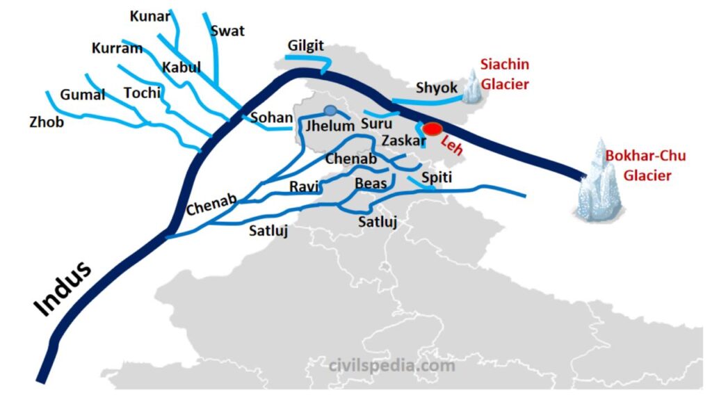
Indus
- Length- 2880 km (1,114 km in India)
- Catchment Area- 11.65 lakh km and 3.21 lakh sq km in India
- Origin- Bokhar Chu Glacier (northern slope of Mount Kailash) near Mansarovar Lake.
- Falls in – Arabian Sea near Karachi
- Drainage Area- Tibet (China) ➔ Ladakh ➔ Pakistan.
- Tributaries- Kishanganga, Shyok, Hunza, Kurram, Tochi, Shigar, Nubra, Gilgit, Swat, Kabul, Gomal from right side and Jhelum, Chenab, Ravi, Beas, Sutlej, Jaskar, Dras, Suru from left side.
- Characteristics –
- The Indus River enters India at Demchok, then after cutting through the Ladakh range from north to south at a place called Dungti, it flows in a northwest direction between the Ladakh and Jaskar ranges.
- While flowing through Ladakh and Gilgit, it forms a gorge and enters Pakistan near Chilas in Dardistan.
- Near Leh, the river Jaskar joins it from the left. A little ahead of this confluence, the Nimmo Bajgo hydroelectric project is being run near Alchi on the Indus River.
- At a place called Buji, north of Nanga Parbat, a 5181/5200 m deep gorge is formed in the Himalayas.
- It enters the plains from a place called Attock in Pakistan.
- Indus is an eastern river.
- It is called ‘Singi Khamban’ / ‘Lion’s mouth’ in Tibet.
- Panchmahanad – Five major rivers joining Indus from the left side – from north to south
- Jhelum/Vitasta
- Chenab/Askini
- Ravi/Parushni/Iravati
- Beas/Bipasha/Argikiya
- Sutlej/Samudri/Satadru
- The Panchnad rivers join together and merge into the Indus River near ‘Mithankot’ in Pakistan.
- Leh is situated on the right bank of the Indus River.
- According to the Indus River Water Treaty (1960), India can use only 20% of its discharge capacity.
Jhelum –
- Length – 724 km (400 km in India)
- Origin – From ‘Sheshnag Lake’ near Verinag situated in the foothills of Pir Panjal range
- Falls in – Meets Chenab at Trimu place in Jhang district of Punjab (Pakistan)
- Drainage area – Jammu and Kashmir
- Tributaries – Kishanganga (Neelam) from the right
- Flows in the north-west direction and passes through Wular Lake.
- Wular Lake –
- It is the largest freshwater lake in India located in Jammu and Kashmir.
- Example of tectonic lake
- Natural lake
- In Jammu and Kashmir, the Jhelum river flows from Muzaffarabad to Mirpur (India and Pakistan) along the border.
- It flows through Srinagar.
- Jhelum is navigable from Anantnag to Baramulla in Kashmir.
- Formation of meander near Srinagar.
- Before entering Pakistan, this river forms a deep valley, which is known as ‘Basmangal’.
- Projects- Uri and Tulbul are in Jammu and Kashmir and Mangla Dam is in Pakistan.
Chenab –
- Length – It is the largest tributary of Indus (length in India is 1,180 km).
- Origin – From the confluence of Chandra and Bhaga streams near Baralacha Pass [Himachal Pradesh]
- Falls in – in Indus river at Mithankot in Pakistan.
- Drainage area – From Himachal Pradesh to Jammu and Kashmir
- Tributary rivers – Jhelum (from the right), Ravi and Sutlej from the left
- In Himachal Pradesh, the Chandra river originates from a glacier and the Bhaga river originates from a spring on a steep slope. Chandra and Bhaga merge at a place called Tandi near Kalong.
- It flows in the west direction for some distance parallel to the Pir Panjal mountain range and forms a deep gorge in Pir Panjal near Kishtwar. After this, it enters the plains near Akhnoor.
- It is the largest (water volume) river of the Indus river system.
- Projects–
- Dulhasti, Salal, Baglihar in Jammu and Kashmir.
- Pakal Dul Hydroelectric Project proposed on Marusudar River, a tributary of Chenab in Jammu and Kashmir.
- The world’s highest railway bridge is built on the Chenab River in Reasi district of Jammu and Kashmir state.
Ravi –
- 725 km in India
- Origin – Barabhangal village near Rohtang Pass of Lesser/Greater Himalayas in Himachal Pradesh.
- Falls in – In the Chenab River near Sarai Sindhu in Pakistan
- Drainage area – Himachal Pradesh, Jammu and Kashmir, Punjab.
- Ravi drains the western slopes of Pir Panjal and northern slopes of Dhauldhar range.
- Flows through Chamba valley of Himachal Pradesh.
- Passes through gorge in Dhauldhar range and enters plains of Punjab.
- Enters Pakistan forming India-Pakistan border.
- Lahore (Pakistan) is on its bank.
- 1929 Lahore session on the bank of river Ravi.
- Projects–
- Chamera Dam [Himachal Pradesh].
- Thein (Ranjit/Ranjit Sagar) Dam in Punjab.
- Shahpurkandi Dam Project in Punjab.
Beas –
- Length – 465 km.
- Origin – From Vyas Kund near Rohtang Pass [Himachal Pradesh].
- Falls in – In the Sutlej river at Harike place in Punjab.
- Drainage area – Himachal Pradesh, Punjab.
- Flows through Kullu Kangra Valley forming a deep gorge [at Kati and Largi] in the Dhauladhar range.
- Enters the plains at a place called Talwara in Hoshiarpur district of Punjab.
- The only river of Panchanad which flows only in India.
- Indus Dolphins are found in Vyas River.
- Projects –
- Pong Dam Kangra [Himachal Pradesh] is built from Maharana Pratap Sagar Reservoir.
- Pandoh Dam [Himachal Pradesh].
- Harike Barrage – Located at the confluence of Sutlej and Beas and Indira Gandhi Canal Project [Rajasthan Canal] was taken out from here.
Sutlej River –
- Length – 1450 km (1,050 km in India).
- Origin – From Rakshastal Lake, south of Mount Kailash in Tibet. Where it is known as ‘Longchen Khambab’.
- Falls in – In the Chenab River near the town of Uch Sharif in Bahawalpur [Punjab, Pak]
- Drainage area – Himachal Pradesh, Punjab.
- Tributaries – Beas (right) Spiti (left).
- Antecedent river.
- Passing Lalbarra, Himachal Pradesh, it enters India.
- It flows parallel to the Indus for about 400 km before entering India and enters India through ‘Shipkila Pass’.
- Passes through a narrow valley [deep gorge] from the Dhauladhar range.
- The Sutlej River also flows through the India – Pakistan border from Ferozepur to Fazilka (Punjab).
- Flows on the India-Pakistan border (Ferozepur to Fazilka, Punjab).
- Ludhiana, Ferozepur in Punjab are situated on its banks.
- Longest river in Panchnad.
- Projects–
- Bhakra [Himachal Pradesh] and Nangal [Punjab].
- Construction of Govind Sagar reservoir from Bhakra Dam.
- Harike Barrage [Punjab].
- Nathpa Jhakri Dam [Himachal Pradesh].
- Bhakra [Himachal Pradesh] and Nangal [Punjab].
Ganga River Drainage System
Ganga River
- Length – 2,525 km.
- Uttar Pradesh > West Bengal > Bihar > Uttarakhand.
- The Ganga basin is spread over an area of about 8.6 lakh square kilometers in India alone.
- The largest and longest river within India
- Origin – Alaknanda originating from the Satopath glacier and Bhagirathi originating from the ‘Gangotri glacier’ near ‘Gomukh’, after meeting at Devprayag are collectively called Ganga.
- Tributaries of Alaknanda such as Pindar river join it from the left bank at Karnaprayag and Mandakini river join it from the right bank at Rudraprayag. Dhauli Ganga and Vishnuganga are other tributaries of Alaknanda. The famous temple of Badrinath is situated on the banks of Alaknanda river.
- It cuts through the middle and small Himalayan ranges and passes through narrow gorges.
- River Ganga enters the plains at Haridwar. From here it flows first towards the south, then towards the south-east and then towards the east.
- Falls in – Ganga flows eastwards till Farakka (the northernmost point of the Ganga delta) in West Bengal, where it splits into two streams – 1. Hooghly (West Bengal) and 2. Enters Bangladesh flowing as Bhagirathi, where after meeting the Brahmaputra it flows as ‘Padma’ and finally Meghna and falls into the Bay of Bengal near Sagar Island. Together with the Brahmaputra it forms the world’s largest delta (Sundarban Delta).
| place | River – confluence |
| Vishnuprayag | Dhauliganga + Alaknanda |
| Nand Prayag | Alaknanda + Nandakini |
| Karnaprayag | Pindar + Alaknanda |
| Rudraprayag | Mandakini + Alaknanda |
| Devprayag | Bhagirathi + Alaknanda |
- Tributaries of the Ganges
- Rivers joining from the left bank- Ramganga, Gomti, Ghaghra, Gandak, Bagmati, Kosi and Mahananda (the last river joining from the left bank)
- Rivers joining from the right bank- Yamuna, Son, Tons, Karmanasha
Rivers flowing from the right bank
- Yamuna
- The westernmost and longest tributary of the Ganga. [Length – 1376 km]
- Origin – Yamunotri Glacier, located at an altitude of 6,316 m on the western slope of the Bandarpoonch range in the Himalayas.
- It originates from the hilly region and enters the plains near Tajewala.
- Confluence with the Ganga at Prayag (Allahabad).
- Cities – Delhi, Mathura, Agra, Allahabad
- Tributary rivers – Chambal, Sindh, Betwa and Ken originating from the peninsular plateau join it on its right bank and Hindon, Rind, Sengar, Varuna etc. rivers join it on its left bank.
- Chambal is famous for its ravine form called Chambal Ravine.
- Son-
- Originates from the Amarkantak plateau. Forming a series of waterfalls on the northern edge of the plateau, this river merges with the Ganga River near Ara, west of Patna.
- Flows between the Kaimur Hills and the Sonpar Hills.
- Tributaries – Johila, Gopad, Rihand, Kanhar, Northern Koel.
Rivers flowing from the left bank
- Gandak River
- It is formed by the confluence of two streams, Kali Gandak and Trishul Ganga.
- It originates between Dhaulagiri and Mount Everest in the Nepal Himalayas and drains central Nepal.
- It enters the Ganges plains in Champaran, Bihar and joins the Ganges River at Sonpur near Patna.
- Ghaghara River
- Origin – After collecting water from Mapchachungo glacier and tributary rivers named Tila, Seti and Beri, it comes out of the mountain forming a deep gorge in Sheeshapani.
- Sharda river (Kali or Kali Ganga) meets it in the plains and finally it merges with Ganga river in Chhapra.
- Sharda or Saryu River
- Origin – Milam Glacier in Nepal Himalaya, where it is known as Gauriganga.
- Flowing along the Indo-Nepal border, where it is called Kali or Chaik, it joins the Ghaghara River.
- kosi –
- An anticline river, which has its source in Tibet, north of Mount Everest, where its main stream Arun originates.
- In Nepal, after crossing the middle Himalayas, it receives the Son, Kosi from the west and the Tamur Kosi from the east. Joining the Arun river, it forms the Sapta Kosi.
- The Bagmati (Kathmandu is on its bank) is an important tributary of the Kosi.
- Known as the Sorrow of Bihar.
- Ramganga River
- Origin – From the hills of Garhwal near Gairsain.
- Enters the plains near Najibabad in Uttar Pradesh. Finally it merges with the river Ganga near Kannauj.
- Gomti
- Source – Gomti Tal (Phulhar Lake) Pilibhit, UP.
- Meets Ganga at Ghazipur.
- Lucknow, Lakhimpur Kheri, Sultanpur and Jaunpur on the banks.
- Damodar River
- It flows along the eastern edge of the Chota Nagpur Plateau and falls into the Hooghly River through a fault valley.
- Barakar is its main tributary.
- This river, once called the sorrow of Bengal, has been tamed by a multipurpose project called Damodar Valley Corporation.
- Mahananda – Originates from the Darjeeling Hills. It is the last tributary to join the Ganga on its left bank in West Bengal.
| Ganga River System Project | ||
| Project | River | Place |
| Tehri Project | Bhilangana + Bhagirathi | Uttarakhand |
| Ramganga Project | Ramganga | Uttarakhand |
| Tanakpur Project | Kali (Sharada) | Uttarakhand, Nepal |
| Gandak River Project | Gandak | Uttar Pradesh, Bihar, Nepal |
| Kosi Project | Kosi | Bihar, Nepal |
| Rihand Project | Rihand | Uttar Pradesh |
| Bansagar Project | Son | Uttar Pradesh, Madhya Pradesh, Bihar |
| Matatila Project | Betwa | Madhya Pradesh, Uttar Pradesh |
| Chambal Project | Chambal | Madhya Pradesh, Rajasthan |
| Damodar Valley Project | Dāmodara | Jharkhand, West Bengal |
| Mayurakshi Project | Mayurakshi | Jharkhand, West Bengal |
| Farakka Project | Ganges | West Bengal |
| Gandhi Sagar Project | chambal | MP |
| Jawahar sagar project | chambal | rajasthan |
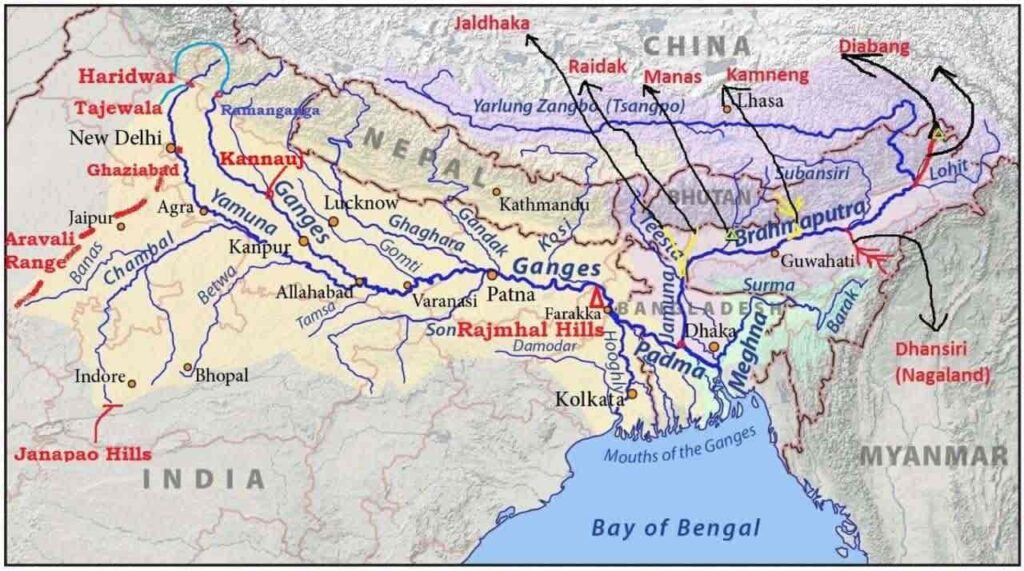
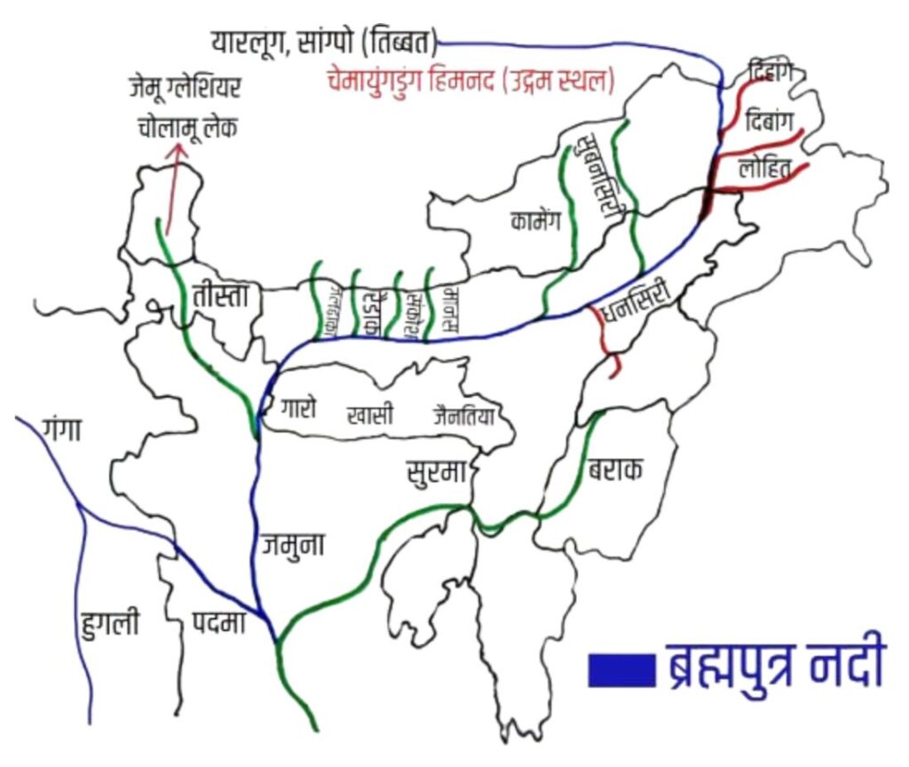
Brahmaputra River Drainage System
Brahmputra
- Length – 2900 km [916 km in India]
- Origin – Originates from Angsi Chemayungdung glacier of Kailash range near Mansarovar lake in Tibet and flows eastward as ‘Sangpo’ in Tibet.
- Total catchment (5.8 lakh km), In India (1.94 lakh km)
- Falls in – Bay of Bengal
- In Tibet, ‘Ragonsangpo‘ is the main river on its right bank.
- After this, cutting through the middle Himalayas near Namcha Barwa along the Syntaxial Bend, it turns southwards through Yangyap Pass (taking a U-turn – Dihang Gorge) and enters Arunachal Pradesh of India, where it is known as ‘Siang’ or ‘Dihang’ and after meeting the left bank of Dibang and Lohit rivers, it is known as ‘Brahmaputra’.
- Brahmaputra is known as Tsangpo in Tibet, Dihang in Arunachal Pradesh, Brahmaputra in Assam and Jamuna in Bangladesh. The people of Bodo tribe of Assam address the river as ‘Bhullam – Buthurbhi’.
- Many tributaries join the Assam valley bringing with them large amounts of water and sediment.
- The waterways are highly braided, leading to the formation of shallow areas – large river islands.
- Majuli river island in Assam, bounded by Lakhimpur district in the north and Jorhat district in the south.
- In Bangladesh
- Brahmaputra enters Bangladesh near Dhubri. There the river flows as Jamuna.
- Tista river joins Jamuna from the right side.
- After Jamuna and Ganga [Bhagirathi] meet it is called Padma. After Surma (Barak) meets Padma it is called Meghna.
- Before meeting the Bay of Bengal, the world’s largest delta, the Sundarbans Delta, is formed due to extensive silt deposition.
- Navigable from the Bay of Bengal to Dibrugarh (1280 km) [‘National Waterway Number-2’ (from Sadiya to Dhubri) has been built on the Brahmaputra River itself.]
- Many tributaries join below Pasighat-
- Left Bank – Dibang, Budhi Dihang, Lohit, Dhansiri, Kopili, Kallang, Barak, Disang. Right Bank – Subansiri, Kameng, Manas, Bhareli, Amo, Sankosh, Teesta
Note –Lohit River is also called ‘Bloody River’.
Major tributaries –
- Subansiri, which originates in Tibet, is an antecedent river.
- Sankosh – Bhutan’s main river, joins the Brahmaputra below Dhubri.
- Rangit River – Rangit River originating from Sikkim has a large number of tributaries. The river is famous all over the world for water sport ‘rafting’. Its basin is also suitable for ‘camping’.
- Kaldan River – Drains the southern part of Manipur and discharges into the Bay of Bengal.
- Manipur River – Originates from the northern part of Manipur and flows southwards. Passing through Imphal, it drains the Loktak Lake and joins the Chidwin Valley which is a tributary of the Irrawaddy in Myanmar.
- Barak River – Barak and Tuivai River ➟ Tipaimukh Hydroelectric Project.
- Tributaries- Maku, Tarang, Tuivai, Jiri, Sonai, Rukni, Kathkhal, Dhaleswari, Langchini, Maduwa and Jatinga
- Origin- Mount Japov and Manipur Hills in Nagaland.
- In Manipur it flows southwards and takes a sharp turn (hairpin bend).
- Barak Basin is drained by Mawsynram and Cherrapunji and the bulk of the water is discharged into Barak.
- The river named Surma flows towards Bangladesh. Barak river meets Padma at Chandpur below Dhaka, after which Surma (Barak) and Padma are jointly called Meghna.
- Teesta-
- It is the westernmost right bank tributary of the Brahmaputra.
- Origin – Originating from Kanchenjunga, it is a rapid mountain stream in the Darjeeling Hills
- Falls in –in the Brahmaputra River in Bangladesh
- Tributaries – Rangpo, Rangit, Sevok
- On the bank lies the city of Jalpaiguri, which was completely damaged in the flood of 1968.
- At present, the Tista river joins the Brahmaputra river in Bangladesh. The river changed its course in the flash flood of 1787, before it merges with the Ganga.
Peninsular drainage system
- The peninsular drainage system is older than the Himalayan drainage system. This is evidenced by the mature stage of the rivers and the broad, shallow river valleys.
- The Western Ghats of peninsular India act as a major water divide between the rivers falling into the Arabian Sea and the Bay of Bengal.
- The characteristic of peninsular rivers is that they flow on a fixed path, do not form meanders and are not perennial, although Narmada and Tapi flowing in fault valleys are exceptions to this.
- The rivers of South India mainly form tree-shaped drainage systems and have attained their base level.
- Due to the general slope of the peninsular plateau being towards the east and south-east, most of the rivers of peninsular India fall into the Bay of Bengal after originating from the Western Ghats. These rivers form deltas.
- The Narmada and Tapti rivers of peninsular India are exceptions and do not fall into the Bay of Bengal but into the Arabian Sea, because both these rivers flow through fault valleys and form estuaries.
- The Chambal, Sindh, Betwa, Ken and Son rivers originating in the northern part of the peninsula are part of the Ganga river system.
Evolution of Peninsular Drainage System
Three major geologic events of ancient times have shaped the drainage system of present-day peninsular India:
- During the early Tertiary period, the western flank of the peninsula subsided or sank, bringing it below sea level. This disturbed the normally symmetrical pattern of the river on both sides of the original watershed.
- The uplift of the Himalayas caused the northern portion of the peninsula to subside and as a result rift basins were formed. The Narmada and Tapi flow in these rift basins.
- During this period, the peninsula tilted from the north-west direction to the south-east direction. As a result, the drainage became directed towards the Bay of Bengal.
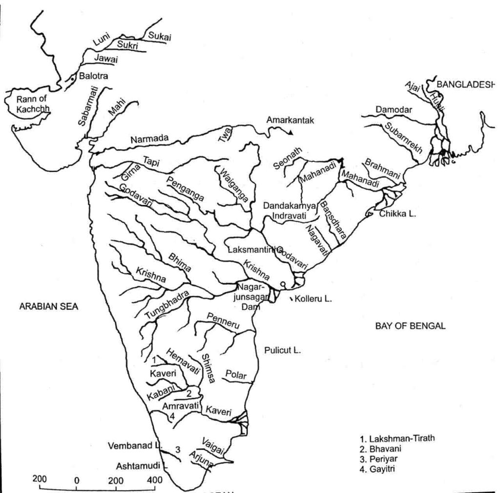
Major east-flowing rivers of peninsular India
Swarna rakha
- Origin – Chota Nagpur Plateau in the south-west of Ranchi.
- Falls in – Flowing in the eastern direction, it passes through Jamshedpur and meets the Bay of Bengal near Balasore.
- Drainage – Jharkhand ➟ West Bengal ➟ Odisha
- Tributaries – Kharkai, Raru and Kochi.
- Projects – Chandil Dam, Jamshedpur; Getal Sood Dam, Rukka Dam.
- Formation of Hundru Falls while falling from Ranchi plateau.
Vaitarni
- Origin – Keonjhar Hills, Odisha
- Falls in – Bay of Bengal.
- It is also called Ghamara River.
- Vaitrani and Brahmani together form a delta. Bhitarkanika mangroves in the delta region.
Brahmani River
- Origin – From the confluence of Koel + Shankh rivers at Rourkela. Drains the western part of Gadjat Hills.
- Falls in – North of Paradip in the Bay of Bengal, south of Bhitarkanika. Due to the presence of Vaitarni river in the north, a delta region was formed below Bhadrak.
- Drainage – Chhattisgarh ➟ Jharkhand ➟ Orissa. [Length – 420 km]
Vansh Dhara
- Origin – From the southern part of Odisha.
- This river falls into the Bay of Bengal.
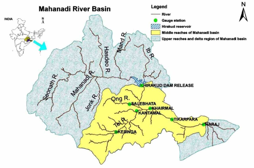
Mahanadi
- Drainage – Chhattisgarh ➟ Orissa [851 km length, catchment area approx. 1.42 lakh sq km]
- Origin – Sihawa Range (Chhattisgarh), Dandakaranya Plateau Raipur.
- Falls in – Forms delta in the Bay of Bengal.
- From its source the river flows towards north-east and after Sambalpur its flow becomes south and south-east.
- Tributaries-
- From left – Shivnath, Mand, Ib, Hasdeo
- From right – Jonk, Tel, Ong
- Navigation is also possible in its lower course.
- After the confluence of Shivnath and Sandur, the water jointly drains out towards the east through a gorge, where the water is blocked to form the Hirakund Dam [the dam has a 55 km long reservoir – Hirakund Reservoir].
- Cuttack is situated at the head of the Mahanadi delta.
- The river forms the plains of Chhattisgarh which is called the rice bowl of India.
- Major projects on Mahanadi River –
- Mahanadi Main Canal, Tandula Reservoir (Chhattisgarh), Hirakud Dam, Tikrapara Dam, Mahanadi Delta Project, Hasdeo Bango and Mahanadi Reservoir Project.
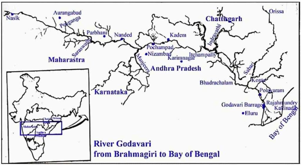
Godawari –
- Length – 1465 km. Catchment area – 3.13 lakh sq km
- Godavari is the largest peninsular river system. It is known as Dakshin Ganga, Budhi Ganga. Ganga of South India.
- Origin – Trayambakeshwar, Western Ghats [Nashik Maharashtra]
- Falls in – In the Bay of Bengal.
- Drainage state – Maharashtra ➟ Bastar, Chhattisgarh, ➟ Telangana.
- After Rajahmundry, this river divides into many streams and forms a large symmetrical delta. A major feature of the Godavari delta is the mangroves connected to many old canals and lagoons [Anoop]. [Lobate type of delta]
- At Davalverm, this river divides into two branches – Gautami and Vasishta
- Polavaram Dam [Andhra Pradesh]
- Tributaries –
- Tributaries on the left side – Purna, Pranhita, Penganga, Wardha, Venganga and Indravati, Sabari [Tributary – Sileru, Machkund] Bali Mela Project is situated on the Sileru River in Orissa. Duduma Falls is situated in the border area of Orissa and Andhra Pradesh.
- Chitrakote Falls is situated on the Indravati River
- Right side tributaries- Pravara, Manjara River [Nizam Sagar Dam – Telangana formed], Mula, Peddavagu, Maner.
- Tributaries on the left side – Purna, Pranhita, Penganga, Wardha, Venganga and Indravati, Sabari [Tributary – Sileru, Machkund] Bali Mela Project is situated on the Sileru River in Orissa. Duduma Falls is situated in the border area of Orissa and Andhra Pradesh.
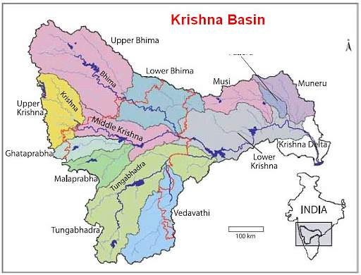
Krishna
- Length – 1401 km
- Origin – Western Ghats near Mahabaleshwar, Maharashtra
- Drainage – Maharashtra ➟ Karnataka ➟ Telangana ➟ Andhra Pradesh.
- Dams- Almatti Dam – Karnataka, Shivaji Sagar Dam – Maharashtra, Tugbhadra Dam – Karnataka and Nagarjuna Sagar – Telangana [on Tamil Nadu – Andhra Pradesh border] on Koyna River.
- Tributaries-
- Tributaries on the left side – Bhima, Musi.
- Tributaries on the right side – Koyna, Ghatprabha, Malaprabha and Tungabhadra. Longest river.
- Along the Musi River – Hyderabad, Nizam Sagar Lake.
- Forms a bird’s paw shaped delta.
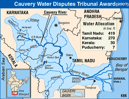
Kaveri
- Length – Approx 800 km.
- Origin – Brahmagiri Hills of Western Ghats, Karnataka.
- Falls in – Forms Quadrant delta a few km above Tiruchirappalli (Tamil Nadu).
- Drainage Area – Karnataka ➟ Kerala ➟ Tamil Nadu.
- Tributaries –
- Left side tributaries – Hemavathi, Shimsha, Arkavathi, Harangi.
- Right side tributaries – Lakshmana Tirtham, Kubbani, Bhavani, Amaravati [heavy industrialization in the basin ➟ high water pollution], Suvarnavathi, Noyel.
- Divided into two streams thrice.
- Formation of islands between the two streams – Srirangapatna (Karnataka) Shivasamudram (Karnataka), Srirangadeep (Tamil Nadu).
- Waterfalls
- Shivasamudram (Karnataka), Hogenakkal (Tamil Nadu),
- Dam
- Mettur Dam (Tamil Nadu) – formation of Stanley Reservoir.
- Krishnaraja Sagar (Karnataka) 20 km upstream from Mysore.
- It receives rainfall from Southwest Monsoon and Northeast Monsoon, hence it is perennial.
- Divides into two streams east of Tiruchirappalli – Coleroon, Cauvery
- Karaikal district of Puducherry – in Cauvery delta. [Famous for rice cultivation]
Pennar/peneru/pinakini
- Origin – Nandidurga Hill, Karnataka.
- 597 km long.
- Falls in – Bay of Bengal near Nellore
- Flows through Rayalaseema region of Andhra Pradesh in Chittoor and Nellore districts.
- Separates Palakonda from Nallamala and passes through Vellikonda range.
- Tributaries – Papagani, Chitravathi.
Palar River
- Origin – From Nandidurga hill,Karnataka
- Forms Bethamangala Tank, which is the main source of water supply to Kolar Gold Fields and Bharat Earth Movers Ltd.
- Falls in – Into Bay of Bengal near Kuvattur, Tamil Nadu
- River polluted by leather factories
Ponnaiyar River/Then Pennai River/South Pinakini River
- Origin – Nandidurga Hills of Karnataka
- Ends – In Bay of Bengal near Cuddalore in Tamil Nadu
- Krishnagiri Dam
Ponnaiyar River water dispute –
|
Vaigai
- Origin- Vashshanand Hills Tamilnadu.
- Falls in – Palk Bay, Tamilnadu.
- Madurai City, Ramanathapuram on the bank.
- Vaigai Dam [Tamilnadu]
Tamraparni/Porunai
- Origin – Eastern slope of Western Ghats, Agastya Malai hill
- Falls in – Gulf of Mannar.
- Tirunelveli town
- Perennial river
Major west-flowing rivers of peninsular India
Luni River
- Luni is the largest river system of Rajasthan to the west of Aravali. It originates near Pushkar in the form of two streams (Saraswati and Sagarmati) which join each other near Gobindgarh.
- Many tributaries like Bandi, Sukri and Jawai join its left bank
- The Luni river becomes salty below Balotra and ends in the marshy land of Kutch (‘Run of Kutch’) towards the south.
Mahi River
- Origin- Mehad Lake in Vidyanchal Hills near Sardarpura in Dhar district of Madhya Pradesh.
- Falls in- It passes through Panchmahal district of Gujarat and falls into the Gulf of Khambhat.
- Tributaries- Som, Jakham, Chap, Anas, Moren, Haran, Bhadra, Iru.
- The only river of India which crosses the Tropic of Cancer twice.
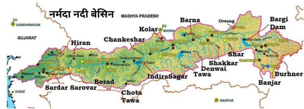
Narmada
- Length- 1312 km.
- Origin- From the western side of Amarkantak plateau, Madhya Pradesh.
- Falls in- Meets Gulf of Khambhat [Arabian Sea] south of Bharuch and forms a 27 km long estuary.
- Drainage area- Madhya Pradesh ➟ Maharashtra ➟ Gujarat.
- Flows through the fault valley between Vindhya mountains in the north and Satpura mountains in the south.
- Passes through a complex route near Jabalpur. Cuts through the marble rocks of Bhedaghat near Jabalpur and forms Dhuandhar waterfall. Other waterfalls- Dudhdhara, Kapildhara, Sahasradhara.
- Tributaries-
- From the right – hiran , Barna/Barna, Orsang
- From the left – Dudhi, Tawa, Sher, Kundi, Banjar.
- Projects
- Indira Sagar Project, (Indira Sagar Reservoir), Madhya Pradesh.
- Omkareshwar, Bargi and Maheshwar Project, Madhya Pradesh.
- Sardar Sarovar Project [Joint Project of Gujarat, Madhya Pradesh, Maharashtra, Rajasthan].
- Bharuch is on the banks of this river.
- There are many islands at the mouth of Narmada of which Aliabet is the largest. The Statue of Unity is located on Sadhubet Island.
Tapti
- Length – 724 km.
- Origin – From the Satpura Hills (place called Multai) in Betul district of Madhya Pradesh. Flows westward parallel to the Satpura.
- Estuary – Flows through the Surat plains and forms an estuary in the Gulf of Khambhat (an inlet of the Arabian Sea).
- Drainage area – Madhya Pradesh ➟ Maharashtra ➟ Gujarat.
- Surat city is situated on the banks of the river.
- Narmada and Tapi come close to each other near the Khandwa-Burhanpur pass.
- Flows through the rift valley between the Satpura and Ajanta ranges.
- Tributary rivers-
- Girna on the left bank and Arunavati river on the right bank.
- Other rivers – Aner, Bori, Purna, Betul, Guli, Dhatranj, Kshipra, Mon, Patki.
- projects
- Hathnoor Dam of Upper Tapi Project (Maharashtra)
- Kakrapar Dam and Ukai Dam of Ukai Project (Gujarat)
- Girna Dam and Dahigam Dam of Girna Project (Maharashtra)
- The Tapti basin has two physical regions, viz. hilly areas and plains; the hilly regions comprising the Satpura, Satmala, Mahadev, Ajanta and Gawilgadh hills are well forested.
- The plains cover the Khandesh areas (northwestern part of Maharashtra state), which are vast, fertile and mainly suitable for cultivation.
Mandvi
- Origin – Western Ghats Karnataka Belgaum District Jaboti Ghat
- river mouth – Goa Nandmukh Arabian Sea.
- Lifeline of Goa.
- Passes through Bhimgad Wildlife Sanctuary.
- Dudhsagar Falls and Vajra Poha Falls are also there in Goa.
- Capital of Goa Panaji is on the banks of the river.
- Chiarao Deep Salim Ali Bird Sanctuary.
- Tributaries – Mandovi, Khandepar.
Juari
- Origin – Hemad-Barsham in the Western Ghats.
- Falls in – Arabian Sea (Goa) .
- It is a tidal river.
- The longest river flowing in Goa.
- The Kambarjum Canal connects Mandovi and Zuari.
- The Mormugao port is at the confluence of the river.
Sharavati River
- Origin- Shimoga (Karnataka).
- Falls in- Arabian Sea.
- Garsopa Falls/Jog Falls – 271 m, Karnataka.
Other rivers draining the western slopes of the Western Ghats are Ulhas, Savitri, Vasishta, Netravati, Periyar and Pambiar
Bharathapuzha / Ponnani River
- Origin – Anamalai Hills of Western Ghats, Tamil Nadu
- Falls in – Arabian Sea near Ponnani town
- The only breach in the unbroken watershed of Western Ghats is the 13 km wide Palakkad Pass, also called Palghat. Ponnani River flows westwards through this pass.
- It is the second longest river in Kerala, after Periyar River. [250 km, Kerala – 209 km]
- Three important structures – Aliyar Reservoir, Thirumoorthy Reservoir and Malampuzha Reservoir.
Periyar
- Origin – Sivagiri Peak, Kerala.
- Falls in – Arabian Sea, north of Vembanad Lake.
- Longest and largest river of Kerala state. [244 km]
- Projects – Idukki Project [Water supply for irrigation and domestic use, hydroelectric power], Mullaperiyar Dam.
Pamba River
- Origin – Pulachimalai Hills, Kerala
- Falls in – Vembanad Lake
- The third longest river in Kerala, South Bhagirathi, after Periyar and Bharathapuzha River
- Religious significance – Sabarimala temple dedicated to Lord Ayyappa is situated on the banks of the Pamba River.
- Hydroelectric project – Sabarigiri Hydroelectric project.
Difference between Himalayan and Peninsular rivers
Rivers of the Himalaya Mountains | Rivers of Peninsular Plateau |
Himalayan rivers are long and have wide catchment areas | The rivers of the peninsular plateau are relatively short in length and have relatively small catchment areas. |
Rivers get water from rain as well as snow, hence these are perennial rivers. | Rivers are mostly seasonal. Their source is rain, so they dry up in the summer season. |
Rivers create deep valleys and gorges. | The valleys of peninsular rivers are less deep and shallow. |
Himalayan rivers form meanders and also keep changing their course. | Follow a relatively straight path and do not change course. |
The Himalayan rivers are still in their youthful stage of development. | The peninsular rivers have reached maturity. |
Himalayan rivers generally precede and follow | Peninsular rivers generally follow, superimpose and rejuvenate. |
The rivers of the Himalayas form large deltas. The Ganga-Brahmaputra is the largest delta in the world. | Peninsular rivers form estuaries or small deltas relatively close to their mouths. For example, Narmada and Tapti estuaries. |
These rivers are favourable for navigation and irrigation. | These rivers are not suitable for navigation and irrigation. |
Following are some of the important waterfalls in India
Gersoppa or Jog Falls(Mahatma Gandhi Falls) | Sharavati River (Karnataka) |
Shivasamudram Falls | Cauvery River (Karnataka) |
Dhuandhar Falls (Marble Falls) | Narmada River (Madhya Pradesh) |
Chulia Falls | Chambal River (Rajasthan) |
Gokak Falls | Gokak River (Karnataka) |
Punasa Falls | Chambal River |
Maghar Falls | Chambal River |
Hundru Falls | Swarnarekha River (Jharkhand) |
Chachai Falls | Bihar River (Madhya Pradesh) |
Dudhsagar Falls | Mandovi River (Goa-Karnataka border) |
Kiliyur Falls | Kiliyur River (Tamil Nadu) |
Silver Falls | Pachmarhi (M.P.) |
Yamuna Falls | Pachmarhi (Madhya Pradesh) |
Vasudhara Falls | Alaknanda River (Uttarakhand) |
Dussam Falls | Kanchi River (Jharkhand) |
Yanna Falls | Yanna Valley (Maharashtra) |
Chitrakoot Falls | Indravati River (Chhattisgarh) |
Aathirapalli Falls | Chalakudy River (Kerala) |
Kempty Falls | Mussoorie (Dehradun) Uttarakhand |
Kakolat | Nawada (Bihar) |
Pykara Falls | Pykara River (Tamil Nadu) |
Papanasam Falls | Tamraparni River (Tamil Nadu) |
Problems of river water use
- Lack of availability of sufficient water
- River water pollution
- Silt in river water
- Uneven flow of seasonal water
- River water disputes between states
- Shrinking of river channels due to expansion of settlements
Major river water disputes of India
River water dispute | Related States |
Godavari River Water Dispute | Andhra Pradesh, Karnataka, then Madhya Pradesh, Odisha and Maharashtra |
Krishna river water dispute | Andhra Pradesh, Karnataka and Maharashtra |
Narmada River Water Dispute | Madhya Pradesh, Gujarat and Maharashtra, Rajasthan |
Ravi-Beas river water dispute | Punjab, Haryana and Rajasthan |
Cauvery water dispute | Kerala, Karnataka, Tamil Nadu and Puducherry |
Krishna River Water Dispute- II | Karnataka, Telangana, Andhra Pradesh and Maharashtra |
Vansadhara River Water Dispute | Andhra Pradesh and Odisha |
Mahanadi Water Disputes Tribunal | Odisha and Chhattisgarh |
Mahadai River Water Dispute | Goa, Karnataka and Maharashtra |
