
In World Geography, volcanoes are dynamic geological structures that erupt molten rock, ash, and gases, shaping Earth’s surface. Their diverse types, distribution along tectonic plate boundaries, and their effects on ecosystems and human societies make them a vital subject of study.
Previous Year Question
| Year | Question | Marks |
| 2016 | What is a ‘cinder cone’ volcano? | 2 M |
| 2018 | What is fissure volcanic eruption? Tell us about the areas of their presence in the world. | 5 M |
| 2021 | Describe the Circum-Pacific Belt of volcanoes. | 5 M |
| 2023 | M |
Volcanoes: Types, distribution and their effects
- A volcano is usually a round shaped vent or opening in which liquid lava, water, gas and pieces of rocks come out from the core of the earth to the surface of the earth.
- According to S.W. Wooldridge and R.S. Morgan, “Volcanism includes all those processes in which molten rock material or magma appears within or above the earth’s surface and solidifies in the form of crystalline or semicrystalline rock.
There are two forms of volcanic activity:
- In internal action, magma freezes and solidifies in the inner part below the surface of the earth. This action creates some structures, among which batholith, phacolith, laccolith, sill, dyke are the main ones.
- In external action, magma appears in various forms above the surface of the earth, the main ones being volcano, fissure flow, geyser, fumarole and hot spring.
This makes it clear that volcano is a form of volcanic activity.
Causes of Volcanic Eruption
Volcanoes erupt both internally and externally. Internal eruptions cannot be seen directly. Therefore, based on some facts of external eruptions, the following are the causes of volcanic eruptions –
- Excessive temperature in the Earth’s core – High temperatures in the Earth’s interior occur due to the decay of radioactive materials, chemical reactions, and the pressure exerted from above. This extreme heat causes deep-seated materials to melt. These molten materials escape through weak spots in the Earth’s crust, leading to volcanic eruptions.
- Tectonic activities – Volcanic eruptions occur due to the movement of plates. Volcanic activities occur at the convergent and divergent plate boundaries.
- Earthquake – In earthquake-prone areas, cracks often form, increasing the likelihood of volcanic eruptions from these fractures.
- Reduction in pressure – Due to the pressure of the upper layers, the rocks of the earth remain in solid state. Due to the reduction in pressure, the melting point decreases, due to which the rocks melt and magma is formed, which encourages volcanic activity.
- Isostasy adjustment – The earth maintains a balance in high and low areas, but whenever the load in the sea areas increases due to the debris deposited by erosion, this balance system gets disturbed temporarily. Due to geological imbalance, structural changes occur in geological areas, which leads to volcanic activity.
- Presence of weak terrain – The Andes mountain region, coastal areas of the Pacific Ocean and the Western Islands are the main examples of this.
- Origin of gases – Groundwater reaches the inner part of the earth through cracks and gets converted into vapor which acts as the propelling force in the eruption.
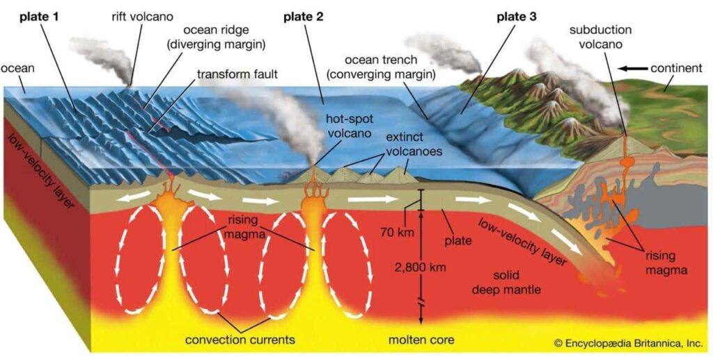
Volcanism and plate tectonics –
- Due to the disintegration of radioactive elements in the inner layers of the earth, convection currents are generated due to high temperature which are mainly responsible for the movement of plates.
- Due to the effect of convection currents, divergent, convergent and conservative plate movement takes place in the plates, but only divergent and convergent plate movement is related to volcanism.
- At divergent plate boundaries, plates move away from each other, causing faulting. Due to the reduction in pressure, fissure-type volcanic activity occurs.
- As a result, basaltic lava forms oceanic ridges (e.g., Mid-Atlantic Ridge) in ocean basins and basaltic plateaus (e.g., Deccan Plateau) in continental regions.
- At convergent plate boundaries, a denser plate subducts beneath a less dense plate into greater depths.
- Due to high temperature and pressure, magma is generated.
- When this magma breaks through the Earth’s interior layers and reaches the surface, it forms volcanic mountains (e.g., the Andes volcanic range) in continental regions and volcanic islands in oceanic regions.
Material ejected from a volcano
The materials released from volcanic eruptions are divided into three categories.
- Gases and Water Vapor: During volcanic eruptions, a large amount of gases is released, with 60-90% consisting of water vapor. Other gases include: Sulfur dioxide (SO₂), Nitrogen (N₂), Ammonium chloride (NH₄Cl) Carbon dioxide (CO₂), among others.
- Fragmented Materials: Along with gases, solid materials, fine dust particles, and ash, as well as large chunks of rock, are expelled during eruptions. These fragments vary in size, from a few inches to several feet in diameter.
- Types of Volcanic Fragments:
- Lapilli – Pebble or walnut-sized fragments.
- Volcanic Ash – Very fine particles of dust and ash.
- Volcanic Bombs – Large, solid rock fragments.
- Volcanic Breccia – When small, angular lava fragments stick together, forming solidified volcanic rock.
- Types of Volcanic Fragments:
- Lava material- When the material coming out of a volcano is in the form of liquid or fluid, it is called ‘lava’.
Based on the silica, lava is of two types –
- Acidic Lava (Felsic Lava)
- Highly viscous and thick.
- Yellow in color and lightweight.
- Melts at a high temperature.
- Contains a high amount of silica.
- Usually erupts explosively and forms tall, conical volcanoes.
- Example: Rhyolite
- Basic Lava (Mafic Lava)
- Thin and fluid in molten form.
- Dark-colored, black, and heavier.
- Melts at a lower temperature.
- Spreads quickly over the surface due to low viscosity.
- Contains less silica and solidifies rapidly.
- Erupts with less explosion, forming plateaus or plains.
- Example: Basalt
Note – Andesite Lava – Intermediate between acidic and basic lava, neither too acidic nor too alkaline.
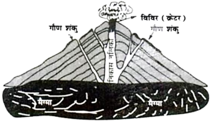
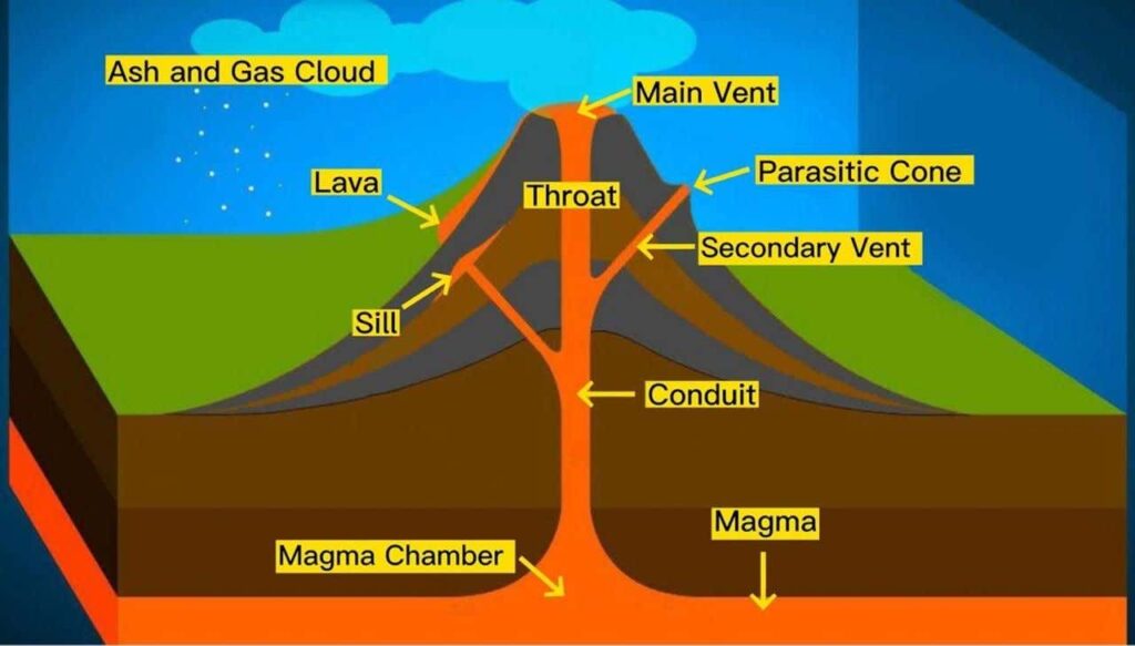
Structure of volcano
- The material ejected from a volcano comes out through a natural channel called a “Volcanic Pipe.”
- The opening through which lava emerges onto the surface is known as a “Volcanic Vent.”
- When this vent expands, it forms a “Volcanic Crater.”
- As the erupted material accumulates around the volcanic vent, it gradually builds a cone-shaped mountain, known as a “Volcanic Mountain.”
- When lava escapes from secondary vents on the sides of the main volcanic pipe, it forms small cone-like structures called “Secondary Cones.”
Classification of volcano
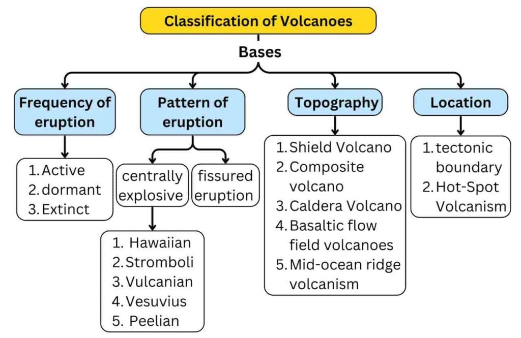
- Due to the difference in the time of volcanic eruption and its activity, volcanoes are classified into the following parts.
A. The classification on the basis of frequency of eruption –
Some volcanoes erupt very quickly and some volcanoes erupt for a long time. Based on the frequency of their eruption, they are classified into three categories-
- Active volcano –
- When lava, gas and fragmented material keep coming out continuously from a volcano, it is called an ‘active volcano’.
- Etna, Stromboli of Sicily Island [Italy], Barren Island [Andaman Nicobar], Erebus [Antarctic], Mauna Loa [Hawaiian Islands], Mayon [Philippines] are its major examples.
Note –
- The area around Stromboli volcano remains illuminated due to the continuous emission of gases. That is why it is called the ‘Lighthouse of the Mediterranean Sea’.
- Cotopaxi volcano is the world’s highest active volcano. (Height 5879 m.)
- Dormant Volcano –
- Volcanoes that have not erupted for a long time but still have the possibility of erupting are called dormant volcanoes.
- Vesuvius (Italy), Krakatoa (Indonesia), Fujiyama (Japan), Narcondam [Andaman Nicobar] are its major examples.
- Extinct volcano –
- Such volcanoes in which the eruption has completely stopped and there is no possibility of eruption in future are called dormant volcanoes.
- Due to water filling in the mouth of these volcanoes, a crater lake is formed.
- Koh Sultan and Demvand (Iran), Mount Popa (Myanmar), Kilimanjaro [Tanzania], Aconcagua [Argentina], Chimborazo [Ecuador] are examples.
B. Based on eruption–
Volcanic eruption occurs in two forms.
- When a lot of lava, gas and fragmented material comes out of the surface in the form of an explosion through holes and pipes.
- When the intensity of the gas decreases, liquids come out of the surface quietly through cracks.
On the basis of the above mentioned forms, volcanoes are classified into two parts
- Volcanoes with central eruptions
- Volcanoes with surface or fissure eruptions
1. Central eruption volcano
- Eruptions occur through a narrow volcanic pipe leading to an opening (vent).
- When lava contains a high amount of gas and there is a decrease in pressure from above, the gases and lava rapidly rise with great force.
- This intense pressure breaks through weak zones of the Earth’s crust, releasing lava onto the surface with a loud explosion.
- Due to the high intensity of gases, volcanic material is ejected high into the sky, forming thick, dark clouds of vapor, gas, and smoke.
- After some time, fragmented material and lava fall back to the ground like rain.
- The liquid lava accumulates around the vent, forming a volcanic cone or dome.
- Due to violent explosions, these volcanoes are highly destructive.
- Hawaiian type of volcanic eruption–
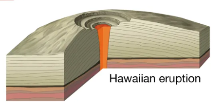
- Hawaiian-Type Volcanoes
- The lava of these volcanoes is thin and contains low gas pressure.
- As a result, eruptions are less explosive and occur in a calm manner.
- During the eruption, small red lava blobs rise along with gases.
- The wind carries these blobs, making them appear like floating strands of hair.
- Hawaiian natives consider these strands as the “hair of the fire goddess Pele.”
- Characteristics: These eruptions create low-elevation landforms with gentle slopes, resembling Shield Volcanoes.
- Such volcanic eruptions commonly occur on the Hawaiian Islands, hence called “Hawaiian-type volcanoes.”
- Example: Kilauea Volcano.
- Strombolian-Type Volcanoes

- These eruptions are more intense compared to Hawaiian-type volcanoes.
- Lava is less fluid and more viscous.
- Due to obstructions in the gas pathways, explosive eruptions occur.
- Gases escape continuously or intermittently.
- Along with liquid lava, fragmented materials such as pumice, scoria, volcanic ash, and volcanic bombs are also ejected.
- The Stromboli Volcano on the Lipari Islands is known as the “Lighthouse of the Mediterranean Sea.”
- Due to this characteristic, such volcanoes are called “Strombolian-Type Volcanoes.”
- Vulcanian type of volcanic eruption–
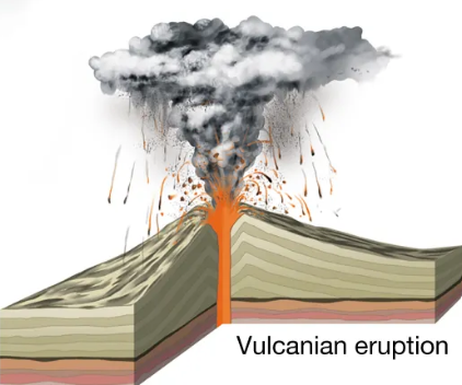
- The lava of these volcanoes is highly viscous and sticky (pasty).
- It solidifies at the volcanic vent, blocking it.
- When gases accumulate in large amounts, they erupt violently, leading to an explosive eruption.
- After the explosion, dense clouds of ash and dust rise, often resembling a cauliflower shape.
- These volcanoes are named after the Volcano located in the Lipari Islands.
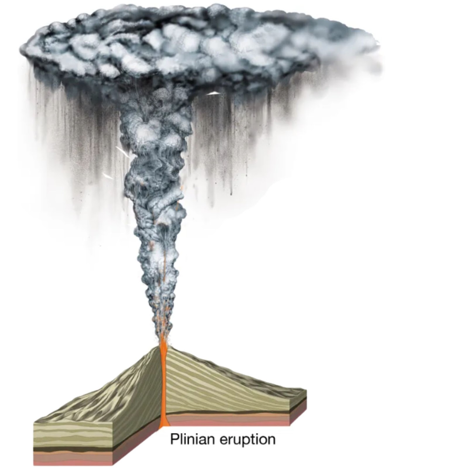
- Vesuvius-Type Volcanic Eruption (Plinian Eruption)
- These volcanoes are similar to the Vulcanian type.
- Lava is highly gas-rich, and the intense gas pressure causes volcanic material to be ejected to great heights.
- The volcanic cloud forms a cauliflower- shaped structure.
- Gases can rise beyond the troposphere and reach the stratosphere.
- The clouds are so dense that they completely obscure visibility.
- Named after the Vesuvius Volcano in Italy. Roman historian Pliny observed this type of eruption during the AD 79 eruption of Mount Vesuvius, hence it is also called a “Plinian-Type Volcanic Eruption.”
- Pelean-Type Volcanic Eruption
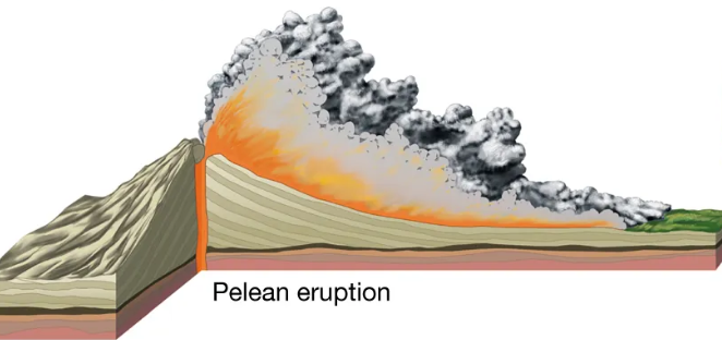
- These are the most destructive and violent types of volcanic eruptions.
- The lava is extremely viscous and pasty.
- Lava accumulates at the volcanic vent, hardens, and forms a solid cap.
- During the next eruption, intense gas pressure breaks through this solid layer, ejecting lava and other materials with a loud explosion.
- Due to the ignition of gases, volcanic clouds appear to glow.
- Formation of “Nuee Ardentes” or “Glowing Cloud” is a characteristic feature of these eruptions.
- Named after the deadly eruption of Mount Pelée on the island of Martinique in 1902.
- Notable Examples: 1883 – Krakatoa, Indonesia,1911 – Mount Taal, Philippines.
2. Fissure eruption volcano–
- Volcanoes with such eruptions are rarely found on Earth.
- Eruptions occur through long cracks (fissures) rather than a central vent.
- Lava is alkaline and flows out slowly and calmly with minimal explosion.
- Due to its fluid nature, lava spreads over vast areas instead of forming a volcanic cone or mountain.
- Instead of mountains, these eruptions create lava plains and lava plateaus.
- Columbia Plateau of USA, Parana Plateau of Brazil and Deccan Trap of India, Drakensberg Plateau of South Africa are its main examples.
Icelandic-Type Volcanic Eruptions

- These volcanoes erupt through fissures, releasing lava gently and continuously.
- The lava is alkaline and spreads over a vast area, forming volcanic plateaus.
- Columbia Plateau (USA) and Deccan Plateau (India) are examples of lava plateaus formed by fissure eruptions.
- Basalt flow regions belong to this type.
- Example: Volcanoes in Iceland (Europe).
Note-
- In 1783, a 27 km long fissure eruption in Iceland released lava, covering about 348 km in length. This eruption caused the destruction of one-fifth of Iceland’s population.
- Fissure eruptions occurred on a large scale during the Cretaceous period, and their traces can still be found in many regions.
- During Earth’s early cooling phase, the crust was thinner, making it more prone to fissures.
- As a result, fissure eruptions were more frequent in Earth’s early history but have become rare today.
- Mud Volcanoes – These are found in natural gas and petroleum-producing regions.
- The sand and clay mixed with water create mud, which solidifies into various formations.
- Example: Bog-Boga Mud Volcano near the Baku oil fields, close to the Caspian Sea.
C. Types of volcanoes based on topography
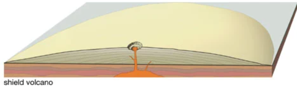
- Shield volcano –
- These volcanoes are less explosive and erupt alkaline lava.
- If water enters the volcanic conduit, the eruption becomes more explosive.
- Such eruptions create low-elevation landforms with gentle slopes.
- Shield volcanoes are commonly found in the Hawaiian Islands.
- Composite Volcano / Strato Volcano
- These volcanoes are highly explosive.
- During this type of eruption, gases, ash, volcanic material etc. also come out along with the lava.
- These volcanoes form layered, high-elevation landforms.
- Example – Hood, Rainier.
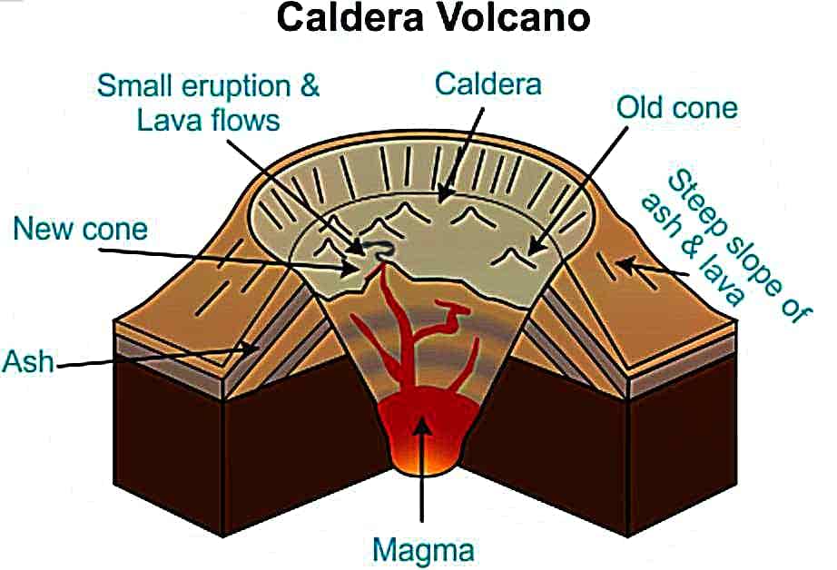
- Caldera-Type Volcanoes

- These volcanoes are the most explosive.
- Their explosiveness indicates that the magma chamber is large and located close to the surface.
- Instead of forming high landforms, the surface collapses during an eruption, creating a vast depression called a “caldera.”
- Example: Aso Volcano (Japan).
- Basaltic flow field volcanoes
- These volcanoes are not explosive.
- During eruptions, alkaline lava flows through fissures.
- Due to its fluid nature, the lava spreads over vast areas, forming basalt flow regions.
- Examples: Deccan Traps (India) , Siberian Basalt Flow Region
- Mid-Ocean Ridge Volcanoes
- These volcanoes are less explosive.
- They are found at divergent plate boundaries in the oceans.
- Their eruptions contribute to the formation of mid-ocean ridges.
- Example: Mid-Atlantic Ridge.
D. Based on geographical location
1. Plate margin volcanism
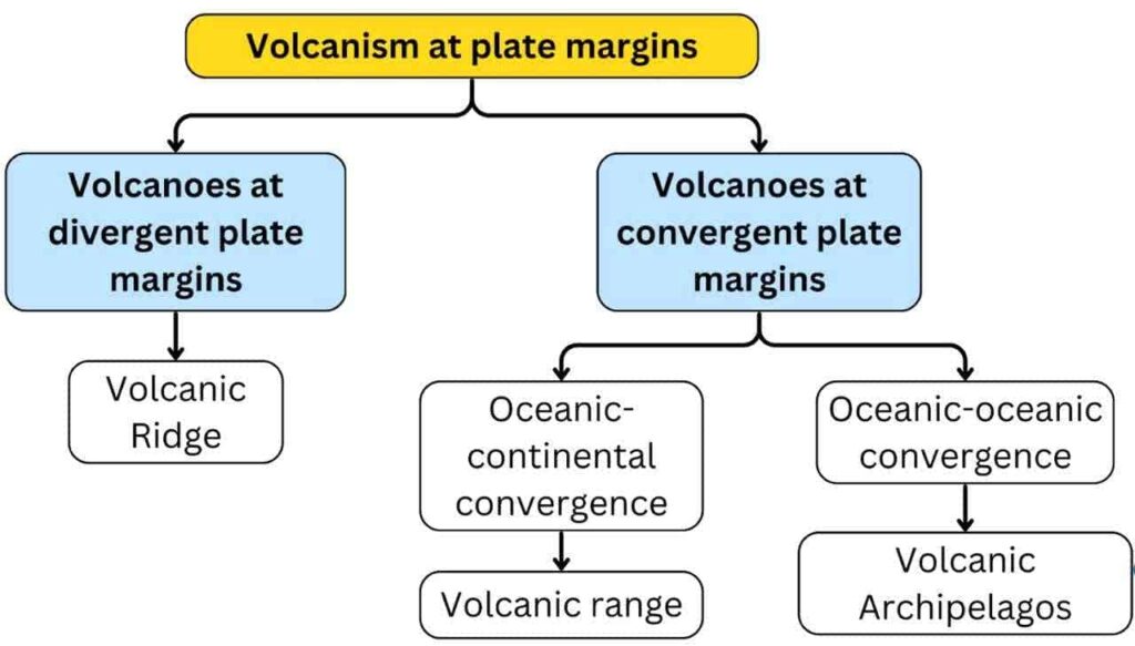
- Divergent plate margin volcanoes –
- As the width of fault valleys increases due to divergent plate motion, pressure decreases.
- This leads to the melting of peridotite, generating alkaline magma. When this magma reaches the surface, it forms mid-ocean ridges through a calm fissure-type volcanic process.
- Such as – Mid-Atlantic Ridge (Dolphin and Challenger Ridge), Indian Ocean Ridge (Socotra and Chagos Ridge), Pacific Ocean Ridge (Hawaiian and South Honshu Ridge)
- Convergent plate boundary volcanoes –
- At convergent plate boundaries, where oceanic plates collide, the denser oceanic plate subducts into the mantle.
- As the subducted plate sinks deeper, the increase in temperature causes partial melting of the crust, generating magma.
- When this magma breaks through the Earth’s interior layers and reaches the surface, it results in explosive central vent volcanic activity.
- In the eastern Pacific Ocean, subduction has led to the formation of a “Volcanic Mountain Chain” along the fold mountain regions.
- In the western Pacific Ocean, subduction has resulted in the formation of “Volcanic Island Chains.”
Note- The part of the oceanic plates where earthquakes originate after subduction is called the ‘Benioff Zone’.
2. Hot-Spot Volcanism
- Hot-spot volcanism occurs away from plate boundaries, where a fixed “hot spot” deep inside the Earth’s mantle generates magma due to higher temperatures.
- Oceanic plates are thinner compared to continental plates, making it more likely for magma from a hot spot to reach the ocean floor.
- A single hot spot can form a “Volcanic Chain” as the moving plate carries older volcanoes away from the active hot spot.
- By analyzing the alignment of volcanic chains, scientists determine the movement direction of tectonic plates, as hot spots remain fixed while plates move.
- Multiple hot spots can create a “Volcanic Cluster.”
- A classic example of hot-spot volcanism is observed near the Hawaiian Islands in the Pacific Ocean.
Topography created by volcanic action
- The landforms created by volcanic activity depend upon the proportions and properties of fragmented material and lava.
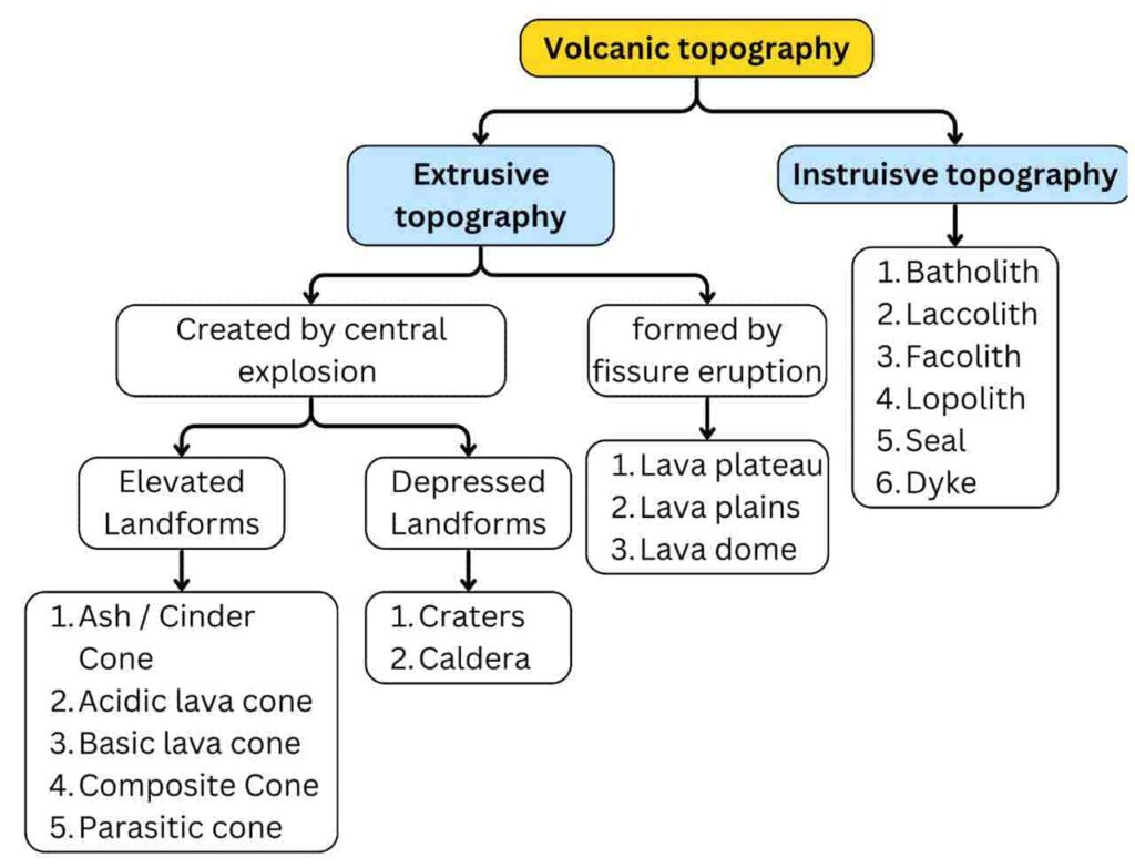
- The eruption of a volcano occurs both below and above the Earth’s surface. Based on this, volcanic landforms are classified into the following types:
A. Extrusive Topography
- External topography is created by volcanic eruptions outside the Earth’s surface.
1. Created by central eruption–
The topographies formed by volcanic central eruption can be classified into two parts–
- Elevated Landforms
- Depressed Landforms
i. Elevated Landforms
- Intense gases, lava and fragmented material escape from the central eruption and get deposited near the volcanic vent, which leads to the formation of many types of cones, the main landforms of which are as follows:
- Cinder or ash cone–
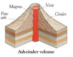
- The lava ejected from a volcanic eruption quickly cools and solidifies into fragments known as cinders.
- These resemble ash in appearance. The conical shape formed by volcanic dust, ash, and fragmented materials is called a cinder cone. There is no contribution of liquid material in its formation.
- Its height is generally low, and the slope is concave.
- Mount Izalco of San Salvador, Camiguin volcano of Philippines, Jorello of Mexico are its main examples.
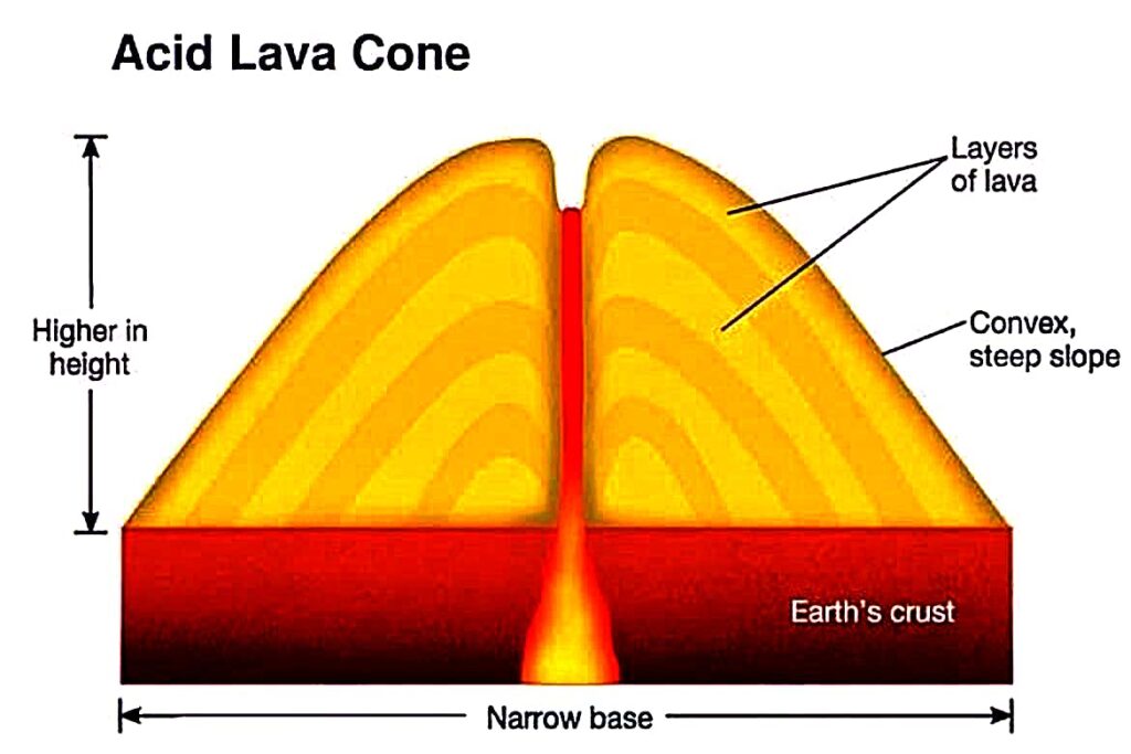
- Acid lava cone–
- Such cone-shaped formations are created by acidic lava.
- Due to the high silica content in the lava, it becomes very viscous and thick.
- As a result, when the lava reaches the surface, it cools and solidifies quickly, forming steep-sloped cones.
- Example – Pie de Dome in France and Stromboli in Italy.
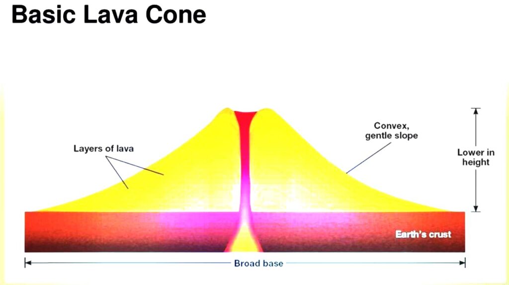
- Basic lava cone–
- The amount of silica in lava is less and due to lava being light and thin, it spreads far and wide.
- This leads to the formation of cones of low height. Due to their shield-like shape, they are also called shield cones.
- These cones are formed from basaltic lava, which is why they are called “Basic or Pahoehoe Lava Cones.”
- For example – Maunaloa cone of Hawaii island.
- Composite cone –
- These types of cones are formed by the accumulation of various volcanic materials, such as lava, ash, and fragmented debris, layer by layer. Hence, they are also called Strato Cones (Composite Volcanoes).
- Among all types of volcanic cones, these are tall and large.
- When the upper part of these cones is covered with lava, erosion is minimal.
- However, when they are covered with unconsolidated fragmented materials, erosion occurs rapidly. Due to this, they are also called Mixed Cones.
- Mayan of the Philippines, Fujiyama of Japan, Shasta, Rainier and Hood of the United States of America etc. are notable examples.

- Parasitic cone-
- When a volcano expands significantly, it begins to fracture, leading to the formation of small branches from the main conduit.
- Due to the deposition of lava and other volcanic materials from these secondary branches, smaller cones start forming on the main volcanic cone.
- Sometimes, these secondary cones can grow almost as large as the main cone.
- Since these cones receive magma supply from the main volcanic conduit, they are called Parasitic Cones.
- Shastina Cone is an example of a parasitic cone of Mount Shasta.
ii. Depressed Landforms
- When a part of the volcano is removed or collapses downward during an eruption, it forms what is known as a “Depressed Area” or “Subsided Region.”
- Caldera cones and craters are the main landforms.
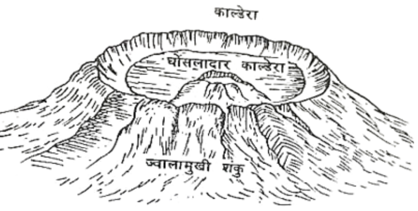
- Crater-
- The part located above the volcanic vent is called the “Crater” or the “Mouth of the Volcano.” Shape: Bowl-like.
- The size of the crater depends on the cone in which it is formed.
- When rainwater fills the crater, a crater lake is formed.
- Examples: Oskjuvatn Crater Lake in Iceland, Crater Lake in Oregon, USA , Lonar Lake in Maharashtra, India
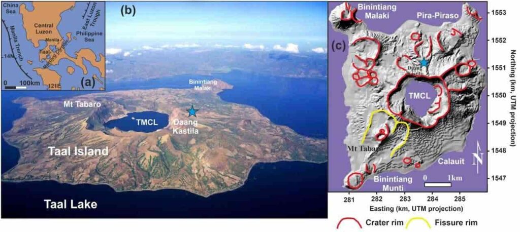
- When multiple small craters are found inside a large crater due to repeated volcanic eruptions, it is called a Nested Crater.
- Example: Mount Taal in the Philippines, where the main crater contains three craters.
- Caldera cones –
- The formation of a caldera occurs due to the collapse of a crater. A large crater-like structure is called a caldera.
- According to Daly, a caldera is formed due to an explosive volcanic eruption.
- A major example is the Aso Caldera in Japan.
- A very large caldera is called a Super Caldera.
- A notable example of a super caldera is Lake Toba, located at the summit of the Barisan Highlands in Sumatra.
- When a new volcanic cone forms inside a caldera due to subsequent eruptions, and further explosive activity leads to the formation of another caldera, such a structure is called a Nested Caldera.
2. Created by fissure eruption– Volcanic lava reaches the Earth’s surface through fissures. Due to its fluid state, it spreads rapidly over the surface. As a result, a thin or thick layer of lava gets deposited on the ground.
With the successive accumulation of these layers, lava plateaus and lava plains are formed.
- Lava plateaus– Volcanic erupted materials accumulate in highland regions, leading to the formation of lava plateaus. Deccan Plateau of India, Columbia Plateau of USA are examples of lava plateau.
- Lava plains– Lava, fragments, and ash from volcanic eruptions fill uneven and rugged terrains, resulting in the formation of lava plains. The fertile plains near the Naples plateau in Italy are made up of the material ejected by the Vesuvius volcano.
- Lava dome– Unlike composite and shield volcanoes, lava domes are relatively small in size.
- They form when the lava is highly viscous, preventing it from flowing over long distances.
- As the lava dome gradually grows, its outer surface cools and hardens, while molten lava continues to accumulate inside.
- Eventually, internal pressure can fracture the hardened surface, causing loose fragments to collapse around its edges.
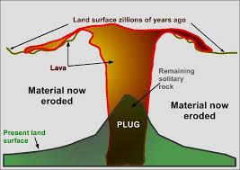
Note – Lava plug
- When a volcano becomes inactive, its vent and conduit get filled with solidified lava.
- After the erosion of the volcanic cone, the hardened lava in the conduit appears as a wall-like structure, known as a Volcanic Neck.
- Examples: Black Hills, Devil’s Tower
- When the volcanic vent gets filled with lava, it forms a cap-like structure, called a Volcanic Plug or Cap.
- If the volcanic vent and conduit get filled with breccia (fragmented rocks), the structure is called a Diatreme.
- Example: Shiprock in New Mexico, USA.
B. Instruisve Topography
- When lava from a volcanic eruption does not reach the Earth’s surface but solidifies beneath the surface, the resulting landforms are called Intrusive or Plutonic Landforms.
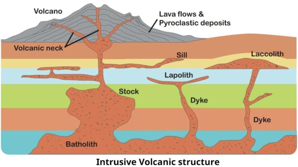
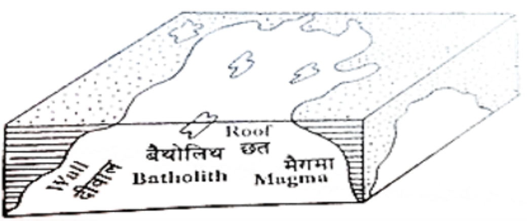
- Batholith –
- Large dome-shaped intrusive landforms formed by the solidification of magma above a magma chamber.
- When a large mass of magma cools deep within the Earth’s crust, it develops into a dome-like structure. These structures have a deep-seated base and steep edges.
- The upper surface of a batholith is often rough and uneven.
- Batholiths are large dome-shaped formations primarily composed of granite.
- Smaller batholiths are called Stocks. They have a rounded upper surface and share similar characteristics with batholiths.
- Example – Idaho Batholith of USA, Coast Range Batholith of Western Canada, Ranchi Batholith of India.
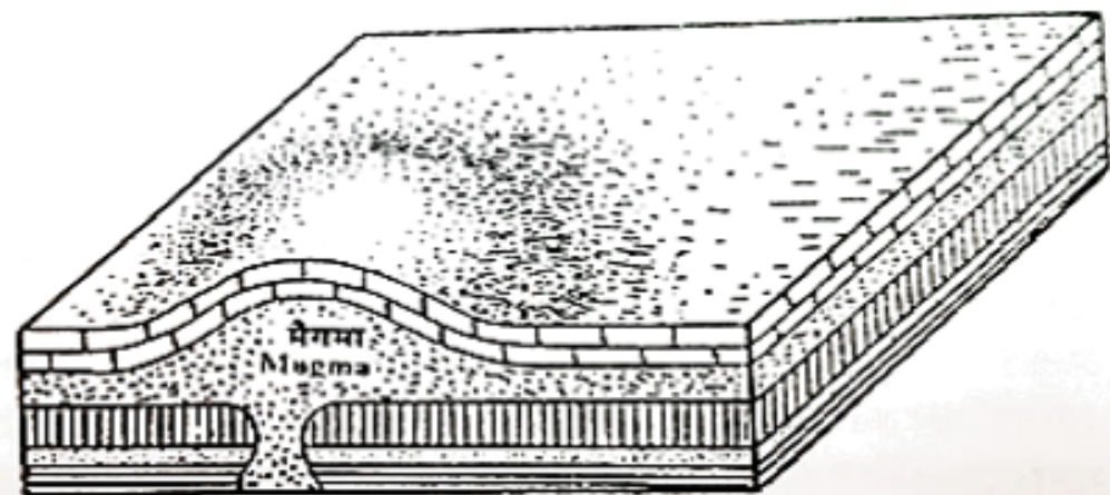
- Laccolith –
- These are large, dome-shaped intrusive igneous formations with a flat base, connected to a pipe-like conduit from below.
- During volcanic eruptions, the pressure of escaping gases causes the upper layers of sedimentary rock to bulge into a dome shape, forming a laccolith.
- Laccoliths are mainly found between sedimentary rock layers.
- Note: Batholiths can form in any type of rock.
- Laccoliths are only formed within layered sedimentary rocks.
- Such structures are found in the western part of North America and the Chhota Nagpur plateau region of India.
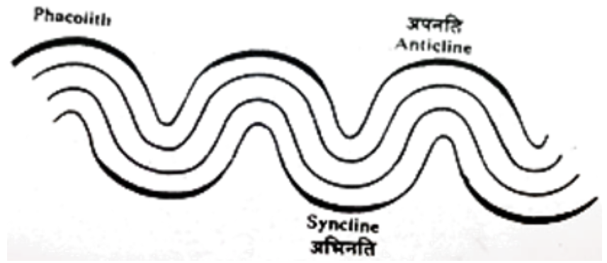
- Phacolith –
- During a volcanic eruption, when lava solidifies in a wavy or undulating shape, the resulting structure is called a Phacolith.
- In intrusive igneous formations, magma accumulates along the crests (anticlines) and troughs (synclines) of folded rock layers, forming layered or wave-like structures.
- These phacoliths are connected to magma chambers through a specific conduit.
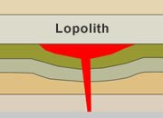
- Lopolith –
- When magma accumulates in shallow, concave-shaped depressions, it forms a basin-like structure, known as a Lopolith.
- Example: Lopolith structures are found in South America.
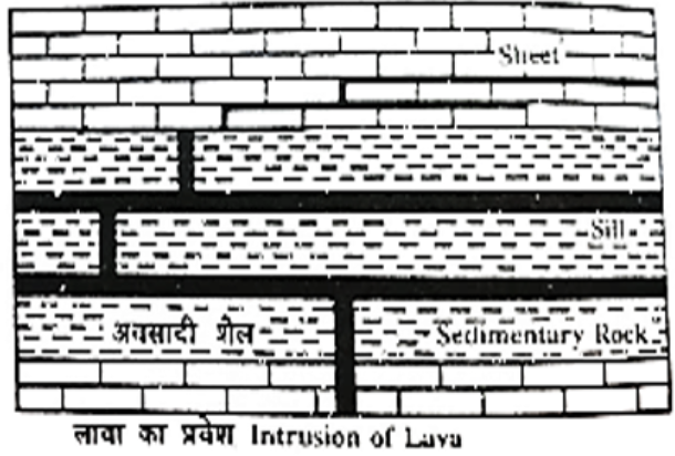
- Sill –
- When magma intrudes between the layers of sedimentary rocks and spreads parallel to the bedding planes, it forms a Sill.
- Sills are thick, but when the thickness is less, they are called Sheets.
- Examples in India: Sills are found in Madhya Pradesh and Jharkhand.
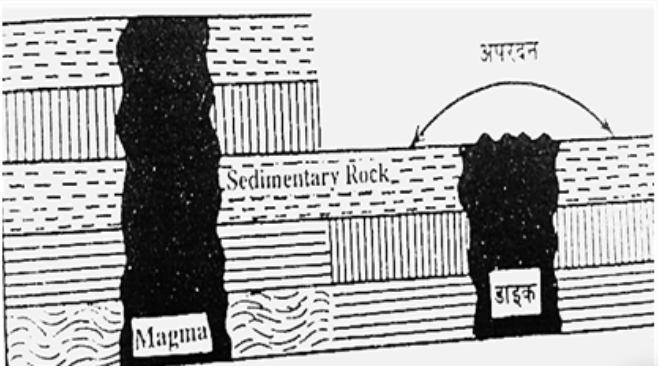
- Dyke –
- When magma does not spread horizontally but instead solidifies within vertical fissures, the resulting structure is called a Dyke.
- Their thickness ranges from a few centimetres to several metres and length ranges from a few metres to several kilometres. Some dykes are hard and some are soft.
- Due to erosion, dykes are found in three forms –
- Because the rock of the dyke is weaker than the surrounding rock, the upper part of the dyke gets eroded and a depression is formed.
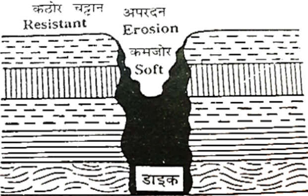
- Because the dyke rock is harder than the surrounding rock, the surrounding rock gets eroded and the dyke remains projected upwards.
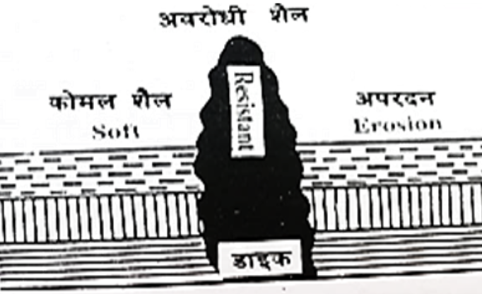
- If the dyke rock and the surrounding rock are equally hard or soft, then they erode equally.
Other topographies of volcanic regions
1. Geyser–
- A geyser is a hot water source that periodically erupts with steam and hot water from fissures and cracks in volcanic regions.
- During volcanic activity, hot water and steam escape intermittently through vents and cracks in the Earth’s crust. This phenomenon is called a Geyser.
- Old Faithful Geysers in Yellowstone Park of America, Iceland and New Zealand are the three main geysers of the world.
- Based on the amount of hot water and steam emitted from the geyser, it is divided into two categories –
- Pool type geyser–These geysers emit large amounts of hot water and steam due to wide vent openings. The eruption is intense, preventing mineral deposits from accumulating around the vent.
- Nozzle type geyser– These geysers emit lesser amounts of hot water and steam due to narrow vent openings. Their eruption is weaker, allowing mineral deposits to accumulate around the vent, forming a cone-like structure.
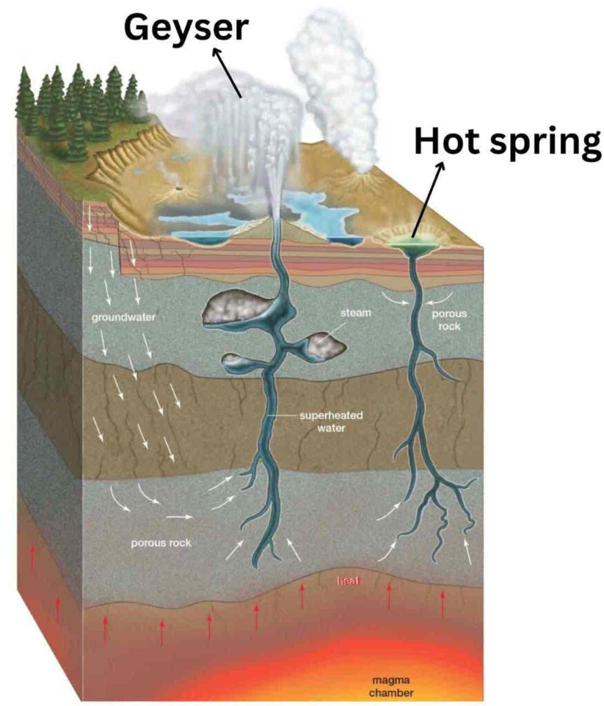
2. Hot spring
- Hot springs and geysers are similar, but they have some key differences:
- Hot Springs (Thermal Springs): Hot water and steam continuously emerge without intervals.
- The height of escaping steam and water is low.
- Geysers: Hot water and steam erupt intermittently, at regular intervals.
- The steam and water shoot up to a greater height.
- Hot springs are commonly found in volcanic regions, but they also exist in non-volcanic areas due to the presence of radioactive materials in rocks.
- Examples in India: Rajgir and Munger-Sita Kund (Bihar).
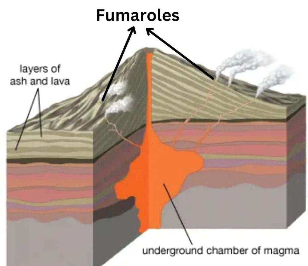
3. Fumaroles–
- When a volcano becomes inactive, the release of lava, ash, and fragmented materials stops. However, hot steam and gases continue to escape from the volcanic vents, appearing like smoke from a distance. These vents are called “Fumaroles” or “Steam Vents.”
- Characteristics of Fumaroles:
- The temperature of the escaping steam is very high.
- Along with steam, gases such as carbon dioxide, hydrogen sulfide, and nitrogen are also released, but steam is the dominant component.
- Solfataras (Sulfuric Fumaroles) – Fumaroles with a high sulfur content are known as “Solfataras” or “Sulfurous Steam Vents.”
- Example: Solfatara near Naples, Italy.
- Notable Fumarole Field: “Valley of Ten Thousand Smokes” near Mount Katmai, Alaska.
Note –
- When lava flow is very low, it is called a Hornito.
- Pyroclasts (volcanic fragments) are also known as Tephra.
- When water from deep underground mixes with magma and erupts along with it, this water is called Juvenile Water.
World and India distribution of volcanoes
- On the basis of plate tectonics, 80 percent of volcanoes are found on destructive boundaries, 15 percent on constructive boundaries and the remaining 5 percent in the inner parts, which are divided into different volcanic belts as follows:-
The following are the major volcanic belts of the world:
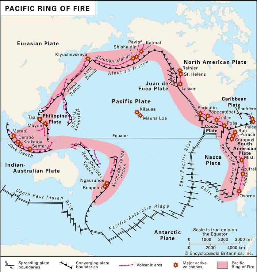
1. Circum Pacific Belt
- Volcanoes are located in the region of the converging and diverging plate boundaries.
- Most volcanoes, more than two-thirds, are found in the Pacific Ring of Fire.
- The four major conditions of occurrence of the earthquakes are present here ie. ground bounding waters, new fold mountains, volcanic regions, divergence of plate boundaries.
- Volcanoes are found in a large chain on the island arcs on both the coastal parts (east and west coast) of the Pacific Ocean. This chain of volcanoes is called the Pacific Ring of Fire.
- This volcanic belt extends from Mount Erebus (Antarctica) through the Andes Mountains of South America, the Rocky Mountains of North America, Alaska, Eastern Russia, Japan, and the Philippines, eventually merging with the Mid-Oceanic Belt.
- Notable volcanoes in this belt include: Mount Fuji (Japan), Mount Taal (Philippines) , Chimborazo (Central America) ,Mount Shasta and Mount Rainier (USA)
- The world’s highest active volcano, Cotopaxi (Ecuador), and the world’s highest volcano, Ojos del Salado (Chile), are also located in this belt.
Note – Ring of Fire
- The “Ring of Fire” is a vast region affected by earthquakes and volcanic activity in the Pacific Ocean, stretching over 40,000 km in a horseshoe shape.
- Most of the world’s earthquakes and volcanoes (both active and dormant) are located in this region, which extends along the eastern and western coasts of the Pacific Ocean.
2. Mid Continental Belt–
- In this region, volcanic regions are located in the convergence zone of the Eurasian, African and Indian plates.
- It has two branches- the first branch goes through the Atlantic Ocean to the Western Islands and the second branch goes through Spain, Italy and moves towards the Himalayas and merges with the Pacific Ocean belt in the south.
- The volcanoes of the Mediterranean Sea also fall in this belt.
- There is no volcanic activity in the Himalayan region of this belt because the displacement of plates in this region is not at the depth required for volcanic activity.
- Stromboli, Vesuvius, Etna and volcanoes of the Aegean Sea, Iran’s Damavand, Koh Sultan, Ararat of Armenia, Barren Island volcano of India.
3. Mid Oceanic Belt–
- In the Atlantic Ocean, this S-shaped volcanic belt extends from Iceland in the north to Antarctica in the south, following the Mid-Atlantic Ridge.
- Volcanic activity occurs due to the divergence of tectonic plates, leading to the formation of the Mid-Atlantic Ridge.
- Notable volcanic regions in the Atlantic Ocean:
- Northern Atlantic: Lesser Antilles, Azores Islands
- Southern Atlantic: Saint Helena, Ascension Island
- Iceland: Hekla, Katla, and Laki Volcanoes
4. Intraplate Volcanism:
- Volcanic activity also occurs within tectonic plates, away from plate boundaries.
- One such volcanic chain starts from the Hawaiian Islands and extends northwestward to Kamchatka.
- Intraplate volcanic activity occurs not only in oceanic plates but also within continental plates, such as: Northwestern USA , Parana region of Brazil and Paraguay , East African Rift Valley
- Cause of Intraplate Volcanism – Hot Spots:
- Hot spots are mantle plumes where hot magma rises rapidly, piercing through the lithosphere and forming volcanic structures on the surface.
- Hot spots remain fixed, while tectonic plates move over them, resulting in the formation of a chain of volcanoes, where: Older volcanoes are found at one end Newer volcanoes are found at the other end . Example: Hawaiian Islands.
5. East African Belt
- This belt extends from Israel in the north to the Red Sea in the south and through the East African Rift Valley to Madagascar.
- Elgon, Tibesti and Kilimanjaro are parts of this belt.
Note –Mount Cameroon (Mt. Cameroon): West Africa’s only active volcano.
Distribution of volcanic zones in India
- There is no volcano in the Himalayan region.
- Barren Island: Located 135 km north-east of Port Blair, this island was active in 1991 and 1995.
- Narcondam Island: Located in the Andaman and Nicobar Islands, this volcano is probably extinct. The wall of its crater has been completely destroyed.
Although at present there is no active volcano anywhere in the mainland of India, in the past there have been many volcanic eruptions in various areas. Such areas are as follows:
- Dalma region – It can be called the oldest volcanic region of India. Volcanoes erupted in this region during the Dharwad period. This region is called Dalma region after the name of Dalma range of Bihar (near Jamshedpur).
- Cuddapa, Bijawar and Gwalior region – Volcanoes erupted in all these three regions during the Cuddapah period.
- Malani and Kirana region – Malani range is located near Jodhpur and Kirana hill is situated on the northern end of Aravali. Volcanic eruption took place here in the Vindhyan period.
- Low Himalayan region – It includes Pir Panjal range, upper valley of Sutlej, Garhwal, Nainital etc., where volcanic eruptions took place in Palaeozoic era.
- Rajmahal and Abor hill region – This region is spread from Bihar to Assam. Volcanic eruption took place here in the Jurassic period.
- Deccan Lava Field – This eruption occurred at the end of the Cretaceous Period.
Effects of volcanic activity
Positive effects
- Fertile Soil for Agriculture: Black soil (formed from the weathering of basaltic lava) is highly fertile and suitable for cotton cultivation. Volcanic ash and dust enrich farmlands and orchards, making them highly productive..
- Acts as a Natural Safety Valve: Volcanic eruptions release internal pressure from the Earth’s interior, reducing the risk of major geological disasters.
- Volcanic activity provides valuable information about the Earth’s internal composition and processes.
- Various volcanic landforms (plateaus, mountains, calderas) are economically and ecologically significant.
- Formation of igneous rocks.
- Volcanic rocks contain rich mineral deposits. Example: The Kimberlite rocks of South Africa, remnants of ancient volcanoes, are a major source of diamonds.
- Sulfur-rich hot springs found in volcanic regions help in treating skin diseases.
- Geothermal Energy Production: Steam from volcanic regions is used to generate geothermal energy, a renewable energy source. Countries utilizing geothermal energy: USA, Russia, Japan, Italy, New Zealand, Mexico
- Potential geothermal sites in India: Puga Valley (Ladakh), Manikaran (Himachal Pradesh)
- Volcanoes attract tourists due to their natural beauty and uniqueness. Many volcanic sites have been designated as National Parks. Example: Yellowstone National Park (USA).
Negative Effects
- Destruction of Cultural and Natural Landscapes: Flowing lava, gases, and volcanic materials damage human settlements, historical sites, and ecosystems.
- Lava flows destroy forests, farmlands, and disrupt ecosystems, leading to loss of biodiversity.
- Underwater volcanic eruptions cause oceanic disturbances, leading to massive destruction of marine life.
- Harmful and toxic gases released during eruptions cause acid rain, which adversely affects human health, crops, and buildings.
- Submarine volcanic eruptions and collapse of volcanic structures can trigger tsunamis. Example: 2018 Sunda Strait Tsunami (Indonesia).
- Large-scale volcanic eruptions release ash clouds that spread across vast areas, blocking sunlight, reducing global temperatures, and causing famine.
- Volcanic gas plumes can disrupt air travel for weeks. 2010 eruption of Iceland’s stratovolcano disrupted air travel in Europe for weeks.
Tsunami
- Tsunami is a Japanese word that means “Harbor Wave.”
- Tsunami waves are high-energy, long oceanic waves. They are generated due to extremely intense earthquakes (greater than 7.0 on the Richter scale) caused by faults and plate collisions in the oceanic floor.
- Tsunami waves can also be triggered by underwater landslides, coastal landslides, and volcanic eruptions occurring on the ocean floor, which cause high-intensity earthquakes.
- In deep oceans, tsunami waves have greater wavelength and lower wave height. However, as they approach the shore, their wavelength decreases, and the wave height increases. This process is known as the “Shoaling Effect.”
- The speed of tsunami waves is maximum in deep oceans, while it is minimum near coastal regions. Tsunami waves are considered “shallow water waves” and are different from tidal waves.
- The highest occurrence of tsunamis is in the Pacific Ocean. As a result, this region suffers the most significant loss of life and property due to tsunamis.
- On December 26, 2004, a powerful tsunami was generated in the Indian Ocean due to an earthquake, causing massive destruction and loss of life. Similarly, in March 2011, a strong tsunami occurred in the western Pacific Ocean, which caused severe devastation in Japan.
| DOART – (Deep Ocean Assessment and Reporting of tsunami) – This is a specialized technology designed to detect tsunamis and rapidly transmit warnings to affected regions.Purpose: Helps in early detection of tsunamis. Enables timely disaster management to minimize damage and loss of life.Main Components:Tsunameter: Detects seismic activity under the ocean floor and measures earthquake intensity.Signaling and Communication System: Sends warning alerts to all potentially affected coastal areas. |
| Volcanism and Acid Rain:Harmful volcanic gases such as sulfur dioxide (SO₂), carbon dioxide (CO₂), and hydrogen fluoride (HF) pose serious threats to humans, animals, agriculture, and property.Local Effects:Sulfur dioxide (SO₂) released from volcanoes can cause acid rain and air pollution, especially in downwind areas.Global Effects:Large volcanic eruptions that release high amounts of sulfur aerosols into the atmosphere can lower Earth’s surface temperature.These aerosols also contribute to ozone layer depletion, increasing exposure to harmful UV radiation. |
Volcanoes: Types, distribution and their effects / Volcanoes: Types, distribution and their effects / Volcanoes: Types, distribution and their effects / Volcanoes: Types, distribution and their effects / Volcanoes: Types, distribution and their effects / Volcanoes: Types, distribution and their effects /
Connection between earthquakes and volcanoes
- The Plate Tectonics Theory explains the interconnection between earthquakes and volcanic activity.
- During volcanic activity, magma breaks through the Earth’s crust to reach the surface. This rupturing of layers leads to the generation of earthquakes. Therefore, all volcanic regions are also earthquake-prone areas.
- However, not all earthquake-prone areas experience volcanic activity. This is because:
- In some cases, subducted plates do not reach sufficient depths to melt and form magma.
- Volcanic activity is mainly associated with convergent (except continental-continental collision) and divergent plate boundaries, whereas earthquakes occur at all types of plate boundaries.
- Conclusion:
- All volcanic regions experience earthquakes.
- Not all earthquake-prone regions experience volcanic activity.
Major volcanoes of the world
| Name | Country |
| Ojos del salado | Argentina–Chile |
| Arenal, Irazu | Costa rica |
| Krakatoa | Indonesia |
| Cotopaxi, Chimborazo | Ecuador |
| Kilauea, Mauna Loa | Hawaiian Islands |
| Kilimanjaro | Tanzania |
| Mount Cameroon | Cameroon (Africa) |
| Mount Lamington | Papua New Guinea |
| Mount Etna | Sicily (Italy) |
| Vesuvius | Italy (Bay of Naples) |
| Stromboli | Lipari Islands (Italy) |
| Mount Erebus | Antarctica |
| Mount St. Helens, Mount Rainier, Mount Shasta, Mount Hood, Lassen Peak | United States America |
| Katmai | Alaska |
| Mount Pinatubo, Mount Taal, Mayon | Philippines |
| Mount Kelimutu, Semeru, Merapi | Indonesia |
| Fujiyama | Japan |
| Mount Popa | Myanmar |
| Demband, Alborz | Iran |
| Takana | Guatemala and Mexico |
| Hekla and Laki | Iceland |
| Kolyma | Mexico |
| Sabancaya | Peru |
| Kinabalu | Malaysia |
| Aconcagua | Argentina |
Volcanoes: Types, distribution and their effects / Volcanoes: Types, distribution and their effects / Volcanoes: Types, distribution and their effects / Volcanoes: Types, distribution and their effects / Volcanoes: Types, distribution and their effects / Volcanoes: Types, distribution and their effects / Volcanoes: Types, distribution and their effects / Volcanoes: Types, distribution and their effects / Volcanoes: Types, distribution and their effects / Volcanoes: Types, distribution and their effects /
