
In World Geography, earthquakes are sudden vibrations in the Earth’s crust caused by tectonic or volcanic activity. Their types, global distribution, and impacts on life and landscapes are crucial for understanding and managing their effects.
Previous Year Question
| Year | Question | Marks |
| 2016 S. E. | What is the epicentre? | 2 M |
| 2016 | Describe the distribution of earthquakes in the world. | 10 M |
| 2023 | M |
Earthquakes: Types, distribution and their effects
Earthquake
- Earthquake is the outward flow of the earth’s internal energy recorded in the form of waves. Earthquake can be defined as a sudden shock in the earth’s crust due to the movement of plates, which results in the sudden release of energy and the formation of seismic waves.
- According to F.J. Monkhouse, the progression of devastating elastic waves in all the directions, due to the process of movement and adjustment of earth’s layers is termed as ‘Earthquake’.
- The earth’s surface is always changing due to endogenous and exogenous forces.
- Sudden vibrations on any part of the earth’s crust caused due to endogenetic forces of the earth, is called Earthquake”.
Causes of origin of earthquake
A. Natural causes –
- Plate tectonic activities – Different plates at their margins converges, diverge or transform. During these processes, the movements of plates causes earthquakes. earthquakes of High intensity occur at convergent plate, moderate and low intensity earthquakes occur at divergent plate edges .
- Volcanic eruption – During the volcanic eruption, the trapped gases pushes and gushes out with intense heat. This causes vibration on earth’s surface. Etna, Krakatoa, Vesuvius, volcanoes caused devastating earthquake during their eruptions.
- Fault formation – Due to the tension and contraction caused due to endogenetic forces, the rocks are cracked or fractured, which is called Faults. Earthquakes occur during such processes.
- Elastic Rebound Theory – According to Prof. F.S. Reed rocks are like elastic, in nature and can be stretched upto a limit, after this it breaks. The broken parts regions it previous positions, which causes earthquakes.
- Isostatic adjustment – Isostasy is the balance between the high and low regions of the earth. When this balance is disturbed by erosion and deposition, an attempt is made to restore it by structural activities, which leads to earthquakes. Such earthquakes occur more in mountainous and coastal areas.
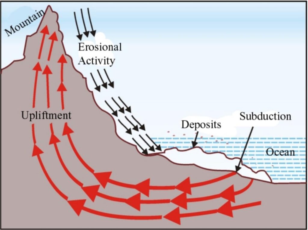
Isostatic Adjustment
- Contraction of the Earth’s crust – Scientists believe that the cooling of the earth causes contraction of the crust, and sudden contraction causes earthquakes. Dana, Beaumont and Jeffries are supporters of this view.
- Dispersion of gases- When water beneath the earth turns into vapour or gases due to extreme heat and as their intensity increases, it try to move upwards, then vibrations are generated in the earth’s surface due to collision, which leads to a common earthquake.
B. Anthropogenic causes-
Earthquakes which are not caused by natural causes but by man-made activities such as construction of big buildings, construction of reservoirs and dams, digging of tunnels and mines and testing of bombs etc. are called “unnatural earthquakes” or “man-made earthquakes”.
- Dam construction: Under dam construction, a reservoir is constructed in which due to the extra weight of water, the rocks present at the bottom sometimes slip and break, causing earthquakes. For example, India’s Koyna earthquake in 1967.
- Mining – Sometimes due to excessive mining, the roof of underground mines collapses, which causes vibrations in the surrounding areas and earthquakes occur.
- Explosions – Mild tremors of earthquakes are also felt due to nuclear and chemical explosions.
Classification of Earthquakes
Based on the general characteristics of earthquakes, they can be classified into the following parts –
1. Based on the factors involved in the origin of earthquake
A. Natural earthquakes – Earthquakes originate from external or internal forces of the earth. Natural earthquakes are again classified into four parts –
- Volcanic earthquakes- The intensity of such earthquakes depends on the intensity of volcanic eruption. Earthquakes usually occur in volcanic areas. For example, the Krakatoa volcanic earthquake of 1883.
- Fault earthquakes- Caused by faulting in the Earth’s crust, leading to crustal displacement and resulting in intense and severe earthquakes. The depth of earthquake occurrence ranges from 4.8 km to 24 km inside the Earth. Example: The 1872 California earthquake.
- Isostatic earthquakes – These earthquakes are caused due to imbalance in the isostatic balance of the earth. These types of earthquakes occur in the areas of young fold mountains like Himalayan Region, earthquakes in Hindukush and Nepal in 2015.
- Tectonic earthquakes – These are structural earthquakes, which are generated by tectonic movements of the earth’s crust such as tension, compression etc. They are generated near the surface. For example – California earthquake.
- Plutonic earthquakes – Earthquakes generated at a depth of 240 km to 672 km from the Earth’s crust are called “plutonic earthquakes”. Due to the fact that subterranean earthquakes are generated at great depths, they rarely occur on the surface.
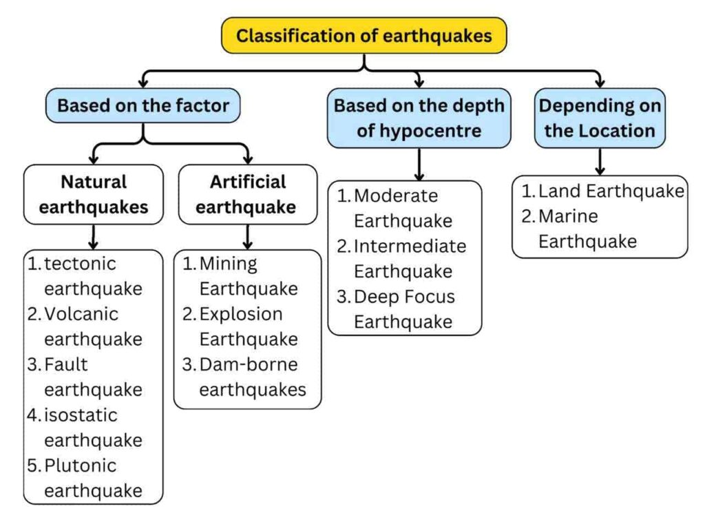
B. Artificial or unnatural earthquake–
- Mining Earthquake – Earthquakes that occur due to collapse of roofs of underground mines are called Mining Earthquakes.
- Explosive earthquakes – Earthquakes also occur due to chemical and nuclear explosions, which are called explosion earthquakes.
- Dam-borne earthquakes – Due to the excess weight of water in the reservoir created along with the dam, the rocks at the bottom of the reservoir slip and break and such earthquakes are called dam-borne earthquakes or reservoir-borne earthquakes.
2. Classification based on the location of earthquake origin-
- According to Gutenberg and Ritter, “The process of generation of vibrations is the same at every depth.”
- Oldham studied the earthquakes of Italy and concluded that more than 90% of the earthquakes on Earth occur at a depth less than 8 km from the Earth’s surface, 8% earthquakes occur at a depth of 8 km to 30 km and the remaining earthquakes occur at greater depths.
Depending upon the depth of the earthquakes, they are classified into the following parts –
- Normal Earthquakes –
- The focus is located at a depth of 0 to 50 km.
- Most earthquakes fall under this category.
- Cause significant damage to life and property.
- Low magnitude but high intensity – highly destructive earthquakes.
- Intermediate Earthquakes –
- The focus is located at a depth of 50 km to 250 km.
- Moderate magnitude and intensity.
- Deep Focus Earthquakes –
- The focus is located at a depth of 250 km to 700 km.
- Also known as “Plutonic Earthquakes.”
- Least frequent but high magnitude.
3. Classification based on status –
- Terrestrial earthquakes – Those earthquakes that occur on land. The number of earthquakes is more than marine earthquakes. Example – Earthquakes in the mid-continental belt.
- Marine Earthquakes-Earthquakes that occur in the depths of the ocean. These earthquakes generate extremely destructive sea waves in the ocean. These waves are called “tsunamis”. These waves cause more damage to coastal areas. The city of Fukushima was completely destroyed by the tsunami caused by a severe earthquake near Japan’s Honshu Island in March 2011.
Seismology
- The instrument installed at the earthquake centre and epicentre by which seismic waves are calculated or the intensity of waves is measured is called earthquake recording instrument or seismograph and the science or subject in which the waves recorded by seismograph are studied is called seismology or seismology.
- With the help of seismographs, we get information about the speed of seismic waves, their origin and the areas affected by the earthquake.
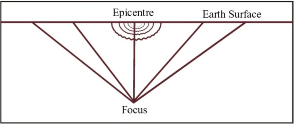
- Earthquake focus/hypocenter – The place in the earth’s crust where an earthquake originates. The place of release of energy.
- Epicentre – The point on the Earth’s surface directly above the earthquake’s focus (hypocenter). It is the first location to experience seismic waves. This region is the most affected by the earthquake because the seismic wave intensity is highest here.
- Seismic waves reach the epicenter and propagate around the center in a circular or elliptical form. As these waves move away from the epicenter, the intensity of these waves decreases, which also reduces the effect of damage.
- The lines joining the areas of equal impact (based on the amount of damage) are called isoseismal lines. Their shape depends on the epicenter. Generally, due to the epicenter being in the form of a long line, the shape of the isoseismal lines is oval.
Seismic Waves-
- Seismic waves are energy waves that travel through the layers of the Earth.
- They follow the path created by vibrations during an earthquake.
- The refraction and reflection of seismic waves are used to study the Earth’s internal structure..
- When an earthquake originates from its focus, seismic waves move upward and first reach the epicenter, where their intensity is recorded using a seismograph.
- Based on the calculation and study of seismic waves, three main phases of earthquake waves are observed as they move away from the epicenter.
- First Preliminary Tremors – These are the initial weak tremors generated during an earthquake. Sometimes, these tremors are too weak to be recorded by a seismograph.
- Second Preliminary Tremors – Occur immediately after the first tremors. Stronger than the first tremors and can be recorded by instruments.
- Main Tremors – The final and most intense tremors. These cause the most movement and destruction.
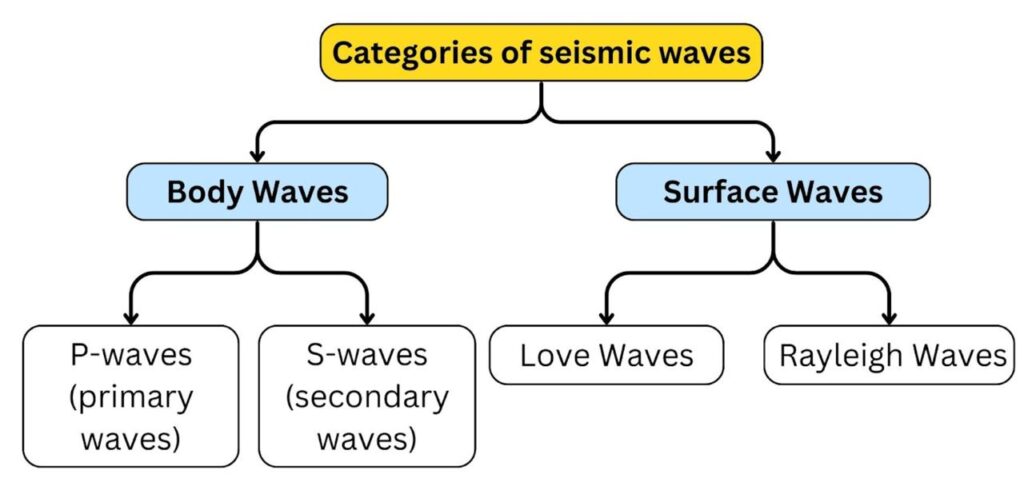
A. Body Waves
These waves are generated due to the release of energy from the focus and travel in all directions within the Earth.
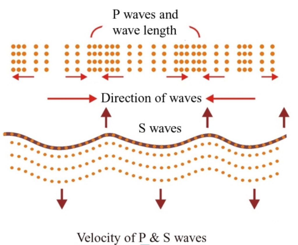
1. Primary or Longitudinal Waves –
- P-waves are the first seismic waves to be generated during an earthquake.
- They travel outward from the earthquake’s origin (focus) and are the first to be felt on the Earth’s surface.
- They are Longitudinal Waves. The particles move back and forth in the direction of the wave’s movement (similar to sound waves).
- Also Known as Compression Waves. They move by compressing and expanding the material they pass through, causing variations in density.
- Fastest seismic waves with the highest velocity but lower intensity.
- Recorded first on a seismograph.
- These waves pass through all three mediums – solid, liquid and gas.
- Their speed depends on the elasticity of the medium: Solid > liquid > gas.
- Speed - 6 to 13 km per second [average speed 8 km per second]
2. Secondary or Transverse Waves–
- These waves arrive after Primary (P) waves, hence called Secondary or Shear Waves.
- They are transverse waves ,meaning particle motion is perpendicular to the direction of wave propagation. S waves produce vibrations in the vertical plane at right angles to the direction of the waves so they create crust and troughs in the material through which they pass – most destructive.
- Similar to Light and Water Waves: Their motion resembles light waves or ripples on water surfaces.
- The speed of the secondary wave is less than that of the primary wave and these waves travel only in solid medium and cannot pass through liquid medium.
- Higher Intensity than P-Waves but Lower than Surface Waves (L-Waves).
- Also Known as “Distortion Waves” (listortiona wave).
- Speed - 4 to 7 km per second
B. Surface Waves
- These waves are generated when body waves come into contact with the surface. Surface waves travel only along the Earth’s surface.
- Surface waves are the slowest but the most destructive because most of their energy affects the surface.
1. Love Waves –
- Named after scientist Edward H. Love.
- They move only in a horizontal direction (side-to-side motion).
- Cause maximum damage near the surface layers of the Earth.
- Speed is lower than P and S waves but has the highest intensity, making them the most destructive.
- Travel the longest distance on the Earth’s surface and spread outward from the epicenter.
- Affect only the upper part of the Earth’s crust, with a convex travel path.
- Speed: 1.5 – 3 km per second.
2. Rayleigh Waves-
- Rolling Motion: The particles move in a retrograde elliptical motion (opposite to the wave’s travel direction).
- This motion resembles ocean waves, causing both vertical and horizontal ground displacement.
- Their speed depends on the material properties of the Earth’s surface.
Rocks of different densities are found in the Earth’s crust, so the velocity of primary, secondary and surface waves is not the same everywhere. Based on the difference in velocity, these waves are classified into three parts –
(i) P and S waves –
- These waves have the highest velocity. These waves also travel in the core part of the earth.
- As these waves move downwards, their velocity increases. But S waves cannot travel in liquid medium.
- In the lower layer of the earth, the speed of P is 7.8 km/sec and the speed of S is 4.35 km/sec.
(ii) Pg and Sg waves –
- Pg and Sg waves were discovered from the earthquake that occurred in the Kulpa Valley of Yugoslavia in 1909.
- These waves are similar to P-S waves but their speed is less than that of P-S waves.
- These waves usually travel in the upper layer of the earth.
- The speed of Pg waves is 5.4 km/sec and the speed of Sg waves is 3.5 km/sec.
- Due to this motion, these waves can propagate only through granite layers.
- This suggests that the upper crust beneath the thin sedimentary layer is composed of granite.
(iii) P* S* waves –
- Conrad discovered P* and Jeffries discovered S* waves.
- P* and S* waves travel in the intermediate layer of the earth.
- The speed of P* is between P and Pg and the speed of S* is between S and Sg.
- The speed of P* is 6.0 to 7.2 km/sec and the speed of S* is 3.5 to 4.0 km/sec.
- By studying them, we get information about the intermediate layer made of basalt located beneath the earth’s crust.
Seismic shadow zone
- The seismic shadow zone lies between 105º and 145º from the earthquake epicenter, where no seismic waves are recorded.
- Seismographs record both ‘P’ and ‘S’ waves at any distance within 105° from the earthquake epicenter.
- Seismographs beyond 145° from the epicenter record only the arrival of ‘P’ waves and do not record ‘S’ waves. The zone between 105° and 145° from the earthquake epicenter (where no seismic waves are recorded) is the shadow zone for both types of waves.
- ‘S’ waves do not reach the entire area beyond 105°. The shadow area of ’S’ waves is more extensive than the shadow area of ’P’ waves. The shadow area of ’P’ waves appears as a band around the earth from 105° to 145° of the earthquake epicenter.
- The shadow area of ’S’ waves is not only larger in extent, but it is also more than 40 percent of the earth.
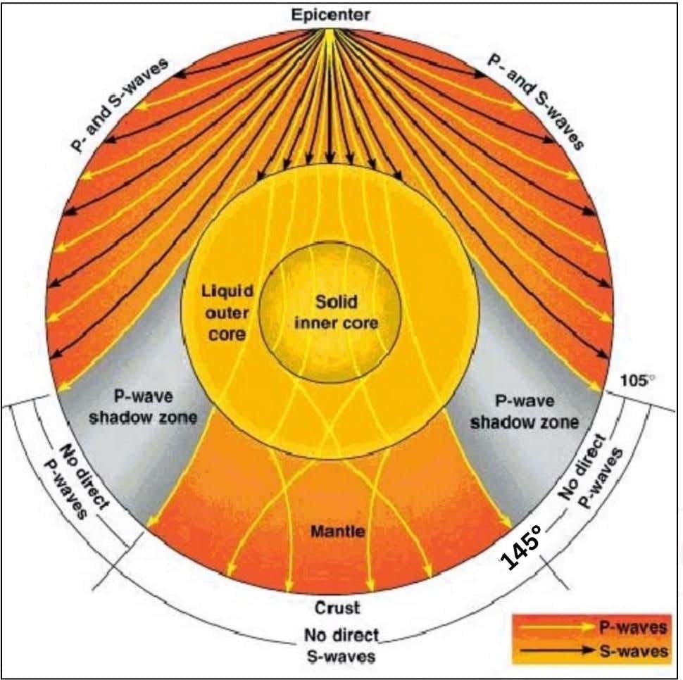
- The study of the travel path and velocity of seismic waves provides information about the Earth’s internal structure.
- Seismic waves travel in straight lines through uniform-density regions but follow a curved path near the earthquake’s focus.
- This confirms variations in density within the Earth’s interior, causing the waves to bend.
- As density increases towards the Earth’s core, P and S waves bend inward toward the surface.
- Since S-waves cannot travel through liquid, they disappear at depths greater than 2,900 km (the Earth’s outer core), proving that this region is in a liquid state surrounding the inner core.
Intensity and Magnitude of Earthquakes and Measurement
- Seismic waves are measured by an instrument called ‘seismograph’.
- The intensity of an earthquake is recorded in terms of the movement in the ground at a place and its effect on humans.
- The destruction caused by an earthquake is assessed on the basis of the damage caused to buildings, dams and other objects.
- The magnitude of an earthquake is measured in terms of the energy released by it. It depends on the frequency, amplitude, acceleration etc. of the seismic waves.
Richter magnitude scale
- Charles F. Richter developed the Richter magnitude scale (ML) in the 1930s to measure the magnitude (amount of energy released) of earthquakes.
- Beno Gutenberg modified the Richter scale in 1965.
- It is a logarithmic scale. There are no maximum and minimum limits in this scale.
- Due to various limitations of the ML scale, the “moment magnitude scale” (Mw) is now used in seismology.
- Both scales are logarithmic and have almost similar numerical values.
- The Moment Magnitude Scale (Mw) is now often referred to as the Richter scale.
- On the Richter scale, an increase of one unit corresponds to an earthquake that is 10 times more intense and releases 31.6 times more energy than the previous unit.
- A one-unit increase means ~32 times more energy release.
- A two-unit increase means ~1,000 times more energy release.
- For example, a 7.0 Mw earthquake releases about 32 times more energy than a 6.0 Mw earthquake and about 1,000 times (32 x 32) more energy than a 5.0 Mw one.
- The Richter scale is only effective for regional earthquakes with a magnitude less than 5.0. The Moment Magnitude scale is more effective for larger earthquakes.
Mercalli scale
- Apart from the Richter scale, the modified Mercalli scale is also used to measure the intensity and impact of earthquakes.
- Mercalli scale [developed in 1902] is named after its developer ‘G. Mercalli’.
- Mercalli scale was modified by Wood and Newman in 1931. Hence Mercalli scale is now called modified Mercalli scale.
- In this scale, an earthquake is measured on the basis of damage caused by it i.e. impact instead of its intensity. This scale is used less because it is considered less scientific than Richter.
- It is an experience based scale and its measurement is from 1 to 12.
| Richter scale | Mercalli Scale |
| Numbers from 0 to 10. | Numbers from 1 to 12. |
| It is an ‘open-ended scale’ meaning that if in the future an earthquake occurs which releases more energy, the value of this scale can be increased. | ‘Close-ended’ scale. |
| It is a logarithmic scale, in which the amplitude of the waves increases 10 times for every increase in magnitude. This means that each level of the Richter scale is 10 times stronger than the previous level. | This is a simple linear scale. |
| Richter is a quantitative scale, hence it has objectivity. | This is a qualitative scale which has subjectivity. |
Factors affecting the intensity of an earthquake
Following are the details of the factors affecting the intensity of an earthquake:
- Rocky structure – In rocky areas which have high density, the intensity of earthquake is also high, whereas in marshy areas the intensity is comparatively less.
- Intensity of waves – As the intensity of waves increases, the intensity of earthquake increases and as the intensity decreases, it decreases.
- Depth of earthquake origin – The lesser the depth of the earthquake origin, the greater will be the intensity of the earthquake. Hence, earthquakes in areas with less depth of origin are more destructive than earthquakes with deep and medium depth of origin.
- Environment – Where there are trees, plants and natural vegetation (forests) in large numbers, the intensity of earthquake is less. As a result, the danger of destruction is also less. But the increase in deforestation creates chaos in isostasy, which leads to increase in seismic events and intensity.
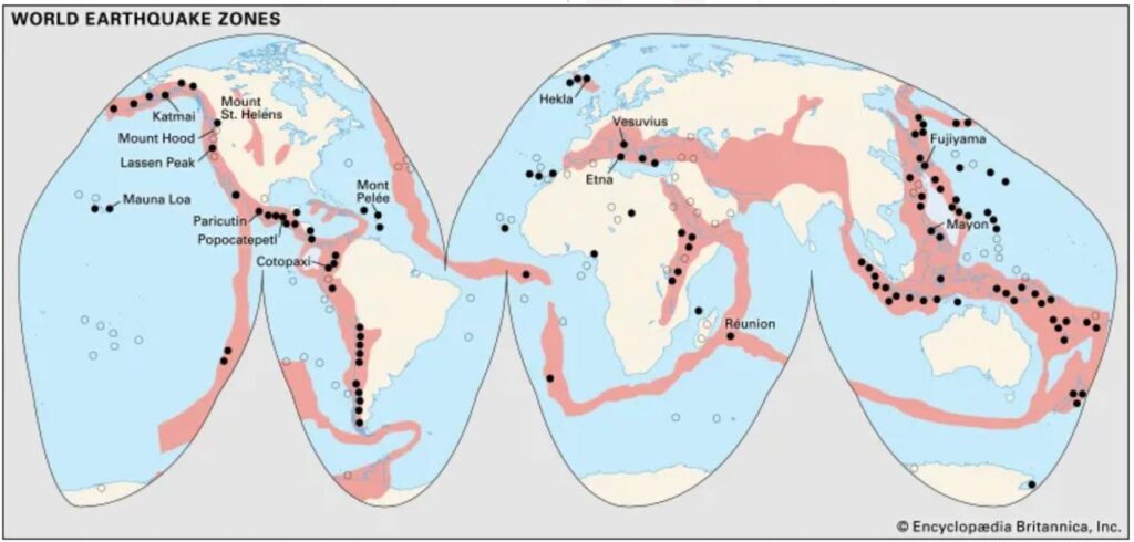
World Distribution of Earthquakes
World description of earthquake-
Most of the earthquakes in the world occur in newly folded mountains, volcanic areas, coastal areas, these are the areas where isostasy is chaotic or the crust is weak. Earthquakes occur at the edges of the plates. The following are the earthquake belts in the world –
1. Pacific Coast Belt-
- The world’s most extensive earthquake zone. 2/3rd (about 63%) of the world’s earthquakes occur here.
- Divided into two branches – the first branch extends from Asia’s Kamchatka peninsula to Kurile and Japan, Philippines and the eastern islands, and the second branch goes through Chile, Peru, Central America and reaches Alaska.
- Earthquakes here are directly related to the convergence of plates, faulting and volcanic activity.
- This belt is located around the Pacific Ocean in the islands and continents like the circumference of a circle. It is also called the ring of fire.
- Here four major conditions of earthquakes are found – sea and land meeting area, new folded mountain area, volcanic area, destructive plate, boundary divergence area.
- In this belt, equilibrium earthquakes, tectonic earthquakes and volcanic earthquakes occur. All three types of seismic origin zones, deep, shallow and medium, are found here.
- For example – mild and severe earthquakes occurring in Alaska, Japan, New Zealand, Chile, Philippines and mid-ocean region.
2. Mid Continental Belt–
- In this region, about 21 percent of the world’s earthquakes occur due to the convergence of plates, which are fault-based and equilibrium-based.
- This belt starts from Mexico and passes through the Atlantic Ocean, Mediterranean Sea, Alps and Caucasus and extends to the Himalayas and its adjacent areas.
- The earthquake-affected areas include the Himalayas of India and the hills of Myanmar and the Alps of Europe. This is also called the ‘Alpine Belt’ (Alps and Himalayas).
- The major earthquake-prone areas of this region are Portugal, Spain, Italy, Asia Minor, the Balkan Peninsula, Iran and Northern India, China and Myanmar.
3. Mid Atlantic Belt –
- This belt is located near the Mid-Atlantic Ridge. It starts from Bergen and Iceland in the north and extends till Bouvet Island in the south. One of its branches extends through the Nile Valley to the Great Rift Valley of Africa.
- Most of the earthquakes in this belt occur in the areas near the equator.
- Generally, low intensity earthquakes occur in this belt, which are caused by the formation of transform faults due to the divergence of plates and fissure volcanic eruptions.
4. Other regions – such as the Rift Valley region of East Africa, where mainly fault-based earthquakes occur, the Indian Ocean belt.
| Wadati-Benioff zone: earthquakes at convergent boundariesThe Wadati-Benioff Zone is the area where earthquakes commonly occur due to the subduction process. The most powerful earthquakes occur in this zone, often at convergent boundaries.The differential motion of plates in this zone produces many earthquakes, with focuses as deep as 700 km.The Wadati–Benioff region is formed when:1.Slip occurs along subduction thrust faults, such as the Himalayan region (Continental-Continental Convergent Boundary).2. Slip occurs along faults within the downgoing plate, such as oceanic-oceanic and continental-oceanic convergent boundaries. |
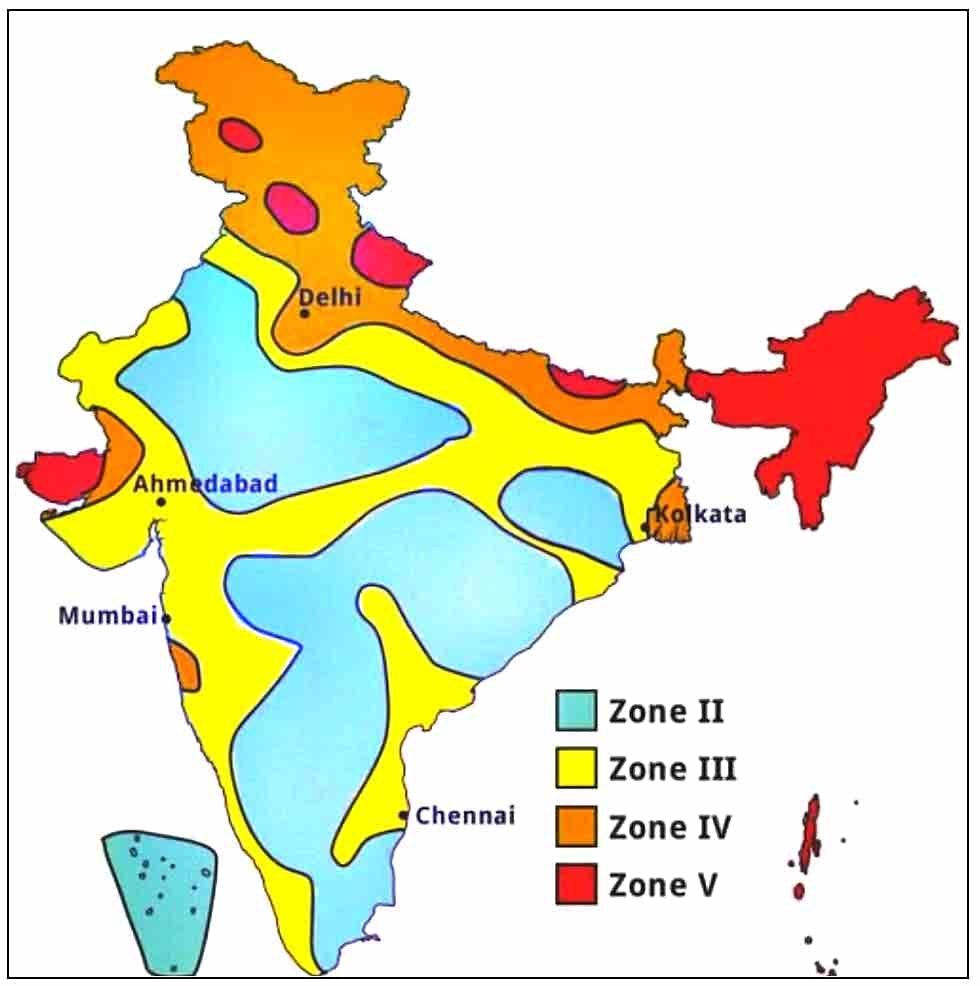
Earthquake distribution in India
- According to the latest seismic zone map prepared by the National Disaster Management Authority, about 59% of India’s land area is prone to moderate or severe earthquakes.
- This earthquake zone map divides India into five different zones based on the intensity of earthquakes and shows the places falling under these zones.
| Zone | Description | Place |
| Zone 5 | High Damage Hazard ZoneEarthquake Intensity: MSK IX (or more)Characteristics: Being a convergent plate boundary region, it is the most earthquake prone region in India. | North-eastern States, North Bihar, Uttarakhand, Himachal Pradesh(western part), Jammu and Kashmir, Kutch Peninsula, Andaman-Nicobar Islands. |
| Zone 4 | High damage risk zone Earthquake intensity: MSK VIII Features: High earthquake intensity due to proximity to zone-5. | Jammu & Kashmir, Himachal Pradesh, Uttarakhand, Delhi, Punjab, Haryana, Rajasthan, Uttar Pradesh (Northern part), Bihar (Northern part), Sikkim,West Bengal, Gujarat,Maharashtra (coastal area). |
| Zone 4 | Medium damage risk areaEarthquake Intensity: MSK VIICharacteristics: Earthquakes of moderate intensity. | Punjab, Haryana, Rajasthan, Uttar Pradesh, Bihar, Jharkhand, West Bengal, Orissa, Chhattisgarh, Madhya Pradesh, Gujarat, Maharashtra, Goa, Karnataka, Kerala, Tamil Nadu and Andhra Pradesh. |
| Zone 2 | Low damage risk zoneEarthquake intensity: MSK VI (or less)Features: Least earthquake prone zone of India. | Spread over about 46% of the area of India.Punjab, Haryana, Rajasthan, Uttar Pradesh, Gujarat, Madhya Pradesh, Orissa, most part of peninsular India and Lakshadweep. |
| Note-Zone 1 has also been included in Zone 2 by the Bureau of Indian Standards. So now there are four seismic zones in India. | ||
Earthquake in India 1 Comment –
- Maximum earthquakes occur in the Himalayan mountainous region of India because this region is situated on the convergent plate boundaries where the Indo-Australian plate is moving towards the Eurasian plate at the rate of 1 cm per year.
- The peninsular plateau region of India was till now considered to be safe from earthquakes because it is the oldest, most stable and mature landmass of India. But the earthquakes occurring in Maharashtra in the last few years have rejected this hypothesis.
- According to geologists, a fault is being formed in the Krishna- Bhima river area in the Latur-Osmanabad region of Maharashtra, due to which earthquakes are now occurring in this region.
- So now no region of India can be considered completely safe from earthquakes, but still peninsular India is less affected by earthquakes compared to other regions.
Effects of earthquakes
- Earthquakes cause both destructive and structural work.
- Structural work is less than destructive work.
Negative
- Huge loss of life and property. [Most damage is near the epicentre] Earthquake of 7.9 magnitude (Richter scale) on 26 January 2001 in Bhuj, Gujarat.
- Infrastructural damage, such as houses, dams etc. break down.
- Blockage in the path of rivers due to earthquakes, causing floods in nearby areas. Flood in Brahmaputra and its tributaries due to Assam earthquake in 1950.
- Problem of floods due to breaking of dams etc.
- Earthquakes in sea areas cause huge waves [tsunami] which cause heavy damage in coastal areas.
- Landslides in mountainous areas.
- Earthquakes cause formation of huge faults on the earth’s surface, which affects traffic, for example – Japan earthquake in 1891, California earthquake in 1906.
- Earthquakes can cause fires by damaging power supply lines or gas pipelines. The 1906 San Francisco earthquake caused more deaths from fires than from the earthquake itself.
Positives
- Formation of new islands or plains due to the rise of submerged land in sea areas.
- Formation of new topographies (like mountains, plateaus, valleys etc.) due to folding or faulting caused by earthquakes.
- Helpful in understanding the internal structure of the earth.
- Earthquakes cause large cracks on the earth’s surface from which minerals can be obtained.
- Volcanic eruption caused by earthquakes causes the spread of lava on the surface. This gives black soil which is useful for the cultivation of cotton and wheat.
Earthquakes: Types distribution and effects / Earthquakes: Types distribution and effects / Earthquakes: Types distribution and effects / Earthquakes: Types distribution and effects / Earthquakes: Types distribution and effects / Earthquakes: Types distribution and effects / Earthquakes: Types distribution and effects / Earthquakes: Types distribution and effects / Earthquakes: Types distribution and effects / Earthquakes: Types distribution and effects / Earthquakes: Types distribution and effects / Earthquakes: Types distribution and effects /Earthquakes: Types distribution and effect
