
Earth’s Structure and Geological Time Table is an important topic in World Geography that helps us understand the physical makeup and history of our planet. It explains the internal layers of the Earth and the division of Earth’s history into different geological eras and periods based on major events like the formation of continents and evolution of life.
Previous Year Question
| Year | Question | Marks |
| 2013 | What is the spring equinox? How does it happen? | 2 M |
| 2016 S. E. | Explain the divisions of the geologic timetable. | 10 M |
| 2016 | Discuss the characteristics of the Mesozoic Era of the geologic time table. | 5 M |
| 2018 | Discuss the major important developments of the Paleozoic era on the Earth’s surface. | 5 M |
| 2021 | Write about the structure of sial. | 5 M |
| 2021 | Write the time period of the Mesozoic era. | 2 M |
Earth’s Structure and Geological Time Table
The Earth’s structure comprises distinct layers—crust, mantle, outer core, and inner core—each with unique properties, while the Geological Time Scale organizes Earth’s history into eons, eras, periods, and epochs, reflecting significant geological and biological events.
Structure of the earth
- The layout of Earth’s surface is primarily the result of geological processes occurring within the Earth’s interior. Both external (exogenic) and internal (endogenic) processes continuously shape the Earth’s landscape.
- Ignoring endogenic processes would make it impossible to fully understand the nature of landforms in any region. (In other words, understanding geological processes is essential to comprehending landforms.)
- Human life is significantly influenced by regional landforms, which determine settlement patterns, resources, climate, and agriculture.
The study of the interior of the earth is necessary for:
- To understand the surface of the earth –
- Various geological processes shape and form the Earth’s surface.
- These processes operate both above and below the Earth’s surface.
- Endogenic (Internal) Processes – Occur due to forces from within the Earth (e.g., mountain formation, faulting).
- Exogenic (External) Processes – Occur due to external forces acting on Earth’s surface.
- Understanding Earthquakes and Volcanic Activity: Earthquakes and volcanic eruptions are caused by energy release from deep within the Earth.
- To understand the magnetic field of the earth – The Earth’s magnetic field is generated by convection currents in the outer core. This field protects the Earth’s atmosphere from harmful solar winds, making life possible.
- To understand the internal structure of different objects of the solar system – The Solar System was formed from a nebular cloud. It is believed that all celestial bodies share a similar formation process to Earth.
- Understanding Atmospheric Development and Composition: Essential atmospheric elements for life: Oxygen (for respiration), Carbon dioxide & greenhouse gases (for temperature regulation),Ozone (for UV protection), Stable atmospheric pressure. These elements were released from Earth’s interior through volcanic activity.
- For mineral exploration – Volcanic activity and rock formations help in identifying mineral resources.
- Challenges in Studying Earth’s Interior
- Earth’s interior is invisible and inaccessible.
- With increasing depth, temperature rises rapidly, making deep drilling and exploration difficult.
- Drilling operations are limited to shallow depths.
- Methods to Study Earth’s Interior
- To gather information about Earth’s internal structure, different scientific tools and techniques are used. These methods can be classified into different categories based on their approach and application.
Sources of information about the internal structure of the earth
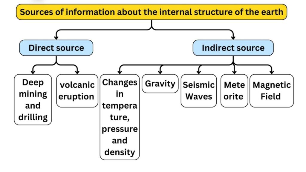
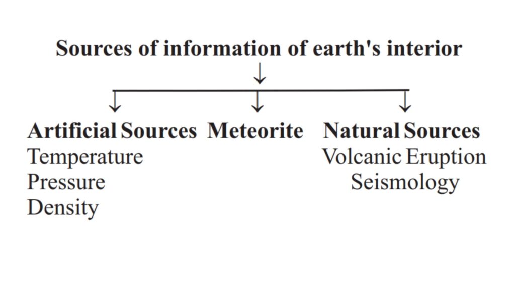
A. Direct source
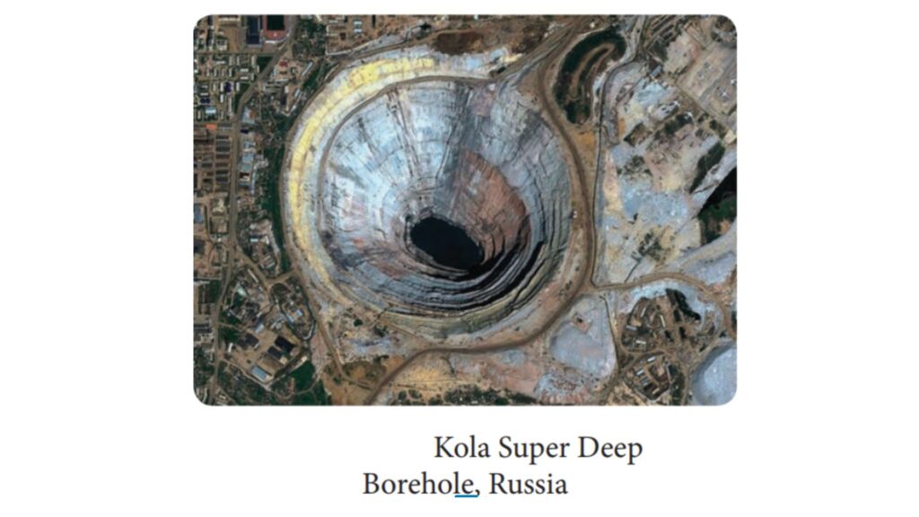
- Deep mines and drilling
- Deep mines and drilling help in studying the nature of Earth’s interior. However, extremely high temperatures limit the depth of exploration.
- Deepest Mines: Mponeng Gold Mine (South Africa) – 3.9 km deep, TauTona Gold Mine (South Africa) – Another deepest mine in the world.
- Apart from mining, deep ocean drilling projects are conducted for subsurface exploration.Major Projects: Deep Ocean Drilling Project (DODP). Integrated Ocean Drilling Program (IODP).
- The deepest drilling ever conducted was by the Soviet Union in the 1970s. Kola Superdeep Borehole in the Arctic Ocean reached a depth of 12 km. This borehole provided valuable insights into Earth’s deep crust.
- volcanic eruption
- When volcanic eruptions bring lava to the Earth’s surface, it becomes available for laboratory analysis. However, determining the exact depth from which the magma originated is difficult.
B. Indirect Source
Changes in temperature, pressure and density
Mining operations reveal that as depth increases, temperature, pressure, and density also increase. The rate of change of these factors can be estimated.
- Temperature- Geological surveys show that temperature increases by 1°C every 32 meters of depth. Due to increasing pressure, the melting point of rocks rises, preventing all materials from melting.The rate of temperature increase slows down as we move towards the Earth’s core. Based on calculations, the temperature at Earth’s core exceeds 6000°C.
- Pressure- With increasing depth, pressure also increases, leading to higher density towards the core. The extreme heat at the core keeps materials in a semi-liquid state, but intense pressure makes them behave like a solid. Therefore, the Earth’s inner core has a plastic-like consistency despite high temperatures.
- Density- As pressure increases and heavier materials accumulate toward the Earth’s core, the density of its layers also increases. According to Newton’s Law of Gravitation, the average density of the entire Earth is calculated to be 5.5 g/cm³.
Gravitation
- Gravitational force is not uniform across different latitudes on Earth.
- It is stronger at the poles and weaker at the equator due to the difference in distance from Earth’s center.
- Gravitational force also varies based on the mass distribution of materials.
- Uneven distribution of materials inside the Earth affects gravitational variation.
- Gravity Anomaly : The variation in gravity at different locations is called Gravity Anomaly.
- It provides insights into mass distribution within the Earth’s crust.
Meteorite
- Meteorites are part of the solar system.
- These (meteoroids) are solid bodies made of the same material from which the earth is made.
- Nickel and iron are found in the organizational structure of meteoroids. The earth has the property of magnetism, this property has developed in the earth due to nickel-iron mixed in the inner part.
Magnetic Field
- Magnetic surveys help understand the distribution of magnetic materials within the Earth’s crust.
- Earth’s magnetic field is explained by the Geodynamo Effect .
- Changes in the magnetic field provide information about the iron core of the Earth.
Sources based on seismic waves
- Seismic waves undergo reflection and refraction when they pass through materials of different densities.By analyzing these waves, scientists can determine the Earth’s internal structure.
- Seismic waves originate from the earthquake focus and travel in all directions within the Earth.
- All natural earthquakes occur in the lithosphere.
- These waves are mainly of three types-
- P (Primary Waves)
- S (Secondary Waves)
- L (Long or Surface Waves)
- ‘P’ waves are longitudinal waves, similar to sound waves. Fastest seismic waves and travel through solids, liquids, and gases. Their speed is higher in solid materials than in liquids or gases.
- S-Waves are transverse waves, similar to light waves. They are slower than P-waves and are experienced after P-waves. Can only travel through solid materials, meaning they disappear in liquid regions.
- Relationship Between Seismic Wave Speed and Density.Seismic wave velocity is directly related to the density of Earth’s layers. The increase in seismic wave velocity in deeper layers proves that Earth’s internal layers are denser than the surface layers. The curved paths of seismic waves confirm that Earth’s internal composition is not uniform.
- Gutenberg Discontinuity (at 2,900 km depth) P-waves slow down, and S-waves completely disappear at this boundary. This confirms that the Earth’s outer core is in a liquid state, as S-waves cannot travel through liquids.
- The solid nature of the crust and mantle is confirmed because both P and S waves travel through them.
- The structure of the interior of the Earth is revealed based on the speed and direction of these waves.
The movement and behavior of seismic waves provide crucial information about the internal structure of the Earth.
Three layers of the interior of the Earth
1. Crust
- The uppermost and thinnest layer of the Earth.
- This layer is found up to a depth of 35 KM from the surface of the Earth.
- Its thickness in continental areas – about 35 KM and in oceanic areas it is 5 to 10 KM.
- The layer is made of light rocks and the density is 3 grams per cubic cm.
- Upper Crust (0-25 km)
- Density 2.7 gm/cm³.
- This layer is mainly made up of granite rocks and forms the continents. (Continental Crust)
- Conrad discontinuity lies between the upper crust and lower crust.
- Lower Crust (25-35 km)
- Density 3 gm/cm³.
- This layer is mainly composed of basalt rocks and forms the floor of the ocean. (Oceanic crust)
- Mohorovicic discontinuity lies between the lower crust and the upper mantle.
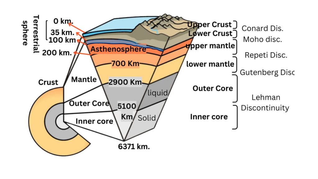
2. Mantle and substratum
- S waves disappear after 2900 km. That is, the mantle is made up of solid rocks.
- Its density is found to be up to 5.5 grams per cubic cm. [Average density 4.6 gm/cm³]
- 83 percent of the total volume of the earth and about 68 percent of the mass is present in the mantle.
- This layer is found between the depths of 35 to 2900 km. This layer is mainly made up of silica and magnesium. Hence, it is also called the boundary layer.
- This layer is mainly made up of peridotite rocks.
- Upper Mantle
- The upper mantle is located between 35 to 700 km, in which the asthenosphere is located between 100 to 200 km, which is in a semi-liquid state due to the disintegration of radioactive substances.
- The part above the asthenosphere is called the lithosphere (0 km to 100 km).
- The asthenosphere is also called the low-speed sphere because the speed of seismic waves keeps decreasing in this sphere.
- Lower Mantle
- The lower mantle is located between 700 and 2900 km.
- The Repeti discontinuity is located between the upper mantle and the lower mantle.
- The Gutenberg discontinuity is located between the lower mantle and the core.
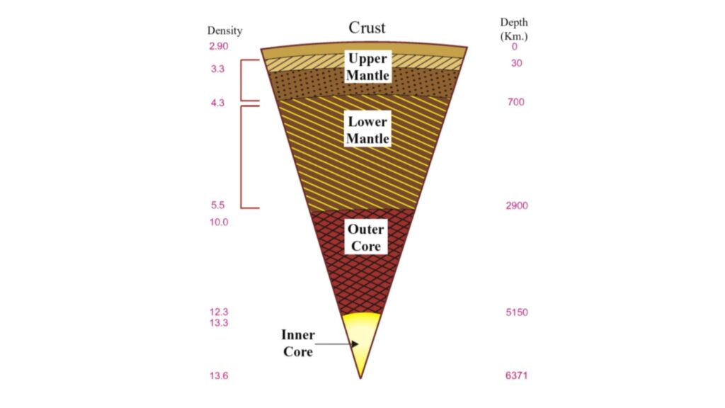
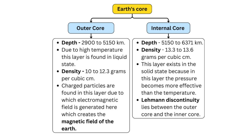
3. The core
- 2900 km. to 6371 km. This part with a depth of 2900 km. is the innermost part of the earth.
- Its density is 11 grams per cubic cm.
- S waves cannot reach this part
- 16 percent of the volume of the earth and 32 percent of its mass is present in the core.
- The core is made of heavy substances mainly nickel and iron.
- The core of the earth is divided into two parts-
Classification of Suess –
According to Suess, the upper part of the earth’s crust is made up of layered rocks. Below this part, Suess has considered the position of three layers on the basis of chemical composition –
1. SiAl
- Silica and aluminium Si+Al predominate in this layer. Hence, it is called Sial.
- Average density is 2.9 and average depth is 50 to 300 km.
2. SiMa
- Silica and magnesium are predominant in this layer, therefore this layer is called (Si+Ma= SiMa).
- The density is 2.9 to 4.7 and the depth is 1000 to 2000 km.
3. NiFe
- Nickel and ferrous are predominant in this layer. Therefore, this layer is called Nife (Ni + fe = Nife).
- The density is 11 and it extends till the center of the earth.
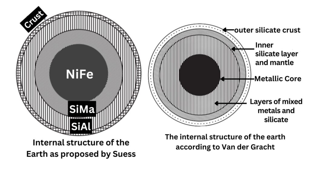
Van der Gracht’s classification
Van der Gracht has described four layers of the internal structure of the earth which are as follows-
1. Outer silicate crust
- The thickness of the layer is up to 60 km under the continents. It is up to 20 km under the Atlantic Ocean and up to 10 km under the Pacific Ocean.
- The density of the layer is 2.75 to 3.1.
- The layer is made of silica, aluminium, potassium and sodium.
2. Inner silicate layer or mantle
- Thickness of the layer is 60 to 1200 km.
- Density is 3.1 to 4.75.
- Silica, magnesium and calcium elements are found in the layer.
3. . Layers of mixed metals and silicate –
- Oxygen, silica, manganese and iron compounds and a mixture of nickel and iron are found in this layer.
- Density is 4.75 to 5.0 grams per cubic cm and thickness is up to 1800 km.
4. Core / Metallic Core
- It is made of pure nickel and iron.
- Density is 11.0 grams per cubic cm or more.
- The thickness of the layer is 3600 km.
Discontinuity
The area found between the layers of the earth where the characteristics of two layers are present together is called discontinuity. Mainly two types of discontinuities are found on the earth and some minor discontinuities are found.
The following discontinuities are found on the earth-
- Conrad Discontinuity – Transition zone located at a depth of 5 to 10 km between the upper crust and lower crust.
- Mohorovicic Discontinuity – Transition zone located at a depth of about 100 km between the lower crust and upper mantle.
- Reppeti Discontinuity – Transition zone located between the upper and lower mantle located at a depth of about 700 km.
- Gutenberg Discontinuity – Transition zone between the lower mantle and upper core located at a depth of about 2900 km.
- Lehmann Discontinuity – Transition zone located at a depth of about 5100 km between the outer and inner core.
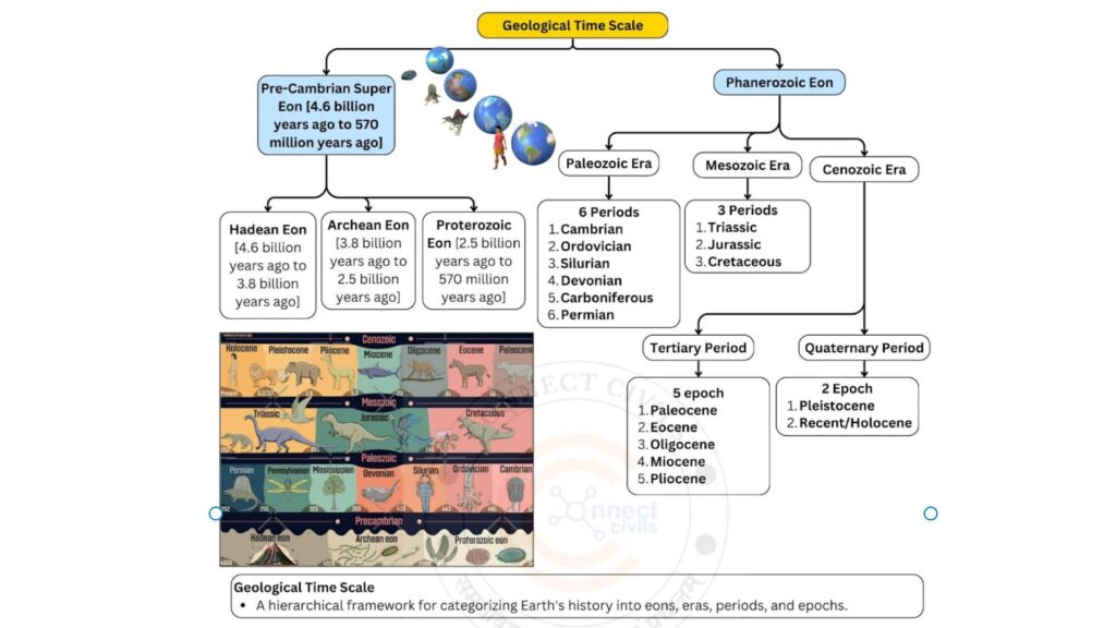
Geological time table
|
|
|
|
|
Age/Modern years ago |
Major Events |
|
Phenerozoic eonThis Eon tells the history of the earth from 570 million years ago to the present. This is also called the Visible Eon. Remains of organisms started being found in this Eon. It tells about the diversification of life and the evolution of plants and the journey from invertebrates [vertebrates] to modern humans. The earth acquired its present form in this Eon. Although this Eon is of very short duration and is only ⅛ part of the history of the earth. But still it is very important because extensive changes took place in this period. |
New life (63 million years ago) (Cenozoic era) |
|
Recent/ Holocene |
0 to 10000 |
Note : Meghalayan period The latest part of the Holocene epoch saw severe droughts on Earth and a significant drop in temperature. An era of global aridity. |
|
Pleistocene |
10,000 to 20 lakh years |
|
|||
|
|
(Tertiary) |
|
Pliocene Pliocene |
20 lakh to 50 lakh |
|
|
Pleistocene Miocene period |
50 lakh to 2.4 crore |
|
|||
|
Pleistocene Oligocene period |
2.4 crores to 3.7 crores |
|
|||
|
Early Eocene |
3.7 crores to 5.8 crores |
|
|||
|
Late Paleocene |
5.8 crores to 6.5 crores |
|
|||
|
Mesozoic era(65 million to 245 million years ago) |
Cretaceous |
6.5 crore to 14.4 crore |
|
||
|
Jurassic |
14.4 crores to 20.8 crores |
|
|||
|
Triassic |
20.8 crores to 24.5 crores |
|
|||
|
|
Permian |
24.5 crores to 28.6 crores |
|
||
|
Carboniferous |
28.6 crores to 36.0 crores |
|
|||
|
Devonian |
36.0 crores to 40.8 crores |
|
|||
|
Corallodon / Silurian |
40.8 crores to 43.8 crores |
|
|||
|
Ordovician |
Rs 43.8 crore to Rs 50.5 crore |
|
|||
|
Cambrian |
50.5 crores to 57.0 crores |
|
|||
|
(Proterezoic eon) |
Precambrian570 million years to 4 billion 800 million years ago |
|
|
570 million to 2.5 billion years |
|
|
Archaean eon |
PRE CAMBRIAN SUPER EON |
3.8 billion years ago to 2.5 billion years ago |
|
||
|
|
4.6 billion years ago to 3.8 billion years ago |
|
|||
|
origin of stars |
5 billion years to 13.7 billion years ago |
|
|
5 billion years ago |
|
|
Supernova |
12 billion years ago |
||||
|
Big bang |
13.7 billion years ago |
|
Earth’s Structure and Geological Time Table / Earth’s Structure and Geological Time Table/ Earth’s Structure and Geological Time Table/ Earth’s Structure and Geological Time Table/ Earth’s Structure and Geological Time Table / Earth’s Structure and Geological Time Table/ Earth’s Structure and Geological Time Table / Earth’s Structure and Geological Time Table
