
In Indian Geography, the natural vegetation of India, including tropical evergreen, deciduous, mangrove, and desert forests, showcases the country’s climatic and topographic diversity, as detailed in the India State of Forest Report (ISFR) 2023. These ecosystems, from the dense Western Ghats to the sparse Rajasthan deserts, support rich biodiversity and sustain livelihoods across varied landscapes.
Previous Year Question
| Year | Question | Marks |
| 2021 | Discuss the geographical characteristics of Tropical evergreen forest of India. | 5 M |
General Introduction
Natural vegetation means the vegetation that grows for a long time without any external interference and its different species adapt themselves according to the soil and climate found there.
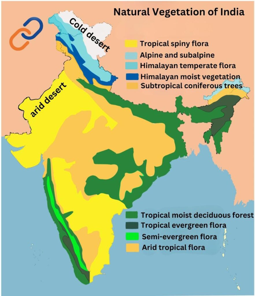
- Diversity in terms of climate in India ➟ Various types of natural vegetation are found in India
- such as – temperate vegetation in the Himalayan mountainous regions, tropical vegetation in the Western Ghats and Andaman-Nicobar Islands, tropical forests and mangroves in the delta regions and various types of shrubs, cactus and thorny vegetation are found in the desert and semi-desert regions of Rajasthan.
- Due to differences in soil and climate, regional variations are found in the vegetation of India.
- The climatic element rainfall has the greatest influence on Indian vegetation.
Other reasons for this diversity of vegetation in India are as follows:
- India’s large geographical size
- Latitudinal position
- Long coastline
- Topographical diversity
- Climatic diversity
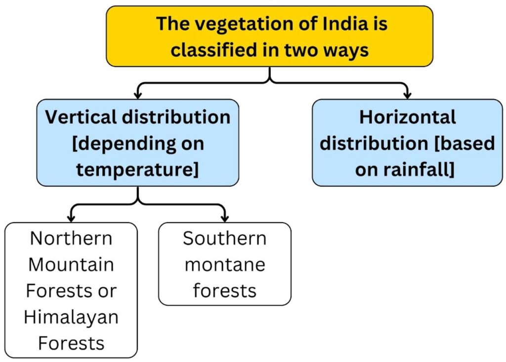
Vertical classification of natural vegetation
- After 900 meters above sea level, when we go to the mountainous region of India, the temperature affects the growth of vegetation more than the amount of rainfall.
- Due to the decrease in temperature with the increase in height, the natural vegetation has developed in the form of tropical, temperate, coniferous and tundra forests respectively.
- This vegetation can be divided into two parts-
- Northern Mountain Forests or Himalayan Forests
- Southern Mountain Forests
A. Northern Mountain Forests or Himalayan Forests
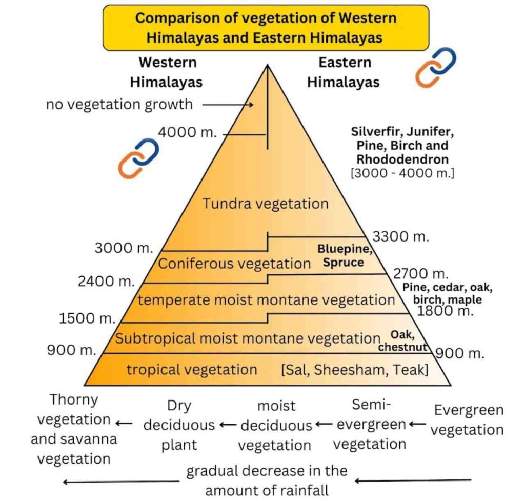
- With increasing height, vegetation ranging from tropical forests to tundra vegetation is found in the Himalayan mountain range.
- Up to a height of 900 m – Up to a height of about 900 m above sea level, the development of natural vegetation depends mainly on rainfall rather than temperature. Due to the decrease in rainfall from Eastern Himalayas to Western Himalayas, tropical vegetation developed from evergreen forests to thorny forests and savannah forests.
- Between 1,000 and 2,000 m altitude – High and dense forests of moist temperate type ➤ These are mainly found in the form of strips of forests forming a conical deep green landscape. Evergreen oak and chestnut trees are mainly found here.
- Pine forests are well developed at an altitude of 1,500 to 1,750 m ➟ Economically important. Deodar forests [wood is more strong and used in construction work] are found in the western part of the Himalayas. Chinar and Walan [wood used for Kashmir handicrafts] are found in the western Himalayan region.
- 2000 to 3000 meters- Coniferous vegetation ‘Blue Pine’ and ‘Spruce’ trees are found here. Temperate grasslands also grows at many places at this altitude.
Note – ‘Lis’ is obtained from pine tree. From which ‘turpentine oil’ is made. It is used in making soap, paint and in paper industry.
- At altitudes above 3,000 m, there is a transition between alpine forests and grassland.
- At an altitude of 3,000 to 4,000 m – there are silverfir, juniper, pine, birch and rhododendron. Seasonally migratory communities such as Gujjars, Bakarwals, Gaddis and Bhutias make extensive use of these pastures.
Features
- Compared to the Western Himalayas, the average temperature and rainfall in the ‘Eastern Himalayas’ is higher. Therefore, the density of natural vegetation, biomass and biodiversity is higher in the Eastern Himalayas.
- All types of natural vegetation spread to higher heights in the Eastern Himalayas. Example – In the Western Himalayas, coniferous and tundra vegetation is found at lower heights and in the mountainous regions above 4,000 m, tundra vegetation cannot develop due to extremely low temperatures, whereas in the mountainous regions of the Eastern Himalayas, tundra vegetation developed at an altitude of more than 4,000 m.
- Tundra vegetation such as moss, lichen, etc. are found in higher altitudes.
- More vegetation is found on the steeper southern slopes of the Himalayas as compared to the dry northern slopes.
B. Southern mountain forests
- In peninsular India, with low latitudinal geographical location, the average height is low and the average temperature is relatively high, here coniferous and tundra vegetation does not develop even in the high mountain regions.
- The southern mountain forests are mainly found in three parts of the peninsula-
- Western Ghats
- Vidhyachal region
- Nilgiri mountain range
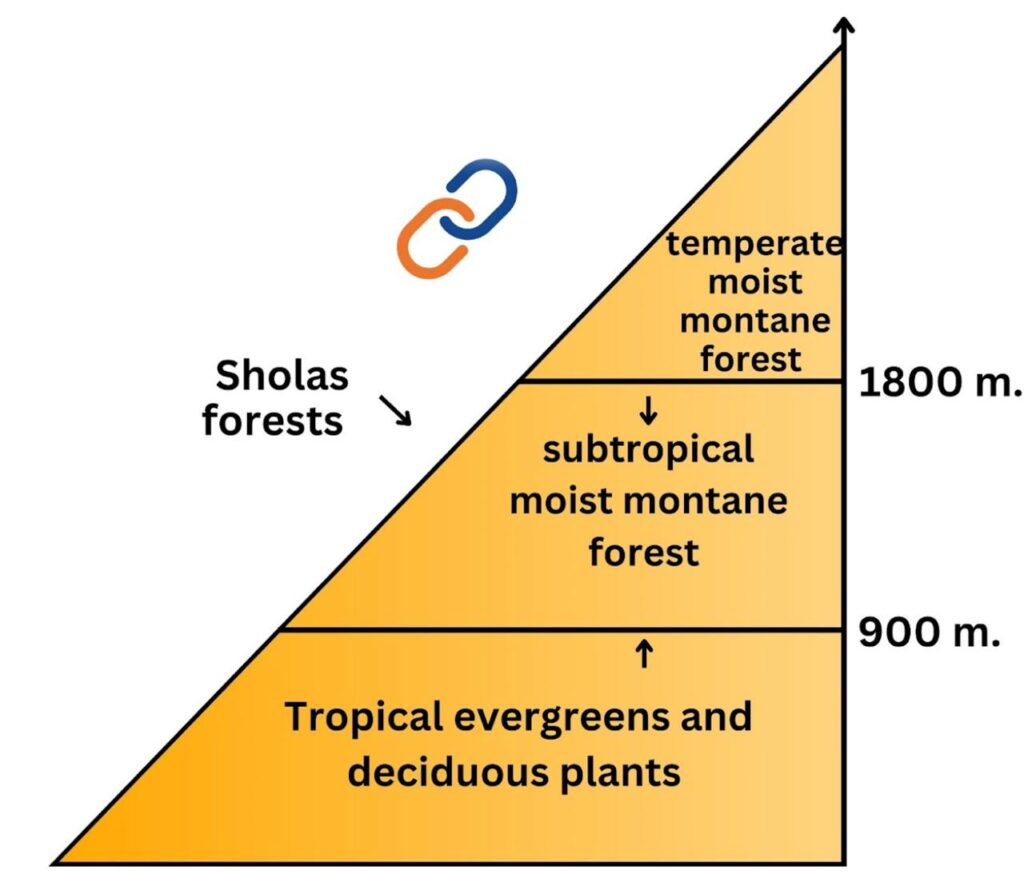
- These mountain ranges are located in the tropics and their height is approximately 1500 m above the sea level, so temperate vegetation [forests are not very dense, presence of bushes on the surface, parasitic plants, ferns, mosses, etc.] is found in the higher regions and subtropical natural vegetation [evergreen, soft wood of trees] is found in the lower regions.
- This type of vegetation is found in Kerala, Annamalai and Karnataka and Western Ghats.
- The temperate forests found in Nilgiri, Annamalai and Palani hills are called ‘Sholas’. Trees found – Magnolia, Laurel, Cinchona and Wattle, Eucalyptus and Elm are of economic importance.
- Wide open grasslands are found along with undeveloped forests or bushes.
Horizontal description of vegetation
The natural vegetation found in India is generally divided into the following types-
- Tropical evergreen and semi-evergreen forests
- Tropical moist deciduous plant
- tropical dry vegetation
- tidal vegetation and
- Mountain vegetation
A. tropical evergreen vegetation
These are tropical rain forests which are divided into the following two types based on their characteristics-
- Moist tropical evergreen –
- Found in those regions where annual rainfall is more than 250 cm, average annual temperature is more than 22°C and dry season is very short.
- Distribution – On the western slope of Western Ghats, Kerala, Karnataka, hills of north-eastern region and Andaman and Nicobar Islands.
- It resembles the equatorial vegetation. This vegetation has been destroyed due to excessive cutting.
- The number of plant species per unit area is so high that they cannot be used commercially.
- The net primary productivity of these forests is high.
- Tropical forests are dense and layered, with shrubs and vines near the ground, stunted trees above them and tall trees at the top. The height of trees in these forests can be 60 m or more.
- 5 layers of vegetation are found in forests.
- The time of leaf fall, flowering and fruiting of trees is different, hence they appear green throughout the year.
- A dense network of bushes, creepers, vines etc. is found under the trees. Grass is usually absent. The wood of the trees is very hard and heavy, hence it is not of much commercial importance.
- The main trees found are – Rosewood, Mahogany, Cinchona, Orchid, Anise and Ebony.
Note – Agumbe Forest [Karnataka] – Cherrapunji of South India, is the only natural habitat of the King Cobra. This place is also called “The Cobra Capital”. [Currently in discussion]
- Hot tropical semi-evergreen plants-
- This vegetation is limited to areas with 200 cm to 250 cm annual rainfall. These forests are a mixed form of evergreen and moist deciduous forests.
- Distribution – Western slope of Western Ghats, around Meghalaya plateau, Andaman and Nicobar Islands.
- Less dense than moist evergreen forests. The wood of the forests is of good grained quality. The height of the trees is 30 to 60 m.
- Main trees – Cider, Holak, Kail, Gurjan, Ebony, Laurel, Champa, Ironwood. [Rosewood, Aini and Telsar are the main trees of Sahyadri forests]
- These forests have been greatly depleted due to shifting agriculture and excessive exploitation.
- In recent years, rubber and oil palm trees are being planted in the area of this vegetation. Various species of orchids are seen in such forests.
- Wood is heat insulating, so it is used in building construction.
B. Tropical moist deciduous vegetation
- Found in those areas where the rainfall is between 100 to 200 cm. These trees shed their leaves in the beginning of spring and summer, hence called deciduous forest.
- Distribution – Eastern slope of Western Ghats, foothills of Shivalik, Bhabar and Terai region, North Eastern part of Peninsular Plateau, Bihar, Jharkhand, Uttar Pradesh, Odisha, West Bengal, Maharashtra, Andhra Pradesh, Karnataka, Madhya Pradesh, Chhattisgarh, Tamil Nadu and Kerala.
- The average height of trees is generally 20 to 45 m. There is a lack of bushes, creepers etc. under the trees.
- This is generally a monsoon vegetation in which varieties of trees of commercial importance are found more than in evergreen forests.
- These forests have been destroyed a lot due to indiscriminate cutting of trees for wood.
- Trees – Teak, Sal, Sandalwood, Sheesham, Cane and Bamboo, Hurra, Mahua, Amla, Semul.
C. Tropical dry deciduous vegetation
- This vegetation is found in those areas where annual rainfall is between 70 to 100 cm.
- Distribution – Mainly found in eastern Rajasthan, northern Gujarat, western Madhya Pradesh, south-western Uttar Pradesh, southern Punjab, Haryana, Maharashtra, Andhra Pradesh, Karnataka and some parts of Tamil Nadu and rain shadow region of Western Ghats.
- In these vegetation areas, the dry period is long and the trees are sparse rather than dense and extensive grasslands are found between the trees. Hence, these forest areas are better for the habitat of large animals, such as elephant, rhinoceros, lion, leopard etc.
- The trees shed their leaves during the long dry season.
- In the peninsular plateau and plains of North India with high rainfall, these forests form a ‘park-like landscape’.
- These forests have been cleared a lot for the expansion of agriculture work.
- Major trees – Mahua, Babul, Palash, Tendu, Khair, Kikar, Ber, Retha, Banyan, Peepal, Amaltas, Axlwood. The wood of ‘Khair tree’ is used to make catechu and bidi is made from the leaves of Tendu tree.
- The height of trees is usually 6 to 9 meters. Trees have long roots so that they can obtain water from depths.
- Many trees have thick bark and thick and thorny leaves to slow down evaporation.
D. Desert and semi-desert / dry tropical thorny plants
- This vegetation is found in areas with less than 50 cm / 70 cm rainfall. The following types of grasslands are found.
- These trees are in the form of small bushes. Generally, the maximum height of trees is up to 6 m. The roots of the trees are long, leaves are thick and thorny.
- Distribution – Western Rajasthan, some areas of Northern Gujarat, Madhya Pradesh and Chhattisgarh, rain shadow region of Western Ghats
- Main trees – Khejra, date palm, cactus, acacia. Palash (Butea monosperma) is also called forest fire.
Savanna Vegetation
- This vegetation is generally found in areas with annual rainfall less than 60 cm.
- Small trees and grasses are the main characteristics of this vegetation.
- These areas are less rich in terms of fertility. In India, they are commonly known as barren regions.
- These regions are present in some parts of the states of Maharashtra, Andhra Pradesh, Madhya Pradesh and Karnataka.
- These areas are also home to species like the Great Indian Bustard, Lesser Florican and the Indian Wolf.
Desert Vegetation
- These vegetation are found in those areas where annual rainfall is less than 50 cm.
- The trees of these forests are usually scattered. Many types of grasses and bushes grow in these types of forests and their roots are long and spread all around in search of water.
- The leaves of the trees found here are usually small, waxy and have thick bark, so that evaporation is minimized.
- These types of forests are found in the semi-arid areas of south-west Punjab, Haryana, Rajasthan, Gujarat, Madhya Pradesh and Uttar Pradesh.
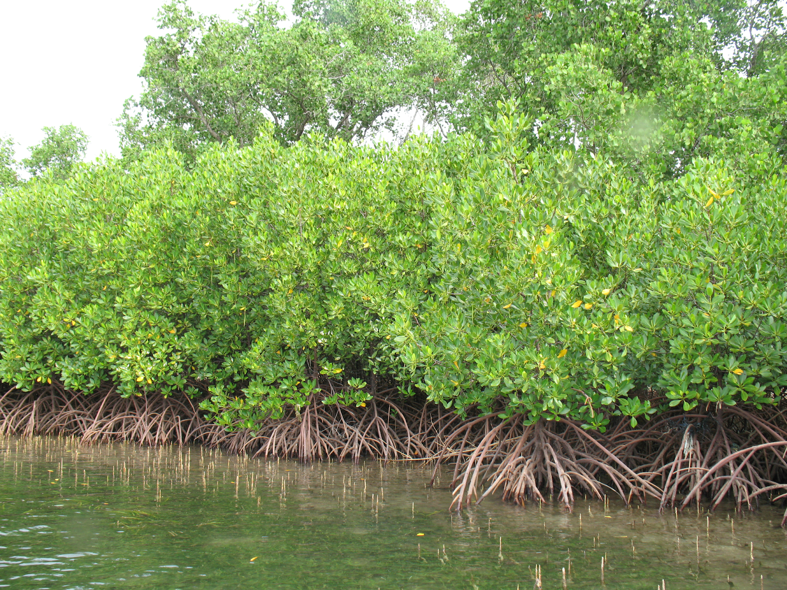
Tidal vegetation / mangroves
- Mangroves are a group of salt-tolerant plant species native to tropical and subtropical intertidal zones of the world. Mangroves grow in coastal areas of salt marshes, tidal creeks, mudflats and estuaries.
- As per ISFR 2023, the mangrove cover in India is 4,992 sq km [0.15% of the country’s area].
- Highest tidal vegetation in India – West Bengal – 42% [Sundarbans Delta] > Gujarat [23%] > Coastal areas of Andaman – Nicobar Islands, besides in the deltaic areas of Mahanadi, Godavari and Krishna rivers.
Note – Overall decrease in mangrove cover by 7.43 sq km compared to 2021 [more in Gujarat]. At the same time, increase in mangrove forest cover occurred in Andhra Pradesh (13 sq km) and Maharashtra (12 sq km).
- Not all coastal areas are suitable for the growth of tidal vegetation because for their growth and maintenance, a proper mixture of fresh and salt water and soft soil (soft surface) like muddy soil is also necessary.
- Tidal vegetation (mangrove) acts as a bridge (symbiotic contact) between marine and terrestrial ecosystems.
- This area is an area of high biodiversity. Vegetation found here – Mangrove, Sundari, Casuarina, Kevada, Sonerita, Phoenix. Due to the abundance of Sundari plants in the deltaic areas of West Bengal, the deltaic area is known as ‘Sundarban Delta’. Palm trees are predominant on the coast of Tamil Nadu and coconut trees are predominant on the coast of Kerala.
- Mangroves exhibit viviparity mode of reproduction, where the seeds germinate within the tree before falling to the ground. Mangrove plants have specialized roots called pneumatophore roots and respiratory roots, which help in obstructing the flow of water.
- Importance
- Home to a wide range of fauna including Royal Bengal Tiger, Irrawaddy Dolphin, Rhesus Macaque, Small Indian Civet, various birds.
- Dense roots prevent coastal erosion and provide protection from storm surges and tsunamis.
- Helps combat climate change by storing atmospheric CO2.
- Contributes to local livelihoods and food security by increasing fish production.
- Prevents water pollution and conserves nutrients.
- Promotes economic development through activities such as eco-tourism, birdwatching etc.
- Increasing land reclamation for agriculture and industrialization along the coast and the discharge of untreated domestic sewage and industrial wastes are damaging these forests. Upstream activities related to rivers and natural erosion and accretion also affect mangroves.
‘‘India State of Forest Report 2023’
- The India State of Forest Report is being published by the Forest Survey of India on a biennial basis since 1987.
- The Forest Survey of India makes in-depth assessment of forest and tree resources based on the interpretation of remote sensing satellite data and field-based National Forest Inventory (NFI).
- The India State of Forest Report 2023 is the 18th report in the series.
- Forest Survey of India Institute
- Established – 1 June, 1981
- Headquarters – Dehradun, Regional Headquarters (Shimla, Nagpur, Bangalore).
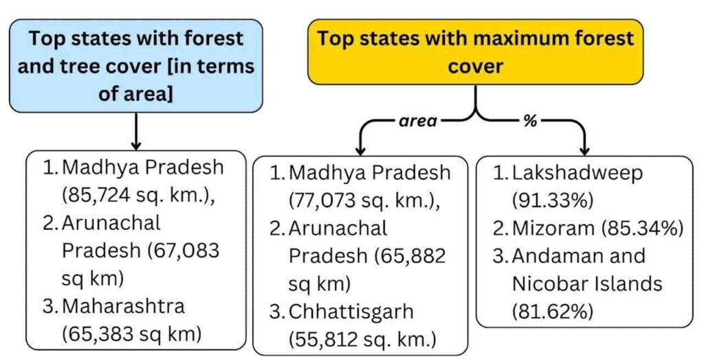
- Total Forest and Tree cover of the country – 8,27,357 sq. km [which is 25.17% of the Geographical Area (GA) of the country.]
- Area of forest cover – 7,15,343 sq. km (21.76%), while area of tree cover – 1,12,014 sq. km (3.41%).
- As compared to the year 2021, the forest and tree cover has increased by 1445 sq. km, which includes 156 sq. km increase in forest cover and 1289 sq. km increase in tree cover.
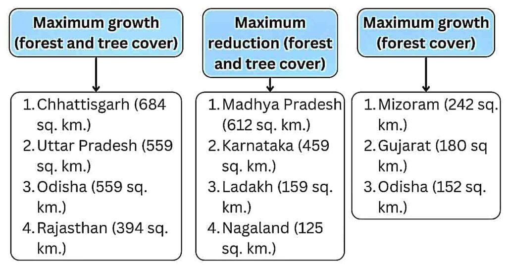
- Maximum tree cover – Maharashtra > Rajasthan (10,841 sq km) > Uttar Pradesh.
- Maximum increase in tree cover – Chhattisgarh > Rajasthan (478.26 sq km) > Uttar Pradesh (440.76 sq km).
- Higher forest cover – 19 States/UTs have more than 33% of geographical area under forest cover.
- Carbon stock – The forest carbon stock of the country is estimated at 7,285.5 million tonnes, which is 81.5 million tonnes higher than the year 2021.
- Top 3 – Arunachal Pradesh (1,021 MT) > Madhya Pradesh (608 MT) > Chhattisgarh (505 MT).
- India’s carbon stock has reached 30.43 billion tonnes of CO2 equivalent, 2.29 billion tonnes higher than the 2005 base year and close to the 2030 target of 2.5-3.0 billion tonnes.
- The Western Ghats Eco-Sensitive Region (WGESA) has 44,044 sq km (73%) of forest area.
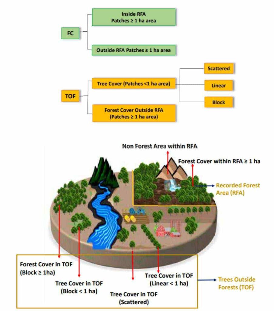
Forest cover- All land having an area of more than 1 hectare and a tree canopy density of more than 10 percent is called forest cover. The ownership and legal status of the land does not affect it; it is not necessary that such land is included in the recorded forest.
Tree cover-It includes tree patches of less than 1 hectare in size outside the recorded forest area. Tree cover includes all types of trees, including scattered trees.
Source – https://fsi.nic.in/forest-report-2023
Classification of forests according to Indian Forest Status Report
| very dense forest (VDF) | Tree canopy density 70% or more | ||
| moderately dense forest (MDF) | Canopy density 40 – 70% | ||
| Open forests (OF) | Tree canopy density 10 – 40% | ||
| Shrubs | Canopy density less than 10%, trees usually found interspersed with shrubs. | ||
Classification of forests according to Forest Department of the GoI
The Forest Department of the Government of India takes care of the forests. From the viewpoint of management, control and security, Indian forests have been divided into three parts-
|
Reserved Forests |
|
|
Protected forest |
|
|
Unclassified forest |
|
New Classification of forests according to administrative basis
In place of the above classification, now the following classification has been accepted on administrative basis-
1. State forest
- These forests constitute 95 percent of the total forest area.
- The control, maintenance, development and protection of these forests is completely in the hands of the government.
2. Community Forests-
- The total area of these forests is 3 percent of the forest area.
- The control, management and protection of forests is on the local bodies.
3. personal forest-
- This includes forests under private property.
- This is 2 percent of the total forest area.
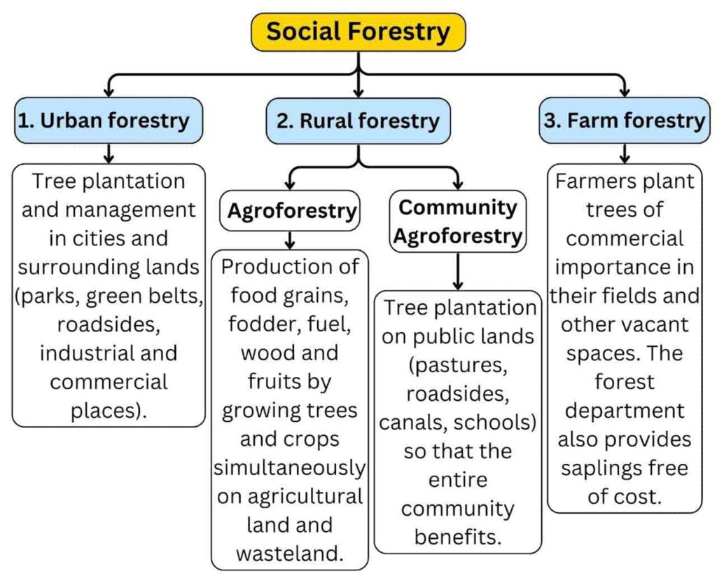
Social Forestry
- It means management and protection of forests and plantation of trees on wastelands with the objective of helping in environmental, social and rural development.
- This programme was started in 1973.
- The National Commission on Agriculture (1976-79) has divided social forestry into three categories-
National Forest Policy- 1988
- In India, the British government first declared a forest policy in 1894.
- The Government of India implemented the forest conservation policy for the whole country in 1952, which was revised in 1988.
- According to the policy, forests should cover 33 percent of the total geographical area of the country.
- 60% of the mountainous region
- 20% of the plain region
- Average – 33%
other provisions-
- Maintaining environmental balance and planting forests in ecologically unbalanced areas.
- Preservation of the country’s natural heritage, biodiversity and genetic pool.
- Preventing soil erosion ,desertification, flood and drought control.
- Expansion of forest cover through social forestry and afforestation on degraded lands.
- Providing timber, fuel, fodder and food to forest-dependent rural tribes by increasing the productivity of forests and using other materials in place of wood.
- To promote tree planting and to launch a mass movement to stop cutting of trees, in which women should also be involved, so that pressure on forests is reduced.
Benefits/Uses of Forests |
|
Direct Benefits |
Indirect Benefits |
|
|
Reasons for backwardness of forestry business:
- In India, per capita forest area is only 0.2 hectares and the distribution of forest area is uneven.
- There is a lack of modern technology and machinery for cutting.
- The economic importance of forests is low due to the absence of similar trees at one place.
- The forests are located at high altitudes and lack of transportation facilities make felling difficult.
- Lack of coordination and scientific research in forest conservation departments.
- Irregular and excessive cutting leads to soil erosion, desertification, decline in ground water level and uncertainty of rainfall.
- Less focus on economic utility of forests and sustainable development.
Forest destruction
Reason of forest destruction
- Population growth and agricultural expansion: Increasing population in 1981, 2001, and 2011 increased the demand for more food production, which led to indiscriminate deforestation for agricultural expansion.
- Industrialization and urbanization: Rapid industrialization and urbanization after independence led to large-scale deforestation for construction of industrial buildings, residential colonies, commercial centers, roads and recreational areas.
- Deforestation for domestic needs: There was rapid deforestation for construction of railways, highways, shipbuilding, furniture, building construction and fuel.
- Uncontrolled grazing: Due to lack of natural green fodder, animals eat the lower branches and cut the higher branches; the hooves of animals crush the new plants, leading to gradual reduction in forest area.
- Shifting agriculture system: Shifting of location every 3-4 years like Jhuming by Naga tribe and Dahdia agriculture by Bhils leads to rapid deforestation.
- Other causes: Development of multipurpose irrigation projects, disregard of government rules, growth in urban population, misuse of power, increasing mining, pests and diseases in trees, and conditions like forest fires also contribute to forest destruction.
Measures to improve forests:
- Strict ban on illegal and indiscriminate cutting.
- Determination of minimum forest land and effective arrangement of protected forests.
- Development of transport facilities in forest areas.
- Encouragement to forest industry, increase in employment and income.
- Acceleration in research work and public awareness programmes.
- Harmony between government departments and non-government organisations.
- Emphasis on tree plantation, advanced cutting techniques, forest fire control and cyclical cutting.
Sustainable Forest Management
- Sustainable forest management means managing forests in such a way that meets the needs of present and future generations while maintaining their biodiversity, productivity and ecological balance.
- It aims to conserve natural resources, expand forest area, tackle climate change and ensure livelihoods of communities.
Need for Sustainable Management of Forests:
- Biodiversity conservation: Protecting ecological balance and endangered species.
- Climate change: Forests act as carbon sinks, mitigating climate impacts.
- Community development: Supporting livelihoods of forest-dependent communities and tribals.
- Forest fire management: 62% of India is forest fire-prone; need to control it.
- Traditional knowledge: Conservation of medicinal plants and traditional knowledge.
Seven Components of SFM
- Expansion of forest resources
- Conservation of biological diversity
- Forest richness and vitality
- Productive functions of forest resources
- Conservative functions of forest resources
- Socio-economic functions
- Legal, policy and institutional framework
Natural Vegetation / Natural Vegetation / Natural Vegetation / Natural Vegetation / Natural Vegetation / Natural Vegetation / Natural Vegetation / Natural Vegetation / Natural Vegetation / Natural Vegetation / Natural Vegetation / Natural Vegetation / Natural Vegetation / Natural Vegetation / Natural Vegetation Natural Vegetation /
