Whenever there is mention of ancient rivers of India, three rivers emerge in Hindu ethos, viz., Ganga, Yamuna and Sarasvati. In Vedic geography, there is a mention of Sapta Sindhu, i.e., seven rivers in which Sarasvati attains an important description. Most of these rivers exist even today except Sarasvati which has disappeared completely. Information on Prehistoric India comes from two distinct sources:
- The literary tradition represented in the main by the faithfully preserved corpus of Vedic texts headed by the Rigveda.
- The archaeological tradition ranging from the Aceramic Neolithic of Mehrgarh and the various phases of the Harappan civilization to the Iron Age Painted Grey Ware and the Northern Black Polished Ware cultures.
In recent times, a third-dimension or third perspective has been added in form of Scientific Research through use of modern Technology. This article looks at these two rivers from these three different perspectives.
Sarasvati and Drishadvati: In Ancient Indian Texts
Sarasvati River:
Ambitame, naditame, devitame, Sarasvati
Aprasasta iva smasi prasastim Amba naskriti. — (Rigveda – 2. 41. 16)
(O Sarasvati, you the best of mothers, the best of rivers, the best of gods ! Although we are of no repute, mother, grant us distinction.)
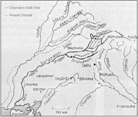
- During the vedic civilization, Aryans developed Rigveda, which describes about the ” Sapta Sindhu ” the seven rivers of NW India , traced from east to west as Sarasvati, Satadru ( Sutlej ), Vipasa (Beas), Parosni (Ravi) , Asikni (Chenab) Vitasta (Jhelum) and Sindhu (Indus) which started flowing consequent on the melting of the Himalayan glaciers at the end of Pleistocene.
- According to the Mahabharata, the Sarasvati dried up in a desert (at a place named Vinasana or Adarsana).
- In the Skanda Purana, the Sarasvati originates from the water pot of Brahma and flows from Plaksa on the Himalayas. It then turns west at Kedara and also flows underground. Five distributaries of the Sarasvati are mentioned.
- In the Manu Smriti, the sage Manu, escaping from a flood, founded the Vedic culture between the Sarasvati and Drishadvati rivers. The Sarasvati River was thus the western boundary of Brahmavarta.
Drishadvati River:
The Drishadvati river is hypothesized by Indologists to identify the route of vedic river, Saraswati, and the state of Brahmavarta. Brahmavarta is postulated as a state during vedic times, situated on the confluence of the revered rivers Saraswati and Drishadwati. Different literary sources that mention Drishadvati include:
- Latyayana Srautasutra has described drishadvati as a seasonal river, while Saraswati as a perennial river up to Vinasana.
- Brahmanas often mention the Drishadwati River. Brahmanas point out that Drishadwati River had its origin from the pot of Brahma i.e. Pushkar lake, near Ajmer. Pushkar has the most revered Brahma temple in India.
- In the Manu Smriti, Drishadvati river and the Sarasvati River define the boundaries of the Vedic state of Brahmavarta.
- According to Srimad Bhagavatam, the Drsadvati is one of the many transcendental rivers in India.
Sarasvati and Drishadvati: The Archaeological Findings
Sarasvati River:
- More than 1200 ancient settlements on Sarasvati river basin have been dug out giving clinching evidence of existence of a mighty river, which sustained maritime civilization and metal-based economy prior to 3000 BC.
- Archaeological Survey of India has dug out more than 2400 settlements at the ancient Indus-Sarasvati river basins but no ancient settlements have been found along the present day course of Yamuna or Sutlej.
- Land was fertile and barley etc were cultivated in the Sarasvati region even 7000 years back and same style of cultivating the fields continues till date in areas like Rajasthan & Haryana
Drishadvati:
- The first serious attempt on Drishadvati river was made by Sir Alexander Cunningham (1871) who identified the Drishadvati with the present Rakhsi river while Rapson (1914) felt that the Drishadvati used to flow through the present course of Chautang river which originates in Siwaliks. Subsquently, Keith (1922) and Dey (1927) also supported the course of the Drishadvati as being the present Chautang river and then along the Hansi —Hissar branch of the western Yamuna canal.
Sarasvati and Drishadvati: Scientific Research
Remote sensing data from satellites and aerial cameras has been used by several organization (including Ground Water Department, Rajasthan) to map the palaeo-channels.
Benefits of such Research:
- The search has been significant for locating sources of good quality ground water in the water scarce western Rajasthan where most of the available sources suffer from poor water quality.
Methodology of Research:
- Mapping of palaeochannels using multi sensor remote sensing data from WIFS, MSS-I, LISS-III and PAN sensors from Indian remote Sensing Satellites IRS 1B and ID was carried out using digital image processing techniques.
- Drilling work at fourteen locations in Dharmikhu – Kuriaberi – Ghantiyali – Ranau Longewala – Ghotaru sections, and the radiocarbon age analysis of the water samples thus obtained.
Research Findings:
- Digital merging of high resolution PAN and medium resolution LISS Ill data and analysis of water samples on water quality, sediment type and age of groundwater confirmed presence of palaeochannels.
- Additionally it also confirmed occurrence of good quality drinking water along these palaeochannels. The salinity of water away from the palaeochannels rises sharply.
Ancient Sarasvati and present Ghaggar-Hakra System: Relation

Since the late 19th-century, scholars have postulated that the Ghaggar-Hakra River system is the remnant of Vedic Saraswati river. The main arguments are the:
- Supposed position east of the Indus, which corresponds with the Ghaggar-Hakra riverbed.
- Painted Grey Ware sites (ca. 1000 BCE) have been found in the bed and not on the banks of the Ghaggar-Hakra river, suggesting that the river had dried up before this period.
- The Indus Valley Civilisation (Harrapan Civilisation), which is named after the Indus, was largely located on the banks of and in the proximity of the Ghaggar-Hakra fluvial system
In 2016, K. S Valdiya committee constituted by Government of India on Palaeochannels of North-West India: Review and Assessment, concluded that Saraswati river had two branches eastern & western. The eastern branch included Sarsuti-Markanda rivulets in Haryana and the western branches included Ghaggar-Patiali channels. The committee considers that branches met near Patiala, at Shatrana, then flowed as a large river.
Contradictions:
However, in recent times, these views have been contradicted by geophysical research, which suggests that the Ghaggar-Hakra system, although having greater discharge in Harappan times which was enough to sustain human habitation, was not watered by a Himalayan river—such as the Sarasvati—but rather by a system of perennial, but only monsoon fed, rivers.
Other research using dating of zircon sand grains has shown that late Pleistocene subsurface river channels near the present-day Indus Valley Civilisation sites in the Cholistan desert, in Pakistan, immediately below the dry Ghaggar-Hakra bed show sediment affinity with not with the Ghagger-Hakra river, but with the Beas river in the western sites and the Sutlej and Yamuna rivers in the eastern ones.
Sarasvati and Drishadvati: In recent NEWS
- 2019: Scientists find evidence of Saraswati’s existence (Read Here)
- Saraswati River did exist, says K.S. Valdiya Committee (Read here)
Further Reading:
- Palaeo-drainage (Download PDF)
- Serveveda
- Satellite Imagery report (Sarasvati Report)
- Vedic River Saraswati (Slideshare PPT)
- Rigvedic Saraswati: Myth or Reality (Download PDF)