In Indian Geography, population density in India, varying from high concentrations in the Gangetic plains to sparse settlements in Himalayan and desert regions, reflects diverse environmental and economic factors. States like Bihar and Uttar Pradesh exhibit high density, while areas like Ladakh remain sparsely populated.
Population Density of India
- The average number of people living per square kilometer.
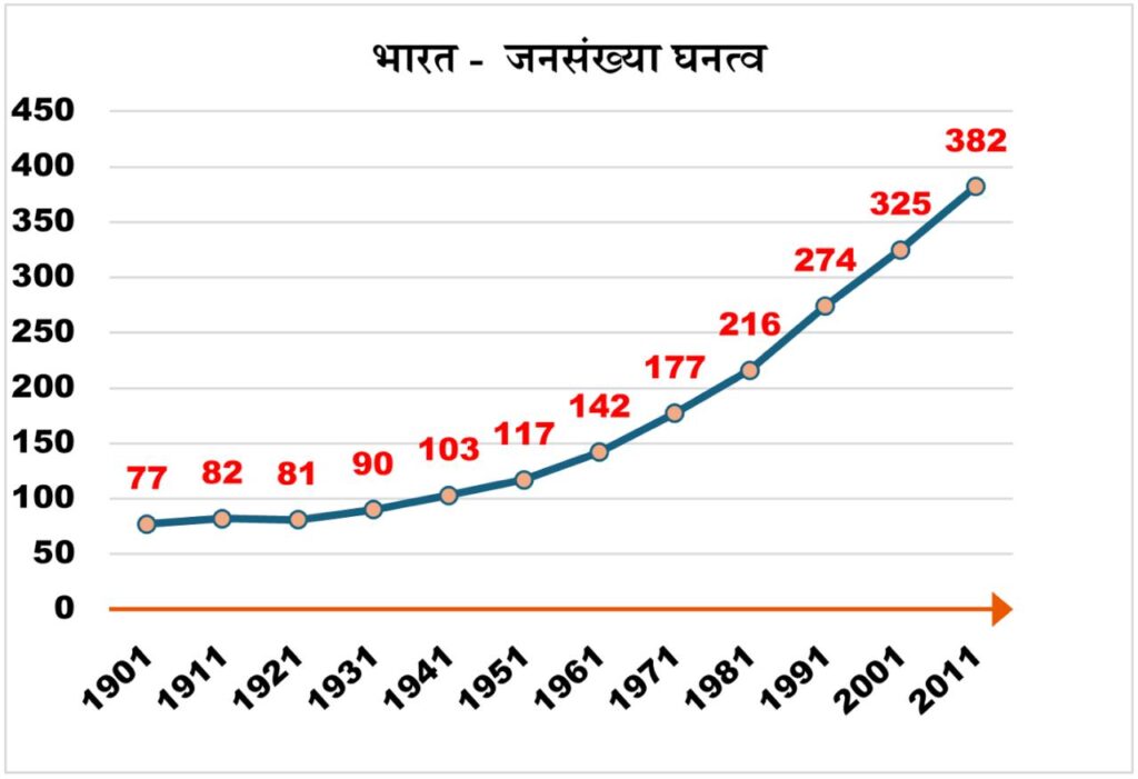
- According to Census 2011, the average population density of India is 382 persons per square kilometer. This is 57 more than the population density of 325 in 2001, which means that the pressure on land and resources has increased.
On the basis of population density, Indian states can be divided into two major categories.
- Areas with above average population density are Punjab, Haryana, Chandigarh, Delhi, Uttar Pradesh, Bihar, Jharkhand, West Bengal, Assam, Daman Diu, Dadra Nagar Haveli, Goa, Kerala, Tamil Nadu, Puducherry, Lakshadweep.
- Areas with below average population density are Jammu and Kashmir, Himachal Pradesh, Uttarakhand, Sikkim, Arunachal Pradesh, Nagaland, Manipur, Mizoram, Tripura, Meghalaya, Rajasthan, Madhya Pradesh, Chhattisgarh, Orissa, Gujarat, Maharashtra, Karnataka, Andhra Pradesh, Andaman and Nicobar Islands.
| Population Density in India – Region Wise | ||
| Category | Expansion | reason |
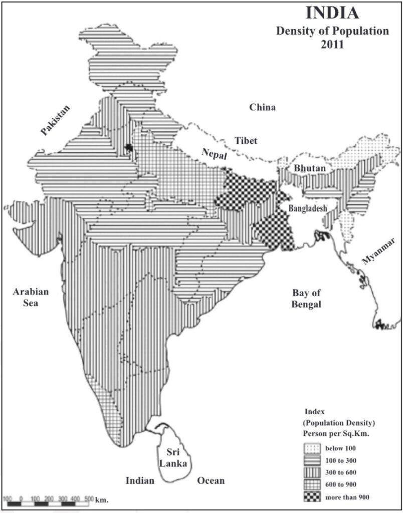
| High density areas [more than 500] | West Bengal, Bihar, Uttar Pradesh, Haryana, Kerala, Tamil Nadu. | Agriculturally dominated, rural-dominated region of the country. Flat fertile plains, alluvial soils, availability of irrigation and drinking water.Dense population due to development of plantation agriculture in the higher regions of Tamil Nadu and intensive agriculture along with small home industries in the Cauvery delta. |
| Medium density areas[300-500] | The areas with high density in northern India include Maharashtra, most parts of Gujarat, Telangana, coastal areas of Andhra Pradesh and Chota Nagpur Plateau. | Situated as a transition zone between high and low density areas.Due to unevenness of the surface and lack of water, agriculture could not develop much here. |
| Low Density Areas[less than 300] | Plateau and tribal areas of Madhya Pradesh, Chhattisgarh and Orissa, eastern part of Karnataka and central part of Andhra | Low population density due to mountainous terrain in the north-eastern Himalayas and low population density due to desert in western Rajasthan |
On the basis of population density, states can also be divided into the following categories –
| Category | Population Density [people/sq km] | State / UTs |
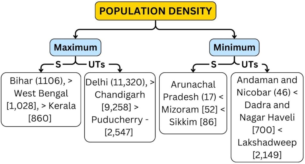
| Highest population density | More than 900 | Delhi, Chandigarh, Puducherry, Daman and Diu, Lakshadweep, Bihar, West Bengal |
| High population density | 600 to 900 | Kerala, Uttar Pradesh, Dadra Nagar Haveli |
| Moderate population density | 300 to 600 | Punjab, Haryana, Assam, Tripura, Jharkhand, Gujarat, Maharashtra, Andhra Pradesh, Karnataka, Goa, Tamil Nadu. |
| Low population density | 100 to 300 | Jammu and Kashmir, Himachal Pradesh, Uttarakhand, Meghalaya, Nagaland, Manipur, Rajasthan, Madhya Pradesh, Chhattisgarh, Odisha |
| Minimum population density | less than 100 | Sikkim, Arunachal Pradesh, Mizoram, Andaman and Nicobar Islands. |
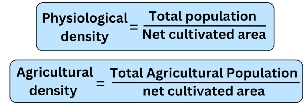
The largest part of India’s population (more than 50%) is currently engaged in agriculture and related activities. Therefore, measuring the density of agricultural population (farmers, agricultural labourers and their family members) and total population in relation to agricultural land –