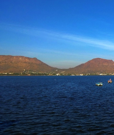
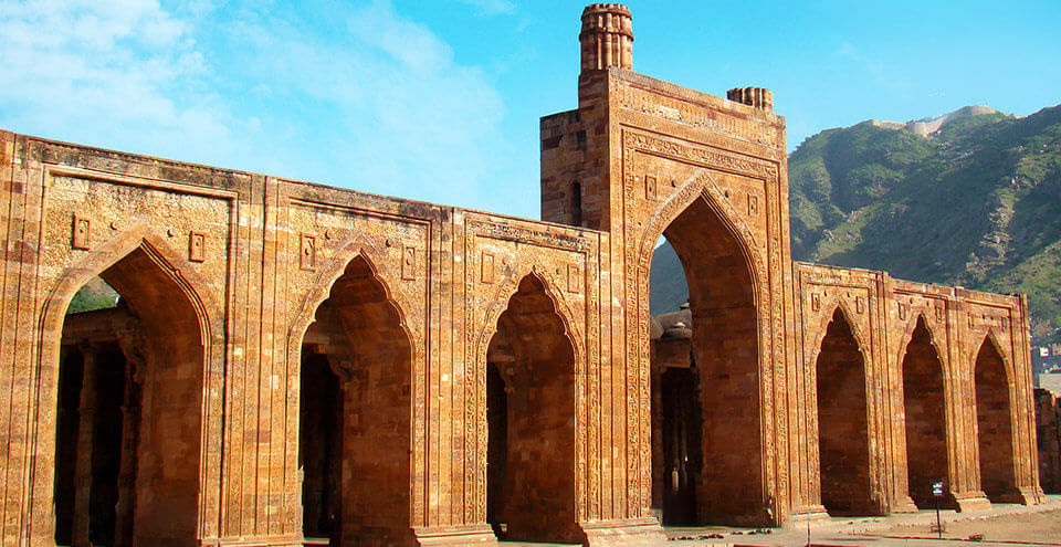
A perfect representation of the diversity of the Indian culture, the city of Ajmer is a revered pilgrimage centre for both Hindus and Muslims. Dargah Sharif, Pushkar, Soni ji ki Nasiyan display a perfect blend of different religion, community & cultures, coexisting and flourishing in harmony. It is a pilgrimage centre for the shrine of the Sufi Saint Khwaja Moinuddin Chishti and Brahma Temple in Pushkar. Ajmer has been selected as one of the heritage cities for Heritage City Development and Augmentation Yojana Scheme (Hriday) of Government of India.

History of Ajmer
The history of Ajmer sublimes in 7 century A.D, when scion from Macavati of Chauhan dynasty, Ajaipal established himself at Ajmer and erected the fort of Tarragarh(present name). His successor Dola Rae, lost Ajmer to Islamic Invasions, to be recovered by Manik Rae.
Rao Beelundeo defended Ajmer against Mahmud of Ghazni and Ajmer continued to be ruled by Chauhan dynasty, in spite of repeated invasions by Turkic Muslim armies from Central Asia across the north of India. Prithviraj Chauhan, also known as Rai Pithora succeeded to the throne in 1178 CE at the age of 13. Chauhan defeated Muhammad Ghori in the First Battle of Tarain in 1191 but was defeated, captured at the Second Battle of Tarain (1192).
Khawaja Muinuddin Chishti famous as Garib Nawaz, visited Ajmer during reign of Prthvi Raj Chauhan and established the Chishti Order of Sufism in the Indian subcontinent.
Even after the state was conquered by Muhammad of Ghor, founder of the Delhi Sultanate. The Chauhan rulers were able to gain autonomy upon the payment of a heavy tribute to him. Ajmer regained independence under the ruler of Mewar in 1365. Shortly there began contest between Maharajas of Mewar and Marwar for control of the region, until 1532 when it was conquered by the Marwar.
In 1553, the state was controlled by the Hindu Emperor Hem Chandra Vikramaditya (Hemu). In 1556, Hemu was defeated and killed in the Second Battle of Panipat and control of state passed to the Mughal emperor Akbar in 1559.
It was in Ajmer that Sir Thomas Roe, as ambassador of King James I of England, had his audience with Emperor Jahangir on 19th January 1616 A.D. which laid the stepping stone of the British Raj in India through the charter of free trading granted to the East India Company by the Emperor.
In 1627 A.D, it was in Ajmer that Shah Jahan, on the death of Jahangir, proclaimed himself Emperor of India while returning from Udaipur and proceeding to Delhi. And after a furious battle on 11th, 12th and 13th of March 1659 A.D, it was in Ajmer again that a beginning of the decline of Moghul Empire was made with the victory of Aurangzeb against his brother Dara Shikoh .
In the early 1700s century, control passed to the Marathas.
In 1818, the state became part of the Province of Ajmer-Marwar in the colonial British Raj when British forced the Marathas to cede the city for 50,000 rupees. It consisted of the districts of Ajmer and Merwara region, and were physically separated by the territory of the Rajputana Agency. Ajmer-Marwar was directly administered by the British Raj, by a commissioner who was subordinate to the Governor-General’s agent for Rajputana.
Ajmer-Marwar remained a province of India until 1950, when it became the Ajmer State. This state became part of Rajasthan state on 1 November 1956

Location, Area & Administration
Ajmer is located at an altitude of 200 meters from sea-level with co-ordinates 26° 27, N. lat. and 74° 44, E. long. Situated on slopes of Taragarh hills, Ajmer occupies the heart of Rajasthan.
Ajmer is surrounded by Tonk & Jaipur districts in east, Nagaur in north, Pali district to the west and Rajsamand & Bhilwara district to the South.
The Ajmer district is presently consist of twelve sub-division viz; Ajmer, Beawar, Nasirabad, Masuda, Kekri, Kishangarh, Sarwar, Bhinai, Pushkar, Roopangarh and Tatgarh with a view to have better control and smooth working.
The sub-divisions have further divided into 16 Tehsils namely Ajmer, Beawar, Nasirabad, Kekri, Kishangarh, Masuda, Bhinai, Pisangan, Sarwar Pushkar, Roopangarh, Arain, Tatgarh, Bijainagar and Tantoti and nine Panchayat Samitties namely Shrinagar, Pisagan, Jawaja, Masuda, Bhinai, Kekri, Silora, Sarwar and Arain.

Geography of Ajmer
The eastern portion of the district is generally flat, broken only by gentle undulations. The western parts, from north-west to south-west, are intersected by the Aravalli Range. Many of the valleys in this region are sandy deserts, part of India’s Thar Desert, with an occasional oasis of cultivation. Some fertile tracts are also present; among these is the plain on which lies the town of Ajmer. This valley has an artificial lake, and is protected by the massive walls of the Nagpathar range or Serpent rock, which forms a barrier against the sand. The only hills in the district are the Aravalli Range and its offshoots.
Five rivers viz. Banas, Khari, Poonagar, Sagarmati and Sarswati flow through the district, but all these rivers being non-perennial remain dry except during the monsoon season, thus the water in the district is made available for most of months through wells.
Banas River that touches south-eastern boundary of the district near Samur. Khari river forms the boundary between Ajmer and Bhilwara districts. Luni river has its origin in the valley of Nag Pahar and two small streams—the Sagarmati, Saraswati, pour their waters into Luni.
Water received from Sagarmati and Saraswati rivers is fresh and potable and it is used for drinking purpose in the city. At present water supply is being made from Bisalpur Project to Ajmer, Beawar. After Bisalpur supply drinking water scarcity is almost no more and un-interrupted water supply is ensured.
Natural Resources:
Ajmer district is the prime producer of quartz and leading producer of feldspar. Other mineals available in the district are basemetals, cement grade limestone, granite, marble, asbestos, wollastonite, garnet, calcite, emerald, soapstone, magnesite, fluorspar, mica etc.
Climate & Rainfall
Ajmer district has a hot and dry summer and a cold bracing winter. The cold season generally remains from December to February and thereafter the hot season commences and continues upto last week of June being the hottest part of the year.
Population:
According to the 2011 census, Ajmer has a population of around 551,360 in its urban agglomeration and 542,580 in the city. In average literacy, Ajmer occupies 8 position among districts of Rajasthan. It has male literacy rate is at 82.4 percent and female literacy rate of 55.7 percent to have combined rate of 69.3 percent.

Places to See
Recent News on Ajmer:
- Kumbhalgarh TR: Survey for Tiger Reserve Status in September 2021

- Unnat Bharat Abhiyan (UBA) to start in 11 districts

- September 2020: Rajasthan Current Affairs Summary

- Nasha Mukt Bharat Action Plan Launched

- Places to See in Ajmer

- History of Ajmer

Location Map
Ajmer is located at an altitude of 200 meters from sea-level with co-ordinates 26° 27, N. lat. and 74° 44, E. long. The district is surrounded by Tonk & Jaipur districts in east, Nagaur in north, Pali district to the west and Rajsamand & Bhilwara district to the South.
How to Reach Ajmer
By Air
The nearest airport is Kishangarh Airport, located on NH-8 about 27 km North-East of the city. One can easily pre-book a cab or hire one from the taxi stands outside the airport. The journey will take around 39 mins. Additionally, Sanganer airport of Jaipur is also an option, Sanganer airport is about 135 Kms from city.
By Train
By Bus
Buses from the state capital and from other cities also ply to the city regularly. Government buses run between Jaipur and the city throughout the day. Private operators also ply on the route.
Road/ Self-Drive
A dense network of bus service operates from Ajmer to key destinations around. Distances from important tourist centres are: –
Jaipur: 138 kms | Delhi: 392 kms | Ahmedabad: 526 kms | Jaisalmer: 490 kms | Bikaner: 233 kms |
