Location, Area & Administration:
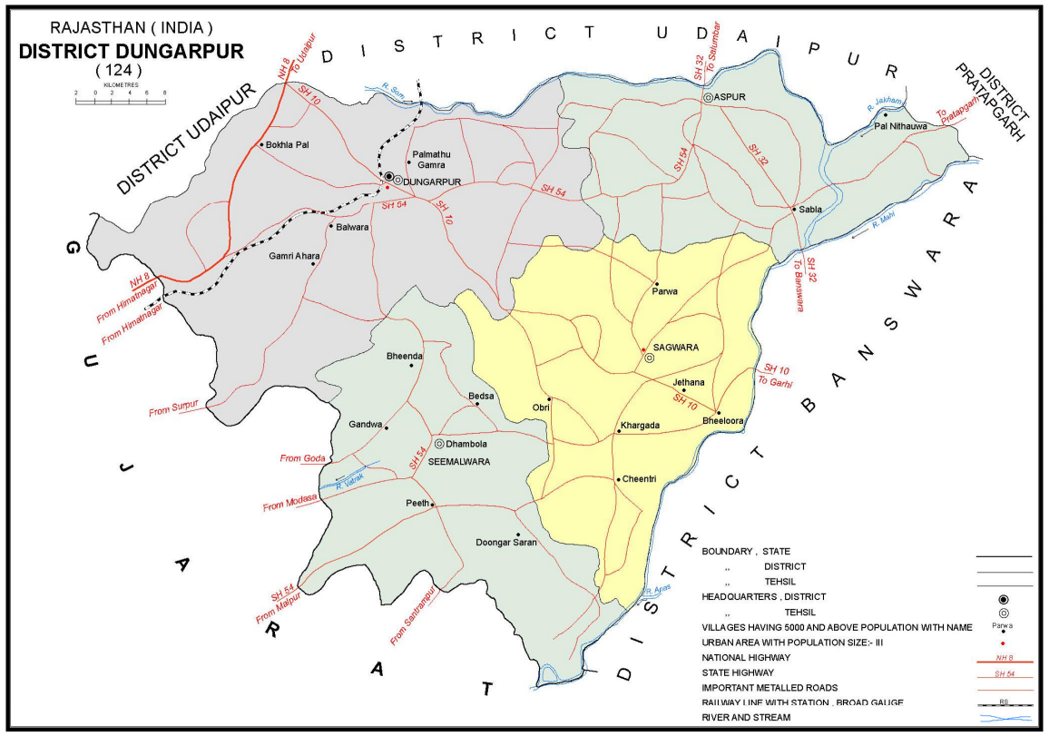
Dungarpur district is the third smallest district in Rajasthan, situated in the Southern part. It lies between 23.20′ and 24.01 N latitude and 73*.22′ and 74.23′ E longitude. . It is bounded on the north by Udaipur district and on the east by Banswara district. On its South and west, it has common border with state of Gujrat.
Dungarpur has an area of 3781 sq. Km’s which is divided into 5 tehsils Aspur, Dungarpur, Sagwara, Simalwara and in 2007, new tehsil of Bichiwara (Bichhiwara) was created out of the western part of Dungarpur Tehsil.

Dungarpur History
The material remains of the Ahar civilization discovered in Mewar region constitute remnants of the civilization which may date back to 4000 year ago. From Ahar this culture extended to other centers in the south-east of Rajasthan including parts of present Dungarpur and Banswara district. As a proof, silver coins belonging to 181-353 AD have been unearthed in thousands from Sarwaniya village in Banswara district, also a part of ‘ Bagar’. The coins establish that this territory was, then, ruled by Kshtrapas or Satraps of the Saka, inhabitants of area lying between Iran and Afghanistan. They entered Afghanistan and India sometime in the first century of the Vikram Era.
However the Gupta rule over this tract cannot be ascertained with exactitude. Thereafter, the territory may have formed a part of the kingdom of Vallabi. Bagar is said to have been invaded by the Arabs between 725 A.D. and 738 A.D. However, their attacks were repelled and they were expelled from these parts.
From the time the parmars of Malwa came to rule Bagar, we get a clear and continuous history of this area. In 1197, Samant Singh, the eldest son of the ruler of Mewar, Karan Singh, the Guhils of Mewar (Udaipur) established their suzerainty in this area.
It is mentioned in the ‘Khyats’ that Maharawal Veer Singh Dev, the Sixth descendant of Sawant Singh of Mewar, assassinated powerful Bhil Chieftain Dungaria and took possession of Dungaria’s village and founded that town of Dungarpur in 1258 A.D.
Rulers of Dungarpur:
- Rawal Veer Singh
- Founded State of Dungarpur
- Killed in the sack of Chittor by Allauddin Khilji.
- Bhachundi
- Erected the Hanumat Pol
- Rawal Gopinath
- Victory over Ahmedshah, the Sultan of Gujarat in 1433 A.D.
- Built the Gaipsagar lake at Dungarpur
- Rawal Somdasji
- Repelled the invasion of Sultan Mahmood Shah and Gayasuddin
- Maharawal Udai Singh I
- Divided ‘Vagad’ into two parts. The western portion, with the capital at Dungarpur, he retained for his elder son Prithviraj and the eastern portion subsequently known as Banswara, gave to his younger son Jagmal.
- Maharawal Askaran
- Acknowledged the Mughal suzerainty and became a vassal of the Empire
- Maharawal Punjaraj
- Emperor Shahjahan, conferred on him the insignia of the ‘Mahimaratib’ and a grant of a Dedhahazari Mansab’ and ‘Izzat’ to 1,500 ‘Sawars in recognition of the services rendered by him to the Emperor in his campaigns in the Daccan.
- Maharawal Khuman Singh (1691 – 1702)
- Maharawal Ram Singh (1702 – 1730 )
- The Marahattas invaded territory.
- Maharawal Shiv Singh (1730 – 1785)
- Became an ally of the Marahattas
- Maharawal Vairi Sal (1785 – 1790 )
- Maharawal Fateh Singh (1790 – 1808)
- Maharawal Jashwant Singh (1808 – Dec 1845)
- Signed treaty of perpetual friendship, alliance and unity of interests was concluded with the British crown on 11th December, 1818 A.D
- Maharawal Udai Singh (1846 – 1898)
- Rendered loyal services to the British Government in the Mutiny of 1857
- Maharawal Bijai Singh (Feb 1898 – Nov 1918)
- Maharawal Laxman Singh (Nov 1918 – 15 Aug 1947 )
- Awarded Knight Commander- KCSI (1935) and Knight Grand Commander GCIE (1947)
- After independence became a Member of the Rajya Sabha twice, in 1952 and 1958, and later a member of Rajasthan Legislative Assembly (MLA) in 1962 and 1989.
It was in 1945 that the ‘Dungarpur Rajya Praja Mandal’ came into existence and a year later in 1946, a demand was made for grant of responsible Government under the aegis of the ruler. In March, 1948 the ruler announced the grant of responsible Government. However, on the inauguration of the United States of Rajasthan the local Government came to an end when the administration of the State was handedover to ‘ Rajpramukh’ of the newly formed union of State and Dungarpur was constituted as a district of the United States of Rajasthan.
Historical Places of Dungarpur:
Juna Mahal
Juna Mahal (Old Palace) is a 13th century, seven-storeyed edifice. It is built on a high platform constructed from Pareva stone and its rugged exterior gives it a resemblance of a citadel. It has been elaborately planned with fortified walls, watchtowers, narrow doorways and corridors to delay the enemy for as long as possible. What lies inside is a complete contrast to the exterior. Visitors will be spellbound by the beautiful murals, miniature paintings and delicate glass and mirror work that adorn the interiors.
Udai Bilas Palace
 The Udai Bilas Palace has been named after MaharawalUdai Singh II. Its striking design follows classic Rajput architectural style and boasts of detailed designs in its balconies, arches and windows. A beautiful wing built of the local bluish grey stone called Pareva overlooks the lake. The palace is segregated into Raniwas, Udai Bilas and Krishna Prakash, also known as Ek Thambiya Mahal. The EkThambiyaMahal is a veritable marvel of Rajput architecture featuring intricate sculptured pillars and panels, ornate balconies, balustrades, bracketed windows, arches and frieze of marble carvings. Today, Udai Bilas Palace functions as a heritage hotel.
Gaip Sagar Lake
The lake is famous for the shrine of Shrinathji that rests on its banks. The shrine complex contains numerous exquisitely carved temples and one core temple, the Vijay Rajrajeshwar Temple. This temple of Lord Shiva displays the skilled craftsmanship of the famed sculptors or ‘shilpkars’ of Dungarpur.
Badal Mahal
The Badal Mahal, built using Pareva stone, is another splendid palace of Dungarpur. Located on the banks of GaibSagar Lake, it is renowned for its elaborate design and a fusion of the architectural styles of the Rajputs and the Mughals. The monument comprises two stages, three domes and a veranda. Each dome sports a carved half ripe lotus while the largest dome sports three.
Boreshwar Mahadeo
The temple Boreshwar Mahadeo was built during the reign of Maharawal Samant Singh sometime in 1179 A.D. It is situated on the banks of the Som river.
Deo Somnath
On the banks of Som river, there is an old and beautiful Shiva temple called Deo Somnath built in the 12th century. Built of white stone, the temple has imposing turrets. One can see the sky from within the temple. Though there is a perfect adaptation of parts in the masonry, yet it gives the impression that individual stones are crumbling. The temple has 3 exits, one each in the east, the north and the south. The entrance gates are two storied The Garbha Garah has a high dome. In front of it is the Sabha Mandap – built on 8 majestic pillars. There are Twenty Torans of which four still exist. Others were destroyed by the flood waters of the Som. The idol of the deity is in a chamber, eight steps below and the entrance is from the Sabha Mandap. There are several inscription by pilgrims and the oldest belongs to 1493 A.D. Several warriors were cremated near the temple and memorials have been raised in their honour.
Galiakot
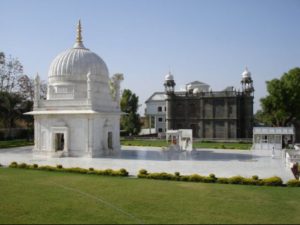
At a distance of 58 kilometres from Dungarpur, located on the banks of River Mahi, is a hamlet called Galiakot. The place is known for Syed Fakhruddin’s shrine. He was a renowned saint who was buried in the hamlet after his death. The shrine is made from white marble and has his teachings engraved on it walls. The inner portion of the dome is decorated by beautiful foliage while teachings of the Quaran are engraved in golden letters on the tomb.
Nagfanji
Nagfanji is renowned for its Jain shrines and not only does it attract devotees from Dungarpur but also tourists who travel from far to see the temple. The temple houses statues of Devi Padmawati, NagfanjiParshwanatha and Dharnendra.The Nagfanji Shivalaya,which is located close to this temple, is also a tourist attraction.
Shrinathji Temple
MaharawalPunjraj built this temple in the year 1623. The idols of Shri Radhikaji and GoverdhanNathji are the main attractions. The complex also houses several shrines dedicated to Shri BankeBihariji and Shri Ramchandraji.
Surpur Temple
This ancient shrine is located on the banks of the Gangdi River about 3 kilometres from Dungarpur. The area around the temple also houses other attractions such as Bhulbhulaiya, Madhavrai Temple, Hathiyon Ki Agad and several inscriptions.
Beneshwar Temple
The Beneshwar temple, containing the most revered Shiva Linga of the region, is situated on a delta. formed at the confluence of Som and Mahi rivers. The Linga is believed to be Swayambhu or self created .It stands five feet high and is spilt broken at the top in five parts. Just near the Beneshwar temple is the Vishu temple constructed in 1793 A.D. by Jankunwari, daughter – in law of Mavji, a highly revered saint and believed to be an incarnation of Lord Vishnu. The temple is said to be constructed at the place where Mavji spent his time praying to God. Two disciples of Mavji called Aje and Vaje built the Laxmi Narayan temple. Though these are other Gods and Goddesses, People identify them as Mavji, his wife, his son, his daughter-in law and disciple Jiwandas. Besides these temple, there is also a temple of Lord Brahma.
Fairs & Festivals of Dungarpur
Beneshwar Fair
The biggest tribal fair held at Beneshwar which is at the confluence of Mahi, Som and Jakham rivers. A large number of tribals from Rajasthan, Guarat and Madhya Pradesh gather to immerse the mortal remains of the dead. This fair is held on Magh Purnima,in the month of February, which is considered a holy period in this region.

Geography of Dungarpur
A major part of the district is characterized by a rugged terrain. The North East- South trending Aravali hill ranges are prominent in the western part. The ground elevation of the area is about 320 mts. While the hills rise upto 552mts. above MSL. Som & Mahi the two major rivers of the District. The area is drained by a network of streams that discharge their water into the Mahi river.
Mineral Resources of Dungarpur:
Dunagarpur has a rich assemblage of minerals. The important one are Soapstone, Fluorrite, Green marble Base matail etc.
Dunagarpur has a rich assemblage of minerals. The important one are Soapstone, Fluorrite, Green marble Base matail etc.
Base Metals
Occurrences of copper are found near padar-ki-pal, Amjera, Dewal, Methali. Odenetc.
Flourite
The largest fluorite deposits in the state are located in mandoo ki-pal, areas in this district. Other important localities are kahila Remore, Mata Bhagat, Rahatwali Thurwali, Umeria, Singhwali and Nawagaon. Fluorite is used as flux in metallurgy of iron and aluminum. Acid grade fluorite is used manufacture of Hydro-Fluoric acid which is subsequently used in glass and chemical industries.
Soapstone:
The important localities are Dewal, Jakol, Thana, Rohanwara, Pipoloda. Sabli MUnger, Padar, Amjera, Parsola, Bharkubdi Sarkan, Surata-ki-pal etc. It is used in cosmetics, refractories, paper & paint, pesticide and insecticide industries.
Asbestos:
Crysotile variety of Asbestos is found sporadically near Dewal, Jadol, Gokulpura etc. Villages associated with ultra basic rocks. Tremilite varriety is also form fairly workable deposits.
Marble:
Serpentine rocks are being miend as green marble near Dewal, Surata, Dachki, Hirata, Simalwara, etc. Villages. The marble takes good polish and has good market.
Limestone:
Crystalline pink-grey-white limestone occurs in two belts in Dugarpur district near sabla, Mungar, Harwar etc. villages. Another limestone band occurs near Harwar, Nithuwa villages. It is off white to grey in colour. It is also being used as marble.
Building Stone
There are large Occurrences of slates and phyllites which are being mined at places for use as building stone. Phyllites are excavated near Rampura, Denandi, Baramagra etc.
Population of Dungarpur
According to the 2011 census, Dungarpur district had a population of 13,88,906. The district had a population density of 368 inhabitants per square kilometer. Its population growth rate over the decade 2001-2011 was 25.39%. Dungarpur had a sex ratio of 990 females for every 1000 males and a literacy rate of 60.78%.
