
Location, Area & Administration of Jalore:
Jalore district situated in the south western part of Rajasthan, formed out of the erstwhile Jodhpur state after independence. This district is situated between 24.48″ 5′ to 25.48″ 37′ North Latitude and 71.7′ to 75.5″ 53′ East Longitude. The North Western border of Jalore is shared with Barmer, North Eastern boundary is shared with Pali, towards South East lies Sirohi and in south state of Gujarat is in contact.
The total area of the district is 10,640 Sq. KMs, which is 3.11% of the State. The district is divided into 7 tehsils of Jalore, Ahore, Bhinmal, Raniwara, Sanchore, Sayla, Bagoda, Bhadrajun, Chitalwana.

History of Jalore:
According to mythology, Jalore was called as ‘Drumkulya’ , which stood for the northern part of southern Ocean. Jalore’s old name was Jabalipur named after a saint- Mahirishi Jabali. By the passage of time the name of mountain Kanchangiri & Swarngiri were also frequently used as names of Jalore.
Prathihar king VatsaRaja was the ruler of Jalore during 8th century.
Towards the end of 12th Century, Parmars ruled here. Historians believe that the Jalore fort was built by Parmar rulers. It is known from a stone inscription of 1238 A.D. of fort that Parmar King Biral’s-queen Maludevi powered Gold win on Sindhu King.
Nadol king, Arhan’s, youngest son Kirtipala started Chouhan tradition in Jalore. The Chauhan lineage of Jalore is as under:
- Kirtipala (c. 1160-1182 CE)
- Samara-simha (c. 1182-1204 CE)
- Udaya-simha (c. 1204-1257 CE)
- Chachiga-deva (c. 1257-1282 CE)
- Samanta-simha (c. 1282-1305 CE)
- Kanhada-deva (c. 1292-1311 CE)
- Wrote Kanha-Prabhandha: Epic elaborating war between Kanha Dev & Alaudin Khilji.
Subsequent Rulers:
- Rathore king Rao Maldev ruled the fort of Jalore in 15th Century.
- During Akbar’s rule, Abdul Rahim Khan Khana took it infinitely from Gazni Khan.King.
- Jehangir built the walls of the fort.
- After the death of Aurangzeb it permanently became a part of Jodhpur.
Historical Places of Jalore:
Jalore Fort:
Jalore Fort is one of the nine castles of the Maru’, under the Paramaras in the 10th century. It has been known through history as the Sonagir or the ‘golden mount’. The precise year of its construction is not known however it is believed to be built between the 8th and 10th centuries. Jalore fort is located atop a steep and perpendicular hill 336m high, fortified with a wall and bastions with cannon mounted upon them. The fort has four gigantic gates and is approachable only from one side, after a two-mile long serpentine ascent.
Topekhana:
Topekhana or “the cannon foundry” was built by “Ujjain King” Vkramditya as a “sansrut Pathshala” for education for his public. Later, Muslin Emperor Ala ud din Khilji converted it into a Muslim monument. The structure is imposing, with a spacious forecourt and an intricate facade. The colonnade and the ceiling have been tastefully carved.
Sundha Mata: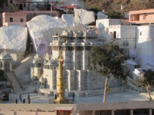
Sundha Mata temple is about 900 years old temple of Mother goddess situated on a hilltop called ‘Sundha’. At 1220 m height in the Aravalli ranges there on Sundha mountain is temple of goddesses Chamunda Devi, a very sacred place for devotees.
Dances of Jalore:
Dandiya Dance:
This dance start after holi and continues for many days. In the middle of stage the shehnai players, Nagada beaters and singers sit and male Singer sings ‘Folk Lori’ in lengthy song. Dances beating their sticks together dances parallel with this dance various Dhamal & dance oriented holi songs are sung.
Jalore Dhol Dance:
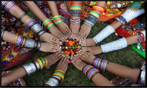 This dance is performed on the occasion of marriage by mali, Dholi, Sargaras and people of Bhil Communities. It is predominantly a male dance and at start leaders beat drum in ‘Thakna Shaili’. As soon as thakna ends some dancers puts swords in mouth, some with lathis and others taking handkerchief in hands rest only manage body thus the dance starts. Sargaras & Dholis are professional folk singer & drum beaters who are very proficient in the art.
Gair Dance:
 This also also involves male, who take long sticks and dances around. Dancers are called ‘Gairiya’. This dance start next day from holi and lasts fifteen days. Drums, Baakiya and Plate(Thaali) are used for playing music. Folk songs influenced by. “Shringar Ras” & “Bhakti Ras” are also used in this dance. Dancers wear white clothes from shoulder to waist, leather belt is tied, there is also a place for keeping sword in it, frills are tied on the turban.
Crafts of Jalore:
- Handloom work is done at Leta, Jelatara, Degaon, Pur, Vodha, Vasandevda, Lalpura, Bhatip, Khara, Gundau.
- Bhinmal is famous for its Leather traditional footwear (Juti)
Geography of Jalore:
Physiographically, the district is oblong in shape, extending up to Rann of Kutch (Gujarat). The region is generally plain but for some scattered thickly wooded hills in the north and some hillocks in the centre. The eastern portion of the district is rocky while the western tract is a roughly plain dotted with Sand dunes & sand ridges.
In respect of its geological formation, most part of district is formed of fourth century modern century deposits. These deposits can be seen in Grid pattern formed by sand (Balu), new alluvial and old alluvial Soils. In Bhinmal Teshil’s South Eastern part of Jaswantpur, highest mountains of the district are situated. the highest peak is Sundha (991 meters, 3252 feet).
Luni is the main river in the district with its tributaries Jawai, Sukdi, Khari, Bandi and Sagi. All the rivers are seasonal.
Natural Places of Jalore:
Sundha Mata Wildlife Sanctuary: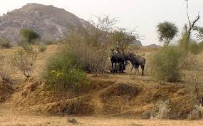
Sundha Mata wildlife sanctuary has an area of 107 square kilometers and is located in jawai forest area. The Sanctuary has Sloth Bear, Nilgai, jungle cat, Desert fox, striped hyena, hanuman langoor, Vulture, owl, Indian porcupine, rock &jungle Bush Quail & Spotted dove and 120 species of birds.
Natural Resources/Minerals of Jalore:
The following are the rocks and mineral resources of Jalore district:
Fluorspar
- Fluorspar is an important industrial mineral and is the only major source of fluorine.
- It is chiefly used in the manufacture of hydrofluoric acid, as a flux in steel making, as an opacifier and flux in the ceramic industry.
- Fairly large deposits of fluorspar have been discovered near village Karada of Tehsil Bhinmal.
- The main activities of mining are located at Krisna hill, Rekha hill & Santoshi hills.
Granite
- The granite rocks belong to the Malani System of rocks.
- The Siwana and Jalor granites provides rocks of high fassinating colours ranging from flesh to pink and light colors .
- The main activities of mining are located at Khambi, Kavala, Tayab, Bala, Raniwara Khurd etc.
Clay
- Clay occurrence has bee reported near village Bhadrajun and Pal.
Saltpetre
- Village Kanwla in Tehsil Ahor has deposits of saltpetre.
- Saltpetre which is used for local pottery and fire works and ammunitions industry.
Gypsum
- Gypsum deposits are located near Ramsin, chawarda in Ahor Tehsil and at number of places in Sanchore Tehsil.
- Other small deposits are located near Vediya, Chittarwana, Sewada, Hemagura and Haryali area.
Other Minerals:
- Besides above, building stones and masonary stones, Bajri etc. have been produced in the district for local use since long back.
- Dolomitic marble is known to occur near village Rupi, 9.5 Kms. south west of Bhinmal.
- Minor occurrences of graphite and feldspar has also been found in the east of Bhinmal town.
Population:
- According to the 2011 census Jalore district had a population of 18,30,151.
- Its population growth rate over the decade 2001-2011 was 26.31%.
- The district has a population density of 172 inhabitants per square kilometer.
- Jalor has a sex ratio of 951 females for every 1000 males and a literacy rate of 55.58%.