
In Indian Geography, the soils of India, such as alluvial, black, red, laterite, and desert soils, are vital for its agricultural and ecological diversity, shaped by varied climate, topography, and geology. These soils, from the fertile alluvial plains of the Ganges to the arid desert soils of Rajasthan, underpin India’s agricultural economy and biodiversity.
General Introduction
- Soil is that layer of land which is formed by the disintegration of rocks and decay of fossils. It has the capacity to grow trees and plants. Its formation and quality depend on rocks, climate and vegetation.
- The main factors affecting soil formation are relief, parent material, climate, vegetation, location and time. Apart from this, human activities affect soil formation to a considerable extent. Different types of soil develop in different geographical environments .
The following layers are found in the vertical profile of the soil .
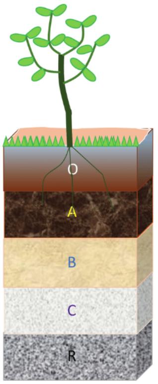
- Level O – Uppermost ground level with abundance of humus, organic material.
- Layer A – composed of fine matter. Usually black in colour and rich in organic matter. Supports plant life. Also called the eluvial or leaching zone.
- Layer – B – is called the zone of isopode or accumulation.
- Layer – C – is made up of weathered rock material.
- At the bottom lie the parent rocks, which remain unaffected by the process of soil formation
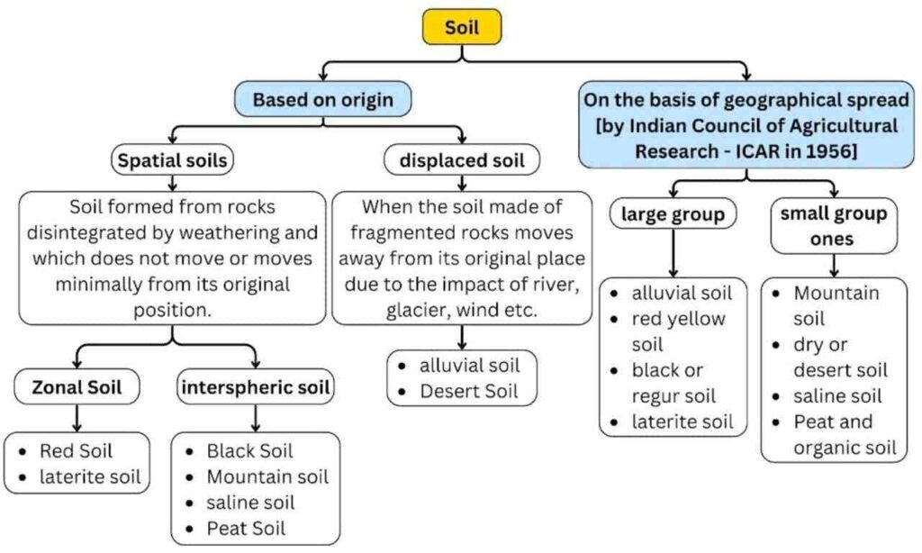
Soil Classification
The work done by the Indian Council of Agricultural Research (ICAR) in 1956 is the most important. ICAR has divided the soil into eight classes keeping in mind the colour and resource importance of structural soil and mineral soil –
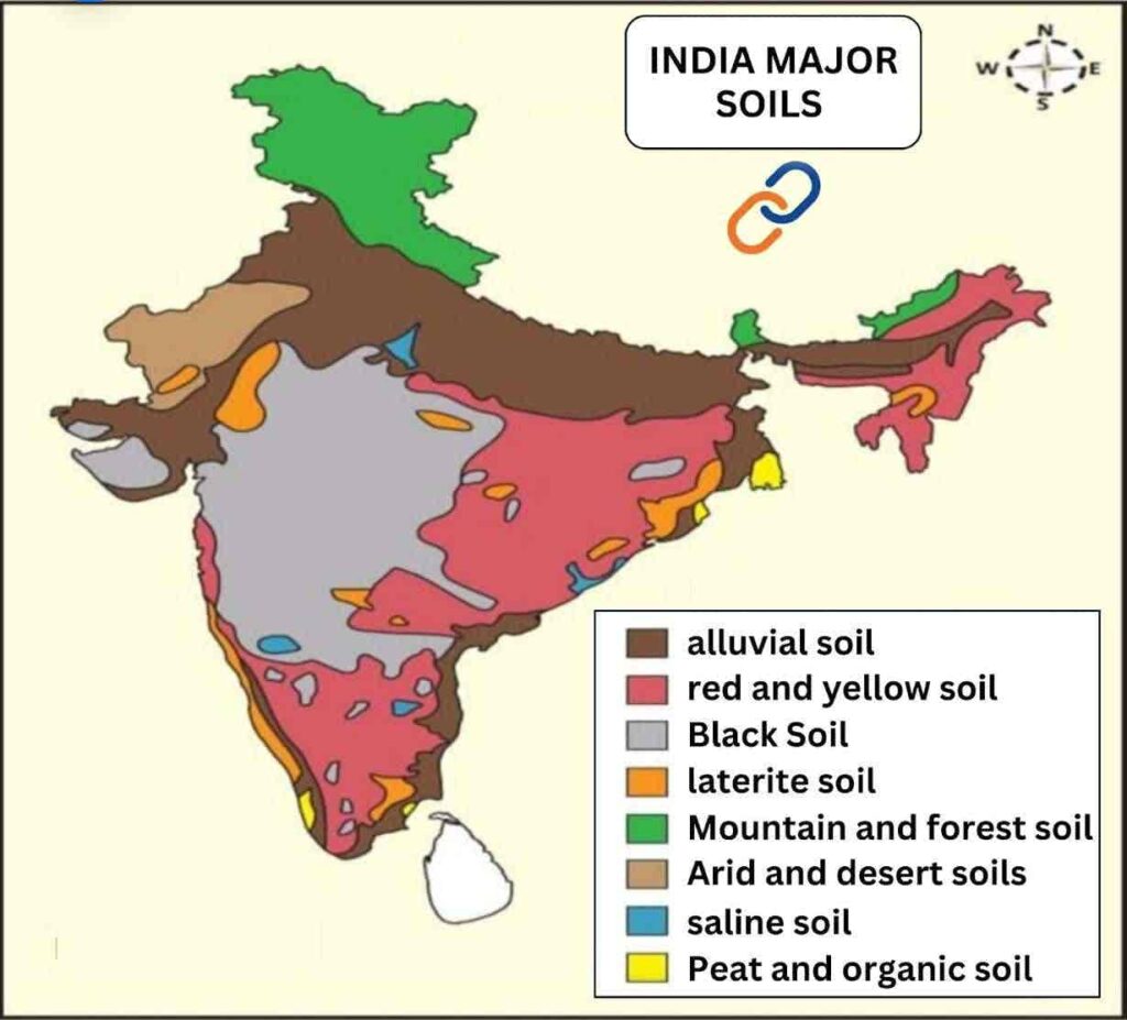
Alluvial soil
- Alluvial soil is basically formed from the deposits of sediments brought by rivers originating from the Himalayas or from the silt left behind by the sea after its retreat. It is also called ‘alluvial soil’ or ‘alkaline soil’.
- It is a depositional and Azonal soil. Its profiles are immature in undulating areas whereas they are fully developed and mature in plain areas.
- Generally, soil profile is not found in this soil.
- Area – Alluvial soil is found on most of the land area in India [43% of the total area of the gross reported soils of the country]. Alluvial soil is most developed in the northern plains of India. Apart from this, this soil is also found in the river basins and deltaic regions of coastal plains and peninsular India.
- Characteristics
- Due to the presence of various types of rock minerals, this soil is very fertile, so various crops are cultivated in it.
- There is a lack of nitrogen, phosphorus and vegetation (humus) content but potash and lime are found in adequate quantity.
- The colour is light grey to ash grey which depends on the depth of deposition, formation and time period taken in formation. The formation is found to be of sandy loam to clayey soil (clay loam) nature.
- Sandy loam soil has the lowest water holding capacity because it contains a large amount of crystals whereas clay alluvial soil has the high water holding capacity.
- Mainly wheat, sugarcane, barley, pulses, oilseeds and jute crops are grown in this soil.
- Based on the geographical conditions, alluvial soil/alluvial soil is divided into three parts:
|
ancient alluvial soil |
|
|
new alluvial soil |
|
|
latest alluvial soil |
|
|
Red-yellow soil
- It is the second major soil of India(area-18%), which has developed in those areas of low rainfall, where crystalline igneous rocks (granite and gneiss) are found.
- Expansion – Eastern parts of Madhya Pradesh, southern parts of the middle Ganga plain, some districts of West Bengal on the Chota Nagpur plateau, some parts of Odisha and Chhattisgarh, Garo-Khasi-Jaintia hills of Meghalaya, Nagaland, eastern areas of Aravalli mountain of Rajasthan and some parts of south-eastern Maharashtra, Karnataka and Tamil Nadu, Andhra Pradesh.
- Due to the development of this soil in most of the areas of the peninsular plateau, it is also called ‘zonal soil’.
- Features
- Predominance of iron, aluminium and lime but lack of humus, phosphorus, potash and nitrogen. It is acidic in nature.
- Its colour is red due to the presence of iron oxide but in hydrated form it appears yellow.
- Red and yellow soils with fine particles are generally fertile, while soils with coarse particles are infertile.
- Its layer is thin. Its depth is more only in river valleys. This soil requires frequent irrigation.
- Severe erosion is a major problem of this soil.
- Red soil is useful for the cultivation of millets, groundnuts and potatoes on higher lands, while rice, ragi, tobacco and vegetables etc. are cultivated in the lower lands. Rubber and coffee plantations are being developed in this soil in Tamil Nadu and Karnataka.
Black or regur soil
- The third major soil of India, which is known as Regur, Black Cotton Soil and Tropical Chernozem internationally. In Uttar Pradesh, it is called Karel.
- The soil is formed by the disintegration of lava material [basalt rock] emitted from fissure eruption.
- Area – The area is 15% of the total soils. Maximum development – in the north western region of Deccan Trap of Maharashtra, besides this Malwa Plateau of Madhya Pradesh, Kathiawar Peninsula of Gujarat, Telangana Plateau, Bangalore-Mysore Plateau of Karnataka, Coimbatore-Maturai Plateau of Tamil Nadu, South-Eastern Rajasthan and Rajmahal Hills.
- Properties
- Soil is black in colour – due to the presence of titaniferous magnetite salts.
- Black soil is clayey, deep and impermeable, it becomes sticky when wet and forms large cracks when dry, which makes it look as if it has been ploughed automatically [self-ploughed soil].
- Due to fine particles, the water retention capacity of the soil is highest , hence the need for irrigation is less. Hence, this soil is suitable for dry agriculture.
- The soil has excess iron ,aluminium, potash and lime while it lacks nitrogen, phosphorus and humus.
- The soil is known as black cotton soil because it is more useful for cotton crops.
- Apart from cotton, sugarcane, groundnut, tobacco, fruits etc. are also grown in this soil.
Laterite Soil
- Laterite is derived from the Latin word ‘Later’ which literally means ‘brick’.
- This soil develops in those areas where there is high temperature and heavy rainfall [more than 200 cm]. Due to high rainfall, lime and silica are leached with water in lower layers of the soil and iron oxide and aluminium compounds remain in the soil.
- Area – 4% of all soils of India. The soil has developed mainly in the high areas of the peninsular plateau. Generally, the Eastern Ghats – Western Ghats, plateau areas of Karnataka, Kerala, Maharashtra and Odisha, Rajmahal Hills and hilly areas of Assam and the plateau of Meghalaya.
- Features
- Bacteria which thrive in high temperatures rapidly deplete the humus content, leaving it deficient in organic matter, nitrogen, phosphorus and calcium and rich in iron oxide and potash.
- Large quantities of manure and fertilizers have to be added to these soils to make them fertile for crops.
- Mainly tea, coffee, rubber, cinchona, cashew, coarse grains and spices are cultivated in this soil but it is classified as less fertile soil from the agricultural point of view.
- Laterite soil is used to make bricks for building houses.
Mountain and forest soil
- In mountainous regions, the climatic conditions change with altitude due to which different types of soil are found here.
- Area – About 5.5%/ 8% of all soils. Mainly Found in Himalayan mountainous region, hilly areas of north-eastern India, Western and Eastern Ghats and hilly areas of peninsular India.
- Features
- The structure and composition of the soil also changes according to the changes in the mountain environment. In the valleys it is usually loamy and on the upper slopes it is coarse grained in nature; the lower valleys are more fertile than the upper slopes.
- Mountain soil usually develops on the slopes of mountains and due to being affected by the problem of soil erosion, it is found in the form of thin layers. This soil has less depth and is porous.
- There is abundance of organic matter in the soil. These organic matter are mostly undecomposed, as a result humic acid is formed and the soil becomes acidic.
- This soil lacks potash, phosphorus and lime. The fertility of this soil is low.
- Being developed on hill slopes, this soil is very useful for plantation agriculture, such as tea, coffee, spices and fruit cultivation. Pastures are found in areas with less fertile soil.
- Jhum agriculture is done by the tribes in this soil.
Dry and desert soils:
- Dry soil has developed in dry climatic regions with high temperature. In these regions, due to negligible rainfall and excessive evaporation, there is less moisture in the soil and lack of organic elements, due to which there is lack of humus. Hence, it is classified as infertile soil from the agricultural point of view.
- Area – spread over about 1.42 lakh sq. km. (4.32%) to the west of Aravalli in Rajasthan, North Gujarat, South-Western Punjab, and South-Western Haryana. In recent years the desert has spread towards the east and some areas of South-Western Uttar Pradesh have also been affected by it.
- Features
- Desert soils range from sandy to gravelly. Calcium, iron and phosphorus are also found in sufficient quantities in it but there is a lack of nitrogen and humus, due to which it is sandy from the point of view of structure and alkaline/saline soil from the point of view of nature, which is infertile for crops.
- The amount of soluble salts is high while the moisture content is low and the capacity to retain moisture is also low.
- Where there is less rainfall, sand dunes keep forming.
- This soil is less fertile but its fertility increases in irrigated areas, because due to no leaching, the nutrients are present in the upper layer of the soil. In areas where irrigation facilities are available, sugarcane, cotton, jowar-bajra and vegetables etc. are grown.
- Generally, crops requiring less water are grown, such as jowar, bajra, ragi, oilseeds etc.
Saline soils
- Saline soil develops in dry and semi-arid climate and in waterlogged and anhydrous areas. Such soils are also called barren soils.
- Area – Mostly spread in Western Gujarat, Western Rajasthan, Southern Punjab, Southern Haryana, Kerala coast, left bank of Ganga, eastern coast deltas and Sundarbans of West Bengal.
- Features
- These soils can range from sandy to loamy in structure. Since they contain an abundance of salts, they contain an excess of sodium, potassium and magnesium and a deficiency of nitrogen and lime.
- They are infertile and no vegetation grows in them.
- In dry climate areas, excessive irrigation due to intensive agriculture promotes capillary action, in which sodium, potassium and calcium salts and alkalis accumulate on the upper layer of the soil. As a result, the soil turns into saline soil.
- In the areas of Punjab and Haryana, due to excessive irrigation, the spread of saline soil is increasing. Due to which the fertile alluvial soil is getting converted into infertile soil. Here this type of soil is called Reh, Usar and Kallar.
- Salt particles come to the Rann of Kutch with the south-west monsoon, which get deposited on the upper surface in the form of a hill. The development of saline soils is promoted by the filling of sea water in the delta region.
- Saline soils can be made cultivable by using gypsum and pyrite.
- Saline resistant crops and fruit trees like Berseem, paddy, sugarcane, guava, amla, phalsa and jamun are planted in the soil.
Peat and organic soil
- Soil is formed due to waterlogging in the deltaic areas formed by rivers.
- Area – Mostly in parts of Kottayam and Alappuzha districts of Kerala, coastal areas of Odisha and Tamil Nadu, Sundarbans of West Bengal, northern parts of Bihar, southern parts of Uttaranchal, Almora in Uttar Pradesh.
- Features
- These soils are found in areas with heavy rainfall and high humidity where vegetation growth is good.
- Since physical and chemical changes are negligible in this soil, the amount of undecomposed organic matter is high, due to which the acidity of the soil also becomes relatively high. But there is a lack of potash and phosphate in it.
- The amount of organic matter in these soils is 40 to 50 percent.
- These soils are generally dark and black in color.
- In India, ‘mangrove vegetation’ has developed more in the areas with peat soil.
- This is a suitable soil for crops with light fertility.
ICAR has classified the soils of India in the following order as per “USDA Soil Taxonomy”
|
S No |
% |
Description |
|
Inceptisols |
39.94 |
Poorly developed soil found in alluvial plains and mountainous and valley regions.Soil profile not fully formed.High water holding capacity and fertile. |
|
Antisols |
28.08 |
Immature soil [Formed by deposition by winds or physical factors]No profile formation in the soil.Found in desert areas. |
|
Alfisols |
13.55 |
Partially leached soil.Abundance of aluminium, iron, calcium, magnesium, potash.Red coloured fertile soil found in humid and sub-humid regions. |
|
Vertisols |
8.52 |
Black soil of clayey nature. High water holding capacity.Self-ploughing soil. |
|
Aridisols |
4.28 |
Arid and semi-arid areas.Excess of lime and phosphorus and deficiency of nitrogen, potash and humus.Low water holding capacity. |
|
Ultisols |
2.51 |
Tropical regions.Leached soil due to excessive rainfall.Abundance of iron and aluminium oxides. |
|
Mollisols |
0.40 |
In the temperate zone.Soil with abundant humus and dark colour.Chernozem is another name for this type of soil. |
|
other |
2.92 |
Characteristics of Indian soils
- Most of the soils are ancient and mature, with the soils of the peninsular plateau being older than those of the northern plains.
- They are deficient in nitrogen, mineral salts, humus and other organic elements.
- The soil layer is deep in the plains and valleys while it is thin in the hilly and plateau regions.
- Alluvial and black soils are fertile, while laterite, desert and alkaline soils are less fertile and unsuitable for agriculture.
- Most of the soils have lost their fertility due to long-term cultivation.
Soil related problems
- Soil erosion (Himalayan region, Chambal ravines etc.), loss of fertility (red, laterite and other soils), desertification (around Thar Desert, rain-shadow areas like Karnataka, parts of Telangana), water-logging (Punjab-Haryana plains), salinity and alkalinity (highly irrigated areas like Punjab, Haryana, Karnataka), barren lands, over-exploitation of soils due to population growth and improvement in living standards and encroachment of agricultural land due to urbanisation and transport development.
Salinity and alkalinity
- Salinity and alkalinity are chemical properties of soil, which are especially found in irrigated agricultural areas.
- This is due to the rate of evaporation being higher than the rate of rainfall, drought, excessive irrigation, increased toxicity, and high groundwater level.
- Under these conditions, salts of sodium, calcium and magnesium get deposited on the surface and make the soil barren, making it unsuitable for agriculture.
- Area
- About 80 lakh hectares of land and 2.4% of the agricultural area in India is affected by this problem.
- 3.6 million hectares of land is affected by salinity and alkalinity under desertification and land degradation.
- Major areas: Canal irrigated areas of Punjab, Haryana, Uttar Pradesh; arid parts of Rajasthan; semi-arid areas of Maharashtra, Gujarat, Madhya Pradesh, Andhra Pradesh and Karnataka; and eastern and western coastal areas.
- A large formation of salt flats badly damaged by calcium chloride exists in Kutch region.
Waterlogging
- When the water level of the area rises to such an extent that the soil pores of the crop roots become saturated, as a result, the normal cycle of air in the soil is disrupted and the amount of oxygen in it starts decreasing and the amount of carbon dioxide starts increasing.
- Main reasons of water logging-
- Leakage of water from canals
- Improper management of farm water
- Lack of drainage
- Excessive and intensive irrigation.
- Excessive rainfall, it seeps into the soil and thus increases the level of water absorbed by the soil.
- Changes in the marine delta cycle
- Sea waves inundating the coastal area
- Area – 807000 in India. Land degraded due to water logging. Some parts of Indira Gandhi Canal, a large part of agricultural land in the states of Punjab, Haryana and Uttar Pradesh.
- Effects of waterlogging
- Lack of aeration in the soil.
- The pH of the soil decreases.
- Decrease in soil nutrients.
- Increase in salinity.
- It also has an adverse effect on human health.
- Farming problems
- Low soil temperature
- Prevention of waterlogging
- Construction of artificial open and underground drainage grids.
- More intelligent use of water, by reducing the intensity of irrigation.
- No use of saline water for irrigation.
- Promotion of rain water harvesting.
- Adoption of mulching process to minimise moisture loss and ultimately reduce the intensity of irrigation.
|
Degradation
|
Soil erosion
- The erosion or wearing away of the top layer of soil by flowing water or wind is called soil erosion. When this rate exceeds the rate of soil formation, a serious problem of soil degradation arises.
- 30% of India’s land area is experiencing “minor” soil erosion, and 3% is experiencing “catastrophic” topsoil loss.
- The Brahmaputra Valley in Assam is considered the largest center of soil erosion in the country.
Factors Contributing to Soil Erosion:
A. Natural causes:
- Wind erosion – Strong winds can pick up and carry away loose soil particles, especially in arid areas where vegetation is sparse. Rajasthan, Haryana, Punjab, western Madhya Pradesh and Gujarat are the major affected areas.
- Water erosion – Strong currents and heavy rainfall carry away soil from sloping lands, especially in areas devoid of vegetation.
- Glaciers and ice – Glaciers erode rocks and soil and deposit them as moraine in the lower valleys.
B. Human-induced factors:
- Deforestation – Indiscriminate exploitation and cutting of forests increases the intensity of erosion.
- Poor agricultural practices – Shifting agriculture
- Overgrazing
- Construction activities
Region – Western and Eastern Ghats, Chota Nagpur Plateau, North-eastern region, Shivalik range of Himalayas, dry and semi-arid areas of Rajasthan, Gujarat, Madhya Pradesh, Haryana and Punjab
Stages/Types of Soil Erosion
- Splash Erosion –It is the initial stage of soil erosion in which the soil particles are disintegrated due to the impact of raindrops on dry soil, thereby disintegrating the upper layer of the soil.
- Sheet Erosion – Due to the continuous impact of the drops, the soil starts eroding in the form of thin layers. It happens after heavy rainfall on plain lands. This process is more harmful as the fine and highly fertile layer of the soil gets eroded.
- Rill Erosion – Fast flowing water creates small and shallow gullies on the land. This usually happens in agricultural land and overgrazed areas.
- Gully Erosion – When the channels of rill erosion become large and wide, they break up agricultural lands into small pieces, making them unsuitable for agriculture. This is called ‘aberrant land’, example – the rugged region of Chambal.
- Stream Channel Erosion – When water starts flowing as a thick stream and erodes the channel until it attains a steady slope.
Solution
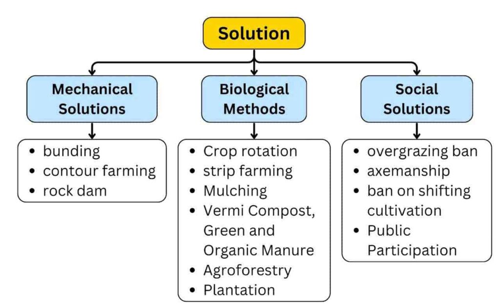
Note- To control soil erosion and its ill-effects in the country, the Central Soil Conservation Board was formed in 1953.
Land degradation and desertification in India
- 97.85 million hectares of India’s area (29.77% of total geographical area of the country) faced land degradation during 2018-19.
- During the time period 2011-13 and 2003-05, 96.40 million hectares (29.32%) and 94.53 million hectares (28.76%) of land was degraded respectively.
- Total increase in land degraded area between 2011-13 to 2018-19 – 1.45 million hectares (0.44% of total geographical area).
- Cause of land degradation/desertification in India –
- Water erosion [11.01%]
- Vegetation loss [9.15%]
- Wind erosion [5.46%]
- Land degradation in dry regions (arid, semi-arid and dry-sub-humid) is called desertification.
- A total of 83.69 million hectares of area was affected by desertification in 2018-19.
- Increase in desertified area between 2011-13 and 2018-19 – 1.05 million hectares.
- Wind erosion is the main cause of desertification in dry areas.
- Water erosion and vegetation loss are the main causes in semi-arid and dry-sub-humid areas.
- About 23.79% of the area affected by desertification/land degradation in relation to the total geographical area of the country was from Rajasthan, Maharashtra, Gujarat, Karnataka, Ladakh, Jharkhand, Odisha, Madhya Pradesh and Telangana.
- In terms of their total geographical area (TGA), Jharkhand, Rajasthan, Delhi, Gujarat and Goa have more than 50% of their area facing desertification/land degradation.
Soil Health Card
- Launched by – PM Modi on 19th February 2015 from Suratgarh, Sri Ganganagar, Rajasthan.
- This card indicates the nutrient status of the soil of a particular field and also recommends appropriate quantity of nutrients required to improve its fertility.
- SHC is a report which contains the status of soil with respect to 12 parameters, namely
- N, P, K (macronutrients);
- S (secondary-nutrients);
- Zn, Fe, Cu, Mn, Bo (micro-nutrients); and
- pH, EC, OC (physical parameters).
- Every farm will get a soil card once every 3 years.
